Organ Mountains
Organ Mountains create a small range that rise to the east of the city of Las Cruces in southern New Mexico. The range runs north-south and is less than 15 miles long. When viewed from Las Cruces, the peaks of Organ Mountains appear as needles similar to the pipes of a giant organ rising 4 to 5000 feet above the desert floor.
![Organ Needles]() Organ Mountains
Organ MountainsOrgan Peak
At 8872 ft, Organ Peak is the third highest peak in the range (after Organ Needle 9012 ft and Little Squaretop 8919 ft) but is the highest summit that can be reached without technical difficulties.
![]()
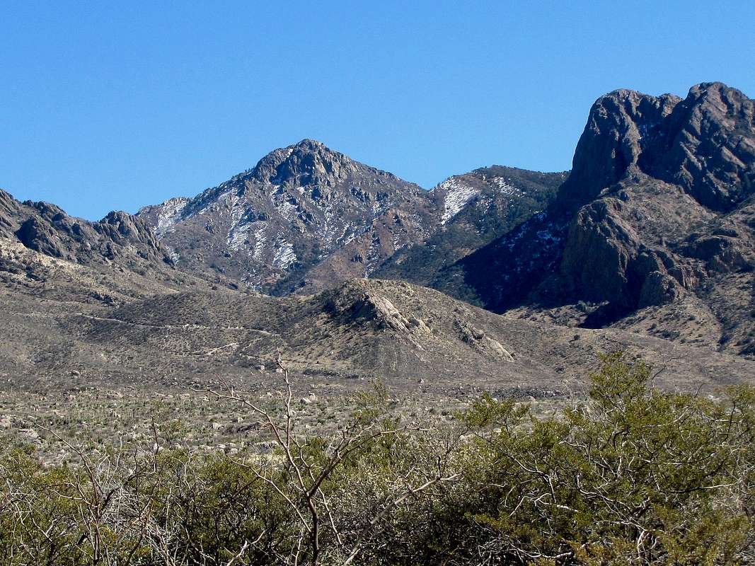
West face of Organ Peak from Baylor Canyon Road
![]()
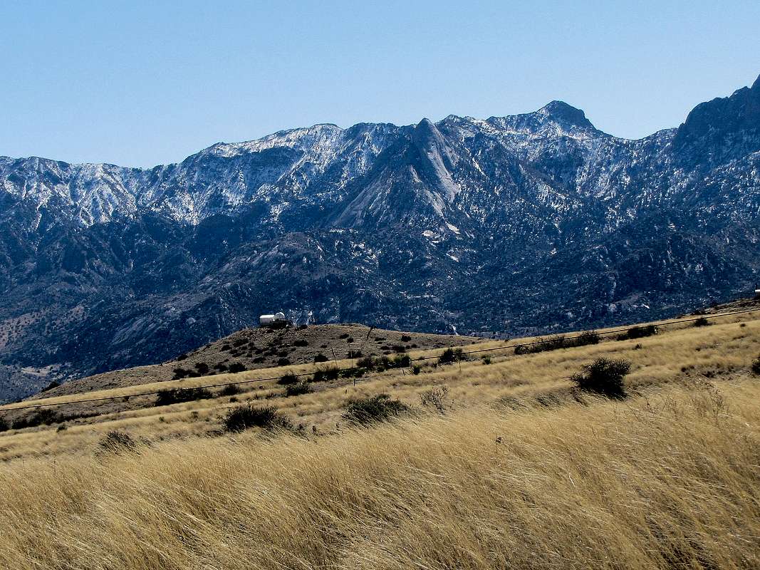
North face of Organ Peak from the junction of Route 70 and Aguirre Springs Road
Why I stopped 500 ft. below the summit
The gate that would not open until 8:00 a.m.
The Dripping Springs/Fillmore Canyon Trailhead where the hike starts has a gate that does not open until 8:00 a.m. For a peak that has 3500 ft of vertical and 10 miles of roundtrip, 8:00 a.m. may be too late of a start (sunrise was 6:50 a.m. on the day that I did the hike). I thought of parking behind the gate and starting my hike from there, but that would have added roundtrip 3 miles of hiking and several hundred feet of vertical not saving me much time.
Losing the path.
No official trail goes to the summit of Organ Peak. An unsigned beaten path branches off of the Fillmore Canyon Trail going to Organ Peak. I had looked at satellite photos looking for traces of the path and had erroneously come to believe that the path went on the north side of Fillmore Canyon. This mistake cost me an hour.
Deep soft snow.
Above 7500 ft, the path was covered with soft snow that I sometimes sank in knee deep.
Due to these delays, by 12:30 p.m. I had only reached an elevation of 8370 ft. The summit appeared close but there seemed to be much bushwhacking ahead. I wanted to make it back to trailhead before sunset so I turned around.
Hike statistics
Trailhead Elevation: 5390 ft
Maximum Elevation Reached: 8370 ft
Roundtrip Hiking Distance: 9.75 miles
Distances from Fillmore Canyon Trailhead:
Junction with trail from Dripping Springs Trailhead: 0.8 miles
The Narrows: 3.05 miles
Where you leave canyon to hike ridgetop: 3.85 miles
Trip report
Saturday February 13, 2016
As it began to light up, I started seeing the Organ Mountains from the big windows of our vacation rental house near the mountains. I knew the darn gate at the trailhead would not open until 8 a.m. but I just could not stay in bed any more. Got up by 6:40 a.m. The mountains were now well visible from our backyard. It was very frustrating to have to sit and wait.
![Organ Needle and Organ Peak]() Organ Peak from the backyard
Organ Peak from the backyard
Left the house at 7:30 and drove a few miles east on Dripping Springs Road to reach the closed gate. A number of other vehicles were already waiting there. Luckily, the ranger came at 7:45 and opened the gate. He said since it was Valentines Weekend, we did not need to pay the $ 5 entrance fee. I then drove a mile and a half further and parked at Fillmore Canyon Trailhead. It was 5390 ft there. Organ Peak was not visible but The Needles were in good view.
![Organ Needles]() Organ Needles
Organ Needles
In Las Cruces, it was supposed to be 44 degrees F going to a high of mid 70s F. I was in the shade. Started my hike at 8:00. A group of 3 hikers who seemed to be men in their 50s came to the parking area at the same time as me and started their hike ahead of me. I saw them for the next hour or so but then did not see a single person until later in the day when I was back at lower elevations. The trail went on a sloped desert plain to the east of a series of cliffs and began to go up slowly. After 0.80 miles, I reached the junction of a trail that came from Dripping Springs Visitor Center. Turned left, went through a hiker’s gate and continued on Fillmore Canyon Trail. I went past those 3 hikers.
I was on the impression that my path to Organ Peak went on the north side of Fillmore Canyon so I continued on the trail crossing the canyon, which at that point was just a small dry arroyo, to its north side. It was not until the end of the day when I was coming back that I realized that I should have left the trail just before the canyon and got on an unsigned beaten path that branched off of the trail staying on the south side of the canyon.
I then reached a fork in the trail. A sign in the right branch said “Trail” so I went right. A small canyon began to form and to my surprise, I began hearing running water. Where did that water come from and where did it go? I soon reached a waterfall. The water seemed to sink into the ground a short distance beyond the bottom of the falls.
![Waterfall]() Waterfall
Waterfall
Continuing up the canyon, I only saw a beaten path that went up a steep slope. This was obviously not the trail but I did not want to go back to the fork in the trail. Once I reached the top of the slope, the trail appeared. I saw those 3 hikers at a distance behind me on the trail. I was now below some of The Needles.
![Organ Needles]() The Needles
The Needles
At around 6100 ft of elevation, I came out of the shade into sunlight. Soon I began to feel very hot but fortunately as the day went on, I no longer felt hot. I stopped at a spot to put on sunscreen lotion. I was expecting to see the hikers behind me approaching but they did not. I could now see the plains to the west where the city of Las Cruces was some 2000 feet below.
![The plain below]() Looking back at the plain below
Looking back at the plain below
Continued up the trail on the slopes below the walls of The Needles.
![Organ Needles]() Walls
Walls
The trail then went down into the bottom of the canyon where Fillmore Spring was marked on the USGS Map. I did not see any water there. Having looked at satellite photos earlier, I was thinking that the trail would cross to the south side of the canyon at that spot. I had even written down the geographic coordinates of the supposed crossing. My GPS showed that I was very close to the spot. I kept looking on the south side of the canyon to find the trail but there was only an overgrowth of vegetation. In one place, I bushwhacked up the south slope but there was no trail there. This was disappointing. I came back to where the trail had dumped me into the canyon and went back on the trail to look for a path that I might have missed but there simply was no other way. Got back into the canyon and tried to hike upstream and downstream but the overgrown vegetation made the hike very slow and difficult. I was getting very frustrated. I did not want to give up and go back home so soon. I knew that the trail must have been somewhere up the south slope of the canyon so I bushwhacked up the slope and kept going. To my delight, the trail suddenly appeared. That wasted close to an hour. It was 9:50 and I was still only at around 6200 ft of elevation. My wanderings can be seen on the GPS track above.
Continuing up the trail/beaten path, it soon crossed to the north side of the canyon again. Organ Peak finally came to view but at that point I was not sure if it was Organ Peak.
![Organ Peak]() Organ Peak
Organ Peak
Looking back down the canyon, a long line of cliffs could be seen to the south. There was already some snow on the slopes in the shade of the cliffs.
Organ needle continued to loom above.
![Organ Needle]() Organ Needle
Organ Needle
I was now close to 7000 ft of elevation. Snow became more frequent. From there on, there was not a single human footprint over the snow. It had been 9 days ago that I had started look at the forecast for Las Cruces and in all that time the weather had been sunny. Therefore the snow was at least 9 days old and in all that time, not one person had come up there. Organ Peak was out of view again.
![Snow on the trail]() Snow
Snow
Snow hid the trail/beaten path. I knew that the canyon would soon turn left going into “The Narrows”. I went into the bottom of the canyon to make sure I would not miss the turn but the area was very overgrown. Bushwhacking slowed me down. The Narrows then came to view. It looked just like a picture I had seen on Summitpost.
![First view of The Narrows]() The Narrows
The Narrows
Went through the short section of narrows.
![The Narrows]() The Narrows The Narrows |
![The Narrows]() The Narrows The Narrows |
Beyond The Narrows, the trail was hard to find, either lost in the bush or under snow. The canyon made a few twists and turns.
![This is probably Organ Needle]() Organ Needle
Organ Needle
As expected, I reached the remains of a crashed airplane.
![Remains of crashed airplane]() Crashed airplane
Crashed airplane
On the USGS Map, I had seen that after The Narrows, four ridgelines came down into the canyon from Organ Peak. I knew that at the fourth ridgeline, I needed to leave the canyon and begin to hike up the ridgeline. Now that I was in the canyon, however, I could not count any ridgelines. I had nevertheless written down the GPS Coordinates of that spot by looking at satellite photos. Reading the source referenced at the bottom of this page, I had come to think that I would reach a 2-3 foot tall wall and that would be the place I needed to leave the canyon. After a while, I noted that bushwhacking had become particularly tough. My GPS showed that I had gone beyond the mentioned point so I back tracked to a place where a slab of rock covered the canyon. It was 7520 ft there and GPS coordinates were: 32 deg 20.369 min North, 106 deg 33.202 min West.
I left the canyon and went directly up a steep slope that was covered with bush and snow. No trail could be seen. I felt pain on my left lower leg close to my ankle. After removing the pants, socks and the liner, I felt a small cactus needle that I could barely see. How the heck did it go through the pants and the sock? I went to remove it but it broke. The remaining piece was so small that it could no longer be removed. It gave me pain for the next week. After a while I reached a place where the snow went away. A beaten path appeared. I was happy to see that. The summit of Organ Peak came to view too.
![Organ Peak]() Organ Peak Organ Peak |
![Point 7950 ft]() Point 7950 ft Point 7950 ft |
Continuing up the slope, deep soft snow appeared everywhere. There were no human foot prints and no sign of a trail. I was bushwhacking up the slope and at times sinking in the snow close to my knees. Much snow kept going into my boots. I had to often stop to remove the snow but my feet obviously got wet. I was on the north side of the crest of the ridgeline. Several times I tried to go the south side so that there would be no snow but the bushes were truly impenetrable.
![Soft deep snow]()
It was after 12 noon. I had told Mary I would be back by 3 p.m. and to start to worry if it became after 5 p.m. Now that I was out of the canyon, I was hoping that I would have telephone connection. The summit seemed close but with the bushwhacking, was probably still an hour or more away. I wanted to make sure I was back at the trailhead way before sunset at 5:50 p.m. The snow then went away but I could not see the trail anywhere. I was less than 100 vertical feet below the 8435 ft saddle at the base of the summit of Organ Peak but I gave up. At 12:35 p.m., I found a rock to sit on. Fortunately was able to call Mary. Had my lunch and enjoyed the views, especially of the spectacular Organ Needle on the other side.
![Organ Needle & Rabbit Ears]() Organ Needle Organ Needle |
![Baylor Peak & Rabbit Ears]() Baylor Peak Baylor Peak |
![Point 7950 ft]() Point 7950 ft Point 7950 ft |
![Organ Peak 8870 ft]() Organ Peak Summit Organ Peak Summit |
Left at 1:00 and began backtracking my foot prints and GPS track down the slope. I was now bummed that I did not make it to the top.
![Organ Needle]() Organ Needle
Organ Needle
Was in the canyon by 1:38, went through the narrows and was back on the trail/beaten path below the snow. Organ Peak appeared behind me again.
![Organ Peak]() Organ Peak
Organ Peak
Continuing down.
I then reached where in the morning I had bushwhacked up the canyon slope to reach the trail. I decided not to back track my morning route and to remain on the trail. I was sure that the trail would soon cross to the north side of the canyon but it remained on the south side. I could now see people hiking down the trail on the north side of the canyon where I had been in the morning. The band of cliffs close to the trailhead came to view far below.
![Cliffs above Fillmore Canyon Trailhead]() Cliffs near Fillmore Canyon Trailhead
Cliffs near Fillmore Canyon Trailhead
Continuing down.
The beaten path finally reached the Fillmore Canyon Trail close to the junction with Dripping Springs Trail. It was unsigned and inconspicuous compared to the well-established Fillmore Canyon trail. Now other hikers were appearing every now and then.
Reached Trailhead at 4:00 p.m.
![Fillmore Canyon Trailhead]() From Fillmore Canyon Trailhead
From Fillmore Canyon TrailheadExternal link
https://newmexicomeanders.wordpress.com/2013/05/14/2013-05-12-organ-peak/.


Comments
Post a Comment