Granite Peak via Froze-to-Death Route
Colorado: Training for Granite
My Granite trip actually started a few days earlier in Colorado, where my husband Michael and I did some hiking to acclimatize. We live at sea level (in fact, our home is 1/2 mile from the shore), so we definitely needed some practice at altitude before attempting anything serious. We decided to focus on south western Colorado as we hadn’t been there before. Our first hike was going to be Handies peak, an easy 14er, but it turned out our base of Durango, Colorado wasn’t exactly the best place to attempt Handies. The closest trailhead to Handies was on the other side of the mountains 4+ hours’ drive away: definitely too far for a day hike!
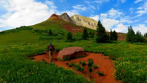
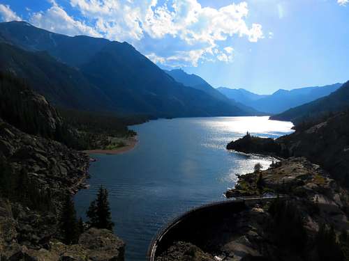
We found an alternate hike in Engineer Peak (12,900’), a beautiful mountain that sits on top of Coal Bank Pass, starting at 10,500’. Engineer had an easy approach on one of those nice, nearly-manicured western trails. The trail took us past fields of beautiful wildflowers and coniferous trees. Beautiful views opened up to the reddish colored mountains to the north of us. I was so happy we chose that route! We had intended to hike just a few miles in and turn around, but then the scramble up Engineer Peak looked kind of fun.. we would go up some distance and turn around. We came up to the chimney section at about 12,500’ for some great action shots before we decided to turn around. We really didn’t have the food or water required to continue to the summit. The descent down was very pleasant and easy. After coming back to our car, we decided to drive over to the lake at Molas Pass-it had started thunder storming, so we didn’t linger for too long. Later that afternoon, we decided to drive over to Mesa Verde National Park for some sightseeing. At 99 degrees and super-bright, it was in stark contrast to the conditions we experienced on Engineer Peak.
![Engineer Peak]() Engineer Peak
Engineer PeakFast forward two days later (it had rained in the intervening day), at 6am we were driving up the dirt road to Yankee Boy Basin, the main trailhead for Mt. Sneffels. I was initially attracted to that mountain by its fun name-actually named after the Snaeffelness Peninsula of Iceland; also affectionately known as the “Queen of the San Juans”. We parked at the 10,800’ parking lot since we had our little rental Corolla and started walking very slowly up the jeep road / trail. It was early in the morning and we saw one other person on the trail going up. The walk was easy up to the 12,500’ trailhead. The mountains that looked so tall when we started at the 10.8k trailhead all of a sudden looked smaller and more accessible by this point-in fact, we were above some of the mountains we saw at the trailhead!
![Sneffels - scree field]() Sneffels - scree field
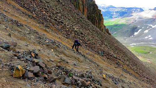
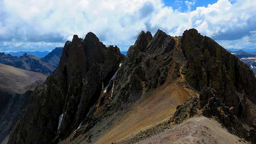
Sneffels - scree fieldAs we proceeded up the last 1.5 miles or so up to Sneffels, to our left lay Mt. Gilpin, a particularly majestic looking 13,600 footer, to our right was the vast scree field that would take us up to Sneffels. We walked carefully up the steep scree: it was very easy to dislodge fist-sized rocks and dust and even easier to take a tumble if you were not careful. Poles would have been helpful, but alas, I did not have any: I should remember to bring them on these hikes (I don’t use them on east coast hikes, as it’s more helpful to have free hands there). Once we got to the saddle, at 13,500’, a gorgeous view opened up all around us! In one direction was the previously lofty Mt Gilpin, surely a worthy hike in its own right; in another the pinnacles of the Sneffels massif (Gerry Roach calls them Kismet). From the saddle, it’s more of a scramble up the narrow couloir with the snowfield; then the chimney and finally a short scramble to the summit.
![Sneffels - Kismet]() Sneffels - Kismet
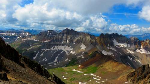
Sneffels - Kismet![Southern Colorado Mts]() Southern Colorado Mts
Southern Colorado MtsThe down climb to the base of the scree field was equally time consuming, but nevertheless, utterly breath-taking. In southwestern colorado, there are more shades of red and green in the mountains, indicative of their proximity to the state of reddish rock, Utah. Again, we took our time and a few tumbles, but thoroughly enjoyed the experience. At one point, along the jeep road/trail we saw a Toyota 4-Runner or something similar trying to go up the 4WD section and nearly tipping over: we told them we did not think their car would make it (they agreed and turned around). The drive down the rest dirt road was quick and enjoyable.
Montana Ho!
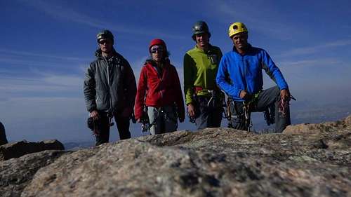
Two days later, I flew to Bozeman, Montana, where I would meet with my climbing team of 4 additional folks. I met my climbing team on Facebook initially: 4 Montana locals, with maybe 700 summits between them (mostly in Montana and neighboring states). Here I was meeting them in person: my first impression was that they were climbers, yep and really friendly. There was Cory, the experienced trip leader (who had climbed many hundred peaks and was working on his Montana 12ers list), Tyler, the quiet guy who had also climbed many hundred local peaks, Matt the truck driver/climber/Chris Sharma look-alike (who looked more like a climber than truck driver) and Izzy, Matt’s climbing partner. I felt out of my league, to be honest! Sure, I had hiked a great deal on the east coast & done 47 state high points, but who was I next to these super talented folks?
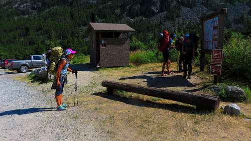
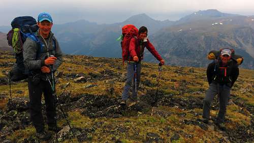
![Granite - start]() Granite - start
Granite - startWe drove to the trailhead at West Rosebud and started the trek. Our first top was Mystic Lake, where we would camp for the night. I was careful to go at a nice easy pace because I knew what was in store the following days! I had attempted Granite Peak 3 years prior with a guide service but was unsuccessful in the attempt-I had a monkey on my back! The camping spot was right next to gorgeous Mystic Lake and we were treated to a spectacular sunset. I managed to sleep well and woke up refreshed.
![Granite - Mystic Lake]() Granite - Mystic Lake
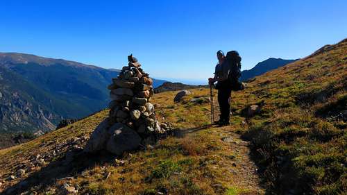
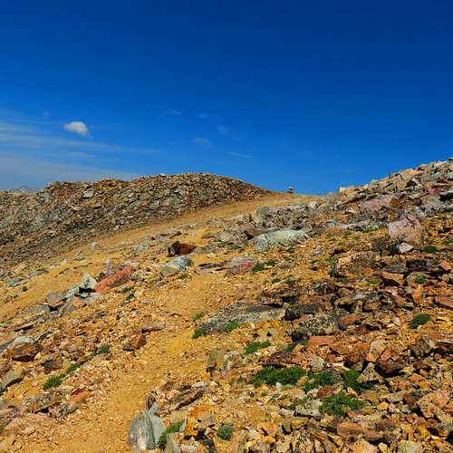
Granite - Mystic LakeThe next morning, after a little breakfast we started the climb up the many switchbacks up to Froze-to-Death Plateau. We gained elevation quickly and soon we were leaving treeline. Just before we exited treelike, Cory spotted a large black bear near the trail. We tried to be as loud and obnoxious as possible and the bear grew tired of us and mosied on. Tyler had a can of bear spray in his pack and led the rest of the hike up the switchbacks. We made good time up to the large cairn at the view point that signaled more or less the end of the trail portion of our day. At that point we were walking across a meadow littered with rocks.
![Granite - end of trail]() Granite - end of trail
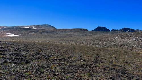
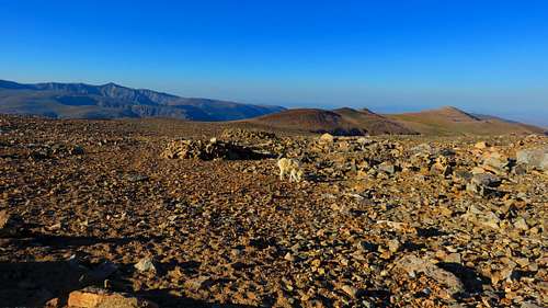
Granite - end of trailInitially the walk was quite easy and comfortable, but as we gradually gained elevation, there was less grass and more rocks. After a few miles it became a bit of a rock hopping fest: tough when carrying a fully loaded backpack. Needless to say I was getting quite tired: the load, the elevation and the rough terrain was wearing on me. I knew I’d be okay though when I saw Mt Tempest and Granite. the ending point of our hike for the day. Oh what a happy sight was Mt Tempest as we would camp there for the night. As soon as we plonked our packs down, a flock of mountain goats came for a visit: baby goats, yearlings, moms and dads all came by to say “hi”. They would be our constant companions for the next 3 days. Why would they be so interested in us? Was in the food? The company? No: they were interested in the salt content of our urine! They were very quick to follow any man who set out to pee (I guess they didn’t recognize it when a woman went to pee).
![Granite - FTD more scree]() Granite - FTD more scree
Granite - FTD more screeWe set up tents and I spent a couple hours lying in mine: I was quite spent for the day! Towards the end of the afternoon, I started recovering my energy: some ramen noodles & soup helped tremendously. We were treated to a spectacular day: somewhat hot and wind free! My team mates went up to check out Mt Tempest (a 300’ or so walk up from our tents) while I lay in my tent in zen-like state. We ate a little and went to bed early: the next day was going to be critical: summit time!
![Granite - 12k camp]() Granite - 12k camp
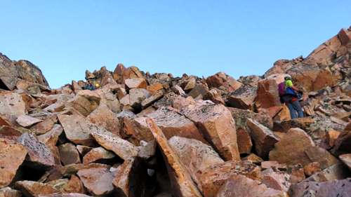
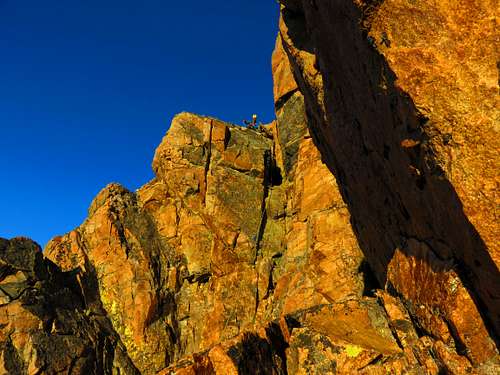
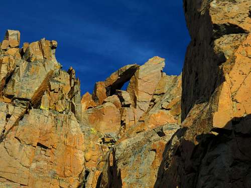
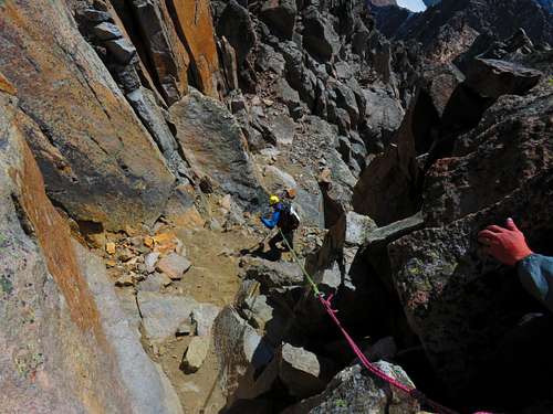
Granite - 12k campWe woke up at 3am and started our summit push at 4am. The first stage was going down a scree field diagonally to the bivvy saddle. We made quick time down-maybe half an hour. I felt like I had wings now that I had 15lbs on my back! By the time we got to the saddle, it was still dark: we rested for a good 30 minutes or so until a glimmer of daybreak. At daybreak, we started the scramble up to the snow bridge area. That was definitely the hard part of the day: the way up was steep and the rocks were loose-but not so loose as to be dangerous. We skirted the snowfields and made it up to the snow bridge, which had mostly melted out at this point. I was feeling good at this point: with the climb remaining, I knew I would make the summit. We had two rope teams, Cory and myself, Matt and Tyler. Cory skillfully led us up one pitch and another and another. The climbing was quite easy and enjoyable. Every pitch meant we were that much closer to the summit. Every pitch afforded a better and better view of the lakes, rocks and snowfields below. Cory related stories of other hikes he had done in the area: it was all fascinating! At one point we had to pull a more difficult move as we went briefly off line (Cory estimates it was a 5.9) - good feeling for sure! Eventually we hit the magic spot, the Keyhole, the gateway to the summit. After the keyhole it was maybe a 5 minute scramble to the summit!
![Granite - summit bid scree]()
Granite - summit bid scree
![Granite - 1st pitch]() Granite - 1st pitch
Granite - 1st pitch![Granite - Keyhole]() Granite - Keyhole
Granite - Keyhole
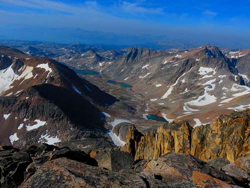
The summit was spectacular! Views in all directions.. all of Montana unfolded beneath us! And the conditions? Spectacular: maybe 45 degrees, minimal wind, sun all around: though, we could see some high clouds forming: yes, there would be some bad weather later, but for now: we had the mountain in her most welcoming state mostly to ourselves. The only other visitors at this point (it was before 9am) were a mountain goat and eventually a trail runner who had run up the summit from our trailhead in 7 hours. To put things in perspective, the record for Granite Peak was 5 hours-something; he had casually done it in 7 hours; it was our 3rd day and we had all sorts of climbing gear with us. Some people are just outer-worldly athletes! We spent a good 45 minutes on the summit. The last visitor we met was a state high pointer, who had a few drive ups left. We kept inquiring about our friends from the Air Force, who were going to be on the summit sometime today (we were not sure when), but I guess we missed them.
![Granite - happy summit group]() Granite - happy summit group
Granite - happy summit group![Granite - summit view]() Granite - summit view
Granite - summit viewGoing down the summit block involved a series of longish rappels. I admit it was quite scary: I completely forgot proper rappel technique briefly there, but quickly adjusted. The rappel was definitely the scariest part of our adventure so far. What made it scary were the awkward rocks that we had to negotiate on our way down (there was no free hang). We made good time with the rappels and were back at the snow bridge, where we could take our harnesses off. At the snow bridge, we saw a couple with no gear, no water bottle and no clue what they were doing going up the way we had climbed. What to do here? Do we tell them to turn around as it was a BAD idea? The trail runner earlier had no problems doing the same. We let them carry on and do their thing: hopefully they would be smart enough to turn around. We down climbed the steep scree field to the saddle and climbed up the diagonal scree back to our tent spot. I elected to take my time going up, savoring the last of the scree I would see on this trip.. A sighting of the cairn by our tents was a triumphant moment for me: I had done it!! Granite, peak #48 was mine!!
![Granite - rap down]() Granite - rap down
Granite - rap down![Granite - happy sight]() Granite - happy sight
Granite - happy sightI lay down for an hour or so and I could hear my teammates chatting about the hike down.. I looked up at the sky and saw gray clouds enveloping beautiful lady Granite. She had been good to us: welcoming us to touch her from close up; now she beckoned us to leave. We packed up our things and started the trek down. Our plan was to get back to around the 10k or so mark and set up a camp somewhere in the meadow below (past the scree). The hike down proved initially easy, as Cory had found us a great line that avoids the nasty scree, but eventually we went too low down the plateau and found ourselves in some deep scree. At this point I was pretty tired and had to walk gingerly over the rocks so as not to get hurt. My teammates were much quicker and had already located a camp site and set up tents. I was so grateful when I saw their tent in the distance. It meant my date with scree was over!
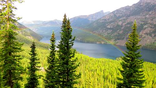
The last day of the hike was also my birthday. And what a gift to have done such a beautiful trek with friends and to have visited such a worthy mountain! I woke up to the sound of rain pattering on my tent: oh oh… we scrambled to get our stuff together and head out to the trail. Once we got to the trail, I didn’t care if I got soaked. Miraculously, the weather started improving as we rounded the hairpin turns on the trail: there was even a rainbow over Mystic lake briefly! By the time we got back to our truck, the weather had improved substantially: it was even hot and sunny. The last few steps were hugely satisfying for me. Here is to more fun backpacking trips and more peaks! And the final tally: I'm guessing here but maybe 26 miles round trip and about 9000' vertical.
![Granite - leaving FTD]() Granite - leaving FTD
Granite - leaving FTD![Granite - rainbow for good luck]() Granite - rainbow for good luck
Granite - rainbow for good luck


Comments
Post a Comment