
|
|
Trailhead |
|---|---|
|
|
38.04794°N / 119.26319°W |
|
|
Mono |
|
|
Summer, Fall |
|
|
9800 ft / 2987 m |
Add Heading here
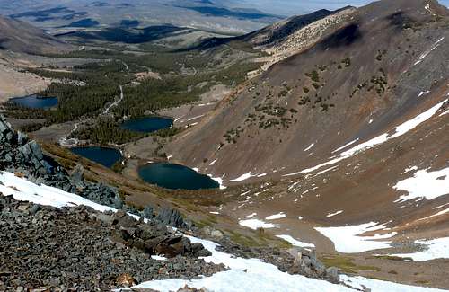 View on the descent back to the Virginia Lakes Trailhead
The Virginia Lakes Trailhead is perhaps one of the best hiking areas in all of California. Numerous summits can be reached from the trailhead. It is situated at 9,800’, which is high by Sierra standards. While all of the accessible peaks are less than 12,500’, the sheer beauty of the area is awe inspiring.
To reach it you need to get to Conway Summit 8,143'. From the north from Bridgeport, California head 13 miles south on Hwy. 395 to Conway Summit. From the south, head about 13 miles north from Lee Vining to Conway Summit, passing Mono Lake on the way. At Conway Summit head west on Virginia Lakes Road, and head 6 miles (west) to the trailhead at roads end.
There is no cost for parking and day hiking. Overnight camping can be arranged with the Bridgeport Ranger District. There are more details on the individual mountain pages.
External Links
Bridgeport Ranger District
Virginia Lakes Trailhead