Background
![Lucho, Ready For Guard Duty]() Lucho, Ready For Guard Duty
Lucho, Ready For Guard Duty
In December of 2007, after we had done our Seven Summits, Nathan stayed for about a week after Smiley went back to the States. He managed a solo climb of Ubinas between storms and eruptions. I was too tired to do another mountain then but it was on Smiley's list when he came back this year so I got another opportunity to climb it. After getting a window busted out on the van during an attempt on Cerro Horgueta the day before, I decided we better have someone with us to watch the van this time. My friend Lucho always likes to get in on our climbing adventures, so he agreed to go with us.
Getting There
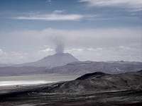
![A View of Ubinas]() Follow the Road Between the Lake and the Hill On the right
Follow the Road Between the Lake and the Hill On the right![Turn Here for Pichu Pichu and Ubinas]() Turn Right Here Going Past Pichu Pichu
Turn Right Here Going Past Pichu Pichu![Take the Road On the Right]() Take the Road On the Right
Take the Road On the Right![We Took the Road On the Right]() We Took the Road On the Left
We Took the Road On the Left
Saturday, after spending the morning getting the window replaced, we got a bit of a late start for Ubinas. The road starts out the same as for Pichu Pichu, going through Chihuata, which is the end of the pavement, and then a miserably rough gravel road around the north end of Pichu Pichu to Lagunas Salinas, which is just a salt flat at this time of the year. To make it worse, we drove in dense fog/light rain for a couple of hours until we got to the flats near the lake. If finally cleared up and we could see Pichu Pichu and Ubinas. When we got to Moche, a small village on the edge of the lake, Lucho got directions to the trail head at Ubinas. I was glad he was with us because I didn't understand the directions and we were supposed to stop at the next little village and to get additional directions about an obscure turnoff to the trail head.
We met a man coming towards us on a bicycle so Lucho asked him about the road. He said the directions we had were too complicated and hard to follow, especially now that it was dark. I wasn't really sure what was happening but soon they were tying his bike on my roof ladder, and he hopped in the van, along with a large container he had been carrying on his bike. Lucho explained that he was going to show us an easier and shorter way. We turned around and went the way we had come from for about 15 minutes and then the man asked for a piece of paper to draw us a map. We were at his house and he was getting out, but said it was right on the way to where we needed to go. It was a moonless night so we could no longer see Ubinas, but followed his map for over 30 minutes, looking for our turnoff. We were beginning to wonder if we had missed it so I finally stopped and got out to see if we could see Ubinas anywhere. With the car lights off, we could just barely see the outline of the mountain ahead of us by the starlight!
Encouraged that we were on the right track, we went a bit farther and found our turn that would take us around to the other side of the mountain where the trail head was supposed to be (The road we had been on goes by the mountain to the village of Ubinas). Now we were supposed find a small jeep trail turning off the “road” we were on, which was itself just a jeep trail meandering around the rocks. After one false turn and a couple of more stops to get out and look for the mountain, we finally found the right trail. (This would be easy to see in the daylight, as it goes right towards the mountain) We soon came to a steep hill that was very loose sand. Even with four wheel drive, it didn't look good for going up at night, so we turned around and went back to a flat place we had just passed. We decided to camp there at about 15,100 ft. (about six hours after we left Arequipa) and see exactly where we were in the morning.
Up To the Crater Rim
![Ready To Climb, Just After Sunrise]() Ready To Climb, Just After Sunrise
Ready To Climb, Just After Sunrise![Just Past the End of the Jeep Road]() Just Past the End of the Jeep Road
Just Past the End of the Jeep Road![Smiley On the Crater Rim]() Smiley On the Crater Rim
Smiley On the Crater Rim![Looking Into the Crater]() Looking Into the Crater
Looking Into the Crater![This Is the Traverse Around To the Right]() This Is the Traverse Around To the Right
This Is the Traverse Around To the Right![Looking Down]() Looking Down
Looking Down
We awoke to a clear view of Ubinas, the base of the mountain was just above a low cliff near us, which was where the sandy hill was that stopped us the night before. It was a very welcome sight after our confusion in getting there in the dark. We decided not to try to drive any farther and started hiking up the road at 6:12 am. A half hour later we were at the end of the jeep trail at about 16,200 ft., and started climbing up a low sandy hill. A few minutes later we were at a low ridge and from there could see a faint use path zigzagging up a rock strewn sandy ridge up to the crater rim.
At 8:35 we reached the crater rim at 17,800 ft. and were treated to a spectacular view into the enormous crater. Below the rim where we were standing, was a fairly flat ledge of black sand, and then an almost vertical drop down to the depths of the crater, about 650 ft. below us. It would be possible to get down to the wide ledge but we had no desire to get that close to the sandy edge of the crater. There was lots of white smoke billowing out of the crater, with a strong sulfur smell. From there we could also see that we were a long ways from the summit. There was one peak across the crater from us, and another one about 2/3 of the way around the crater on the right side. The problem was that peak was separated from us by a very rocky traverse and numerous substantial ups and downs. However because we weren't sure which was the true summit we decided to go around to the right. It turned out to be a slow and tiring route.
Finally - The Summit
![A Little Rock Climbing On the Traverse]() A Little Rock Climbing On the Traverse
A Little Rock Climbing On the Traverse![Walking the Line]() Walking the Line
Walking the Line![Smiley On the Summit]() Smiley On the Summit
Smiley On the Summit![The Crater From the Summit]() The Crater From the Summit
The Crater From the Summit![Our Route Down]() Our Route Down
Our Route Down![This Is the Road From Chiguata Up Around Pichu Pichu]() This Is the Road From Chiguata Up Around Pichu Pichu
This Is the Road From Chiguata Up Around Pichu PichuThe false summits were right on the rim, and were steep and rocky. To avoid them would require dropping down quite a ways on the side of the volcano so we tried to stay as close to the lip of the crater as possible. At one place we ended up going down a few hundred feet to get around a rocky point, at another time we had a short 5.5 climb on dirt covered rock. We were also walking right on the edge of the crater on the narrow rim at times, as that was the easiest route rather than trying to traverse in the steep loose sand. There was a strong cold wind blowing and we were filthy from the fine black ash that was being blown around.
We reached the summit at 11:05 via a steep exposed ridge that dropped of on both sides into the crater. At that point we weren't positive if the NW peak we were on, or the farther East one, was the true summit. We didn't have a topo map for the area but the East summit looked lower. Looking
at it later on Google Maps, it looks like the other peak, on the side nearest to the road going to the village of Ubinas, is a little higher. Although the recent eruptions (starting in November 2007) blowing towards the side we were on, could have made that higher.
We spent about 20 minutes on the summit and then started back around the rim. Before reaching our ascent route, we came to a large gully that was mostly black sand among large rocks, so we made a rapid descent down that to the road. We were back at the van at 1:30 pm and after eating some lunch headed back around the mountain. It was so much easier now that we could see the mountain and the roads. I also got photos of the road signs on the way out. I think we were back in Arequipa in about four hours.


Comments
Post a Comment