-
 507 Hits
-
 75.81% Score
-
 6 Votes
|
|
Mountain/Rock |
|---|---|
|
|
38.81631°N / 119.84267°W |
|
|
Alpine |
|
|
Hiking |
|
|
Spring, Summer, Fall |
|
|
9367 ft / 2855 m |
|
|
Overview

Southeast of the Freel Peak massif lies a series of smaller ridges and rises. These are separated from Freel and Jobs Sister/Peak by Horsethief Canyon. Few of them are named summits (outside of some permutation of "Peak ####"). The notable one here is "Wade Benchmark" - sometimes erroneously referred to as "Wade Peak" on topo maps.
Wade Benchmark is not a GNIS-recognized peak. Its name comes from being used as a USGS benchmark for surveys of Wade Canyon to the southeast, through which CA88 passes near Woodfords and Alpine Village.
Unsurprisingly, Wade Benchmark is a remote and undistinguished northern Sierra summit. While other obscure Tahoe-area peaks like Mt. Mildred and Snow Mountain are distinct peaks or have sights and sounds along the approach, Wade Benchmark is pretty much neither. So - why climb it? Lists, of course! Wade Benchmark is part of the Tahoe Ogul peakbagging list of 63 mountains.
Why was Wade Benchmark added to the list? That's actually a good question - in conversations with members of the Western States Climbers Executive Committee (which maintains the list), a lot of that information is pretty much lost to time. 1970s members of the Sierra Club's Peak and Gorge Section identified the Tahoe Oguls as mountains that one could access in a day's drive from the Section's base in Sacramento. When the list was made, a member proposed an addition and a majority vote resulted in its inclusion. The Section disbanded in the early 1990s, and unfortunately minutes for these decisions weren't kept.
So, Wade Benchmark might not be the hottest mountain out there (unless you visit in August) - but it's still a good one for getting people to unknown mountains that are very, very much out of the norm for northern Sierra peakbagging/hiking.
Getting There
Wade Benchmark is best accessed from the south via the Horsethief Canyon Trailhead off of CA88. To get there, drive approximately two miles east of Hope Valley through Sorensens, or drive four or five miles west of the intersection of CA88 and CA89 near Woodfords. The trailhead/parking area is to the north. It is a large dirt area with plenty of room.
Route

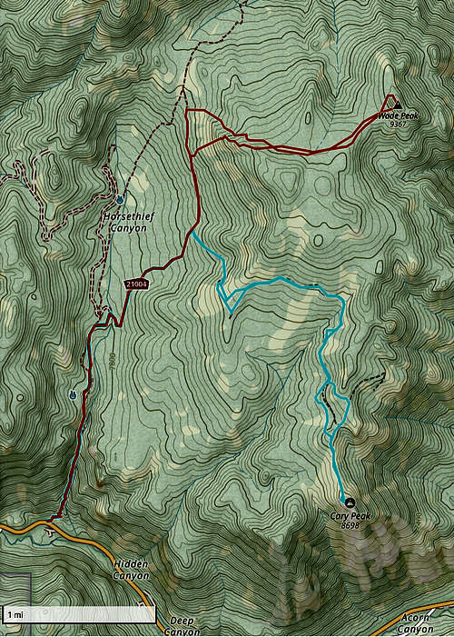
Wade Benchmark is uniformly hiked from Horsethief Canyon. It is approximately 10 miles round-trip. When leaving the trail, hikers will encounter some moderate bushwhacking and a low-difficulty talus summit block.
- Head north up the Horsethief Canyon Trail from the parking area. This is the steepest section, gaining around 1000 feet in a mile. After about 1.5 miles from the start, the trail passes an intersection and crosses east over Horsethief Canyon.
- Continue heading northeast for approximately two miles. The trail is of quite good quality. To the east, you'll start seeing steadily steeper slopes that lead you to Wade Benchmark. Resist the temptation to climb up these; you will encounter some extremely steep and annoying manzanita. Instead, continue heading north until you encounter a glen with low brush and some scattered trees, approximately ENE of Wade Benchmark proper on topo maps.
- Turn off the trail and begin cross-country hiking. You might encounter some light bushwhacking; if it gets more than light, then you haven't headed north far enough to avoid the clumps. This northwest slope of the high point of this range (Peak 9390) is pretty kind.
- You will eventually push out of the low brush and be in a gentle valley with scattered trees. Head northeast and you'll find the talus summit of Wade Peak, which requires easy Class 2 scrambling to hit the top.
After hitting Wade Benchmark and seeing the views east into Nevada, simply retrace your steps.
Red Tape
No red tape for day hikes. Wade Benchmark lies within the Humboldt-Toiyabe National Forest. If camping dispersed, then be 100 feet away from water sources.
When to Climb
Any time, though spring, summer, and fall are the most common times for obvious reasons. The strong tree coverage around Horsethief Canyon can delay snow melt.
External Links
USFS Humboldt-Toiyabe National Forest: link.

