
-
 16212 Hits
-
 75.81% Score
-
 6 Votes
|
|
Trailhead |
|---|---|
|
|
48.28817°N / 113.60722°W |
|
|
Flathead |
|
|
Spring, Summer, Fall, Winter |
|
|
3720 ft / 1134 m |
Walton Ranger Station
 Sign on U.S. Highway 2
 The Permit Office
The historic Walton Ranger Station was constructed in 1932. In December of 1986 it was added to National Register of Historic Places.
It is from this trailhead that access is provided for reaching Scalplock Mountain and Lookout, the Ole Creek Drainage as well as serves as a "dry crossing" to reach the Park Creek Drainage.
Getting There
 Historic Residence
 The Stock Facilities
The Walton Ranger Station is located on the southwest side of Glacier National Park. This section of the park was once a bustling hub of activity but with the completion of the Going-to-the-Sun Highway over Logan Pass the number of visitors decreased dramatically.
In the past visitors primnarily rode horses through these valleys that access the few lakes and vistas.
U.S. Highway 2 between West and East Glacier weaves between the mountain in the Flathead Range to the west and the incredible peaks of the Clark Range in Glacier National Park to the East.
The highway follows the Middle Fork of the Flathead River as it forms the boundary of the southwestern side of Glacier National Park and actually passes through a small portion of the park to the East of Essex, Montana.
Walton Ranger Station is located just inside the western park boundary on U.S. Highway 2 near Essex, Montana.
Just east of the park U.S. Highway 2 follows Bear Creek to Marias Pass. Marias Pass was influential for the Transcontinental Railroad and was “discovered” by John Stephens as he searched for a rail route through the mountains.
For more information on Marias Pass see Centennial Series: A History of Glacier National Park’s Passes: Part I
Other Information:
 Trailhead Sign
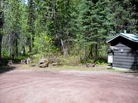 Trailhead Location
The trail leaving from the Walton Ranger Station is the part of the Southern Boundary Trail that once traveled from Walton to West Glacier. Portions of the trail have been in a state of disrepair due to not being used. This portion of the trail travels from Walton to the Park Creek Trail.
The peaks and areas accessible from this trailhead include:
Scalplock Mountain
Soldier Mountain
Sheep Mountain
Brave Dog Mountain
Trails Accessed from Walton Ranger Station Trailhead
Ole Creek
Park Creek Trail
Fielding-Coal Creek Trail
The USGS quad maps associated with this area are Essex, Nimrod, Pinnacle, Mount Saint Nicholas, and Blacktail.
 Perhaps the most depressing sign in the world.