
Comments
No comments posted yet.
|
|
Trip Report |
|---|---|
|
|
46.25068°N / 10.80079°E |
|
|
Aug 25, 2019 |
|
|
Hiking, Mountaineering, Scrambling, Via Ferrata |
|
|
Summer, Fall |
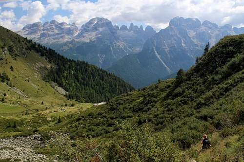
Marie and I had come to Madonna di Campiglio with a view to exploring the Brenta dolomite mountains to the east of the town. However, we were aware from the map that to the west of the town lay the Presanella group of mountains and it looked like we may be able to explore some of the popular hiking routes on its eastern fringe. Unlike the eastern side, the western side of the Campiglio valley is made of predominantly granite.
Having arrived in Madonna, we were struck by how different it was from other northern Italian towns we have visited. Noisy, expensive and quite crowded but whilst a lot of the visitors were obviously there for the mountains, there were significant groups who clearly were not. We found them wandering around the shops, sitting on blankets or playing sports in the parks every day. Consequently, the town had a strange atmosphere unlike most mountain towns. The bar opposite our hotel was open with music playing until 3 am, even though there was never anyone drinking there!
On the positive side, we were pleased to realise that our holiday package included a free “Dolomeet” card – free bus and cable car travel! So, our first excursion was to be an easy hike to the north west of the town.
We got the cable car up to the Pradalago station, it was mid-morning by the time we got going but we were in no hurry. It was a cloudy day but we were pleased to get our first proper views of the Brenta dolomites on the opposite side of the valley. However, the views didn’t last that long as the cloud became thicker.
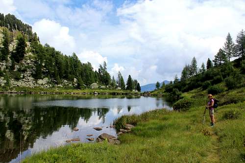
We descended towards the Rifugio Vivani and continued northwards on the path towards the Lago delle Malghette and its rifugio. For a Sunday, it wasn’t too crowded on the path although, this may have been due to the forecast of showers for the afternoon.
“We could have lunch at the rifugio by the lake?” Marie suggested as we headed upwards. I nodded, this seemed like a good idea.
After 50 minutes of walking we reached the Rifugio Lago delle Malghette and immediately changed our minds about stopping for lunch! A football crowd sized group of people were already there – there wasn’t a space to even put a rucksack down!
We got through the crowd and continued on the upward path on the north side of the lake. Soon, we had left the people behind as the path became steeper on the wooded slopes.
From this path we had occasional glimpses of the lake as we rose above it. At one of these viewpoints we met a Frenchman and said “Buongiorno” - he realised we were English speaking!
“Brexit” he exclaimed “it is a big problem!” He gave us a “thumbs down” sign.
“Yes.” We both agreed. (Don’t get me started!)
After about an hour we reached the Lago Alto just as the sun came out, so we sat on its northern shore for some lunch. It was a peaceful spot, with a pleasant view of the hillsides above the lake.
“It’s great to be back in the mountains, isn’t it?” I said knowing that Marie wouldn’t disagree.
Soon, our French friend appeared and wandered around to the opposite side of the lake.
“Is he waving to us?” Marie asked.
The Frenchmen was indeed waving and shouting out something.
“Can you hear what he’s saying?” I asked.
“Not really,” Marie said. “Although, I think he said “Buono”…good. And he’s pointing, perhaps he means the view?”
We waved back and after a while he continued on his way, heading upwards towards the Tre Laghi.
We finished lunch and walked around the lake to see what the fuss was about. The view was better but not that spectacular, perhaps we missed the point?
At 1.30 pm we had to decide what to do.
“Shall we carry on up to the Tre Laghi?” I suggested.
“No, lets head back.” Marie said. “We don’t want to get caught in the rain.
It was sunny and warm but I didn’t disagree and we set off down. Not surprisingly, it was easier descending and after 40 minutes we were nearly down to the rifugio when it started raining. The cloud had arrived from the west unseen and had covered the sun a few minutes before it rained.
“It will only be a shower.” I predicted.
I was wrong!
It poured continuously as we descended. Twice we stopped under the trees to shelter before continuing again.
Eventually it stopped and by the time we reached Campo Carla Magno at 3.30pm, the sun was out again and we dried off walking down the road back to Madonna di Campiglio.
The blue sky we had awoken to had gone by the time we were ready to set off. We changed our choice of route 3 times before settling on the ridge of Monte Zeledria which we could see from our room in the town. Again, the promise of thunderstorms later had made us wary.
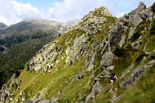
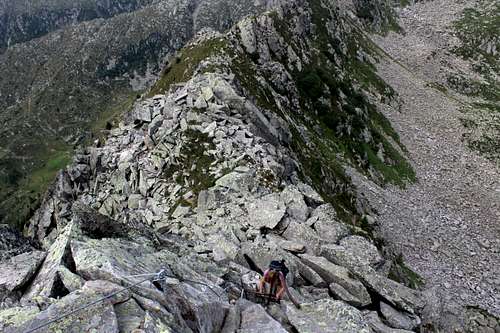
From the Pradalago cable car station we headed westwards up the ridge. This was a mixture of walking and scrambling over the granite boulders. Although this route was marked as a ferrata, we had read it was not one that we would need any ferrata equipment on and this proved to be correct.
On a fine day it would be a good objective just to enjoy the views. I had expected the route to be a popular choice as it’s so easily accessible from Madonna di Campiglio but with the exception of a couple far in the distance in front of us, we saw no-one until we had nearly completed the traverse.
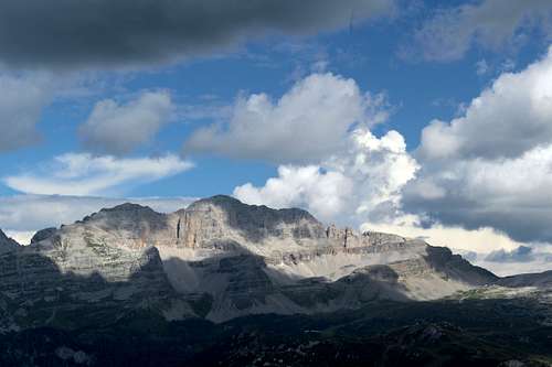
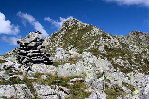
We soon reached the summit with its metal, Italian flag and stopped for the usual pictures. Once again, the Brenta were in cloud but we had good views of the mountains above us, Cima Laste (2770m), Monte Nambino (2678m) and Monte Serodoli (2708m) were all clear at that point.
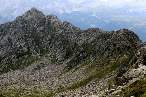
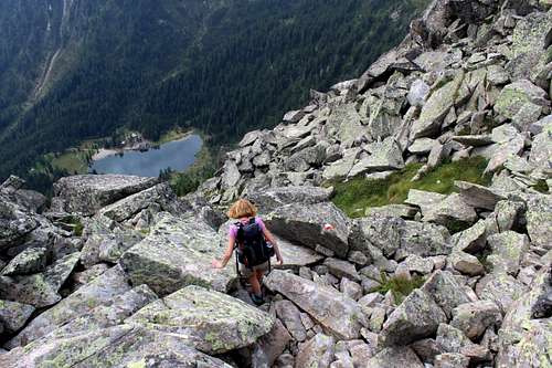
From the summit, the terrain into the mountains is quite wild looking and we were eager to continue. The ridge descends and rises on a rough path with sections of cable and ladders over the bare rock and steep sections of path over the grassy hillsides. Way below us, we could see Lago di Nambino with its large rifugio looking popular. Apart from the view of the rifugio, the scattered boulders and the grey sky made it look like we could be traversing a ridge in North Wales!
All in all, the following hour passed very quickly as we finally descended to the Boccha dei Tre Laghi, where the route crosses to the north side of the ridge for a time.
Looking upwards, the clouds arriving from the west once again, looked threatening. We hurried along the path and crossed back over to the south side of the ridge. The way continued over towards Lago Serodoli and I had an idea that we might have climbed Monte Serodoli behind it but the worsening weather and Marie’s insistence that we go down put paid to that!
|
|
From the lakeside, we descended with other hikers in the sunshine towards Lago Nero. Just after the lake, everyone else headed down towards Lago di Nambino, whilst we headed towards Malga Busa dei Cavalli where we planned to stop for some food. Just as we got there and sat down, dark clouds covered the sun and the rain began to fall.
We ate quickly and set off again upwards towards the Pradalago cable car. It appeared on the map as though we were at more or less the same altitude as the cable car station but this was incorrect. We had quite a lot of height to regain to reach the path we wanted and then traverse the south side of the Monte Zeledria ridge to reach our goal. The rain fell heavily again as we continued.
About 10 minutes before we reached the cable car, the rain stopped and almost immediately, the sun came out.
“I wonder if this will be the trend for the holiday.” Marie said.
I looked at her puzzled, “What do you mean?”
“Getting wet in the afternoon!” she replied.
I watched the rain falling heavily on Madonna di Campiglio as we stood in the sunshine and thought “Yes, I think that will be the case.”
We had completed a really enjoyable route. Easy scrambling in a fine mountain setting and a good, albeit easy summit and although it did rain on other days during our stay, that was the last time we got caught out in it.
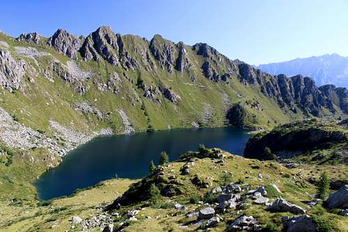
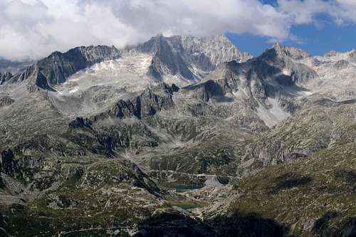
A lovely, clear sunny day found us on the cable car heading up to the Cinque Lagi Rifugio with fabulous views across the valley to the Brenta dolomites. I began to regret our decision to come this way rather than head into the higher mountains and this was only increased as we walked the short distance to Lago Ritorto in a procession of hikers of all ages.
We stopped at the lake side by the junction of several pathways and decided what to do. Marie suggested we head to the southwest and upwards on path no 278 towards Passo della Falculotta. At that moment, it looked pretty clear so we set as fast as we could before everyone followed.
We made good time up to some rocky outcrops where I wanted to get some pictures. I expected to see the hordes following us up the path but instead the path was empty. Looking across Lago Ritorto to the path up to Passo Ritort, I could see the line of ant-like figures one after another heading upwards!
We reached the Passo della Falculotta and I suddenly had an idea that maybe I could get up to a, at least a small summit from here. Marie decided to sit in the sun as I set off on my own. Had I checked the map a bit more thoroughly, I might have decided to head up to Monte Ritort, just over 100m above the pass. Instead I headed for the much further away, Pala Della Falculotta, more than 200m in height above the pass.
I started on a grassy path which wound its way between outcrops of rock, vanishing every now and then before reappearing. I was heading for what I perceived to be the top, I fancied I could see something like a cross ahead on an outcrop of rock and thought that was my summit.
It was easy going in lovely sunshine and as I got higher the views got better. Further westwards, I had a great view of Cima Presanella, an area I had never previously heard of but one that looked fantastic in the sun although, once again, I noted that clouds were drifting in from the westerly lands beyond the mountains.
Eastwards towards the Brenta dolomites, I was looking into the sun which hampered my view but I realised that Monte Ritort had a cross on the top. Looking back at my goal, the summit was looking more like it had a pole on the top rather than a cross!
At some point, I realised I was heading not for a true summit - that was much further on - but for what I think on the map is marked “Pt 2467”, a cairn with a pole adorned by old Nepalese prayer flags! Nevertheless, I continued up to it just to satisfy myself.
|
|
The last 20 feet or so involved an easy scramble to the marker. It had taken me 30 minutes to reach this point from the pass and to continue would delay us even more. I was aware that Marie was waiting for me, unsure of when I would return. After a short stop, I headed back down to Marie sitting in the sun.
“I have been photographing Frogs and Butterflies!” She said when I returned.
From here the path descended, following a natural line around and beneath the rocky ridge. Way ahead, we could see a couple descending in front of us, they had passed Marie while she waited for me. Otherwise, we had the whole mountainside to ourselves. The quality of the path deteriorated and became very overgrown as we headed towards the grassy alps at Malga Valchestria and here, we stopped for some lunch.
“This is a great walk.” Marie said as we sat eating in the sun.
“Yeah,” I replied. “The whole atmosphere on this side of the valley is different from the dolomite side. There’s a lot more vegetation here.”
The signpost told us that to return to Lago Ritorto would take 1:30 hours so we set off at an easy pace. The route started in thick woodland but soon we emerged onto an open mountainside with fabulous views across the valley to the Brenta dolomites. We made very poor time as I constantly stopped to take pictures of essentially, the same view! We tried to pick out the places we had already visited, Passo Groste was easy, the Rifugios Tuckett and Sella more difficult and the way up to the Bocca del Tuckett looked a lot steeper than it was.
Eventually, we returned to the Lago Ritorto and met up once again with the hordes. Back at the cable car station, we celebrated with beer and toasted sandwiches while we watched afternoon clouds drifting over the northern Brenta mountains.
Footnote: We ventured further into this area later in the trip. See my trip report https://www.summitpost.org/val-di-genova-day-trip/1047363 here for details.