
|
|
Custom Object |
|---|---|
|
|
51.75808°N / 3.59282°W |
|
|
Waterfalls |
|
|
Powys / Neath and Port Talbot |
Introduction:-
The Vale of Neath and its Waterfalls
Nowhere else within Wales is there such a richness and diversity of waterfalls within such a small area as can be found in the Vale of Neath. The abundance of them has led to the region becoming known as the "Waterfall Country".
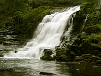
The lower Clun-Gwyn waterfall on the Mellte river
This summitpost page is a custom page covering the wooded valleys on the southern edge of the Brecon Beacons National Park and the often secret waters that they contain. There are other waterfalls in the area with much easier access such as the Melincourt near Resolven, Henrhyd near Abercraf and the Aberdulais near Neath which are also covered in this page.

The Calm before the Falls
In this region the deep gorges of the rivers Hepste, Mellte and Nedd Fechan that all join here to make the River Neath itself, between the villages of Pontneddfechan and Ystradfellte, provide great opportunities for the casual and the more experienced walkers to make a great day out discovering some of Wales greatest waterfalls within this little known region.

Plants Ferns and Mosses
The humididity created by the spray of the water along with the shade of the overhanging canopies of ancient Oak trees provide ideal conditions for many rare ferns and mosses. Look out also for birds such as Dippers which nest within crevices and cracks on the cliffs and even behind the waterfalls themselves. If you do find a nest with chicks or eggs in it, please do not touch it and do not hang around the area to long coursing the parent birds to abandon the nest.
The woodlands area is owned by the Forestry Commission who, with help from the National Park and other authorities such as the National Trust and the local councils keep this area maintained.
Getting There:-
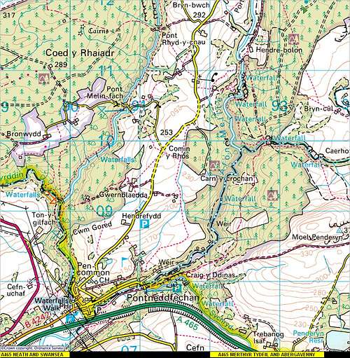
1:50.000 OS Map for the Waterfall Country
Getting there is very easy...
The main village of Pontneddfechan is on the A465 known as the head of valleys road, which can be accessed from Merthyr Tydfil in the east and Neath and Swansea in the west.
Merthyr Tydfil can also be accessed from north and south on the A470 from Cardiff which has links with the M4 from England. The A470 also has access from most areas of central Wales. Neath can be accessed from the M4 motorway giving access from west Wales and Swansea.
The best places to start your walks from for the Hepste and Mellte are the Gwaun Hepste car park just off the A4059 about a mile north of Penderyn village.
Or the car park near the bunk house centre between the villages of Pontneddfechan and Ystradfellte.
Safety - Access and Red Tape:-
ACCESS AND RED TAPE (CAUTION READ WITH DETAIL FOR YOUR OWN SAFETY)
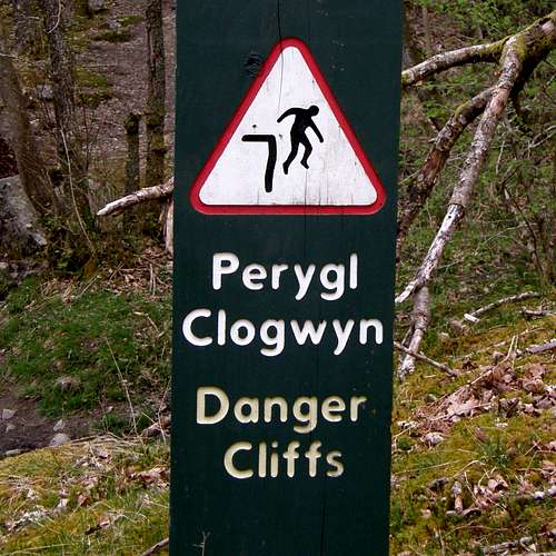
There are many dangers in these valleys. Deaths have happened
The routes around some of these waterfalls can be very dangerous. The less fit are not advised to attempt them. The way marked paths should be kept to as straying off them exposes shear cliffs and slippery rock surfaces above the gorges of the rivers.
Also please dress sensible stout good walking boots and waterproofs are advised and be aware of the many dangers involved especially if the weather changes. Heavy rain can make the paths even more dangerous.
I spent just two days waterfall spotting in the 2008 May bank holiday weekend and some of the behaviour I saw shocked me. Parents letting there children run about in trainers on slippery rocks around cliffs and behind the waterfalls, young lads wearing flip flops and girls wearing flimsy Croc’s moaning about the path being rough. In fact one girl in her Croc’s slipped on the rocks and grazed her foot. A group of youths had a disposable barbecue and not knowing that my mate and I were downstream at the next waterfall chucked the barbecue and all the barbecue rubbish in the river.
You should respect this area as getting the rescue services to it is not easy. Exposure to the cold water can also course Hyperthermia which can kill and believe me even in the hottest summer months this water is fresh of the Brecon Beacons and is still ice cold.
JUST BE SENSIBLE FOR SAFETYS SAKE…!
EMERGENCIES
Emergency phone situated at Cwm Porth Car Park.
Public phone boxes are situated in the villages of Ystradfellte, Pontneddfechan, Penderyn and at the roadside just west of Sgwd Clun-Gwyn.
Mobile phone coverage is patchy within the gorges but is normally available out on the upper hills.
For walking, rock climbing or caving accidents call 999 first requesting the Police.
For forest, woodland and heath fires call 999 requesting Fire.
In emergency situations make sure you can give as much information as accurate as possible to where you are, the situation in hand and anything else that will help them get to you or the casualty as quickly as possible.
ACCESS AND RED TAPE
The farmers control alot of access on the upper levels of farm land so stick to the dedicated bridleways and paths but when in the gorges and valleys the Brecon Beacons National Park has introduced an open access free to rome scheme which i think is great for all of us who enjoy the countryside.
Just remember though straying from the paths in the gorges can still be dangerous...!
The signs to look for concerning open access are as follows:-
Open Access Land Left - Non Open Access Right
 |
 |
The geography of the area - Creation of waterfalls:-

Hard wearing millstone grit
The creation of these waterfalls is due to differential erosion of soft rock strata found together in the river bed. Where movement in the earths crust has caused faulting, or glacial erosion has exposed the softer underlying rock strata to the erosive forces of the river, it cuts deeper and quicker into the softer rock creating a drop in the water levelling and therefore boosting the erosive powers of the water even more.
The Vale of Neath region consists of extremely hard, erosion resistant rocks like millstone grit and old red sandstone which overly bands of much softer fissured carboniferous rocks such as limestone, shale and mudstone. When the water finds its way into the joints of these rocks and what is known as the bedding planes of the harder rocks exposing the limestone, shale and mudstone, the water soon takes its toll on these softer rocks which then deprive the harder rocks of support coursing them to collapse.
The Hepste and Mellte waterfalls:-
The walks to these rivers are not easy and are often very steep and slippery. They should be attempted only by those who are suitably equipped and it is recommended visitors use the way-marked advised paths.
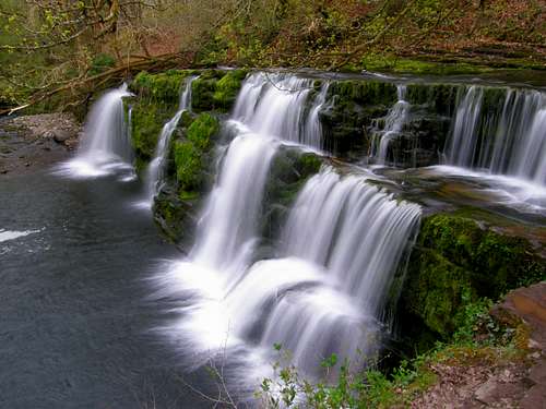
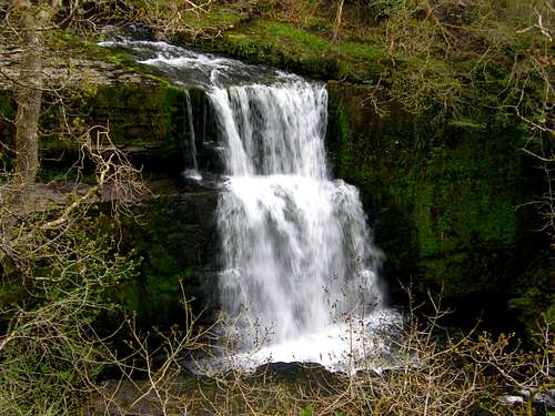
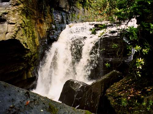
The Mellte has three great waterfalls within relatively easy walking distance from the car parking area on the minor mountain road between Pontneddfechan and Ystradfellte. Parking here the walk first leads you deep into the Oak covered gorge with the Upper, Middle and Lower Clun-Gwyn waterfalls (otherwise known as Sgwd Clungwyn and Sgwd y Pannwr). The three large waterfalls here all have different character and make a great walk but at least 3hours should be allowed for covering all the falls as its surprising how time runs out when your mind is occupied and the scenery round these waterfalls does exactly that.
The Hepste has the great waterfall of Sgwd-yr-Eira which is an overhang at the end of a horseshoe shaped sandstone gorge. The waterfall here can be walked behind but care must be taken due to the damp and slippery rocks.
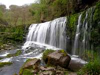
Pictures of waterfalls from the Mellte river:-
 The impressive double drop of the Upper Clun-Gwyn Waterfall
 From the side |
 From the front |
 From the cliffs |
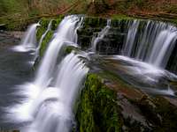
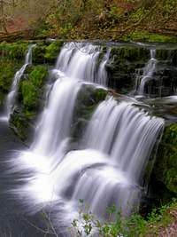
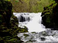
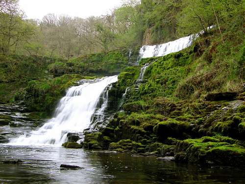 The combined Middle Clun-Gwyn Waterfall consisting of the upper and lower sections
 The upper section |
 The lower section |
 Fast drop intermediate |
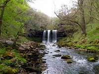
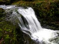
The very elegant looking Lower Clun-Gwyn waterfall taken on a 1-Second exposure
 A closer shot |
 A vertical shot |
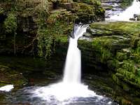
Pictures of waterfalls from the Hepste river:-
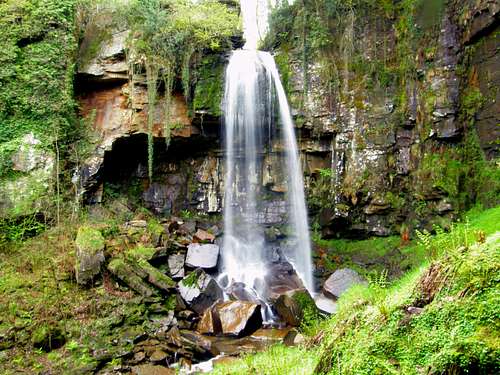
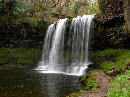 The amazing Sgwd Yr Eira Waterfall
 View from the gorge |
 From behind the falls |
 Waterfall and cliffs |
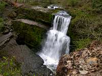
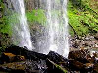
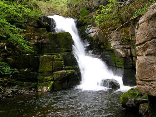 The Lower Cilhepste waterfall on the Hepste river
 Intermediate rapids |
 Intermediate waterfall |
 The top of Cilhepste |
The Melincourt - Henrhyd and Aberdulais waterfalls:-
MELINCOURT:-
The Melincourt waterfall stands at the end of a wooded gorge in a reserve run by the Glamorgan Wildlife Trust. I t is easily reached by a well defined footpath from the B4434 Resolven to Tonna road, 1 mile south of Resolven. The entrance to the path is opposite the road from the public car. There is a map and information board giving details of the reserve and the waterfall along with nature that thrives in the environment.
The Melincourt is a spectacular waterfall dropping over a shear cliff 80 feet high on a tributary river of the Neath known as Melincourt Brook. The waterfall is also famous for being painted by Turner in 1794. The reserve in total covers 12 acres of upland broad-leaved woodland which ascends steeply from the narrow gorge of the Melincourt Brook. The woodland here consists mainly of mature oak interspersed with silver birch, wild cherry, rowan and crab apple. Along side the brook trees such as alder grow along with many ferns and mosses. In spring the woodland floor is carpeted with bluebells when enchanter’s nightshade takes over later on in the summer months.
HENRHYD:-
The Henrhyd waterfall is much like the Melincourt in its geography and the nature that thrives within the area. The waterfall is owned and cared for by the National Trust and access is from a car park at the top of the gorge on a minor road just to the east of the village of Abercraf. The waterfall is signposted from the main A4221 road just east of Abercraf in the village of Coelbren. The waterfall hear is an amazing 90 feet high and can be easily walked round the back of in a vast open arena under the canopy of the waterfall. The path from the car park takes you down a steep descent through oak and ash tree woodlands to a lower path that is level with the river. Here the path then turns back on itself at the lower level and takes you across a wooden bridge that when on the other side of the river leads you to the waterfall.
ABERDULAIS:-
The Aberdulais waterfall is one of the most famous waterfalls in South Wales and has much association with artists, writers and travellers from all over the world. This is again National Trust property and offers a unique blend of natural beauty and social history all in one. Discover the secrets of this beautiful wooded gorge and how the waters of the Aberdulais waterfall powered a succession of industries for over three hundred years.
In 1584, Wales first copper smelting works was established along the banks of the Dulais river, by the Mines Royal. Like later industrialists, they were attracted here by the plentiful supply of of water for powering the waterwheels. By the 1750’s Aberdulais waterfall had been transformed; a large grist and floor mill was built to supply the local growing markets. It was in this period that the property became popular with landscape painters such as J.M.W Turner who’s work has been reproduced and is on display in the museums information centre. Today though the ivy clad ruins here remind us of the final industry – the manufacture of tinplate from the 1830’s.
It was in 1990 the National Trust embarked on its ambitious project of power generation and as part of the museum visitors can now see a waterwheel which generates the electricity to run the property. There is also a turbine generating and exporting excess electricity into the local Swalec electricity distribution.
This is a truly historic site and is worth a visit. A fee is charge to visit the waterfall and museum but the money is of course ploughed back into the National Trust. Those with a National Trust membership get access free.
Pictures of the Melincourt - Henrhyd and Aberdulais Waterfalls:-
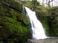
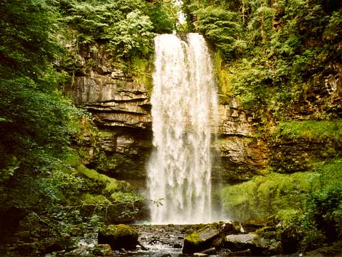
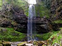
 The impressive 80 feet single drop of the Melincourt waterfall
 Walking behind the falls |
 Under the cliffs |
 From the stream |
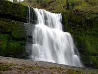
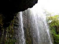
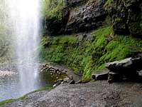
 The impressive 90 feet single drop of the Henrhyd waterfall after rain
 Waterfall splash-pool |
 Walking behind the falls |
 After a dry season |
 The Aberdulais waterfall seen from the viewing area
 |
 |
 |
 |
Local accommodation and useful links:-
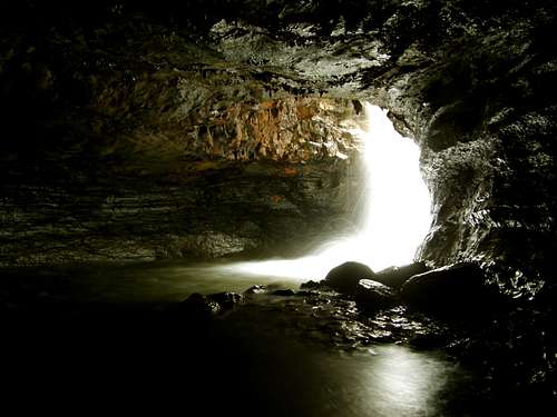
A waterfall that falls via a shake hole to its splash pool within a cave near Abergavenny
If you are in a large party of people and want to stay right in the heart of the Waterfall Country region next to the Clun-Gwyn falls you can stay at the following place.
Clyngwyn Bunkhouse Wales
This can accomodate up to 15 people for more information follow the link.
The main towns nearby for bed and breakfasts are as follows:-
Abergavenny, Merthyr Tydfil, Neath and Swansea are all on the head of the valleys road.
Information on services are as follows:-
Abergavenny
Abergavenny Bed and Breakfasts/Hotels
www.ukcampsites.co.uk Abergavenny Area
www.brecon-beacons.com (Youth Hostels and Bunkhouses in the Brecon Beacons National Park
Merthyr Tydfil
Merthyr Tydfil Bed and Breakfasts/Hotels
www.ukcampsites.co.uk Merthyr Tydfil Area
Neath
Neath Bed and Breakfasts/Hotels
www.ukcampsites.co.uk Neath Area
Swansea
Swansea Bed and Breakfasts/Hotels
www.ukcampsites.co.uk Swansea Area
Other local towns with easy access to the area are as follows:-
Brecon and Llandovery.
Brecon
Brecon Bed and Breakfasts/Hotels
Brecon Beacons National Park - Camping
Llandovery
Llandovery Bed and Breakfasts/Hotels
www.ukcampsites.co.uk Llandovery Area
Of course if you cannot find anything from the links above just use a search engine such as GOOGLE put your place and your subject B&B, Hotel camping etc and you should get a result from there.
OTHER USEFUL LINKS:-
Lots of Brecon Beacon National Park related information can be obtained from the following links.
Brecon Beacons National Park home page
Brecon Beacons National Park information
Local Councils
Powys County Council
Neath and Port Talbot Borough Council
Neath and Port Talbot council information on waterfall walks
Waterfall Walks
The National Trust
National Trust
Lots more information can be obtained from search engines. I have attached the ones I think may be of use.
There Will Be More:-
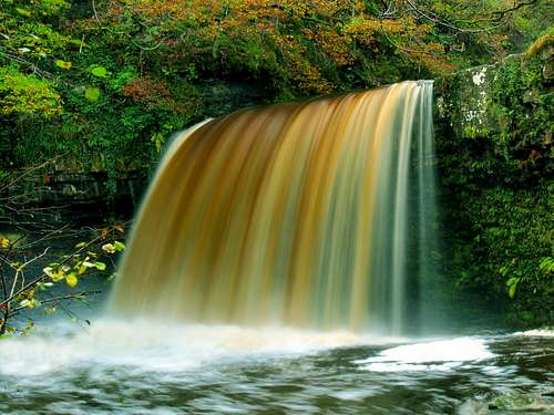
This here is the Sgwd Gwladys or known also as the Lady Falls on the Pyrddin river after a heavy autumn downpoor
The picture here says it all:-
Another trip is required to this region so I can add the waterfalls of the Nedd Fechan and Pyrddin rivers. On the Pyrddin river is the great waterfall of Sgwd Gwladys to the left here and another local well hidden but very impressive waterfall where a pair of waders may be needed for the amount of river crossings involved is the Sgwd Einoion Gam. Other falls on Nedd Fechan are smaller ones such as the Horseshoe Falls.
I shall dedicate most of my next Beacons holiday to waterfall spotting so as to finish this page.
Thank you if you have read through and enjoyed the contents of this page and taken the time to vote.
Standing behind one of the waterfalls:-
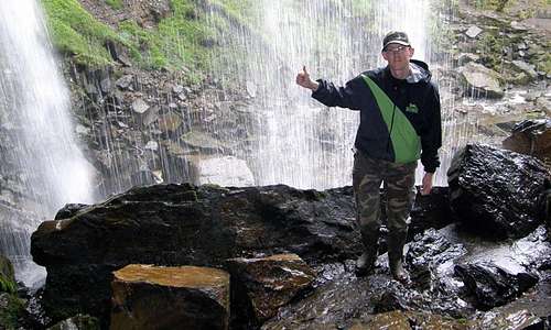 Standing behind the Melincourt Waterfall