
|
|
Route |
|---|---|
|
|
40.76500°N / 110.135°W |
|
|
Scramble |
|
|
Most of a day |
|
|
Class 2+ |
|
|
Overview
This is the shortest route to West Clover Mountain, but it may not be the easiest route (the route from from the south from Pole Creek Lake and then the Rock Creek Lakes looks easier on the map).This route climbs either the northeast or east ridge of the Clover benchmark then follows the ridge west to the. From the West Fork Trailhead, you actually cross some rough logging roads. If you can find the beginning of the roads, you can probably shorten the hike with a 4wd, but I didn't try driving them, or using another trailhead, since I didn't know they existed until crossing them on the way to the peaks.
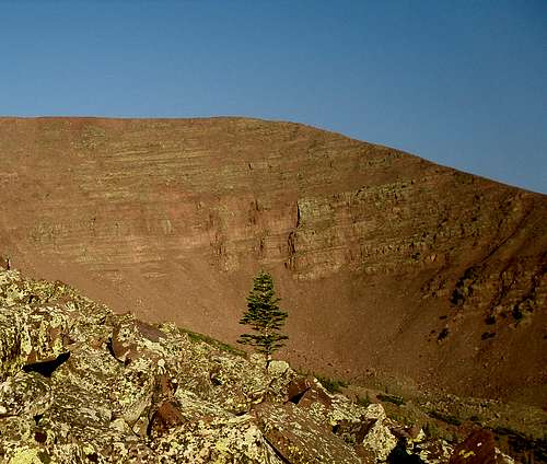 Clover Benchmark (12335') viewed from the east.
Getting There
There are several driving routes to the trailhead, but this is the quickest. A good road map is needed.From Roosevelt, take State Highway 121 north. This is where the elbow in Highway 40 is, right downtown, so the turnoff is easy to locate. Stay on Highway 121 north, follow it as is makes a sharp turn at Neola and heads due east. The highway will reach a "T" and turn south. At the "T", turn left (north) to the town of Whiterocks. From Whiterocks, drive northwest along the paved road. Not long after passing the fish hatchery, will be another junction. Go straight (not left). The road heads north, then east, then north again. At the next intersection, go straight and to the Elkhorn Guard Station.
Turn left and continue on the Elkhorn Loop Road, up Pole Mountain, and to Forest Road 110 before heading to Pole Creek Lake. Don't take the Elkhorn Loop to Pole Creek Lake, but turn right onto Forest Road 110. If you reach Pole Creek Lake, you overshot the turnoff. Follow Forest Road 110 north for about four miles to the signed (for West Fork Whiterocks Trailhead) turnoff to the left. Turn left to the trailhead. Most of the Elkhorn Loop as well as Forest Road 110 is gravel, but usually in good condition for cars, provided you drive slowly.
There is actually a rough logging road(s) that will bring you closer to the mountain. They aren't on the map, so if you wish to drive them, you will have to search for the beginning of them on your own. Also note, that this information is from the summer of 1992, and the status of these roads may have changed.
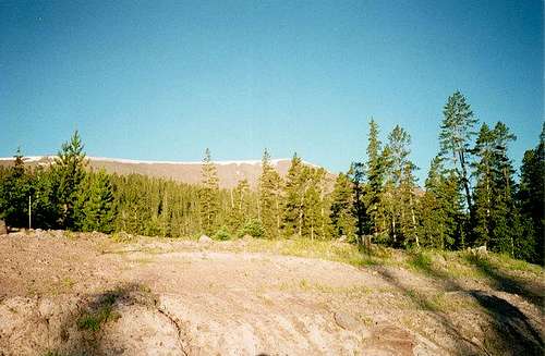 "West Clover" from the West Fork Whiterocks Trailhead.
Route Map
 Click the map for full size.
Route Description
From the trailhead, head west with a compass (or GPS). The route is a bit tedious because of fallen logs and such, but there are no real difficulties. You will cross one or more rough logging roads along the way. If you can find the beginning of the roads, this would likely be an easier alternative than the route described assuming you have a 4wd.There are two alternate ridges to climb to get to the Clover BM. The ridge I climbed is marked in red. My approximate route is marked in red; though I didn’t follow the logging road since I didn’t know where it was going (older maps did not show the logging road, but following it will save time).
SP member Zee Jay took the route marked in yellow. The yellow route sounds gentler and although slightly longer, might be just as fast (or faster).
If taking the Red Route, climb the ridge which has some very steep slopes to skirt at first, but once on the ridge it gets easier. There is a bit of scrambling/boulder-hopping. Continue up the ridge to the very broad and flat summit of Clover benchmark, marked with a cairn. The Yellow Route will join up with the Red Route here.
From Clover benchmark follow the broad ridge west over a minor summit and to the summit of "West Clover". There are some nice views, especially to the north.
"West Clover" is about 9 miles round trip from either ridge and takes most of a day to climb for most climbers.
Note: Apparently a blowdown storm has effected the routes through the forest to timberline on West Clover (according to the other summit log). It wasn't there in 1992 or in August 1995, but on Flat Top Benchmark (south of Emmons) we found one in August 1997 that caused route problems. It was probably the same storm, and it must have happened sometime between those dates. Other climbers have reported no such blowdown, so it must be in just a localized area.
 Northeast Ridge of Clover BM as seen from the East Ridge.