
-
 3664 Hits
-
 83.1% Score
-
 16 Votes
|
|
Route |
|---|---|
|
|
43.85170°N / 114.5808°W |
|
|
Scrambling |
|
|
Spring |
|
|
Most of a day |
|
|
Moderate Snow Climb |
|
|
Overview
 West Face Snow Gully
Like many of the mountains in the Boulders, Easley Peak has more than its fair share of scree to slow down would-be climbers. Fortunately there’s a hidden gem of a route that angles up the west face of the peak and allows for an obstacle free spring snow climb. The route provides nearly 2000 feet of elevation gain up a gully that has been scoured free of trees. It’s a moderate slope that would suitable for most beginners who are just learning to travel with crampons and ice axe. It starts out gentle, and gets gradually steeper the higher you get, before max’ing out at about 45 degrees near the top of the gully. This route wouldn’t be a good choice during summer or fall due to the scree, and avalanche danger makes it a good area to avoid during much of the winter. So early spring is the best time to climb the gully.
Credit to Splattski for finding this route on a hunch.
Getting There
 Approach View
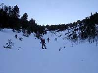 In the gully
From Ketchum, drive north on Highway 75 for about 20 miles until you reach the Owl Creek pullout. The pullout is on the left (west side of the highway) and is plowed free of snow during winter, since locals snowshoe or Nordic ski in this area. The south face of Easley is visible from the highway about a mile before your reach the pullout.
Route Description
From the Owl Creek pullout (elevation 7000’), weave to the east through the trees, and make your way up the King Creek drainage that separates Easley Peak from Cerro Ciento. Continue up the drainage, aiming for the saddle that lies between the two peaks. You won’t be able to see the west face gully until you reach about 8800 feet elevation. At that point, its time to put on crampons and begin the climb up the gully. The lower portion is gentle, but the slopes get gradually steeper the higher you get. After nearly 2000 vertical feet of climbing, the gully reaches a maximum slope of about 45 degrees just before it reaches the south ridge a few hundred feet below the summit. The remainder of the climb is a fairly gentle ridge walk to the highpoint.- Distance (one way): 3.1 Miles
- Elevation Gain: 4000 Feet