Getting There
That dirt road into Robbers Roost is awful. The entire time I was thinking "This canyon had better be worth the crap we're putting this car through". Honestly, the washboards are just terrible. My older brothers and I had just spent four days 4-wheeling in Canyonlands, and this was our relaxing warm-down. Neither me nor my brothers have a lot of canyoneering experience, which is why we chose the two easiest forks of Bluejohn. I have slightly more experience than them, and I'm the only one who knows how to navigate using a map and compass (although this would later prove to be questionable), so I was the leader of this expedition. It would have been fun to do the main or east forks, but I have little/no experience with anchors, so whatever we did could not require rappelling. Anyway, we arrived at the "alternate trailhead" around noon and set out at a quick pace along the four-wheeling track that leads to the west fork drainage.
The West Fork
![Climb into West Fork]() Downclimb
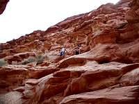
Downclimb![Deeper...]() Looking down-canyon
Looking down-canyon![West Fork]()
It was not difficult locating the correct canyon, as it is the first drainage you cross as you follow the ancient 4x4 path from the trailhead. We dropped into the canyon (which at this point is merely a wash) and headed east at a quick rate. The wash slowly got deeper and deeper and the scenery got better as we moved east. I can imagine this would be an unbearable slog in the summer, but that day it was about 75 degrees and perfect. About a mile in we encountered two hikers, which would end up being the only people we would see the entire day in the canyon. After about 45 minutes of following the drainage we arrived at the drop-off, a 30-40 foot cliff which many choose to rappel. I had good beta, so I immediately began looking for the bypass on the right. It took only seconds to locate the route down the zig-zagging ledges, and it took just under a minute to descend it. From this point the West Fork looked rather exciting. The first 2 minutes of the West Fork narrows were fun and challenging, but the slot only lasted fifty feet or so. The canyon was still very beautiful, but it was not as intense as I had hoped.
The Slog
I don't mean to say that the West Fork isn't beautiful, but as we winded our way toward the confluence we really hoped we would get some better slot action in lower Bluejohn. We enjoyed the views of the main canyon as we made our way north toward the lower slot. The hike was not strenuous (it stays almost completely flat), but the sand is always annoying. It took about 45 minutes to reach the "s-log" after leaving the west fork.
Lower Bluejohn
"Between a Rock and a Hard Place" is one of my favorite books, and I have to admit that I loved "127 Hours", so it was quite stunning to arrive at the entrance to Lower Bluejohn. We took turns taking pictures at the S-Log, then one by one dropped into the canyon. We were thoroughly enjoying ourselves within minutes, as the lower slot provides interesting downclimbs and fun obstacle avoidance. I knew the accident site when I saw it, and needless to say it was quite shocking to be standing in the place where it all happened. Of course, there was no evidence of the struggle, but it was still a surreal experience. We continued heading down-canyon, and the slot becomes very beautiful as it gets darker and deeper. The canyon was not very challenging, but still interesting and fun. Soon we arrived at the Big Drop, which provided great scenery and another surreal moment. After chilling there for a few minutes we re-ascended the canyon. The climbing was not difficult, only slightly slower than going down.
![The S-Log]() The "S-Log"
The "S-Log"![Bluejohn Canyon]() Chockstone
Chockstone![Lower Bluejohn]() The boulder
The boulder![The slot opens up...]() Light at the end of the tunnel
Light at the end of the tunnelGetting Out
After climbing out of Lower Bluejohn we were faced with the long walk back to the car. My plan was to climb out of the canyon just after the confluence of the west and main forks, then to follow the rim of the west fork back to the 4x4 road. My big mistake occurred when I led us out of the canyon at the confluence of the
east and main forks, something I wouldn't realize for half an hour. So we were forced to follow the rim of the main fork back south until we could cross it, then we made our way north-west to the trailhead. This little detour added an extra 1 1/2 hours to our trip. Needless to say my brothers were not pleased. But all in all the day proved to be enjoyable, the whole thing taking about five and a half hours to complete. Lower Bluejohn is very pretty and very cool to see, and this is an ideal route for anyone without rappelling equipment. Don't get me wrong, you should not go unprepared; it is necessary to have maps, beta, equipment for a 10-mile hike, and at least some prior canyoneering experience. With all these things this can be quite an enjoyable canyon.
Comments
No comments posted yet.