
-
 17510 Hits
-
 72.08% Score
-
 2 Votes
|
|
Trailhead |
|---|---|
|
|
38.11170°N / 107.5532°W |
|
|
Hinsdale County |
|
|
10780 ft / 3286 m |
Getting to the West Fork Valley
The West Fork of the Cimmaron River is a beautiful area that provides access to the northwest corner of the Uncompahgre Wilderness via Forest Road 860. Forest Road 860 is accessible from the west from US Highway 550 and from the north from US Highway 50.From US Highway 550 to the west, turn east on Owl Creek Pass Road (Ouray County 10) just under two miles north of Ridgway, Colorado. Follow signs to Owl Creek Pass - the road becomes FR 858 once you enter Uncompahgre National Forest. The towering summits of Courthouse Mountain and Chimney Rock will dominate the skyline prior to reaching the pass. A meadow below Chimney Rock through which the road passes was the location of the shootout scene (between Wayne and the gang of thugs led by a young Robert Duvall) near the end of the John Wayne western "True Grit". Once over the pass you quickly come to an intersection with FR 860. Turn right on FR 860 to head up the West Fork Valley towards two trailheads.
From US Highway 50 to the north, turn south on Cimarron Road just east of the small community of Cimarron, Colorado. Turn south (left) at the intersection with P77 Road. Storm King Mountain will be on your right as the road becomes FR 858 upon entering Uncompahgre National Forest. Pass the Silver Jack Reservoir and stay right at intersections with FR 863 (East Fork) and FR 861.1 (Middle Fork) to just below the east side of Owl Creek Pass. Turn right on FR 860 to head up the West Fork Valley towards two trailheads.
Courthouse East Trailhead
Courthouse East Trailhead - This trailhead provides access to: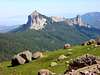
Courthouse Mountain
Chimney Rock
Stealey Mountain (Green Mountain)
West Fork Trailhead
West Fork 2-wheel and 4-wheel drive trailhead - The 2-wheel drive trailhead is located around 2.5 miles south of FR 860 and is prior to a substantial creek crossing and some fairly rough spots. The 4-wheel drive trailhead is located about 1.0 miles south of the 2-wheel drive trailhead and will shorten your day:Dunsinane Mountain

Precipice Peak
Point 13,241

Redcliff

Coxcomb Peak
[img:117406:alignleft:thumb:]
Wetterhorn Pass