
|
|
Route |
|---|---|
|
|
40.77320°N / 110.68292°W |
|
|
Hiking |
|
|
Summer |
|
|
A long day |
|
|
Class 3 |
|
|
 West side scree slope
Overview
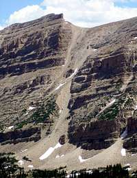 West side scree slope
This route describes a hike to two of Utah's 12000 footers, North Allsop Peak (12625) and Allsop Peak (12606), located in the High Uintas Wilderness Area. Most of the route is easy, but there is a very steep section with loose rock where you climb 1400' in .4 miles. Even experienced hikers may not like this section. This is not a hike to do with a lot of people. You are in more danger from getting hit by someone else's flying rock than anything you could do to yourself.
Stats
 West side scree slope
Start elevation: 9,100 feet
Highest elevation: 12,625 feet
Total RT elevation gain: 4,120 feet
Total mileage: 18.5 miles RT
Trail mileage: 15.6 miles RT
Off-trail mileage: 2.9 miles RT
Trail elevation gain RT: 1,640 feet
Off-trail elevation gain: 2,480 feet
Getting There
The route starts at the East Fork of the Bear River Trailhead which is located along the Mirror Lake Highway, northeast of Kamas, Utah. See the Getting There section for the Allsop Peaks page.Route Description
 Burned section of trail Burned section of trailStart hiking south along the East Fork of the Bear River Trail. The first section of trail was burned out in 2002 and is in the recovery process. You will see lots of tall skinny burned aspens rising above a lush green carpet of grass and young bushy aspens. Grazing is allowed and you will most likely encounter a few cows near the start. The trail is easy to follow. At 3.7 miles you will reach a junction where the Left Hand Fork of the East Fork of the Bear River meets up with the Right Hand Fork. Turn left to take the Left Hand Fork. These first 3.7 miles are gently rolling and you will only gain a net 160 feet. |
 Mount Beulah Mount Beulah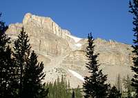 The Cathedral The CathedralShortly after the turn for the Left Hand Fork you will encounter two switchbacks as the trail climbs to bypass a waterfall. Follow the trail south about 4.1 miles from the split. In this section the trail climbs steadily but gently, and you will ascend 1120 feet. Along the way you will have views of Mount Beulah on your left and The Cathedral on your right. |
 Bottom half of scree slope up to the lip Bottom half of scree slope up to the lipAt a convenient point, in the vicinity of N40 46.238 W110 41.793, leave the trail and head cross country .4 miles, gaining 600', to the base of the scree slope which is found at N40 46.103 W110 41.435. Climb 1400' up the scree slope to the saddle between North Allsop Peak and Allsop Peak. A distinct lip is reached at about 11600'. On the way down, you need to remember to bear left at this point because if you continue straight, your path will end in a 100' cliff. |
 Large block Large blockAn interesting feature to note at 11760' is the large block sitting in the middle of the slope. It appears on the topo map as a very sudden jog to the west on the 11760 contour line just above the red route line. |
 North wall of scree slope North wall of scree slopeAs you proceed up the slope, note the rugged north wall and all the rocks waiting for the slightest excuse to fall. |
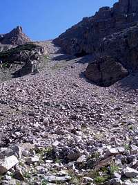
 Upper half of the scree slope Upper half of the scree slopeInitially, you will be walking along the base of a cliff to the south, but as you climb, it opens out and to the south (your right) will be a ledgy area. You may be tired of the scree by this point and be tempted to stray over that way but I wouldn't advise it because the ledges are loaded with loose rocks at head level just waiting to fall. If you are at the bottom of the couloir, at least anything you get moving will be at your feet. |
 Allsop Peak Allsop Peak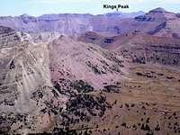 View east from Allsop Peak View east from Allsop PeakOnce you reach the saddle, it is an easy .5 mile walk gaining 226 feet along a wide, gentle ridge to Allsop Peak. From Allsop Peak you can see all the way to Kings Peak (13528), the highpoint of Utah, 16.4 miles to the east. |
 N Allsop Peak N Allsop Peak Lamotte and The Cathedral Lamotte and The CathedralGetting to North Allsop Peak is only slightly more difficult. The view from the saddle is of an imposing 50' cliff. However, it is easily skirted to the west. The summit is about .2 miles away and 245 feet up from the saddle. From N Allsop Peak you get great views of The Cathedral to the west, with Lamotte behind it. Beulah is to the north, and Tokewanna, NW Wasatch and Wasatch are to the northeast. |
Time needed
This route can be done in a long day hike. It took me 11.5 hours, but up to an hour of this time was spent on a geocaching detour. There are 6 other peaks over 12000 feet in the area begging to be climbed, North Beulah (12140), Beulah (12557), Yard (12706), North Yard (12242), The Cathedral (12224), and North Cathedral(12283), so you might want to go for a multi-day trip and set up a base camp and climb several of them on the same trip.Essential Gear
Nothing special is needed, but a GPSr is useful for finding the base of the scree slope.Map
 Route to Allsop Peaks