
|
|
Mountain/Rock |
|---|---|
|
|
35.36519°N / 117.98832°W |
|
|
Kern |
|
|
Hiking |
|
|
Spring, Fall, Winter |
|
|
2900 ft / 884 m |
|
|
Overview
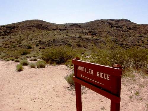
Whistler Ridge is located in Red Rock Canyon State Park, CA. It is an easy/moderate hike to the top of the ridge from Ricardo Campground making it a suitable outing for families. Those craving more adventure can hike cross-country to the surrounding ridges and volcanic buttes, and in the colorful canyons below.Spring and fall are the best times to hike in this area. In spring - March through May - this area comes alive with wildflowers - Desert Dandelions, Brittlebush, Mojave Aster, Indian Paintbrush, Indigo Bush, Paperbag Bush, Purple Mat, Mojave Owl's Clover, and many other wildflowers color the ridge and canyons below.
Winters can be quite cold and windy, and summers are very hot in this area.
Whistler Ridge was named for a museum curator, David Whistler, who has found many fossils at the park.
"One of those people is Whistler, a museum curator emeritus who is marking his 50th year searching the area for fossils. Whistler is one of the field's premiere field workers. He helped expand the number of species discovered at Red Rock to 96, up from 22 noted in a 1919 survey. Whistler's intimate knowledge of the area, Whistler's Ridge is named for him, means visitors go from desert novices to Red Rock experts in just a few short days."
From: http://www.ocregister.com/articles/julian-227347-fossil-red.html?pic=13
Getting There
Take Hwy 14 25-miles north of Mojave (120 miles north of Los Angeles via I-5 and Hwy 14). Follow the signs to Red Rock Canyon State Park - Ricardo Campground, which is about a mile west of the highway. The trail to Whistler Ridge starts near campsite 48. The trail follows a nature loop for the first 0.75 mile or so and ascends gradually up a ridge. At the top of this first ridge is a sign for Whistler Ridge. It's another 0.75 miles or so hiking up a steeper trail to the east. The trail is wide at this point and basically you're walking right on top of dark volcanic rock. At the top of the ridge a tremendous view unfolds of the surrounding colorful desert badlands landscape below. It's a great place to see erosion, uplift, and other geologic processes at work! View northeast from Whistler Ridge
Red Tape
There is a $6 day use fee or $25 camping fee. No permits are needed to hike in this area. All plant, animal, natural and cultural features are protected. Dogs on leash only in the campground - no dogs allowed on the trails. Bicycle riders must stay on all improved and primitive roads; off-roading is not allowed. Shooting and hunting, or possesion of firearms or any explosive device is not permitted. Fires are only allowed in provided metal fire rings in the campground. Please do not make rock fire rings or import metal fire rings anywhere in the park.Horses are allowed on all trails in the park, with the exception of seasonally closed areas. Horses are not allowed in the campground, however horse camping is available by arrangement at Donely Horse Camp.
All licensed vehicles (street legal and OHV with green stickers) may travel on the primitive (dirt) road system within the park. Please watch for Closed Route signs and check maps for open routes (please do not create new routes). Drinking and driving laws apply both on the paved and primitive dirt roads.
Please practice Leave no Trace ethics.
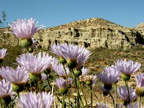 Mojave Asters and Badlands
Camping
Ricardo Campground has 50 spaces and is 1st come-1st served. Vault toilets, water spigots, picnic tables, and fire rings are the amenities. 30' max RV length, no RV hookups, dump station currently closed for repairs. Many campsites back up to the scenic cliffs which are eroded into fantastic hoodoos and caves. The nearby visitor center is closed in the winter.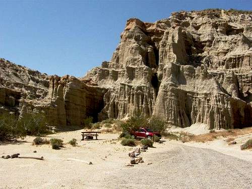 Campsite 49
External Links
Red Rock Canyon State ParkInformation from Desert USA
Information from American Southwest
Information from Digital Desert
Weather Forecast from the NWS