
-
 14205 Hits
-
 86.37% Score
-
 22 Votes
|
|
Area/Range |
|---|---|
|
|
48.27600°N / 16.33663°E |
|
|
Hiking |
|
|
Spring, Summer, Fall, Winter |
|
|
1588 ft / 484 m |
|
|
Overview
The Alps slowly come to an end in the eastern part of Austria. Conventionally, their easternmost point is described as Vienna’s “Home Mountains,” the Kahlenberg and the Leopoldsberg. Another mountain is even further east, the Bisamberg, just across the Danube from the main body of Vienna. I’ve included the Bisamberg though many Viennese probably wouldn’t.These three are by far the most prominent of the available summits, though there are dozens of named hills/mountains in this area. They rise over 300 meters (1000 feet) above the elevation of Vienna’s city center (172 meters, 564 feet). They have also played an important role in Viennese history, most notably as the base for the Christian army that relieved the Turkish siege in 1683.
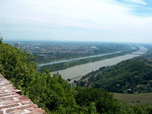 View from The Nose
These mountains are considered “home” (literally “house”) mountains because they are just within or just outside the city limits. One or more of them is visible from much of the city. They are part of a crescent-shaped range that provides the western boundaries of Vienna and the eastern boundaries of the Vienna Woods. The region has a dense, heavily used network of hiking trails, and significant opportunities for mountain biking as well.
These mountains are in no way climbing destinations, as public transportation goes to the top of both the Kahlenberg and the Leopoldsberg. The Bisamberg does not have public transportation to the top but is an easy walkup. Of course, many SP mountains have roads to the summit, even some fourteeners, so these facts should not exclude these peaks either. The question of roads to summits has raised questions elsewhere on SP.
Though they are not climbs, these mountains provide pleasant day hikes in an urban setting. I’ve put the page up so that, if business takes you to Vienna, you can get a quick “mountain” fix in the city before making more substantial plans in higher alpine regions nearby. If you fly into Vienna as part of a trip to the Alps, these would also give you something to do outdoors while you recover from jet lag. Unlike most of the mountains on SP, the downhill trip is really the more interesting direction because you walk through vineyards with ever-changing views of the city, river, and plains beyond.
The Mountains
Kahlenberg, 484 meters (1588 feet).
This mountain was originally called the “Sauberg” (Sow Mountain) but received its current name in 1679 when that name found itself without a mountain (see below). It has a restaurant on top, the Stefaniewarte, as well as a radio tower. The chapel on the top of the mountain was rebuilt in 1734 after being destroyed by the Turks. It is a popular quasi-pilgrimage destination for Polish tourists because of the role of King Jan Sobieski in relieving the siege of Vienna. Pope John Paul II visited the church and there are plaques and prayer benches honoring his visit.
Leopoldsberg, 425 meters (1394 feet).
 View of Leopoldsberg from Bisamberg Ascent
Bisamberg, 359 meters (1178 feet).
The Bisamberg (Bisam “Mountain”) is certainly a noticeable hill but it is much smaller than the mountains on the other side of the Danube. I’ve been told by knowledgeable Viennese friends that this is the “last hill of the Alps,” and the only Alp on the eastern side of the Danube. I’ve also been told that this is the “first hill of the Carpathians,” an honor that residents of Bratislava (Slovakia) claim for the hill at Devín. Other Viennese have claimed the Laaer Berg or the Leopoldsberg as the “last hill” of the Alps. I say, “climb them all!”
The local commune (Gemeinde) has its own website in German only. Most of the information there is not useful for non-residents, but you could check the calendar for special events while you’re in the neighborhood. The commune as a whole is about one-fourth forest, with a significant amount of other open spaces (farm, pasture, and some fallow).
 A Knight Guards the Route
Getting There
These instructions are for people using public transportation; if you’re driving a private car, shame on you. For this northern part of the range, the Heiligenstadt U-Bahn station serves as your base station. This station serves as the end of the green subway line. Coming from Vienna, exit the station to the left to find the relevant bus lines.If you just want to go to the top of Leopoldsberg or Kahlenberg, take the 38A bus line. This lies within the Vienna public transportation system, so your daily or weekly pass will be valid. It goes through the Heiligenstadt district, a pleasant residential area, and then through the tourist district of Grinzing. Check the schedules on the sign at Heiligenstadt, as the bus sometimes stops in Grinzing, sometimes stops at Kahlenberg, and sometimes goes all the way to Leopoldsberg. If you goof, just get off the bus and wait, there will be another one going farther within a half hour.
The bus route goes up the Höhenstraße (High Street), which was not built until 1935. Before then, a cog railway took visitors to the top of the Kahlenberg from 1874 until 1914. The railway has been dismantled, but if you take the Nussdorf “descent” described below, you’ll see some leftover tracks near the streetcar station at the bottom.
Routes: Leopoldsberg and Kahlenberg
 Typical View from Trails
The Leopoldsberg-Kahlenberg Traverse
Get off the 239 bus from Heiligenstadt at Kahlenbergerdorf. You exit the city limits and will need to pay additional fare (about a euro). If you see a little village with masonry steps going up the hill to the right, you’re at the right place. The path up the mountain is paved, mostly with paving stones, and has decorative steps, obelisks, viewing platforms and other silliness all the way up. The path was developed in 1877, but the route was used long before - - Beethoven was a fierce walker and used it regularly.
You’ll emerge from the path to see a restaurant at the top. It has very nice views and very poor service (in my experience), so order drinks instead of a meal. When you’re done enjoying the view, exit the parking lot and use a path just below the road on the left side. This will take you across the saddle between the Leopoldsberg and Kahlensberg. On the saddle you’ll find a small restaurant (Josefinenhütte), which I haven’t sampled, a children’s playground, and a grass suitable for picknicking.
There’s a road junction there, and you want to continue up the path that goes uphill parallel to the road that forks up to the left. After 10-15 minutes, you’ll reach the Kahlenberg, which has great views of Vienna. The restaurant gets a lot of tourists, and there are two gift shops as well as a snack stand for ice cream and/or a beer if you prefer. There’s a nice little church of St. Joseph on the summit, which attracts Polish visitors as a quasi-pilgrimage site. Pope John Paul II visited and is remembered at several places in the church.
Descents
Tourist descent to Nussdorf
The main tourist descent goes down to the Nussdorf district of Vienna. I’d recommend timing this trip so that you finish around dinner time. This descent is the most common tourist route, and you won’t be alone. From 1874 to 1914 there was a cog railway that went up the Kahlenberg roughly along this descent. Just take the Kahlenbergerstraße, which drops off to the right of the restaurant/gift shop on the summit.
Alternative descent: Klosterneuburg
From either the Kahlenberg or Leopoldsberg you can descend on the back side, toward the monastery town of Klosterneuburg, an upscale suburb of Vienna. There’s a major trail (logging road, really) that traverses the slope across the backside of these two peaks, and it’s easy to find from either location if you just pick a trail and walk away from Vienna. From there you can find several different trails down into the village, each of which ends in a steep street.
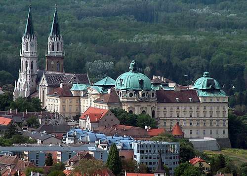 Klosterneuburg
Your goal is simple: march in the direction of the giant monastery, which remains in view no matter which route you take. Many routes funnel into the Sachsengasse, which becomes the Agnesstraße when it crosses the busy Weidlingerstraße. This is a good route because it goes directly to the monastery. If you end up descending by something else, you’re probably a bit closer the Danube than is ideal, so when you hit the Weidlingerstraße, bear left until you hit Agnesstraße. If your busy street is called the Brandmayerstraße, bear right instead.
Either way, once you’re on the Agnesstraße, keep going straight ahead to the famous monastery. of Klosterneuburg. After touring the monastery, and perhaps enjoying the wine from the monastery’s cellar, go down the back side of the hill (viewed from Vienna) and the road will take you to a train station. There’s a local train that comes by regularly that will take you back to Vienna for about a euro.
Alternative route: the City Walk
If you read German, you can find a description of the City Walk 1a, with pictures, here. It starts and ends in the Nussdorf district and includes a little front and back material that I’ve excluded. It also saves you the bus fare outside the city limit.
Routes: Ascending the Bisamberg
Introduction
The route is based on an official Vienna City Walk. The webpage with that information is in German, and is not very detailed. This report has much more detailed directions, and of course it’s in English.
Overview
 Sunken Road
The path also unveils interesting views of Vienna and its house mountains from a different perspective. At the top of the mountain the path changes character again, returning first through the woods and then breaking into open fields before returning to vineyards.
The city has installed about a dozen interpretive signs, all in German. A brochure listing these stations, and showing others in the area off our path, is available partway into the walk. Some of the stations provide interpretation for part of the hill’s history. Because it is the only high ground on this side of the Danube, it has long had military importance. I’ll provide some other interpretive information as we go along.
Getting There
It’s a little tricky to get here, compared to the other Wiener Hausgebirge routes. You want to take the streetcar #31 (Straßenbahn 31). You can catch that line from its start in the first district (Schottenring station) or use the subway (U-Bahn, line U6) or fast train (S-Bahn, various choices) to Florisdorf.
 Leopoldsberg in front left, Kahlenberg behind right with TV tower
The Route
Directly ahead is a sign with a map of the area, including the walk up the Bisamberg. Another sign lists the local vintners that are currently offering new wine (Heuriger). From the station, go left down the Josef-Flandorferstraße. This takes you through an uninteresting modern part of Stammersdorf.
After ten or fifteen minutes, you’ll turn right on Luckenschwemmgasse. After about two blocks, cross a small square and take the path that clearly leads up to the church visible in front of you. (This path is the Liebleitnergasse.) This church of St. Nikolaus was built in the 12th century.
The only way around the church curves to the right and then guides you back to the left. Notice the walled areas around the church, including some built directly into the church. As you might surmise, this church and its was often used for defence in time of war. Stammersdorf has been pillaged or burned by a long line of invaders including Magyars, Mongols, and Turks. The village played a minor role in the battle of Wagram, as the Archduke Charles posted cavalry on the Bisamberg to keep an eye on French movements on the plain below. Because of its aeronautical factories, it was also bombed by the allies in World War II.
After the village church, the walk changes character dramatically. Above the church, follow a street to the left (Clessgasse) that goes along the wall. You will soon see a narrow road head up to your right, the Neusatzgasse. It soon becomes clear that this is a sunken road into which the local vintners have cut wine cellars; the vineyards are on top of the road and often out of sight. As you continue to climb gradually, you’ll see vineyards laid on top of gentle slopes or cut into cliffs. The Bisamberg benefits from rich loess soil, and most of the grapes are local varieties (Grüner Veltliner, Zweigelt) that are rare outside Austria.
The Neusatzgasse gradually curves to the left and then crosses a major street (the Stammerdorfer Keller). If you’re here in the afternoon, you can obtain refreshments at the restaurant, or head on. The trail continues at the north end of the parking lot, where you will see another map of the area. Go left on the Senderstraße. This is a small street, with occasional Heurigen, that continues uphill.
Before you reach the top, a sign will point you to the left up a dirt track. It’s possible to take a shortcut by staying on the Senderstraße, but I strongly recommend that you follow the path left for the best views of the city on this walk.
The track takes you around a field on the edge of a hill. At times you’ll be walking above a cliff and can see vineyards and field directly below you. This stretch of trail is shaped like a V and you’ll soon turn to the right and go up toward the radio and TV towers. The northern tower is 265 meters high, the highest construction in Austria.
On the other side of the towers is the Magdalenenhof, which is the kind of place one might hold a wedding reception. It belongs to the city of Vienna. The name comes either from the former Magdalene convent or from the wife of a former farmer, Magdalena Müller. Maybe the name comes from both.
Curve around the Magdalenenhof to the left and then continue right around it up the Oberer Klausgraben.After a short distance you’ll see a monument to a poet with a nice poem on it.
If you want to get as close to the summit as possible, turn left and continue up through woods for about fifteen minutes to a parking area. (At this point, we have diverged from the official City Walk.) There’s a fenced-off radio tower on the summit (Elisabethhöhe), and just get as close as satisfied your summiting urge. That done, go back to the statue with the poem.
The descent, such as it is
If you didn’t summit, turn right; turn left if you’re returning from the summit. You’re in the edge of some woods, with children’s playgrounds clearly visible just through the trees. This promenade starts to take you back downhill on the Bisamberg ridgeline. The promenade curves sharply downhill to the right. Recross the busy Stammerdorfer Keller into the Mitterhaidenweg (the Middle Heath Path). The woods on your right are the Herrenholz, or Lord’s Woods. This was a favorite hunting site for Franz I, consort of Empress Maria Theresia. In 1805, the Archduke Charles and Napoleon held an “imperial rendezvous” here during their war of that year.
Come down the Mitterhardenweg to Luckenholzgasse, which you’ll take as it curves to the right. There are old fortifications on left, built to protect aircraft engine facotry in the WWII. Cross In den Gabrissen and walk through the edge of town to the Clessgasse, where you will turn left.
The Stadtwanderweg route markings guide you to the right on a slightly larger street, the Erbpostgasse, but you stay on this road only very briefly. Turn left into the larger street in front of you is marked the Freiheitplatz (Freedom Square) and soon becomes the Stammerdorferstraße. After a few blocks there is a small street on your right, Herrenholzgasse (Lord’s Woods Alley), which will take you right back to the streetcar station.
Red Tape
 Gates of Hell
There's no red tape, but you’ll probably end up paying for public transportation. Viennese public transport does not check your ticket when you get on the system, but relies on an honor system. The honor system is enforced with spot checks, and if you’re caught without a ticket the fine was 50 euros the last time I was there. The bargain method for a tourist is to buy a weekly pass for 12.50 euros; a three-day pass costs 12 euros, so it’s hardly worth the savings.
Other Activities
Mountain biking
The roads and (where permitted) trails are popular mountain biking destinations. Bike rental is abundant in Vienna, and bikes are permitted on public transportation. Taking the bike on the 38A bus to Kahlenberg will likely annoy your fellow passengers, however, because it’s usually pretty crowded on board. Helmets are not common in Austria, so if you’re a North American who feels naked without a bike helmet, I’d pack it along.
Trail running
The dense network of trails here lend themselves to running. For a straightforward run of any length you want, start at either mountain and then run the ridgeline counterclockwise. Trails will drop to either side of the ridge but stay tolerably close to the top. When you want to finish your run, pick a trail that drops off the side to your left. If you continue downhill, you’ll hit one of the streets that shoot out from the city center like spokes on a wheel. These all have busses, and a few have streetcars.
Eating and drinking
In the US, climbs and hikes end with a beer. Here it should end with a “G’spritzter,” wine mixed with seltzer water, served at a “Heurigen” (wine garden). As you come out of the hills, you will come across a large number of these wine gardens. They date to an edict of the Emperor Joseph in the 18th century that allowed vintners to serve their own wine without paying tax. To enjoy this tradition, look for establishments with an outdoor garden in back adjacent to its own vineyards. You’ll normally sit on picnic tables and eat from a buffet that includes various stereotyped items such as fried chicken, sausage, and potato salads. You can stay for hours, but you will need a reservation on weekends.
Both the wine and the localities that sell it are called Heurigen; if you speak German but not Austrian German, be aware that this noun behaves like an adjective, originally from der heurige (Wein). One would say der Heurige schmeckt (the wine tastes good) but ich trinke guten Heurigen (I’m drinking good wine) and “at the Heurigen” is “beim Heurigen.” Be sure to practice German grammar with the wine in front of you.
When the family has new wine, they will hang a pine bough over their door. This is called being “ausg’steckt” (having “stuck out” one’s pine bough) and one can say that the place “is ausg’steckt.” Ask for both wine and soda water (Sodawasser) by the liter, and mix according to taste and desired sobriety levels. Enjoyment is mandatory, as Vienna is the only world city with commercial vineyards inside its city limits.