
|
|
Route |
|---|---|
|
|
43.92730°N / 114.0845°W |
|
|
Trail |
|
|
Half a day |
|
|
Walk-up |
|
|
Approach
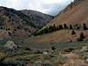
Wildcat Canyon is accessible from the junction of Trail Creek Road and Wildhorse Creek Road. Coming from either the east of the west, turn onto the road to Wildhorse Canyon (there is an information kiosk across from the junction.) After about one mile follow the signs to Copper Basin (FR-135). After crossing a one-lane bridge, turn left just before a fence. Turn left onto a rough two-track road and park at a faint turnaround area. If you pass a sign that says "river access," you have gone too far.
 |
Route Description
This route is very easy and straight forward. Just follow the trail to the top.
Drop down onto the banks of the East Fork of the Big Lost River. After crossing an ATV/pack/footbridge, follow the trail up into the canyon. This trail is maintained by the forest service and is easy to follow. From the trailhead to the lookout on the summit is about 3 miles one way and 2,500 feet of elevation gain. There are a few shady spots on the trail, but most of the trail passes through subalpine meadows.
This peak and route are fairly popular and you may see an ATV group on the trail during a summer weekend. When we went up during a 4th of July weekend, we were only accompanied by two dirt-bike parties, but only briefly. Not too crowded considering the holiday. Off trail ATV use is prohibited, so the area is as pristine as other areas with maintained trails. From my personal experience, you will find more people and a much wider trail at Cascade Canyon in the Tetons, for example, than you will here, ATVs or not.
 |  |  |
Essential Gear
Day hiking gear and water.