
|
|
Route |
|---|---|
|
|
46.35493°N / 7.85625°E |
|
|
Trad Climbing |
|
|
Summer |
|
|
Most of a day |
|
|
max III+ UIAA |
|
|
Overview
Wiwannihorn - Trittji (Normal Route)
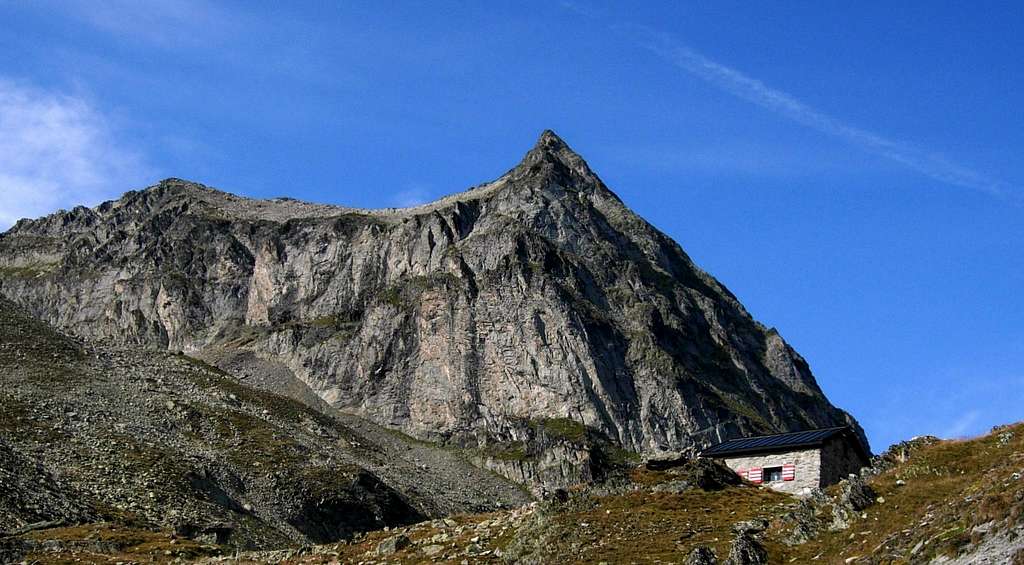
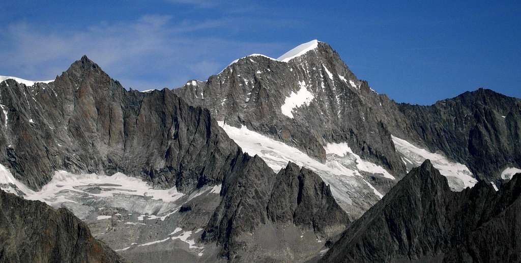
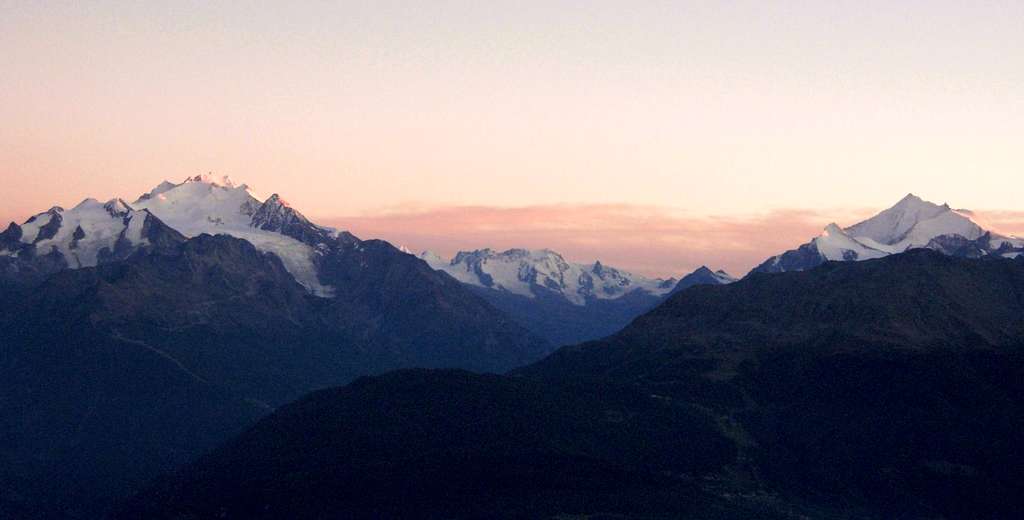
Wiwannihorn 3001 m is a magnificent mountain exceeding the threshold of 3000 meters - even if only for one meter! - belonging to the Bernese Alps and located above the Rhone Valley, in the Wallis canton, to the North of the village of Ausserberg. In detail this granite mountain lies on a chain between the Bietschtal and the Baltschiedertal, South of Bietschhorn, an impressive peak also called "the Matterhorn of the Bernese Alps". As well as being a particularly scenic top by virtue of its location right in front of Bietschhorn and the Mischabel range, Wiwannihorn is quite popular in reason of its several technical and well equipped multi-pitch routes leading to the top, amongst which the most famous one is probably the Steinadlerroute.
Moreover the summit can be climbed via a route that opposes quite moderate difficulty, the interesting Trittji, the standard route. A great outing, especially if combined with the descent along the West ridge.

|

|
Getting There
The reference location is the village of Ausserberg 1008 m located in Baltschieder, a valley starting near Visp (Rhone Valley), opposite to the Visper valley that leads to Zermatt and Saas Fee. You can take the train to Ausserberg either from Berne (North) or Brig (South). If you have your own car drive along the E62 through the Rhone Valley getting to Visp. Take the direction Baltschieder, pass the trainstation, then cross the Rhone river and drive to the village of Baltschieder and Ausserberg. From Ausserberg the ascent is about 4 hours. Alternatively a toll road continues up to Fuxtritt parking lot located at about 1850 m of altitude. You can buy a passage authorisation in one of the restaurants or at the car-park on the top of the village Ausserberg. This fee also contains the parking fee at Fuxtritt. From this latter the approach to the Wiwanni shelter is much shorter than starting from Ausserberg. You can also get the taxibus to Fuxtritt.

|

|

|
Approach to the hut
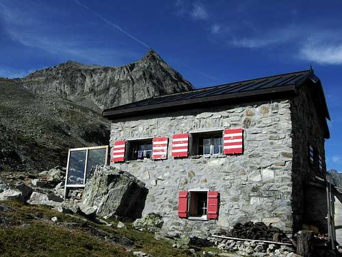
From the parking at 1850 m an excellent trail through a beautiful larch forest leads to the nice Wiwannihütte 2470 m in about 1h30. You can spend the night, but check the availability, because the shelter is often full.
Route Description
Wiwannihorn South Face Normal route aka Trittji
Difficulty: max III+ UIAA
Equipment: the route is equipped with bolts and marked by blue signs
Length: 200 m.
Exposure: S
A fun and easy climb on solid granite through the South face of Wiwannihorn
From the Wiwannihütte follow the wide track (cairns) that moves left in the direction of the two Öugstchummuhörner, Grossman and Chlys, leading to the basin at the foot of Wiwannihorn South face. The starting point of the standard route is located just below the summit, to the right of the water trough firn falling from the summit slopes, above a characteristic boulder made of white quartz.

|

|
Climb up a series of slabs, ledges and steps leading up to the summit scree, frequently in snow. Overcome the easy summit scree and reach the summit, supporting a cross dated 1957. The view to Bietschhorn, "the Matterhorn of the Bernese Alps", is breathtaking! Route marked in blue with old spits maximum III +, solid rock and pleasant climb.
Click here for the route topo Trittji route topo

|

|

|
Descent - from the top head westward along the obvious ridge. The first difficulties are bypassed to the right, the next ones to the left. The orientation along the route is helped by some blue marks and the climb by some natural anchors and spikes. The ridge leads to a saddle between Wiwannihorn and Augstkummerhorn where is located the first abseil anchor. Two abseils will lead you on the stony field (snowfield at the start of the season) at the foot of the wall.
Essential Gear
Normal climbing equipment (2 ropes 50 meters, helmet, slings, quickdraws)
Red Tape
No permits required. It is important to pay attention to the road rising from Ausserberg to to Fuxtritt; it's a toll road. Buy the ticket in Ausserberg.
Hut
Wiwannihütte
Wiwannihut is situated at 2470 meters above sea level and offers 28 sleeping places. The hut has two dormitories, one with 20 beds and another with 10. It is a good departure point to hike and climb choosing from different possibility of sport and alpine routes on the excellent rock.Usually the hut is staffed from the beginning of June to the middle of October. The hut is often used for school camps.
When to climb
Best months to climb are July, August and September
Bibliography

Kletterführer Wiwanni - Egon Feller, Edition Filidor, 2010
Maps: 1/25000 - Raron 1288 - Lötschental 1268