Prep, bus, facts.
A long time ago, when I was not as much thoughtful as I am nowadays, I accepted a invitation to hike Ciririca Peak from a former friend without any second thoughts at all. Ciririca happens to be one of the most challenging hikes in southern brazilian region. Some say one of the hardest in our country, but I wouldn’t say that much. It is normal to find people that speak about Ciririca as "
The brazilian K2" (too much I d say). In fact I do know dozens of people who tried Ciririca for years to reach its summit, and when they do it, the trip report usually starts with “
The conquest of Ciririca (...)”. I should think about all those things before the adventure itself.
I heard this former friend say to me “
Let’s go to Ciririca, but I must tell you, it is not easy, the first time I did it (and the only one I might add) took me two days and under dangerously strong rain, let’s do it?”. As I said, no second thoughts at all. “
Man what are we waiting for?” was my answer.
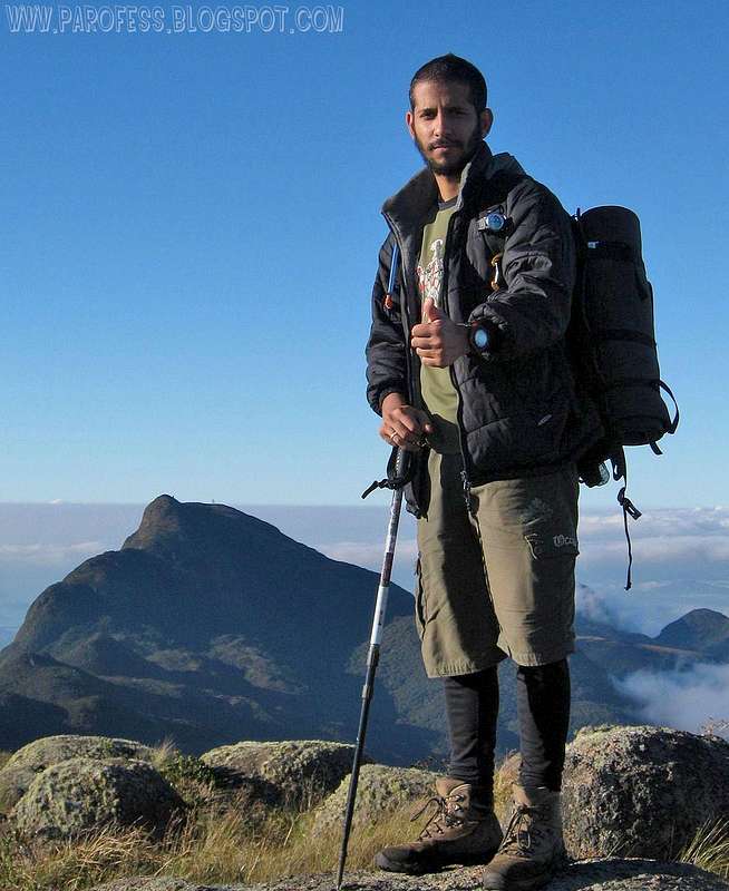
I got the bus ticket, got my backpack prepped with food for 4 meals, and a few snacks, that’s all. Went to the main bus terminal of São Paulo (Tiete) and got the bus ticket to Curitibia, Paraná. Land of the gorgeous mountains of Ibitiraquire Sierra, mountains I love and that have a particular spell over southern brazilian mountaineers, some of them spend their entire life inside Paraná, and they think they never have to leave home searching for mountains since they have so much just 30 miles away from their beds. Well I never agreed with that, but I am different, my country is so big that the highest peak, Neblina Peak, is 3000kms away, and just a few summited. Where was I? Oh yes, the bus ticket...
After that, came back home and said to Lilianne I had to go away for the weekend for this tough mountain in Paraná. That was in the middle of the week, and by Friday I was on the bus going for it.
There is plenty of options to reach Ciririca Peak, but, of course, we pick the toughest there is, the “up trail”. There is a “down trail” that goes only for the peak but then it would be just too easy, and nobody does it using this route only as the way back. In either cases, just to reach the farm is a big trouble if you don’t have a car, just like me. We had to get off the bus on the road, 45 kms before Curitiba, at 4am just to start walking.
Altitude gain/ loss?
The way from the road to the farm where the trail begins is around 6kms. We reached the farm around 06:15h and we had the whole day ahead of us. But the way....ah, not so great, check this out:
First of all – 6kms walk from the road to Bolinha farm (950m high). OK
Second – 7kms to the summit of Camapuan Peak at 1706m high.
Thrird – Another 1km hike to the summit of Tucum Peak at 1736m high.
Fourth – Another 2kms hike to the summit of Cerro Verde at 1653m high.
Fifth – Another 2kms hike to the summit of Luar Peak at 1635m high.
Only then, the sixth, last, and hardest job – Another 5kms hike to Ciririca Peak summit, and this one includes descend from 1635m to 1000m and only then start the final ascent at the main ridge of the mountain.
Boy I gotta say, this is not easy!!!
Do the math, it is a total of 23 kms just to reach its summit!!! That is the reason so much people give up at the second or third day, most people camp atop Cerro Verde or Luar Peak and only the next day try the summit, but the weather changes very, very fast on Ibitiraquire Sierra, and believe me, you don’t wanna get caught in that, it is a wet hell.
The altitude gain, well, let’s make a fast math:
Altitude of Bolinha farm: 950m
To reach Camapuan summit: + 756m
To descend Camapuan and to summit Tucum: - 70m/ + 120m
To descend Tucum and to summit Cerro Verde: - 325m/ + 230m
To descend Cerro Verde and to summit Luar Peak: - 230m/ + 205m
To descend Luar Peak and to summit Ciririca Peak: - 635m/ + 720m
That means the numbers:
Total of vertical descent: 1.260 m (- 4.134 ft)
Total of vertical ascent: 2.031m (+ 6.631 ft)
Man, can you guys believe that? That means the altitude gain we had to do to reach a 1.720m peak is 300 meters higher than the peak itself!!! XXXX yeah! Now I think you guys will get the point of me saying again and again Ciririca Peak is a tough little mountain, don’t you? That’s why people do it in two days, some three days.
Step by step
![Camapuan Peak summit]() Camapuan summit, first of five summits for that day.
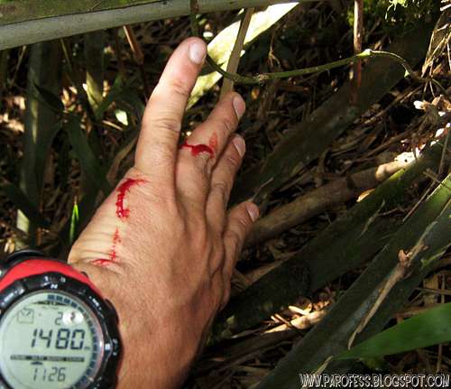
Camapuan summit, first of five summits for that day.![Cut on my hand. That hurt!]() The cut, man the hurt big time...
The cut, man the hurt big time...
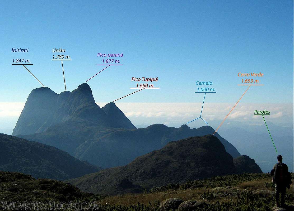
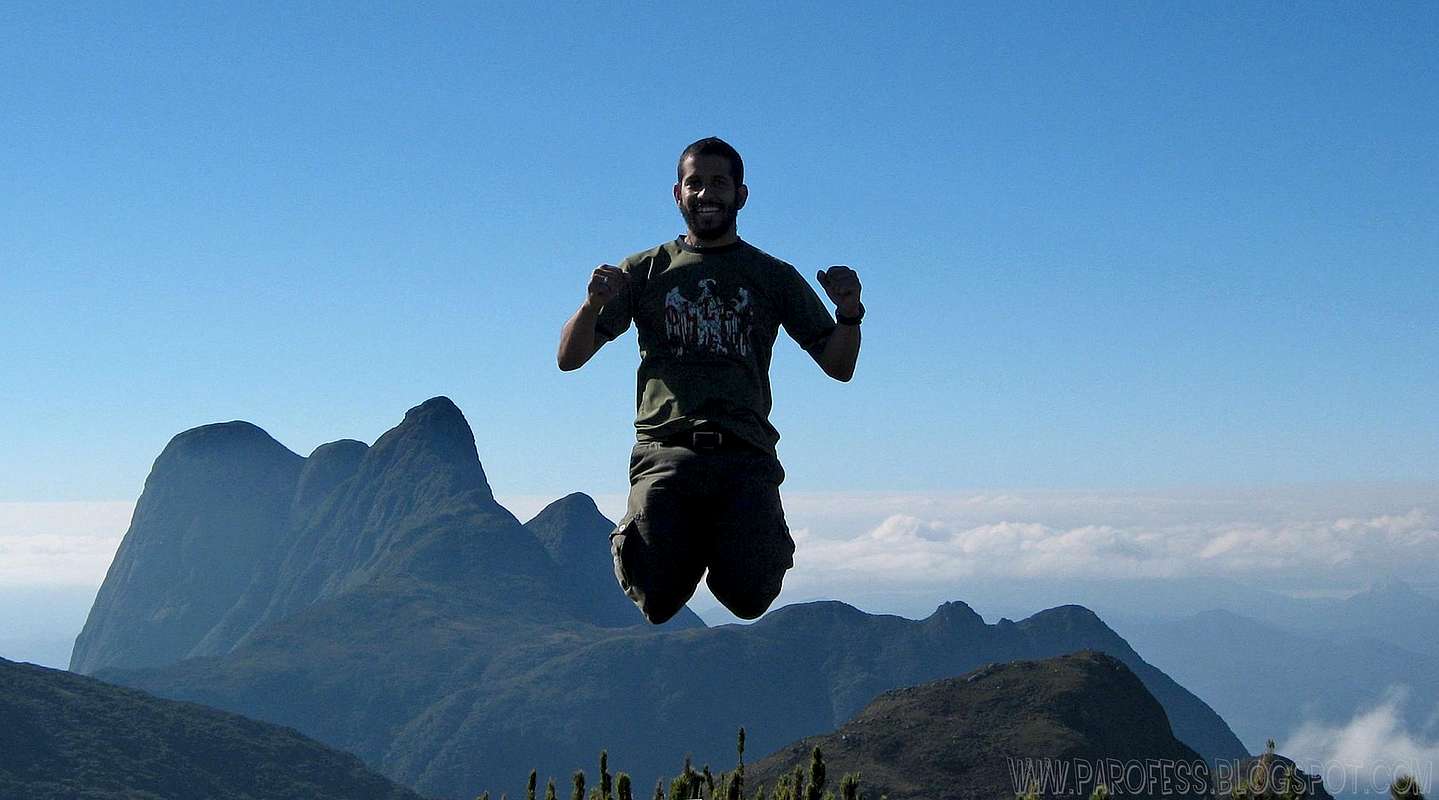
The mission was on GO and after an hour and a half we reached Camapuan Peak, stunning photos, incredible view, and the weather was just PERFECT, very rare situation on Ibitiraquire Sierra. I did the best shots I have of this Sierra on that moment. We didn’t had much time to waste so after dozens of shots we went to Tucum Peak, which he reached just 25 minutes later. Still energy full, as happy as we could be, enjoying the views and the photos, Paraná Peak group is just fantastic from Tucum Peak summit, like a piece of art, a big ass one! It rises 900m from the valley bellow as a massive ammount of hairy rocks pointing to the sky...
The most dangerous part of the hike is this one, Tucum descent. From that point on, THERE IS NO TRAIL since the rain never stops on Ibitiraquire range and the woods grow fast hiding every possible path. Some years ago hikers from the state (very good ones) marked the path with little peaces of red plastic, and we had to follow them no matter what. But, the descend route itself was a challenge, very, very step woods, all the time between 50 and 60 degrees, we call it “
root climbing” hehehe. For a small section, it turns out to be around 70 degrees, man that is actual climbing!!! Grabbing on roots of course. There is an old rope some 8ft long at this section, but it is not to be trusted. At the bottom I had to jump to reach the soil and I hurt my hand, that wound kept bleeding for hours and the scar still on my hand.
Once at the bottom of the valley, the terrain transform itself into a scary movie situation, the green leeves on the ground grow over the tree roots, but the tree roots are exposed, and it is kinda like a green blanket over roots. Not just that, it is thick so it is strong enough to hold a human above it! It is a wierd feeling, much like walking over my bed, that is the closest definition I can give you guys, if you jump, the whole ground moves!
It is not to be trusted too, the secret is to look for the roots and use them to walk, but if you hit some blind spot, you can end on the bottom of a hole and die, it happened before. At this point is very easy to get lost since you have to pay attention to the plastic things on the trees, and you have to keep looking at the soil looking for places to step on! Man, what a crazy spot to be...
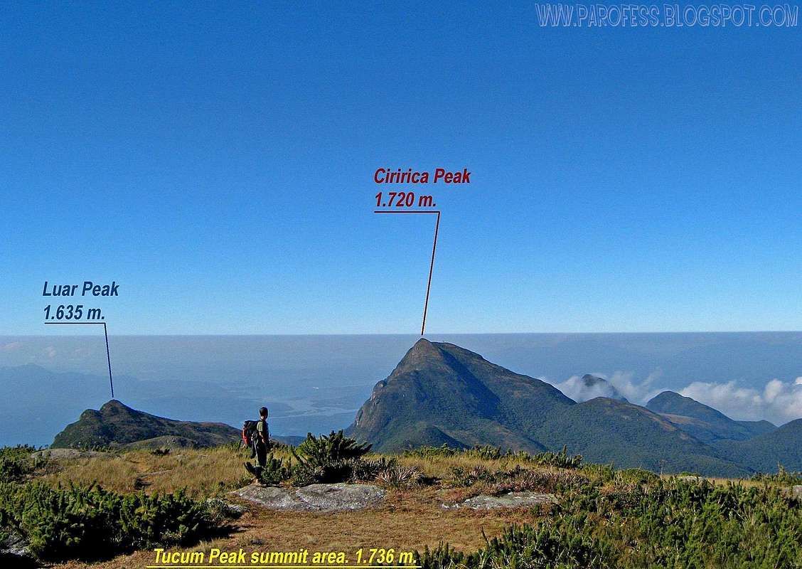
It took us like two hours to cross this awful place to good soil again, with low grass...We where at 1.400m high now and looking at Cerro Verde Peak, so we stoped for a snack. Some 15 minutes later we left the big backpacks at this point and did a fast run to its top at 1.653m. That took us around 45 or 50 minutes. Photos and more photos, we got back to the point and the time wasn’t so good, noon already. We had lunch and half an hour later, walking now slowly we where on our way to Luar Peak.
We got there almost 2pm. Not much time at its summit and we went down since the worst part was now. Man, what a xxxxhole! No trails, no trails at all, sharp plant cutting our skin like butter, and a couple hours later we reached a river, and I was feeling a “ponty” pain at my right leg, almost at the top of my thigh.
Pain, summit, home.
![]()
Parana Peak group from Tucum summit.
![]()
Another great informational view.
![]()
Jump over the summit box of Tucum.
I said to him “
Dude, we have to slow down for a bit, I have a crazy pain on my leg and that is slowing me a little bit...”. He waited for me, and I went over a dead oak tree and all of a sudden the pain turned into a excruciating pain which made me literally cry. I yelled at him for help, to get me on my feet again, he came and helped me. The situation now was pretty much different, the extreme hiking experience became a matter of life or death on that river.
It was winter, and the temperature for now was around 30°C, but at nightfall could get to –5°C, and by that river the chill d made that even worse. Now I didn’t want to reach Ciririca Peak summit, I had to. At baby steps I got up and started walking again, very much in pain, me and my 13kg backpack. The trail was the river, almost dry because of the season (not dry because of the persistant rains of Paraná even in winter time), and it was easy, just as easy as go to the corner of my street, but I was just too damn slow.
This part could be done in like 20 minutes, but it took me like a couple hours just to reach “
last chance” point, it is a point of no return, if you are willing to go for the summit, just go already, if you feel like you don’t have a chance, give up and turn back home. The name is really this: “
Última chance” (portuguese for “
last chance”). It means “Last chance to go home”. Kinda of a warning.
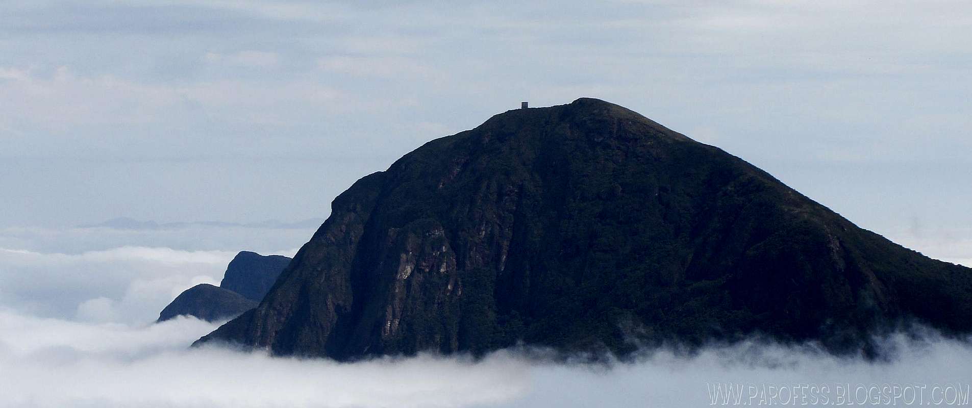
![]()
Ciririca Peak from Luar summit.
My former partner was not very patient with me, and worse, he did this hike just 10 days before and he couldn’t remember the last chance stop. What a xxxxxx memory...So I was in pain, for the first time on the most dangerous and tough trail of Paraná state, with a partner that did this very trail ten days ago (yey!) but he couldn’t remember jackxxxx about the “
last chance” point (:/ ). Get the picture?
Obviously I got mad, and I questioned him some times about the way up and all I could hear was “
Man I can’t remember!”. My thoughts by this time were “
Why the xxxx did you envited me anyway you stupid?”, but I never said it outloud.
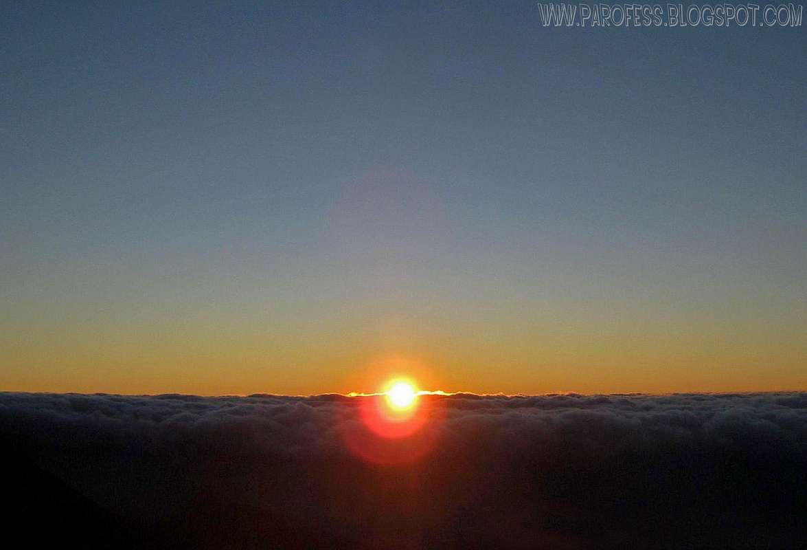
The sun was going down, it was around 5:45pm, it was a lot colder now, my pain was very much the same, and he was concerned about the sunset. WFT??? Even more, he got mad at me for ask for his help to hike to last chance, which he found at the very last minute before the sun goes down.
The “
last chance” is a short hike up by the river with no marks at all, slightly visible, that goes up some 70 feet and get you at last just abovethe tree line, at the final ridge to Ciririca Peak. He did it in one minute I guess, but it took me like five or seven minutes to reach him, already with the tripod and camera at hand, shooting the sunset. Why is that more important then your friend in pain??? He had several, hundreds of photos of dozens of sunsets around Brazil, why this one was so important? I never understood that.
Finally at the ridge we started the final ascent to the summit, and sometimes the pain was so strong I almost collapsed, but I never said a word about it since he was pissed off already. We reached the top of the ridge by night, around 7:45pm, and when he saw the huge metal plates on the summit he looked at me and said: “There is the summit, happy now?”. And that was pretty much all the talk for the night. It took us 14 hours from the road to the summit of Ciririca Peak.
![Me by the thing]() Summit.
Summit.
At the summit we bumped into three friends, they already did the up trail and went up by the down trail to try Agudo de Cotia next morning (a mountain after Ciririca). As we saw them at the farm, they were worried about us and the delay of course, by that time, they though we gave up hours and hours before that, but we didn’t.
At the summit, I crashed at the ground and I only moved when the blood got cold at the 2°C weather. Got my tent ready, dinner, and sleep.
![A new day comes...]() New day comes...
New day comes...
Next morning I was a mess, the pain was smaller, but just in some positions. Early in the morning we did the summit shots bellow the plates, and he said to me he was going for Agudo de Cotia, of course I couldn’t go, I had to go home alive first, and that leg was gonna give me a lot of trouble I guessed. Luckly, Barbara, one of our friends, had some powerful painkillers with her, she gave me one and man, what a life saver...
As the dude was taking too much time to get back, we decided to head down to the farm and when we got all backpacks ready, he came by at the last minute. The painkiller was a great deal of help since it took away like 80% of the pain! So I was walking good again...
It took us around 5 hours from Ciririca summit to the farm again, after around 8kms of well marked trail, the down trail.
After a few hours we were on the bus going home, and things got a little better. The ride takes around 7 hours so we had much time to talk about what happened, things that had been said and a few apologies later we were okay, but not really OK. This trip was back in june 18, 2009. I never forgot the details of this, for me, so far, the hardest brazilian mountain I ever summited. It took me like one month to get better on the hurt leg, and other five months or so to feel completly recovered. I never saw a doctor.
Cheers folks
Parofes


Comments
Post a Comment