
-
 866 Hits
-
 75.81% Score
-
 6 Votes
|
|
Route |
|---|---|
|
|
19.21579°N / 99.90987°W |
|
|
Download GPX » View Route on Map |
|
|
Hiking |
|
|
Fall |
|
|
One to two days |
|
|
Class 3 |
|
|
Overview
If the ascent to Xinantécatl has not been enough for you, and you are looking for a greater adventure, whether it be for the attraction of risk, aesthetic appreciation or for scientific purposes, you can read the following lines. The volcanic activity of the Nevado de Toluca and the mountain range next to it have built gigantic earth and rock bridges from its cold and inhospitable surroundings, which may, through ridges and volcanoes, unite these icy wastelands with the tropical portions of the south and west. from Mexico. The Sierra San Antonio is that bridge, which joins the 4686 masl of Xinantécatl with the lowlands (below 2000 masl) of Valle de Bravo and the balsas depression, covered with tropical forest and wrapped in a warm temperate climate, attractive for a long time. decades for international tourism looking for exotic foods, extreme sports such as paragliding, motorcycling, MTB cycling, climbing, etc. It is the wonder of Mexico, being able to enjoy enormous altitudinal gradients with all its ecosystems immersed, in a very short time. In the next text, a couple of routes are described, made up of numerous paths, trails and gaps that cross the San Antonio volcanic complex, from the fourth highest mountain in Mexico and all of Central America to the tropical and tourist paradise of Valle de Bravo in a trajectory that oscillates around 40 km. Regarding the unevenness, approximately 30 km are totally downhill (from 3,400 or 3,600 masl to 2,300 or 2,000 masl), and the remaining 10 km are intended to reach the highest points of the mountain range, which serve as mountain passes; These divide the great highlands and valleys of central Mexico from the east, much more rugged and immersed in complex volcanic fields, as well as from the south of the country, in a geographical depression of lands with a hot climate. The trip described is offered by many tourist agencies, guides, and pseudo-guides at high prices, in the order of $5,000 Mexican pesos per person, roughly equivalent to $280 US dollars, due to the sublime wooded landscapes, the presence of the monarch butterfly in winter or the “Corral de Piedra” ecotourism park nestled next to a large boreal-looking dam. In the writer's opinion, it is better to provide the instructions, recommendations and important knowledge to the general public, so that they can undertake the expedition on their own, paying for the trip with nothing more than their own physical and mental effort, rewarding in a more close to authentic nature and exploration. I have traveled both routes, spending less than $200 Mexican pesos, or less than $10 dollars.
After all, the possible risks are reduced to getting lost and spending a very cold night, although with the assistance of a GPS, cell phone maps and the necessary clothing it is difficult to suffer problems. At the end of the tour, without a guide, you will have crossed 3 or 4 totally different ecosystems, overcome a drop of more than 1500 m, enjoyed a wonderful climate, and the transition, culturally, from one region to another. It is possible to camp or rent a cabin in the middle of the trail (for approximately $1,000 Mexican pesos or $56 US dollars), being able to cover the itinerary of 1 to 2 days. It is also possible to rent local guides in local towns, which will be a more realistic price.
Getting There
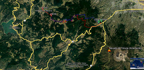
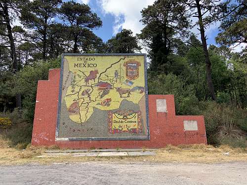
You can reach two different starting points, depending on which of the two routes you will take. In advance, I add the possibility of starting this route in Valle de Bravo, which can be reached by bus from Toluca or the West Terminal of CDMX, being able to request a taxi from Valle de Bravo to the Great Stupa. In any case, for the viability of the journey, it is best to start from either of the following two possibilities: Route I This trail begins at a locally widely known reference point, and is called "El Mapa", alluding to the stone map of the Southern Highway network of the State of Mexico. To get here, it is necessary to board a bus bound for Tejupilco (it goes through the Toluca-Ciudad Altamirano highway), and indicate that you are going down on the map, or stone map. These buses leave from the Toluca terminal or from the western terminal in Observatorio, CDMX, every hour, and their rate for the first case does not exceed $50, while from CDMX it costs around $150, taking two hours from there. If you are descending from Nevado de Toluca, you can ask a taxi driver to take you there quickly. Another, longer way, is to walk through the gaps to there, or board the bus that goes to Toluca and CDMX, getting off at the deviation that leads to Buenavista and Tejupilco. There you can board either a taxi or the bus that goes to Tejupilco. Route II The beginning of the trail is in Buenavista, a town whose name is very suitable for the panoramic view it has of Xinantécatl. To get here, the same instructions are followed with respect to the bus, only that the drop is requested in Buenavista, which is before reaching the Map. The path begins in one of the many streets of the town, extremely rural.
Route Description
Route I The path actually begins on the Stone Map, from where the initial indication is to walk towards a wide gap that begins by walking to the left of the stone map, that is, towards the south, as if following the road, but entering the forest. The goal is to skirt a huge hill, walking on a contour line that will take you from walking south, to going deep into the mountain range, along the slopes of a succession of mountains facing east-west whose elevation exceeds 3500 masl. Such a level curve will take you along a path without many slopes, since most of them run around 3,250 meters above sea level. The vegetation is typical of that altitudinal belt that goes from 2800-3600 meters above sea level, consisting of humid oyamel forests (Abies religiosa), with an understory densely covered by herbaceous species that prevent passage due to its dense cover and the presence of plants. poisonous like nettles, which painfully irritate the skin. That is why trying to ascend to the summits of this phase is very difficult, due to the steep slopes combined with the dense vegetation. A point of great importance is the presence of several apparently perennial runoffs of clean water, which come down from the humid mountains that I describe in this part.
In any case, upon reaching the western slope of those mountains, the contour curve will also turn in a south-north direction, that is, that now the course will be north, completing the curve that avoids the previous succession of mountains. At the same time, the slope will increase in some sections to reach 3,350 meters above sea level, where most of the springs will be found, skirting another mountain in conditions similar to those that prevailed before. The path will once again turn towards the west, climbing slightly until reaching the highest point of the expedition, at 3400 meters above sea level, which does not mean anything or benefit the hiker, since it is a point on the slopes of the main prominences of the sierra, whose summits are almost 500 m above sea level. However, the path will descend rapidly towards some enormous clearings in the forest, although not as large as those that are crossed at higher levels on route II. You will see some peaks covered with fir, corresponding to the last prolongation of the sierra. In this last clearing at a relatively high altitude there is a river, but despite the fact that its waters are perennial, it will be necessary to look for currents that circulate to avoid stagnant water, where it is more likely to find elements that will make you catch a stomach infection. From there, follow several forest paths to go down to a clearing where there will be some cabins, called "Rodavento".
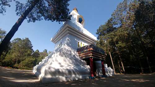
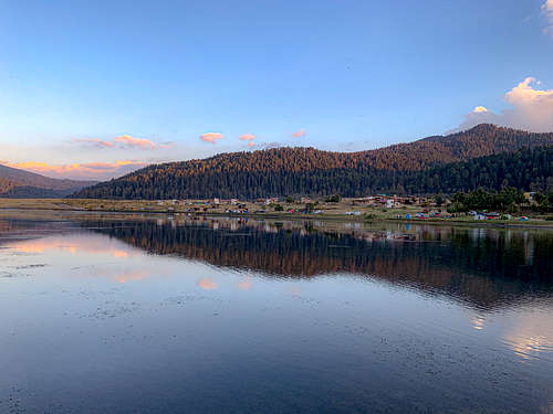
From that clearing to the cabins there is a drop of approximately 300 m. There begins the dirt road that will lead you through the great plains in the middle of the mountains, in whose center a dam was built, of important scenic beauty that belongs to the town of Corral de Piedra. Next to the dam, towards the west end, are the constructions of the ecotourism park, where services are offered to the public, including accommodation, food and a shop. You can choose to spend the night there, or walk another two hours to Amanalco or Valle de Bravo. The total distance can be covered in a whole day, the entire trail lasting 10 to 11 hours, so starting it at 10:00 a.m. is feasible after seeing the sunrise at Pico del Fraile at 4,686 masl at 7:00 a.m. A.M. The sunset will surely catch you in an open place and a wide celestial vault to see the sunset. If you arrive at the dam early, say, 4 in the afternoon or shortly after, you will be able to follow the uninterrupted paths towards the Great Stupa of Valle de Bravo, passing through some fragments of forest, and a town called “El Temporal”. The Stupa is a monumental religious construction that is located on the outskirts of Valle de Bravo, and characterizes the multiculturalism that predominates in the municipality. It is also possible to walk from the dam to Capilla Vieja, and from there go down to Amanalco if you want to return to Mexico City the same day or to go to the center of Valle de Bravo.
This route lacks extensive landscapes for most of its route, spending most of the mileage in the middle of dense forest, although if you pass through here after November, and before March, it is possible to see sites covered with Monarch butterflies (Danaus plexippus), for what it is worth, from my point of view, only in those months. It is from the Corral de Piedra dam where, on a clear day, the Xinantécatl can be seen some 30 km away, as well as the beginning of the Sierra San Antonio. In terms of physical exhaustion, of the two routes presented, it is the one that has the least impact, but it also presents more monotony in its landscapes.
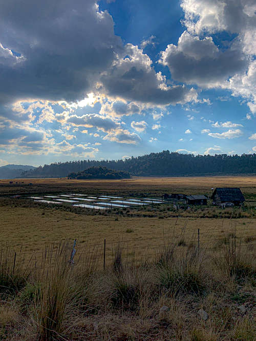
Route II. This alternative offers a challenging journey in terms of the unevenness that can be met in the entire route, rewarding with impressive views of Xinantécatl, the city and metropolitan area of Toluca and Zinacantépec; naturally, this last landscape full of smog due to the pollution emitted in the valley. The contrast is interesting when, in some peaks such as the San Antonio Volcano (3690 masl) the depression that encompasses San Francisco Oxtotilpan and the lands that sink into the rafts depression are visualized, in clean and clear air. The road begins in the town called Buenavista, at 3150 masl, where the bus conveniently drops you off. You walk along one of the many dirt roads that lead you to the one that goes up the hill, crossing a river. The attached GPS route shows the way out of the town, whose streets have no names or references. It won't matter much, since it's 5 minutes in which you cross the population center, to walk on a wide dirt road in the middle of cultivated fields, among which there are very few houses, until you don't even count one. Behind them, the Nevado de Toluca will dominate the landscape with more and more detail, although its size will decrease due to the distances that increase with the pace of the walk. A warning, from the beginning is that on this trail, water is practically non-existent, so what you take will be your only reserve until you reach Capilla Vieja, Amanalco or Valle de Bravo.
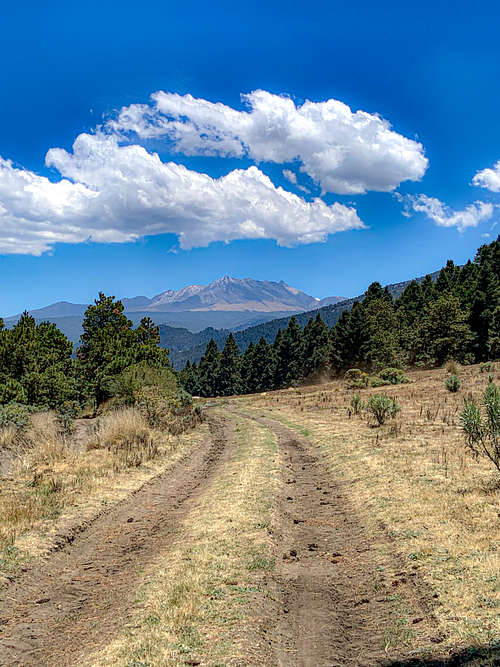
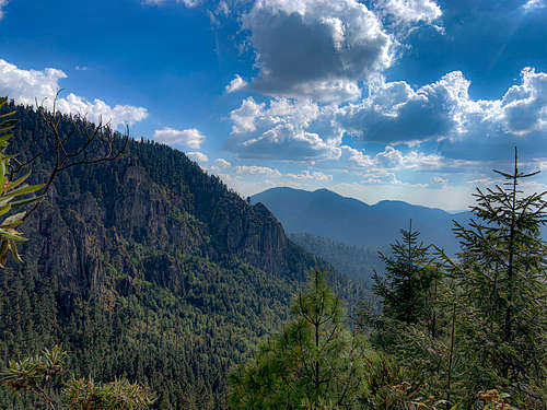
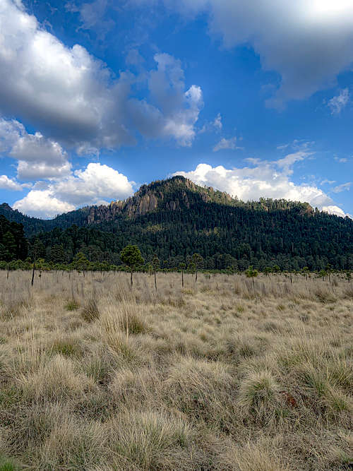
The exposure is, likewise, greater by passing on a road devoid of trees in a long stretch, the land adjacent to the road being cultivated areas or reforestation in growth. Despite the numerous curves, the path follows a southeast-northwest orientation in the first phase, with the direction to walk heading northwest. The road makes it pass in the middle of two hills of little prominence: the one of the wild boar and one without a name, being where the Xinantécatl will not be seen for a while. The height by then will be approximately 3350 meters above sea level. The course changes to the west, also increasing the slope, since it is necessary to cross a small hill to reach the highest part of the volcanic system. You will walk up to 3500 meters above sea level, in a Pinus hartwegii forest, characteristic for the less coverage offered by the trees, being a sparse and drier forest. If you take the trouble to deviate from the path and ascend towards the most prominent and outstanding peaks in view, you will see Xinantécatl in all its splendor. The forest, the truth be told, is one of the largest in central Mexico, combined with the high altitude and the enormous extension that the lavas of the volcanic group cover. The trees, however, show poor health. Forest exploitation in the area is active, so in the dry season it is possible to observe forestry operations in areas around 3,000 meters above sea level. The views in this part of the sierra only correspond to the south, since the north of the panorama will continue to be dominated by another part of the sierra, somewhat higher. Once you decide to continue the path, after ascending to the highest peaks of that part of the mountain range, you will have to turn north, through the same path that on this occasion will advance along the western slope of a huge hill. That road will cross a mountain pass, immediately turning northwest, taking it for a sustained drop, now until reaching 3610 masl, in a new mountain pass. The volcanic cone to the south is the one corresponding to the San Antonio volcano, the summit that gives the mountain system its name. Both the mountain pass and the summit of the cone are sites of religious worship to the Catholic god, so you will find crosses and perhaps religious images on both. The panorama from the top shows most of the mountain range, although not in its entirety. I suppose it is the most important peak in terms of the landscape it offers, its prominence and accessibility, and it may be the only peak that you ascend on your journey to get a partial view of your route.
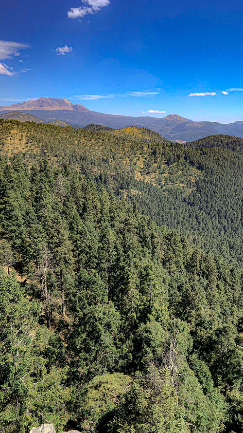
However, the culminating point of the sierra is located in the mountainous massif to the north of San Antonio, whose maximum point has an elevation of 3750 meters above sea level, and its panoramic view allows us to observe the north, totally deforested and inhospitable, except for the towns that in the altiplano are appreciated. On a clear day, the Xonacatepetl, which measures 3800 meters above sea level, is in sight. In short, an integral panorama, on the edge of the Toluca Valley and the lands that go into the east of the State of Mexico, towards Michoacán.
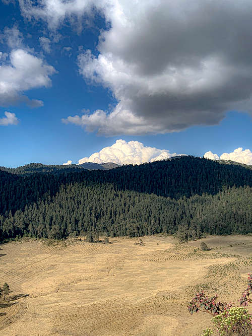
In any case, the path that will allow you to continue along the route descends from the pass between that great hill and San Antonio, passing through a ridge that will lead you to the next part of the volcanic system. Until then, the path will have been enormously exposed to the sun and, at times, to the wind. If the rain finds it in this phase, shelter will be in short supply. Continuing along the path, you will now enter an oyamel forest, which will lead you to a huge intermontane clearing, without the presence of springs. The landscape is peaceful and wide in its range of vision, so it is a good place to rest for a moment or eat. Not far away, you will intersect with the first route, which will lead you to the Corral de Piedra ecotourism park, and later to Valle de Bravo passing through a town called El Temporal, or towards Amanalco.
Essential Gear
It is necessary to wear hiking boots for the enormous distances that must be covered under different environmental conditions, where there may be dusty places, muddy places, grasslands, rocky roads and so on. Likewise, clothing should be made up of clothing, preferably with protection from solar radiation, although light and quick-drying. It would be important to carry a third layer of waterproof clothing and windbreakers in the backpack against inclement weather.
The food would be better if it consisted of energy bars and sweets, with bread and some dry item such as Serrano ham. For route I, it is better to carry 2 liters of water, due to the presence of springs along the way, where it is possible to recharge the bottles. For route 2, it is ideal to carry 3 liters of water, due to the greater exposure to the sun. It would be much better if of that amount of water, at least 1 liter were electrolytes or hydrating drinks. When going alone, it is important to carry GPS on a dedicated device or cell phone, since the routes have a complex physiography that allows you to easily get lost in the forest, or walk through the wrong gaps, since these are abundant due to logging. Route II is the gpx route included in the article, while route I can be found on wikiloc.
External Links