December 23, 2005 I needed to get out of the house and work on my conditioning. I live in Medford, Oregon and the snow on the higher peaks has not consolidated yet. I decided York Butte would be a good effort for today. It was an overcast day with patchy fog in the valleys.
I wanted to check out some hiking areas in the Kalmiopsis Wilderness Area because I hoped these summits would be snow free. The highest point in the Kalmiopsis is Pearsoll Peak at 5,098 ft and all the other summits in the area are obviously lower and hopefully accessible.
The drive along I-5 was uneventful and then I headed towards Galice after passing through Merlin. Driving along the Rogue River I noticed it was running high and colored a rich chocolate brown because of the rain we had during the last week. I found the single lane paced road up Briggs Canyon and Taylor Creek. Taylor Creek was running full and strong. It was very scenic indeed. Several feeder streams were pouring into Taylor Creek and they were all full with some waterfalls.
I passed several campgrounds and trailheads for hikes along Taylor Creek, but I kept going and passed Big Pine Campground. I turned up road 2512 towards Sam Brown campground and the road finally turned to gravel. This was easy driving and the road was fine. The road climbed up to Chrome Ridge and continued towards the Kalmiopsis. I knew I was getting close to the trailhead when I reached a saddle and the road split 3 ways.
I took the center road and it dropped down to Silver Creek. I knew I had taken the wrong road so I turned around and went back up to the saddle and took the left fork. I was soon parked at the York Butte trailhead.
I was using this as a training hike so I loaded up my big pack and headed down an old roadbed that was the designated trail for York Butte. I was surprised the 2002 Biscuit fire had left some trees unscarred. In fact most of the larger trees were only charred at the base and the tops were healthy and green.
I followed the roadbed for about a half mile where it approached the Kalmiopsis Wilderness boundary and then a nice trail continued. Walking along the trail I soon could see York Butte ahead of me. This part of the hike was easy because it was all downhill from the trailhead. I could see that I would have to regain all the elevation to get to the summit.
The low point of the hike was a saddle that connected the ridge I had been following to York Butte. The trail was a little difficult to follow through the burned snags, but it was obvious I had to cross the saddle to get to York Butte. The last 1/2 mile was a steep switchbacked climb up the north side of York Butte. The rhododendrons are coming back from the fire 3 years ago and they look like they will bloom next summer. I scared up several grouse that were hiding close to the trail. They should be called Heart Attack birds because they always take off when you least expect it.
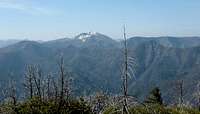
On the summit, the views were good. They would have been better on a clear day, but they were enjoyable with cloud cover too. I could see Mt. McLoughlin peeking out under the clouds way to the east . It was in sunshine, so I know the weather was better at home in Medford. The Chetco drainage was fog filled and it looked picturesque.
I didn’t stay long at the summit and I was soon heading back down the trail to the car. Climbing back up from the saddle to the trailhead wasn’t difficult. It only took 1 ¾ hours for the entire hike. The drive back out on the single lane roads were uneventful and when I got to the Merlin/Galice Road I realized I had not seen another car, camper, or person since I turned up this road earlier. Overall this was a great hike in a very scenic area
Comments
No comments posted yet.