
-
 1604 Hits
-
 76.66% Score
-
 7 Votes
|
|
Route |
|---|---|
|
|
47.06838°N / 14.55617°E |
|
|
Download GPX » View Route on Map |
|
|
Hiking |
|
|
Spring, Summer, Fall, Winter |
|
|
Half a day |
|
|
Easy hike up |
|
|
Overview
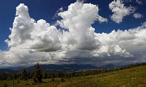
On the western slopes of Zirbitzkogel
General Information
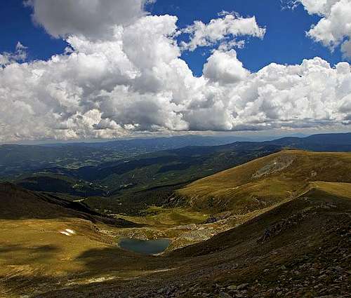
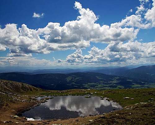
En route, below is Lavantsee
Difficulty: It's an easy hiking tour. On the Swiss Hiking Scale its difficulty would be graded T2. The majority of route could be even graded T1, only in the upper part there are a few steeper sections. In times of tour skiing this is also a nice and popular ski tour.
Orientation: The route is all the time well marked. If it's only a fair visibility, you even don't need a map.
Orientation of slopes: All the time W and S, only just before the summit hut there is a short crossing of (a bit steeper) E slopes.
Best season: Any time of a year. If you choose months when Tonnerhütte is closed, then the ascent is more than 1 h longer.
Gear: Good shoes and poles are better than just only low sport shoes.
Tour start: Tonnerhütte, 1600 m. Big parking place there. The fee for parking is 3 EUR (2016), but you can consume that value in the hut - it gives you almost a beer or a soup.
Highest point: 2396 m.
Altitude to overcome: Ca 800 m.
Time for ascent: 2 h 30 min (officially). It's also some distance and the trail goes slightly around.
Getting There
Tonnerhütte is a nice complex of private houses on the altitude of 1600 m. Good mountain road will bring you there in times of season, when the hut is opened. The mountain road starts in Mühlen (good inscriptions on plates), the village, lying on the road 92. You get there either from Neumarkt in der Steiermark (lying on the main road 317), so from the NW, or by the road 92 from the south, from Brückl. It looks that the mountain road to Tonnerhütte is cleaned also in times of tour skiing (Dec-April), but coming with winter equipment for car is a good idea (the road is steep on some sections).Route Description

Towards Zirbitzkogel

Resting place above the timberline
From Tonnerhütte you follow the inscriptions towards the E, directing you towards Zirbitzkogel. The marked trail soon leaves cart roads and guides you up by a short ski slope. Above it, you can learn a few most interesting features of the nature in this area - as we are in the Naturpark Zirbitzkogel-Grebenzen. In 30 minutes we reach out of nice forrests and soon above the timberline there is one of the most inviting resting places - made by man. It's a big round plateau with plexi glass walls (wind protection), equipped with wooden beds and chairs in various forms. The broad panorama is explained in detail and there is a lot of information about nature there. Panorama is immense already from here, even if we are only on 1800 m. On the return you can hardly resist to have a nap there.

Towards the S ridge

The summit and its hut from the S
The continuation of the route is now clearly ahead of us. In the beginning, the slopes are only gently rising. The path goes all the time towards the E-NE, but when reaching below the steeper (and rocky) summit slopes it starts turning right. In a comfortable ascent we cross all the S slopes of Zirbitzkogel, approaching the ridge between the highest point and the gentle southern lying Fuchskogel, 2214 m. We reach the ridge quite above the lowest point and there we turn sharp left. A broad panorama opens towards the E, especially nice is the view down on Lavantsee.
From the ridge we already see the summit hut. It sooks close and indeed we don't have more than 20 min till there. The path goes at first close by the ridge, but higher it crosses the eastern slopes of the highest point, going to the hut first. There we turn left again and ascend the highest point in a few minutes.

Here we tun left down
Descent. The big majority of visitors who ascended from Tonnerhütte return by the same route. But that's not the only option. Nice is also to do a little round tour in the upper part. We can descend towards the NW, towards Scharfes Eck and there we have two options. The shortest return options turns left already on the first saddle (by a big, picturesque rock). A table directs you across a grassy slope, then you just follow poles directly down. There's no good path, I guess this is the alternative route for a ski tour descent. The other option is to continue a bit more by the narrow mountain road and later turn left by a good marked path.
Descending by the western slopes
External Links
Naturpark Zirbitzkogel-Grebenzen: http://www.natura.at/startseite.htmlTonnerhütte: http://www.tonnerhuette.at/