


Comments
No comments posted yet.
|
|
Trip Report |
|---|---|
|
|
Jan 1, 2015 |
This is just a simple log to keep track of our 2015 trips.
See the 2014 Trip Log for 2014.
See the 2013 Trip Log for 2013.
See the 2012 Trip Log for 2012.
See the 2011 Trip Log for 2011.
See the 2010 Trip Log for 2010.
See the 2009 Trip Log for 2009.
See also the 2008 Trip Log for 2008.
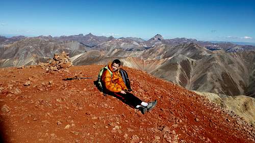
December 24-December 27: Elk Mountain/Jacque Peak (Colorado)
December 24
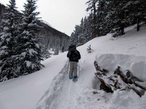
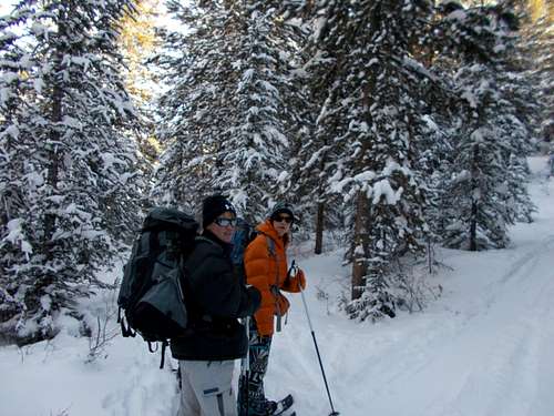
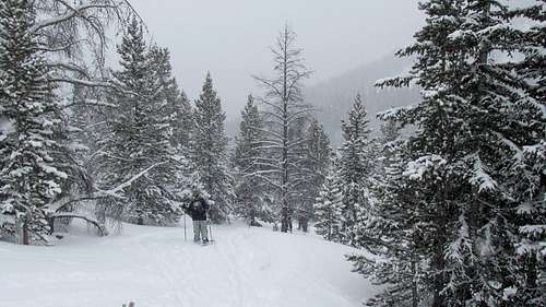
After a challenging drive through a blizzard the night before, Kim, Kessler, Shaylee, and I started up towards Janet's Cabin, one of the 10th mountain division huts. Under cloudy skies, we tried to snowshoe fast because of the approaching storm. It was a very cold storm system and it was definitely quite cold on the approach.
Since we were on snowshoes, we had to hike up through the Copper Mountain resort before finding the route into the dense forest and up the valley.
We made good time, stopping only once since it was too cold to stop for very long anyway. We arrived at the hut just before the storm hit.
We were worried about the avalanche danger for the peak climbs, so we decided to use careful route selection and to check conditions carefully.
December 25
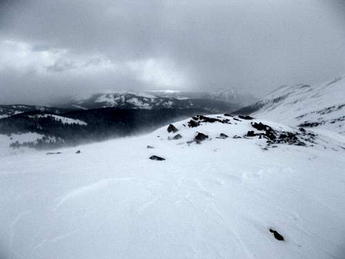
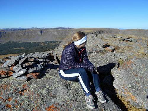
The weather was very cold and stormy, with poor visibility and snow falling, but I wanted to get out and climb Elk Mountain and Sugarloaf Peak. No one else wanted to go, so I set up alone. The trail was broken by some skiers up to a hill above the hut. Above that, I broke trail up to Searle Pass and then the conditions became brutal with the high winds. The chill factor was around -40F/-40C on the new chart, but it was still snowing horizontally.
I made my way up the ridge towards Elk Mountain with poor visibility, but every once in a while I could see part of the mountain briefly. Even though visibility was poor, I could see what I took for a very steep slope or cornice on the way to a false summit, but when I got there, it turned out to be not bad. I made my way over the false summits and to the final push up Elk Mountain, which was quite steep considering the conditions.
At the summit of Elk Mountain, I didn't get any views and decided not to continue any further. I couldn't see anything and was worried getting lost in the whiteout. Besides, it was absolutely brutal and I was freezing cold.
I descended the same way. One the way back, there were several snow slumps, but that was in areas not steep enough to slide. I avoided any slide danger by staying on the ridge-tops for the ascent.
The evening was spent playing games (mostly) Uno, telling stories, and having a good time.
December 26
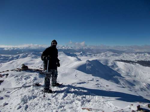
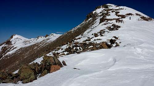
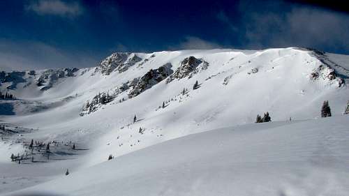
We awoke to -24F (-31C) at the mountain hut. The skies were mostly sunny though. Kessler and I set off for the summit of Jacque Peak, 13,211 feet/4027 meters elevation.
Since I had broken the trail to Searle Pass the day before, we made faster time to the pass than I did on the previous day. Once we were at the pass, it was windy and cold again.
After a very brief break at the pass to get some water, we headed up the ridge towards Jacque Peak. The ridge had pretty good snow conditions, but there were a few places where the snow was deep and a few place where the wind had blown off the snow leaving exposed rock.
Kessler was moving faster than me, but he would have to find a place sheltered from the wind in order to wait for me since it was so cold.
The ridge seemed much longer than expected and when we got to the major false summit (almost a mountain in itself), at 12,660 feet, it was disheartening to see how much further the summit still was. We also had to descend a fair distance before climbing up towards the true summit.
The route to the summit was also more difficult than we expected and we had some steep rock scrambling, which was tedious since there were areas of soft snow between the rocks.
Eventually we made our way up another false summit and to the true summit. It was a hard earned summit, but the wind was just screaming. I calculated the windchill to be -54F (-48C) on the new chart and -81F (-63C) on the old!
We didn't spend much time on the summit, but got a hot drink (we had brought it up in a thermos) and ate a very brief lunch. Other than our brief break at Searle Pass, this was our only rest.
The views were absolutely spectacular and we could see much of the Gore Range and Sawatch, as well as the other surrounding mountain ranges. Still, with the cold, we didn't spend much time on the summit. We headed back down the mountain using the same route, but we found a better way through the rock scrambling section and avoided much of it.
It was a very spectacular climb, but very cold, and the ridge was much longer than we thought it would be. The rest of the group was happy to see us when we stumbled into the cabin.
It stayed well below zero all day, even at the cabin.
December 27
It was still cold, but not nearly as cold as the day before. The temperature even rose above zero. We packed up and had a sunny snowshoe down the packed trail and to the vehicle.
It was a bit chilly at times, and the trip was challenging, but it was still a great experience.
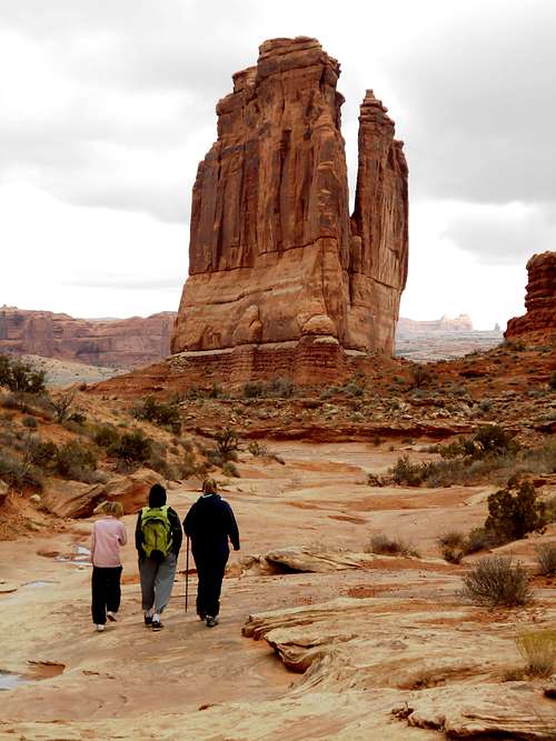
December 20: Devils Garden/Primitive Loop (Utah)
Shaylee, Kessler, Kimberly, and I hiked the Devils Garden and Primitive Loop in Arches National Park. Parts of the route were a little bit dicey due to ice. We also did the side trip to Pine Tree Arch and Tunnel Arch. It was a great trip, but I was dragging since I have a bad cold.
December 19: Delicate Arch/Un-named Butte (Utah)
Shaylee, Kimberly, Kessler, and I hiked to Delicate Arch in very icy conditions. Kessler and I also climbed a high un-named butte in the area for the views. The final pitch was a bit icy and exposed, but it was a good day.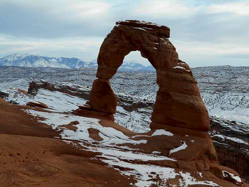
December 13: Windows, Eye of the Whale (Utah)
Today I hiked all the trails at the Windows in Arches National Park. After that I drove to Eye of the Whale and hiked to that arch. I drove out via Willow Springs road.
December 12: Chicken Corners/Catacombs/Hunter Canyon (Utah)
It was a long day, but I probably spent more time in the Pathfinder than on foot. First I drove the Chicken Corners 4X4 route and hiked the trail around the corners. It seems scarier than earlier times I have done it.
I also tried to drive up Hell Hill, but I couldn't make the last few obstacles.
After that, I stopped to check out the Catacombs. I found a class 4 winding route up to the top of the butte. I left a tiny cairn at one location so I could find my way down. After that I explored the Catacombs.
I also climbed an un-named butte on the way to Jackson Hole, which I also drove to. I didn't think I would have enough time to do the Jacksons Ladder route, so I didn't attempt to hike/climb it.
After that, I hiked Hunter Canyon. It was dark by the time I got out, so I didn't get to look for all the petroglyph panels along Kane Creek. Some other time.
Unfortunately even though I saw lots of spectacular scenery today, I left the camera home. :(
November 29: Park Avenue (Utah)
Shaylee, Kimberly, Kessler, and I hiked the Park Avenue Trail in Arches. Since we didn't have a car shuttle, we reversed the route. It was chilly and windy.
We also visited the short trail at the Dinosaur Tracks Museum near Moab.
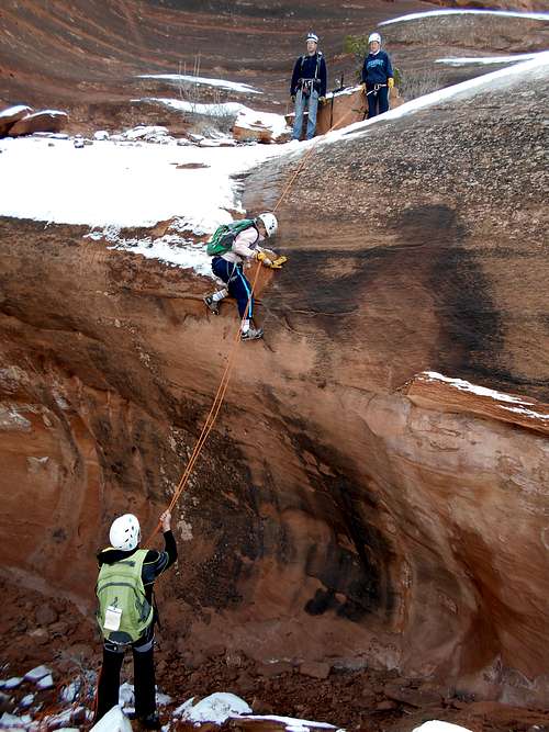
November 28: U-Turn/Courthouse Wash (Utah)
Shaylee, Kessler, Kimberly, Jon, Dana, and I did the U Turn (technical canyon)) Route in Arches National Park. Much of the route was treacherously icy and we had to do an alternate rappel in one location. It was part climbing, part "sledding" (without the sled), part sliding on ice, and part rappelling.
After completing the U Turn, Kessler, Shaylee, Kimberly, Jon, and I completed the lower Courthouse Wash Hike, hiking from Arches National Park to near the Colorado River. Since we didn't start until 2 PM, we had to move rather quickly in order to complete the route by dark.
November 27: Granary Canyon (Utah)
Kessler, Jon, and I completed the Granary Canyon route near Moab. I had wanted to do that canyon since I hadn't done it before. We did all of lower Granary and half of upper. Conditions were pretty good, and we could do some tricky traversing to avoid most of the water, but there was one ice covered knee to waist deep pool to wade. It was still a good trip though.
November 26: Wall Street/Corona Arch (Utah)
In the morning through early afternoon, Kessler, Kimberly, Shaylee, and I did some climbing on Wall Street. We did several routes and the kids led all of them.
In the afternoon we all headed to and hiked to Corona Arch. It was a nice sunny day and relatively warm.
November 25: Dinosaur Hill (Colorado)
On the way down to Moab, Kessler, Shaylee, Kimberly, and I stopped to hike the Dinosaur Hill loop near Fruita.
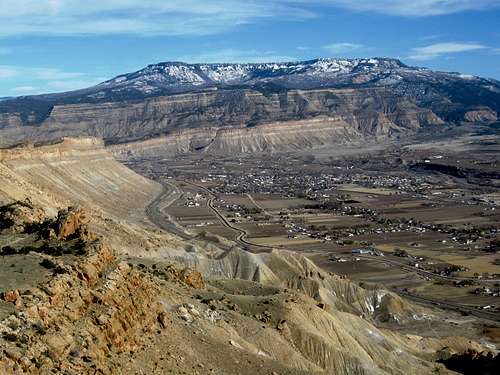
November 22: Mount Garfield (Colorado)
It was cold and breezy when Kessler and I started up the mountain, but things warmed up as the sun got higher in the sky. We had a nice climb up Mt Garfield, making the summit in just over an hour. After exploring around and eating a snack on top, we descended to the saddle and then climbed East Garfield before following the east ridge and then a wild horse trail down to the valley at the mid-point of the main trail. We descended the main trail the rest of the way down. It was nice and warm and the wind had disappeared.
Until we got to near the bottom, we had the mountain all to ourselves.
November 21: Riggs Hill (Colorado)
Around sunset, Kessler and I hiked up Riggs Hill and visited all the points on the hill.
November 15: Cedar Mountain (Colorado)
Kessler and I climbed Cedar Mountain, using the northern half of the loop trail and returning the same way.
November 13-14: Points 12,179/12,391 (Colorado)
November 13
Alone, I snowshoed up to the Broome Hut near Berthoud Pass by headlamp starting at 9 PM. The hut was deserted except for me.
The temperature in the morning was 11F and completely sunny. After a quick breakfast, I broke trail up to the ridge and climbed over Points 12,179 and 12,391 before dropping down to Berthoud Pass. It was a neat trip, but more difficult than expected since most of the time it was all virgin snow. I had to carry my overnight pack over the top too.
The skies were completely sunny and it was windless and quite warm for the time of year.
November 8: Dinosaur Hill/Devils Canyon (Colorado)
Kimberly, Kessler, Shaylee, and I hiked Dinosaur Hill in the morning and then the Devils Canyon loop in the afternoon. The morning started out cold and windy, but it warmed up quickly and was a beautiful day.
November 1: Sand Rocks (Colorado)
Shaylee, Kessler, Kim, and I took a night hike over the top of the Sand Rocks.
October 31: Quandary Peak (Colorado)
Shaylee and I attended the 14ers.com gathering in order to climb Quandary Peak. It was a very windy day, which made it feel cold. Since Shaylee is only 55 lbs., the wind blew here around quite a bit and we were often enveloped in clouds. Other than that, it was a routine climb to the summit. It was a good climb. We made it to the top in less than four hours and took less than two hours to descend.
October 25: Cedar Mountain (Colorado)
Alone, I climbed Cedar Mountain, completing the long loop. I had expected to come down by moonlight, but the clouds obscured the moon, so it was really dark on the descent.
October 24: Cedar Mountain (Colorado)
Shaylee, Kessler, and I completed the long loop on Cedar Mountain. It was a beautiful day. We saw many deer and a few rabbits.
October 18: Lakes Trail (Wyoming)
It was misty and windy when Kimberly, Shaylee, Kessler, and I woke up at the Sugarloaf Campground, so we parked at Lake Marie and hiked the lakes trail to Mirror Lake and a bit beyond.
October 17: Medicine Bow Peak/Sugarloaf Mountain (Wyoming)
Kessler, Shaylee, Kimberly, and I climbed Medicine Bow Peak in Wyoming today. It was very warm for October and I didn't even need a jacket on top. After enjoying the summit, we descended a bit and I wanted to climb Sugarloaf Mountain, but the others didn't. The others continued their descent while I climbed Sugarloaf Mountain. I didn't spend much time on top since clouds were gathering, so I descended as it started to thunder. There were some short lived snow pellets, but that was it. We saw several pikas on the hike and a fox in camp. It was a good climb.
October 11: Cedar Mountain (Colorado)
I took an early evening hike up Cedar Mountain, completing the short loop.
October 10: South Fork Buckwater Draw (Colorado)
Shaylee, Kessler, Justin, and I went through the South Fork Buckwater Draw. The weather was great and as always, the slot canyon was nice. It was quite dry this time and without much water or mud. We did get our rope briefly stuck at the first rappel, but other than that things went smoothly.
October 8: Colorado Mines Peak (Colorado)
On the way back from taking a test in Denver, I made a quick run up Colorado Mines Peak. It was a beautiful day and warm for the time of year. I only had to walk through a little snow.
October 4: Handies Peak (Colorado)
Kessler and I climbed Handies Peak with a group of 14ers.com members. We didn't start until after 9 am. We wanted to get over the mountains before it snowed, so we moved rather quickly. Kessler and I made the summit of Handies in one hour and 30 minutes. After a break on top, we were back at the vehicle in three hours. We drove over Cinnamon Pass and then to near Engineer Pass and then Ouray. We should have came down the road to Silverton since the road to Ouray was very rough and time consuming.
October 3: Redcloud Peak/Sunshine Peak (Colorado)
Kessler and I climbed Redcloud and Sunshine Peaks. We got a late start and moved quickly, climbing Redcloud in about two and a half hours. We hiked the ridge to Sunshine Peak and came down the Sundog Ridge. Kessler wasn't feeling well, so we bailed off the ridge early. There was a lot of scree and one 5th class downclimb, so it may have been better if we had just stayed on the ridge. The two peaks took six hours round trip.
September 27: Wood Camp Hollow/Jardine Juniper Trail (Utah)
Shaylee, Kimberly, and I hiked up Wood Camp Hollow towards the Jardine Juniper. We didn't have time to go all the way to the juniper though. After getting just over half way to the juniper, we had to turn back.
September 26: Wellsville Cone/Box Elder Peak (Utah)
I had made a non-refundable hotel reservation in Logan Utah, for a wedding we were to attend, but the wedding changed dates. We decided to go anyway and do some peak bagging. Shaylee, Kimberly, and I set off to climb Wellsville Cone and Box Elder Peak from the Coldwater Trailhead. It was a more rugged trip than expected because the trail is steep, eroded, and brushy. It took a while to get to Stewart Pass.
Once at Stewart Pass, the trail was a bit better. Kim and Shaylee stopped at the summit of Wellsville Cone and returned to Stewart Pass, while I went on alone to climb Box Elder. I met them both at Stewart Pass and we descended down to the trailhead.
It was a more rugged trip than expected! After climbing the peaks we went to Chuck-A-Rama and saw the Everest movie to celebrate.
September 23: Sand Rocks (Colorado)
Kimberly and I did an evening hike to the top and then over the Sand Rocks.
September 19-20: Orno Peak (Colorado)
September 19
Kim and I started in the afternoon and hiked to Black Mandall Lake, where we set up camp. The autumn leaves are coming out and should be peaking in a week.
Kim didn't like the stream crossings, but it was a good hike to the lake. It was a bit breezy at the lake, but still sunny.
September 20
We woke up to a 29F morning, which isn't that bad for late September at this elevation. At first light we started up Orno Peak. It was chilly and windy, but the skies were clear and we made our way to Mandall Pass and then the summit.
At the fore summit, Orno Peak looked formidable, but it was actually an easy class 2 climb. After enjoying the summit we returned the same way, packed up camp and headed for home. It was a great trip.
September 13: Lookout Mountain (Colorado)
After a very frustrating 1/2 a day at DIA, and after picking up my daughter, I had to do a short hike to vent my frustration. On the way back home, Shaylee and I stopped at Lookout Mountain and hiked the Nature Trail Loop and the Forest Loop. We saw some of the strange pointy eared squirrels, but not much other wildlife. After that we left for home.
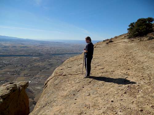
September 12: Mount Falcon (Colorado)
Today I climbed Mount Falcon. I climbed from the eastern trailhead since it's more of a hike from that direction. I went up the Castle Trail, where I almost stepped on a rattlesnake that bluff(?) struck at me and rattled.
Along the way, I made side trips to the little summits of Walkers Dream, Two Dog Trail, Old Ute Trail, and Devils Elbow. Even though the summits weren't ranked, I wanted to visit them all.
In the summit area, I went up the Meadow and Tower Trails and down the Castle Trail. I had a nice break/lunch on top.
After that I descended the Castle and Turkey Trot Trails back to the car park. I figured I did just under 11.5 miles with all the side trips.
September 11: North Table Mountain (Colorado)
Late morning and afternoon, I hiked up North Table Mountain near Golden. I went up the Golden Cliffs Trail, to the North Table Loop, along the Tilting Mesa Trail and then climbed Lichen Peak. After that I followed the Tilting Mesa Trail to the Rim Rock Trail and completed that loop. Since the east trail to the North Table Trail was closed, I hiked the Mesa Top Trail back to the Tilting Mesa Trail and backtracked my ascent route. I believe I covered about eight miles including a few side trips on spur trails and overlooks. It was a nice hike and luckily not a hot day.
September 7: Fossil Butte (Wyoming)
Kessler and I spent the night in Kemmerer and decided to check out Fossil Butte National Monument since we had never been there and didn't know much about it. Since the visitor center wasn't open early in the morning, we hiked the Quarry Trail Loop which climbs to the old quarry and almost reaches the summit of Fossil Butte. Since we didn't know if off trail travel was allowed, we just hiked the loop and didn't go to the summit.
After hiking the trail, we visited the visitor center before heading home.
September 6: Borah Peak (Idaho)
Kessler and I climbed Borah Peak today. Since we were rather sleep deprived, we didn't get as early start as we wanted and left at 6:30 AM. It was just getting light, so we didn't bother bringing the headlamps. Luckily it wasn't nearly as windy as the day before, but it was still fairly cold for the time of year.
The climb went faster than expected and we made our way to Chicken Out Ridge. We passed several people, but only one passed us.
Since the sun was hidden behind the mountain until we hit Chicken Out Ridge, it was quite cold. There was moisture in the air and my hait kep freezing and some of the rocks were covered with verglas. There was a little fresh snow as well. We stayed warm, but I wished that I had brought the gloves because the rock was very cold on our bare hands. Luckily the exposed sections weren't to iced up.
We went right over the Chicken Out Ridge without any trouble. After that, it was just a steep scree hike to the summit. We made the summit in 4 hours 22 minutes, at a moderate pace. The views were great and the wind had nearly stopped when we were on the summit. Two climbers who just left the summit told us that it was really windy, so we got lucky. There was a squirrel right at the summit which was intent on eating climber food. Hopefully it descends and finds food for the winter.
The summit had a flag and rocks that were coated in ice and hoarfrost, but it was a pleasant scene. After enjoying the summit for a half an hour or so, we descended. Most people must have turned back at Chicken Out since we only saw one group that we passed on the way up. This time we saw and took the bypass trail around the Chicken Out section, but it was unpleasant scree and I think the ridge itself is a better route.
We were back at the car 8 hours and 15 minutes after starting. It was a good climb.
September 5: Inferno Cone/Snow Cone/Spatter Cones/Broken Top/Tree Molds/Lava Tubes (Idaho)
I had to drop off my daughter in Boise, so Kessler and I decided to take the slightly longer way home and do some hikes and climbs on the way home. We didn't arrive at our destination until around 2 AM and we didn't get much sleep at my sister in law's house that night since cats kept jumping on our face when we were sleeping on the floor. We left just after 7 AM.
We drove to Craters of the Moon National Monument and did all the hikes we could before it was time to push on to Mackay (Idaho). It was extremely windy and we were worried about climbing Borah the next day. As soon as I set my backpack down it blew away and I had to chase it!
First we hiked up Inferno Cone (which was smaller than I thought it would be), then we hiked around and up Snow Cone and the Spatter Cones before going to and hiking the Broken Top Loop (which happened to be the best of the hikes). With headlamps, we explored the Buffalo Caves as well. We also did a side trip to the top of one of the cinder cones.
After the Broken Top Loop, we hiked the trail to the tree molds which were made when hot lava hit some live trees. We then did the Caves Trail and visited all the caves except for Boy Scout (time ran out), but we thought the Buffalo Caves were neater.
After hiking all those trails, it was time to go. It was a good day, but we were very tired after driving to Boise and getting almost no sleep.
August 29-30: Lost Lakes Peaks/Devils Causeway
August 29
The original plan was to climb Snowmass Mountain, but the weather forecast was bad on the 30th, so Kessler and I decided to climb the Lost Lakes Peaks and Devils Causeway instead.
We got a pretty late start and we had a long day ahead of us, so we moved rather expeditiously. We started at Ripple Creek and followed the Chinese Wall trail to near the Lost Lakes Peaks and climbed both of them. The east peak was a spectacular one with a great view down a huge drop. We then headed for the Mosquito Benchmark. The trail was mostly faded along the gentle ridge. One marmot was seen along the way. We climbed the Mosquito BM before heading over to and climbing over the spectacular Devils Causeway. The Causeway was interesting with a big pack. Another marmot was seen along the way.
We camped at a nice little spring at the base of the Causeway and at 10,800 feet. It was a long day!
August 30
Since we packed in a hurry, we forgot our sleeping pads and it was a long night. I was also congested and I didn't bring any medication.
We woke up tired and headed along the trail visiting Causeway Lake, Long Lake, East Lost Lake and West Lost Lake. We made it to the trailhead at 2 PM. It started raining and hailing at the end, but luckily we were almost to the car by then. With climbing the peaks and no sleep, we were tired after the 26 mile hike.
August 24: Sand Rocks (Colorado)
Kessler and I took a hike over the Sand Rocks.
August 23: Cedar Mountain (Colorado)
Kessler and I made an evening climb of Cedar Mountain, completing the long loop. The sky was still very smoky, but it made for a spectacular sunset. We saw many rabbits and deer on the hike.
August 22: Black Mountain (Colorado)
Shaylee, Kimberly, Kessler, and I all climbed Black Mountain. Kim worked her shift first and we got a late start. We climbed from the Southeast Ridge route, climbed to the east summit and then went all the way to the west summit. The weather was cloudless, but there was quite a bit of smoke in the air. We saw many grouse and some raptors as well.
August 15: Dry Canyon (Utah)
Kessler and I hiked up Dry Canyon near Logan. It was a very warm day. We had a wedding to go to in the afternoon, so we didn't have time to climb all the way to Logan Peak.
August 11: Williams Fork Mountains (Colorado)
I took an afternoon hike up one of the un-named peaks in the Williams Fork Mountains.
August 9: W Mountain (Colorado)
After driving the rough 4wd road to the Big Springs Trailhead the night before, Kessler and I set off early to climb W Mountain. We didn't find the beginning of the trail (the map is misleading), but we followed cow trails into East Fork of Red Dirt Creek, where we found the trail. The trail was pretty easy to follow up to the first saddle, but we lost it there and only found scraps of it up to timberline. Once above timberline, the route was easy to find.
The views and weather were really nice from the summit. It was hard to tell where the true summit was since there are a bunch of little bumps and rock piles on the rolling summit area.
We saw and heard pikas and two marmots. After enjoying the summit, we returned most the same way, but found the official trail on the way back. There were a few mosquitoes and a few biting flies, but no other unpleasantness.
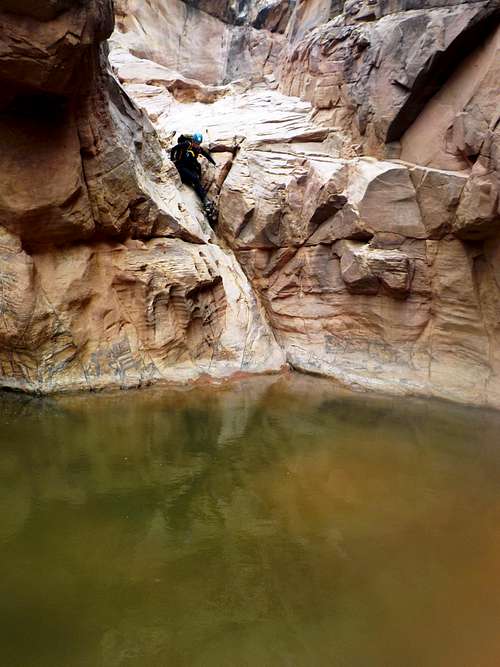
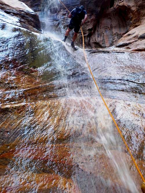
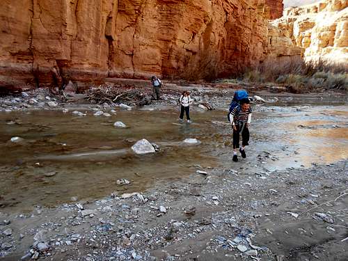
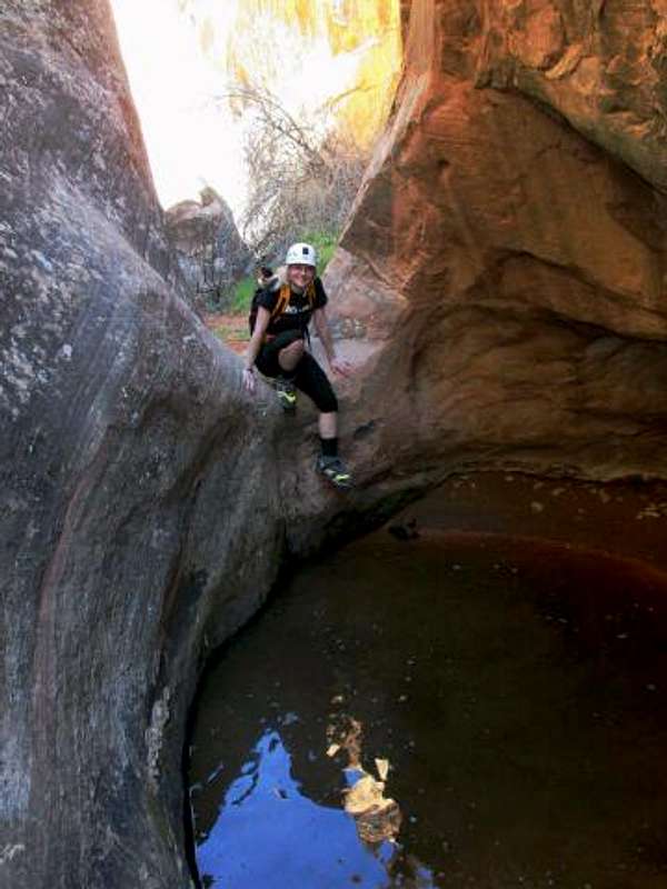
August 2: Green Pool Canyon/Upper Black Box (Utah)
Mindy, Julie, and I wanted to check out a new route into Upper Black Box. We descended a side canyon of the Black Box and got to do the best part of the Box. Others have used this side canyon and I had it scouted out back in 2002, but still hadn’t descended it yet.
We descended the side canyon and found it to have several fun down climbs and one huge green pool, thus I decided to refer to the canyon as Green Pool Canyon. There was one rappel over a huge boulder jam and then some fun scrambling through a slot. The final rappel was a spectacular one and was where the slot canyon mysteriously ends on a bench.
Although the weather forecast was good, the sky was cloudy, so we hurried through the Upper Black Box. It even rained a little, but it wasn’t enough to make the water rise. The Upper Black Box is a fun summer waterpark, but there was more mud in there than on previous trips.
It was a great trip, but the road to the trailhead took longer than expected, so it was very late by the time we drove home.
August 1: Three Fingers Canyon (Utah)
Kim, Kessler, Shaylee, and I met Julie and Mindy on I-70 and headed down the 4wd road to Three Fingers Canyon. It is one of the few “betaed” canyons that I haven’t done in the Swell. It was August, but the canyon had a lot of swimming making it pleasant. The canyon has a fairly long approach and exit for a fairly short technical section, but the hike in and out is pretty scenic.
There were a lot of fun obstacles in the canyon and because the canyon was full of water, we only had to do one rappel. There were some nice jumps into deep water.
The canyon was longer than expected and took longer than expected, but was still nice. The exit hike out wasn’t that bad either. It was a fun day.
July 27: Sand Rocks (Colorado)
I made an evening hike over the Sand Rocks.
July 25: Central Front Range Peak (Colorado)
Today, Kessler, Kimberly, and I hiked what is known as the Zirkel Circle. Kessler and I also took a side trip from the pass to climb the Central Peak of the Front Range.
We hiked up Gilpin Creek to beautiful Gilpin Lake. From Gilpin Lake, we hiked to Gilpin Pass where Kim waited for Kessler and I while we climbed Peak 11164/Central Peak Front Range.
We under estimated the peak. The knife edge and blocky ridge eventually became technical so we backtracked and dropped off the south side of the ridge. We followed the base of the cliffs west until we could climb up to the ridge again. We then made our way to the summit.
We found that there was only one other signature in the register in the past 15 years. After enjoying the summit views, we descended back to the pass. the climb took twice as long as we were expecting. It took us an hour round trip.
We descended into Gold Creek and then followed the Gold Creek Trail past Gold Creek Lake and the falls and back to the trailhead. We got wet at the stream crossing, but it was a great hike.
July 23: Sand Rocks (Colorado)
I took an evening hike over the Sand Rocks and saw several deer.
July 22: South Castor (Colorado)
I made an evening climb of South Castor Peak in nice weather.
July 19: Pipeline Trail (Utah)
Kessler, Shaylee, and I hiked the Pipeline Trail Church Fork to Rattlesnake Gulch (Wasatch Range) before driving back home. Luckily the day wasn't as hot as normal.
July 18: Reynolds Peak (Utah)
Alone, I climbed Reynolds Peak from Dog Lake and Big Cottonwood Canyon. I hadn't climbed the peak since May of 1996.
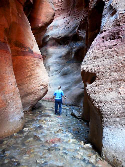
July 12: Reid Nelson Draw (Utah)
Julie and I (the rest of the group was beat from the day before) hiked Reid Nelson Draw in the San Rafael Swell. Because of previous rains, the whole canyon was filled with water and there was much swimming and wading.
We made it down to Crawford Draw before backtracking until we could climb out of the slot and follow the rim back to the vehicles.
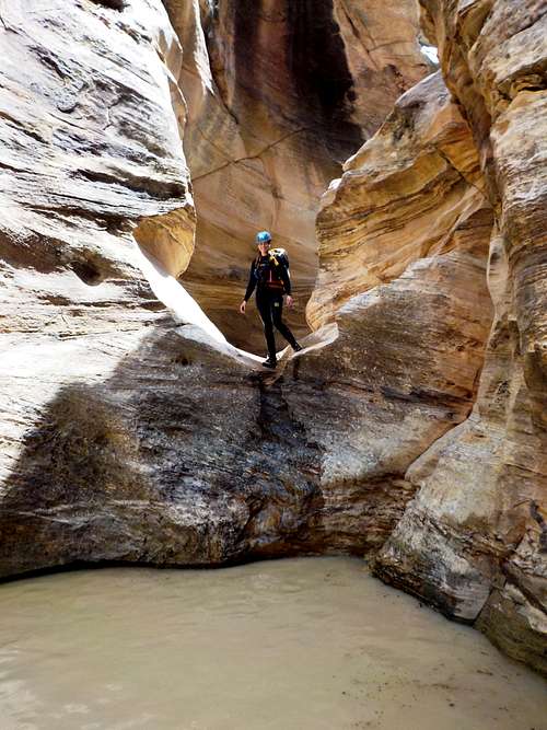
July 11: Eardley Canyon (Utah)
some friends (Julie, AJ, Heather, and Mindy) and I headed for the Upper Black Box.
We chose this weekend since we checked the flow online and since the weather forecast was good.
The online CFS were 39 when we left home, which is good to do the Black Boxes. We camped by the river and it did not rain where we were. During the night, the San Rafael River shot up to ~900 CFS, according to the online data.
Somewhere up canyon must have had a h*** of a storm. It also takes a while for flood waters to reach the Black Boxes if they started near the headwaters. In the morning we say that the river was high. I waded in a bit and said that the current was too strong and we decided to wait to see if the river would drop. We waited around a bit and concluded that it wouldn't be safe to do the Black Boxes and we did Eardley Canyon instead (Eardley was flowing, which made an interesting trip-we waited for clear skies to do it).
Anyway, it sprinkled a very little (the weather forecast was good and didn't predict rain), but other than that it didn't rain on us.
We chose to do the car shuttle route into Eardley Canyon since I thought it would be too hot for the standard route since we didn’t start down canyon until afternoon. Mother Nature has taken a big toll on the access road though and they are rough and slow. I don’t know if I’d do the car shuttle route again.
We didn’t have a map of the access route (since we weren’t planning on doing this canyon), but I used landmarks to get us to the head of the access gully. The gully down was nasty, as always, but we reached the canyon floor without any problems. We were in the canyon bottom at 5 PM.
We found out that the canyon was flowing, something I’d never see it do before. We continued down canyon, and had several swims before reaching the technical section. The technical section had many nice waterfalls and was very beautiful due to the running water.
We made our way through the canyon and reached the trailhead right at dark. By the time we retrieved the shuttle vehicle and were back in camp, it was midnight.
July 5: Kanarra Creek (Utah)
Kim and I hiked up Kanarra Creek. What a beautiful hike! It was lovely on a hot day and the water was perfect for cooling off in. We went up past the two ladders and to the end of the narrows. It was a great hike, after which we drove back home.
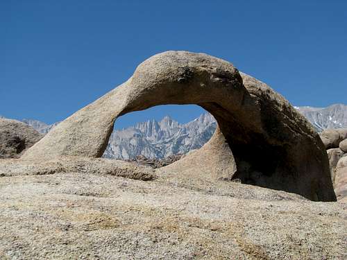
July 4: Alabama Hills/Mobius Arch (California)
Since Kessler, Shaylee, and my dad were hiking the John Muir Trail (Bishop to Yosemite), Kim and I separated from them. In the morning, we hiked to Mobius Arch and other arches in the Alabama Hills. Unfortunately, I had left the camera in the car.
It was a great hike, but we had to head off and drive to Las Vegas, where we would visit Kim's sister. We drive through Death Valley and got out of the car for a bit just to feel the 112F/44.4C degree heat (which isn't hot for Death Valley). After visiting Vegas, we made it to Cedar City and spent the night there.
(Photo from Holsti97)
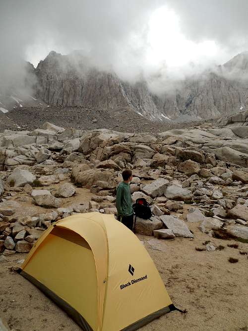
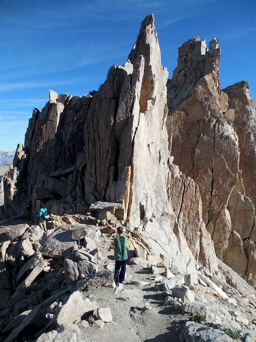
July 2-3: Wotans Throne/Mount Whitney/Mount Muir/Trail Crest Tower (California)
July 2
The original plan was for Kessler and I to climb Mount Whitney in one day, but the permit office in Lone Pine had three overnight permits, so my dad wanted to come.
We set off up the trail fairly early in the morning and enjoyed the scenery up to Trail Camp. At Trail Camp we were hit by a storm right after the tent was set up.
The weather was quite bad and other people climbing the peak were turning around. We were glad that we were attempting the peak the next day.
Kessler and I decided to check out Wotans Throne when the weather cleared in the evening. We climbed up the northernmost gully on the west side, reaching a chockstone not far from the summit. It was a nasty route and I didn’t want to climb the chockstone since I was afraid that we would pull loose rock onto us. We then checked out the gully to the south, but eventually the exposure became too great considering the loose rock (either route might make a good early season snow climb). We the bench around to the south side and explored along the South Chimney Route (we had no guidebook or beta since it was an unplanned ascent), but it too was pretty exposed considering we didn’t have any climbing gear or helmets. Thus, we returned unsuccessful since we ran out of time. We should have gone around to the north side which is much easier.
We also discovered that the marmots at Trail Camp are relentless and luckily bear canisters keep them out our your food.
July 3
In the morning, Kessler, my dad, and I set off to climb Mount Whitney. The weather was clear, unlike the day before. My dad (71 years old) lagged behind, so Kessler and I spent quite a bit of time on the summit waiting for him. He eventually caught up though.
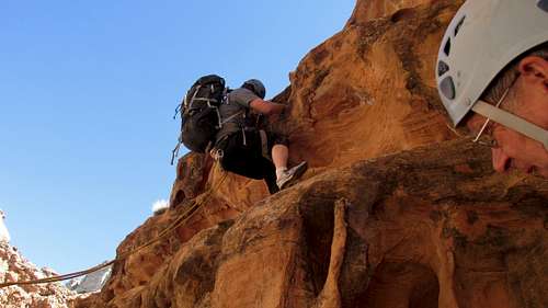
On the descent, Kessler and I took off ahead so that we could climb Mount Muir. Mount Muir was rated class 3 and although I knew that class 3 was generally harder in California than in Colorado, we underestimated Mount Muir. It was harder than I thought it would be. It was quite exposed as well. Since we weren't planning on climbing Muir until we happened to get the overnight permit, I hadn't brought any good climbing shoes and we just had old running shoes. We also didn't have any beta and didn't bring helmets. We probed two different routes before climbing one in the center of the summit block. It wasn't too bad until we had to do a slab traverse to the left with our low-traction shoes (sticky shoes would make this a piece of cake). We got up to the rappel anchor at the overhanging rock, but with our old running shoes we didn't want to stand on the summit. It was fun, but I wish we had brought better shoes (and a helmet).
Still ready for more action, we descended Muir and climbed what our map labeled as Trail Crest Tower. Either the map was wrong or there is a non technical route up the tower, because we didn't do any technical climbing. It was still a great viewpoint.
After climbing the tower, we descended and caught up with my dad on the switchbacks above Trail Camp. We packed up camp and headed down the mountain. One sore point is that a lot of people seem to leave their poop bags at Trail Camp. I took two garbage bags and put the extra poop bags in them and tied the garbage bags to the outside of Kessler's pack. We don't like packing out other's human waste, but it needed to be done. People who leave the bags are scum and shouldn't be allowed on the mountain.
The rest of the descent was routine, but at the end, Kessler and I went ahead of my dad in order to get drinks and ice cream from the store. It was a good climb, but the only sore point was the extra waste bags.
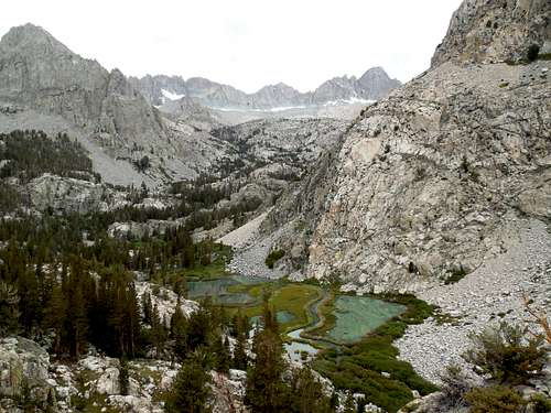
July 1: South Fork Big Pine (California)
My dad and I hiked up to Willow Lake. Since we had to pick up our permit for Mount Whitney that afternoon, we didn’t continue on to Brainerd Lake. It was a really scenic hike and the difficulty of the hike was exaggerated. The stream crossing was a bit challenging, but the trail wasn’t as steep as its reputation warrants. The scenery along the hike was really spectacular.
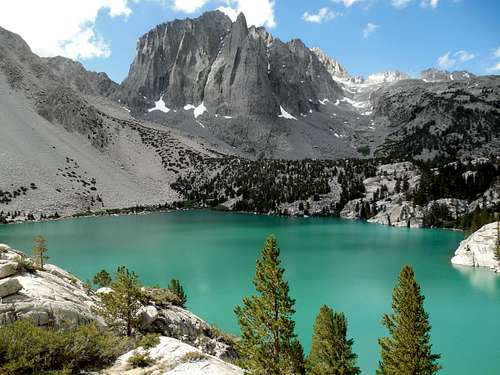
June 30: North Fork Big Pine (California)
Kim, Kessler, Shaylee, my dad, and I hiked along North Pine to the Big Pine Lakes. We took the trail past both waterfalls and to First Lake, Second Lake, Third Lake, Fifth Lake, Fourth Lake, and to Six and Seventh Lake before returning via Black Lake. It was a long 17+ mile day, but the scenery was spectacular. On the return trip, we got nailed by a big rainstorm which was quite long and cold. There was a bit of hail as well.
June 29: Logging Flat (California)
After driving from Tonopah, and going shopping in Bishop, my dad, Kim, Kessler, Shaylee, and I hiked up Big Pine Creek, past the first waterfall and then along the trail to Logging Flat. WE were out of time, so didn’t go farther than the flat.
June 28: Wheeler Peak/Bald Mountain (Nevada)
Kessler wasn’t feeling well, so he didn’t make it very far up the trail. Kim, Shaylee, my dad, and I climbed Wheeler Peak on a very sunny and warm day. It was a beautiful climb and we spent quite a bit of time on time,
On the way down, I also did a side trip and climbed Bald Mountain. The rest of the group went straight to the campsite. Climbing Bald Mountain with Wheeler Peak made a good all day trip.
After climbing the peaks, we took down camp and drove to Tonopah Nevada. Unfortunately, my dad ran out of gas along the way.
June 27: Wheeler Glacier (Nevada)
After spending the night in Delta to visit my 97 year old grandmother, we left for Great Basin National Park. I made a reservation for the 9 am tour, but forgot about the time change, so we were an hour early! Participants were my dad, Kim, Kessler, Shaylee, and I.
After visiting the cave, we drove up to the Wheeler Peak campground in order to reserve a campsite. We got the last one in the campground.
After setting up camp, we hiked the Wheeler Glacier and Bristlecone Trail. Kim wasn’t feeling well, so she didn’t hike very far.
The headwall of Wheeler Peak is very impressive and we went up to the glacier, passing many trees that were thousands of years old.
After visiting the glacier, we hiked back down to the forest and did the Alpine Lakes Loop Trail, visiting Stella and Teresa Lakes. Luckily there was a really nice spring to drink from at Teresa Lake.
We still weren’t done, so we also hiked the Sky Islands Forest Trail. We did a total of 7.6 miles this day.
June 20-21: Buffalo Ridge/Davis Peak (Colorado)
We were supposed to go to a wedding this weekend, but Kim and Kessler were sick. Instead, I took Shaylee to the Mount Zirkel Wilderness.
June 20
Shaylee and I started up Beaver Creek in the early afternoon. The trail was in pretty good condition, but there were several areas of deadfall to climb over. The upper part of the trail was quite muddy as well and the mosquitoes were thick.
Once we reached the saddle near Stump Park, we dropped our overnight gear and headed for Buffalo Ridge. The ascent took much longer than expected and it was a constant battle between soft snow, swamp, water, deadfall, mosquitoes, and mud. There was a bit of easy or dry ground. There was also a trick stream crossing, but we were already soaked by then anyway.
Once we reached the ridge along the trail (we couldn't find most of the trail), it was a more pleasant climb along the east ridge to the summit. Once we were finally(!) on the summit of Buffalo Ridge, we found and signed the summit log. There were four other signatures in the 21 years since the register was placed.
Because of the nightmarish ascent route, we decided to descend a different way. We followed the ridge west and then south to the top of Point 10,891. From there, we followed the ridge southeast and back to near Stump Park. Most of the route wasn't to bad, but the end of the route was the same nightmare we went through earlier. We did see at least a few hundred elk though. We did our best to keep a low profile and not to disturb them. They were all over the place! We were glad to make it back to camp where we cooked dinner and set up camp before retiring early for the night. The elk sure were noisy at night.
June 21
Shaylee and I woke up really early hoping that the snow would be hard so we could climb Davis Peak. Unfortunately it didn't get that cold at night and the snow was soft. We were in the snow most of the time, but we had to wade through much water and wet ground as well. There was also a lot of deadfall and the mosquitoes were just as bad as the day previous. Shaylee was a real trooper, but I swore that I'd never visit this place again at the same time of year.
We slowly made through the obstacles before losing the trail in the thick deadfall and snow. Instead of continuing to waste time looking for the trail, we postholed straight up the slope, which was agonizingly slow even though we were trying to move quickly. Once we reached the ridge, the snow was finally hard. We descended into a wet valley before wading across the creek to the snowfield on the other side. We were finally near Davis Peak and we ascended the snowfield almost to the summit. The snow was a mix of hard and soft snow.Once we were near the top, we could scramble up the boulders and to the summit. It was windy much of the way up, but this was a blessing since it blew the mosquitoes away! The views were really great, but we didn't find a summit register. There were a lot of snow clad and jagged peaks visible, but the long distance views were obscured by haze (forest fires?). We didn't stay too long on top since we were worried about the snow getting soft.
We descended the mountain and were lucky enough to find part of the trail to be fairly dry (we missed this part of the trail on the ascent). The descent wasn't too bad, but was still challenging. Again, we say many elk. One was right in the trail.
After arriving at camp, we packed up and headed down the mountain and then for home.
June 14: Willow Creek Trail/City Mountain (Colorado)
In the morning, Kim, Kessler, and I hiked the Willow Creek Trail near Steamboat Lake. We saw and owl and some deer. After that we drove to the Nipple Peak Trailhead in order to climb City Mountain. We followed the Nipple Peak Trail until we left the trail and climbed to the saddle southwest of City Mountain. WE then headed through the deadfall and to the steep scree slopes before climbing to the base of the summit block. We were surprised by the technical section blocking access to the true summit. We traverse the north side of the summit cliffs until we were east of the summit. It was then a class 5.0 exposed climb along a knife edge to the summit. We returned the same way down the summit block before descending the south face.
The peak was more difficult than expected and took longer than expected, but it was a good climb.
June 13: Fish Creek Falls (Colorado)
Kim, Kessler, Shaylee, and I hiked to Fish Creek Falls and Upper Fish Creek Falls in the afternoon and evening. Surprisingly, there was no snow to walk through. It was a great hike on a beautiful day and the falls were really roaring. After the hike, we drove to Steamboat Lake to camp.
June 7: Cedar Mountain (Colorado)
I took a hike up Cedar Mountain, completing the long loop.
May 31: Avalanche Gulch (Colorado)
In the morning, Kessler and I had no desire to put on our wet boots, so we just hiked up the Avalanche Gulch section of the Colorado Trail to the top of the switchbacks and to where the trail begins to parallel the creek.
May 30: Mount Yale (Colorado)
The night before. Kessler and I drove down to a campsite to climb Mount Yale with some 14ers.com members. Since I had already done the east ridge, we opted for the standard route.
Since we arrived late the night before, Kessler didn't want to get up at four, so we didn't hit the trailhead until almost 6 am. We hurried up the mountain and finally caught some of the other group near the summit ridge. Some were on the summit. The snow conditions were really nice on the climb to the summit and we we took a nice break on top. It was a beautiful climb and the last part was a bit rugged.
After climbing the peak, we headed back down and did some really nice glissades. Kessler and I glissaded all the way down to and directly to Delaney Creek, but that was a big mistake as the snow got extremely soft even with snowshoes and going down Delaney Creek was extremely tedious. We had to wade the creek as well. After much trial, we finally made it to the trail which we followed back to the trailhead. There was a bit of postholing until we were below 10,500 feet or so.
To sum it up, the climb up was great, the upper third of the descent was really great, the middle third of the descent was miserable, and the last third of the descent was OK.
May 23-25: Grand Gulch (Utah)
May 23
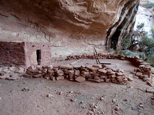
Originally, we had planned on doing some narrow canyons in Escalante, but the weather forecast called for rain. We couldn’t do any narrow canyons, but I suggested that we hike another section of Grand Gulch since it would be safe during rains. I hadn’t hiked the section of Grand Gulch between Bullet Canyon and Government Trail, but I wanted to. The recent rains should mean that there would be some wildflowers out, and water sources should be plentiful. There are many ruins that are 800-2000 years old (some of the pictographs are even much older than this) and it is an interesting and beautiful place.
Shaylee, Kessler, and I met my dad, Matt, and Dani at the Kane Gulch Ranger Station in the morning. We obtained our permit and Matt and I did the car shuttle to the head of the Government Trail. It rained lightly at times.
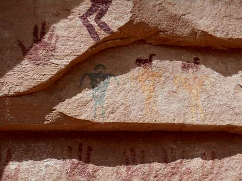
We all headed down Bullet Canyon. After not too long, it began to rain heavily and water spilled off the scrambling sections. I noticed a big pictograph high on the cliffs above the gulch. I doubt many people see it. There were also several desert wildflowers about, which were a gift from the recent rains.
This time we missed the rim top ruin and continued down to Perfect Kiva Ruin to eat lunch while seeking shelter from the pouring rain. We had a long and leisurely lunch at Perfect Kiva. Perfect Kiva is one of the few ruins where it is OK to enter, so we descended into its dark depths via a wooden ladder.
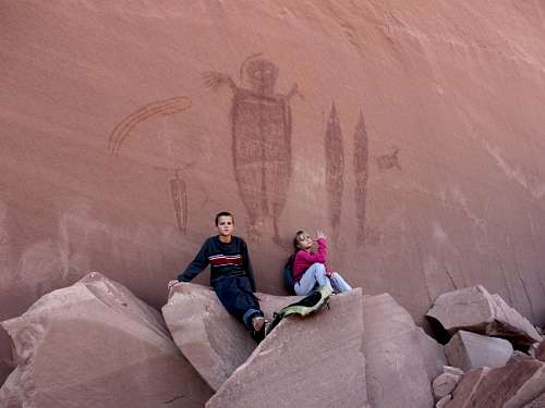
The rain tapered off a bit and we contoured around the rock benches to Jailhouse Ruin, which is almost camouflaged and blends into the wall nicely. The ruins were really neat and we stopped to take photographs. The ruins were named after a window with cross bars that makes the ruin have the appearance of an old jail cell. There is an upper level of the ruin as well, which is accessible only by some serious rock climbing. Above the upper ruin were some big white and green pictographs. There were also some interesting pictographs near the walls of the lower ruin as well.
Not that far from the ruin, I picked up what looked like a flat rock and it turned out to be a very nice looking potsherd. I put it back exactly where I found it.
We continued down canyon, but Kessler and I thought we forgot something at the ruins, so we ran back up canyon to search around while the others continued down canyon. We didn’t find our missing item, so returned to the packs. It was in our packs all along. We met the others at another ruin that they were checking out. From afar, we observed another ruin high on the cliff.
It rained on and off as we continued down Bullet Canyon, visiting one more ruin along the way, and observing another from afar. There was a good campsite at the junction of Bullet Canyon and Grand Gulch, where Kessler, my dad, my nephew, brother, and I had camped nine years previous, just after Kessler turned four. We wanted to continue down canyon to Green House Canyon, so we pushed on down Grand Gulch. This section of Grand Gulch isn’t hiked as often as the other sections and the going was rougher and slower. It was still raining and we had to wade down canyon and through the tall and wet grass, which soaked us. I noticed a pictograph panel of hand prints and “upside down rainbows” and I climbed up to it. The others didn’t want to make the climb, but I took photographs.
We continued battling our way down to Green House Canyon where we made camp. Luckily, there was a nice water source near the camp. There was also a ruin above camp which we climbed up to and explored the area.
It was a pretty long day, but I still walked up Green House Canyon to see if there was more water available around the ruin. Incidentally, there was also a slightly murky pool just below camp that was fine for cooking.
It was a wet day and it had its challenges (mostly due to the heavy rains), but it was a good day.
After setting up camp, we cooked dinner and rested for the night.
May 24
It had rained throughout hard during much of the night, but the morning was just partly cloudy. First, we hiked up Green House Canyon to see the Green House Ruin, one of the most interesting of the trip. The ruin has been partially pained green and is in very good condition.
Getting to the ruin involves climbing up some rock slabs to a ledge a following a very exposed ledge over the ruin. Right at the most exposed part you duck under a wall before reaching the ruin. My dad didn’t cross the final ledge, but the rest of us did. There were also some very preserved granaries on the ledges around the Green House as well and one of them has an intact door. After returning to Grand Gulch, we packed up camp and headed down canyon. It wasn’t raining more than a sprinkle at times, but we still got completely soaked wading through the tall and wet grasses.
The next point of interest was the two story ruin just before we reached Step Canyon. It is also very interesting a well preserved. We spent some time checking out the ruins on the ledge.
Just up Step Canyon is a really nice petroglyph panel. It is unique since it has green paintings, which are rather rare. There were also yellow and red paintings. Most paintings are only red or black. There were many ancient hand prints as well.
After Step Canyon, we hiked down Grand Gulch to Dripping Canyon. There are some good pictograph panels in Dripping Canyon as well and some look like birds. There were also some interesting white painted handprints. Some of the Barrier Style Pictographs were rubbed partially off. Barrier Style Pictographs are much older than other sites in Grand Gulch and are thought to be 3000-8000 years old. It is also thought that the Anasazi themselves may have rubbed off some of the old pictographs.
Not far down Grand Gulch was Cow Tank Canyon, which has yet another interesting pictograph panel. After exploring Cow Tank, we continued down canyon. Around a bend in Grand Gulch, there was a panel under an overhang high above the floor of the gulch. Many people walk right under it without seeing it. Below Cow Tank Canyon, the vegetation in Grand Gulch thins out and walking becomes easier.
Around lunch, it began to rain hard again, but luckily the rains were short lived.
Not far down canyon was a ruin known as Long House. It looked great from afar, but was well guarded by a huge cactus field. It is known that the Anasazi use to cultivate cactus for their fruits, but over the millennia, this one had grown to monster proportions. I think all of us got pricked at least a few times. Alas, we didn’t find Long House to be quite as interesting as some of the other ruins and it wasn’t as well preserved.
The next major stop is Big Man Pictograph, but we saw one more ruin along the way. To find Big Man, you are supposed to look for an arch and then reference to down canyon, but we never saw the arch before seeing Big Man. I was looking at the walls for an arch, but saw the pictograph itself.
We climbed the steep route up to the Pictograph, but my dad was too tired to make the climb, so he observed the pictographs from below. This was definitely the best pictograph panel of the hike.
After finding Big Man, we continued down canyon, hoping to reach Pollys Spring for camp. The weather was good now and we didn’t have any rain. We did observe one ruin along the way, but we didn’t climb up to it. There were also some interesting rock formations and a small arch.
Once we were at the mouth of Pollys Canyon, we found a great campsite. We set up camp and stocked up on water. I noticed a big arch not that far up Pollys Canyon and when I told the others about it, they hiked up to it was well.
Kessler and I also hiked down Grand Gulch to locate the Government Trail. We thought we’d look for it now rather than waiting until the morning when we had heavy packs on. There were a lot of pretty pools in the slickrock of this section of the canyon and many were filled with tadpoles.
May 25
At night, it rained a few drops, but nothing more and the morning was dry and somewhat overcast. It was going to be an easy four mile day. We hiked down Grand Gulch and made our way up the Government Trail. We got to the top faster than expected and it was a pretty walk. The weather was perfect for the hike and we were glad that there was cloud cover.
Although we were now out of the canyon, the walk back to the trailhead was still pretty and had many distant views. We could see as far as Navajo Mountain and the Henry Mountains. The Bears Ears and other cliffs in the distance were also impressive.
The hike back was uneventful, but we did pass some nice flowers, including cactus flowers. Once we reached vehicle near the trailhead, we packed all six of us into my Outback and did the car shuttle.
It was a great trip! On the way back we also stopped at the Dinosaur Museum in Blanding before heading home.
May 22: Trail Through Time (Colorado)
On our way to Blanding, Shaylee, Kessler, and I stopped to hike the Trail Through Time, near the Utah/Colorado border. The weather was threatening, but it never did rain. The trail is quite interesting and passes many exposed dinosaur bones and other interesting features.
May 20: Cedar Mountain (Colorado)
In the evening, Kessler and I climbed Cedar Mountain with the boy scouts. We saw several deer.
May 15: Cedar Mountain (Colorado)
Kim and I climbed Cedar Mountain with three cub scouts and one of their fathers. It rained most of the day, but we had good luck with the weather on the mountain. We saw a few deep and a rabbit.
May 12: Sand Rocks (Colorado)
I took an evening walk over the Sand Rocks.
May 9: Three Canyon (Utah)
Originally, my son and I were going to do a climb of Horseshoe Mountain in Colorado, but a big snowstorm was forecasted.
We decided to go to Utah, but the weather forecast was iffy for slot canyons as well. After some brainstorming we decided on Three Canyon, south of Green River. It only had one rappel at the top and then a 5.6 exit at the end, with lots of pretty canyon between that would be fairly low risk for flash floods.
Unfortunately, my son got sick last minute, so I would have to go solo (my wife had to work and my daughter wanted to sit this one out). I prefer not doing technical canyons solo, but it appears that I was out of luck and besides, I left a detailed plan with my wife. I could only go for one night since it was mother’s day on Sunday as well.
I drove to Green River in the rain before checking in the Robbers Roost Motel. Staying there was a good move since it did rain hard at night.
I was surprised when I woke up in the morning to sunny skies. I drove to the head of Sneak Canyon, where the exit is and hid my bike. Since I was alone, I hiked and scrambled to the top of the crux exit route of the canyon and left behind an aider and a rope. I didn’t want to free solo the route alone.
After placing the aider, I hiked back to the vehicle and drove to the head of Three Canyon. I hiked down through some narrow sections to the head of the rappel. The 100 foot rappel is the only technical obstacle in the canyon until the exit.
Once I completed the rappel, I left the rope behind and hiked down the canyon. Three Canyon is usually ignored by hikers and canyoneers. The entry and exit routes are hard enough to keep out hikers, and since the canyon has few technical obstacles and is mostly a hike, and since there isn’t a real slot, not many technical canyoneers do the canyon either. What the canyon is however, is probably the most beautiful of all the side canyons draining into Labyrinth Canyon of the Green River. The high walls, oasis in the desert, the small cascades, deep narrows, and crystal clear running water make the trip very pretty.
I hiked down the canyon, passing one obstacle which was a 10’ downclimb. After that it was smooth sailing (with one more minor obstacle at a big pool and small waterfall) through a very beautiful canyon . I reached the exit in Sneak Canyon faster than expected. I made the exposed 4th class scramble up to the “sneak route” 5.6 pitch. With the aider behind, it was pretty easy.
Once out of the canyon, I retrieved my bike and rode the three and a half miles of dirt road back to the trailhead.
Since the canyon took less time than expected, I still had a little time on my hands. I visited the Chaffin Geyser on the way back. Luckily it was having a small eruption right when I got there. I watched the eruptions for a while before heading for home.
May 6: Sand Rocks (Colorado)
Kessler and I took an evening hike over the Sand Rocks.
May 3: Cedar Mountain (Colorado)
Alone, I hiked the short loop over Cedar Mountain. I saw several rabbits, but no deer this time.
May 2: Cross Mountain (Colorado)
Kim had to work and the kids weren't interested, so alone I climbed Cross Mountain. I started all the way at the northern end and traversed all of the intermediate summits until reaching the highest one. It took longer than expected. I hadn't been to the summit since 2009.
The weather was threatening at times, but it only rained briefly and with distant thunder. Along the way, there were many elk tracks, but I believe the elk have headed to higher ground. I did see several rabbits and one horny toad. Surprisingly there was an old horse skull near the summit. There are many wild horses in the vicinity, but I've never seen the on the summit ridge.
For the route down, I descended the steep east face and contoured around the mountain. There were several cliff bands to skirt, but eventually I made my way to the base of the mountain which I followed north and back to the trailhead. I saw several antelope along the way. On the drive back home, I got to see the annual wild horse roundup, were many wild horses are rounded up by the BLM.
April 30: Sand Rocks (Colorado)
I took an evening hike over the Sand Rocks, east to west and back.
April 29: Cedar Mountain (Colorado)
Alone, I hiked Cedar Mountain in the evening, completing the long loop. I saw several deer and some rabbits. There were also some horse riders up there; usually I don't see any other people on weekdays.
April 24-25: Peak 10 (Colorado)
April 24
Shaylee, Kessler, Kimberly, and I snowshoed to Francies Cabin in the late evening; not starting until dark. The half moon was surprisingly light, but we still used headlamps. We made it in just over an hour.
April 25
The original plan was to have Kessler climb Peak 10 with me, but he had hit his head at school the day before and had a big bump, so decided not to risk it.
I climbed the east ridge alone and made a fast glissade off the southeast face. It was a good glissade, but there were a few cliff bands to avoid. From the summit, I could see a storm approaching, so I didn't want to stick around. I got back to the hut just as the snowstorm hit. We packed up and snowshoes through the heavy snow falling, but it cleared up as we descended the mountain.
April 21: Pigeon Island (Saint Lucia)
Today we did the Sea Trek, which is where you use helmets to walk on the ocean bottom. It was quite interesting and we saw jellyfish, urchins, colorful fish, lobsters, etc.
After the Sea Trek, we did some short walks on Pigeon Island before heading back to the hotel. It was time to catch the shuttle to the airport and end our trip in St. Lucia.
April 21: Northeast Coast (Saint Lucia)
Today Kim and I decided to take the hike along the Northwest Coast of St Lucia, which although very scenic, seems to be a forgotten corner of the island. There didn't seem to be any buses headed out to Cas en Bas, so we took a taxi (it wasn't that far from Rodney Bay where we were staying).
We were told heading north was more interesting, so we headed towards the north point of the island. We hiked around several points and sea cliffs and tried to stay as close to the coast as we could, though we made detours to some of the highest hills and bluffs in order to see the views. There were many deserted beaches along the way. It was hot, but I could take a dip in the ocean to cool off. We saw much sea life, including a good sized crab. The coast is very rugged and has an almost desert like appearance with some good sized cactus.
We eventually reached a big sea cliff and started hiking inland to bypass it. We eventually reached a section of bushwhacking. Given the heat and time of day, we decided to head back at this point. We did meet one couple hiking to Donkey Beach, the only people we met on the hike.
When we got back to Cas en Bas, we ate a late lunch/early dinner at a laid back place on the beach. We decided to walk back to Rodney Bay, but the heat was stifling. Luckily a bus passed, which was a bit of the normal route because the driver was taking someone home. We took the bus back to Rodney Bay. We ate some jerk chicken on the beach, spending the rest of the day there. We got to watch our last sunset on St. Lucia.
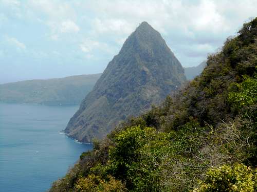
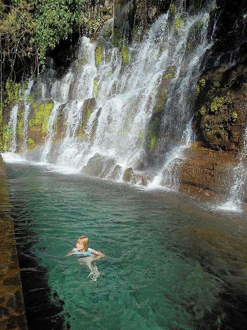
April 20: Soufrière Volcano (Saint Lucia)
Today we visited many places along the west coast via catamaran. It was really spectacular to see the two Pitons (one of which we climbed on April 17) from the ocean. We stopped at a waterfall where I took a quick swim before heading to the steaming, bubbling, and boiling, Soufrière Volcano. We took the nice hot mud bath (which makes your skin very soft) before doing the short (but very interesting) hikes around the volcano. It is a bit touristy, but very interesting.
After the volcano, we did the walks through the plantation and botanical gardens. They were quite interesting and the food was good. They showed us how chocolate is made as well. We did some snorkeling in one of the bays afterward and saw lots of sea life.
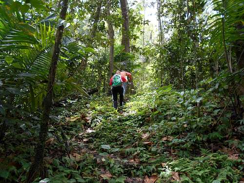
April 19: Jacquot Trail (Saint Lucia)
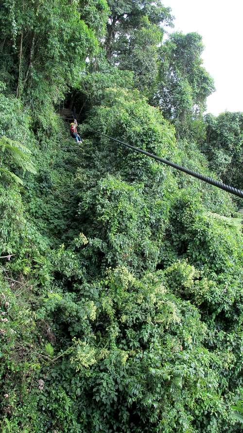
Today we did the rainforest tram, zipline, and Jacquot Trail combo. We rode the tram and did the ziplines before hiking the trail. The trail is interesting (and easier than advertised) and we got to see several St Lucian Parrots (jacquots) Kennedy and Jeffery, the guides (required), we quite entertaining. We got to see a lot of different kinds of birds and trees.
It was a good, and relaxed day.
April 18: Signal Peak/Pigeon Island (Saint Lucia)
We slept in and then took a boat shuttle across Rodney Bay to Pigeon Island in order to do some hikes there.
Wikipedia says the following about the history of the island:
The Arawak people, the original inhabitants of Pigeon island, were driven out by the Caribs around 1000 A.D. The Caribs lived in caves along the shore of the island, and hunted for fish, shellfish, small animals and birds. They also foraged for plant food. In the 16th century, a French pirate, François le Clerc, used Pigeon Island as his base. He forged an agreement with the Caribs, so that they would not attack his ship.
In 1778, Admiral George Rodney took over Pigeon island, expelled the natives, and built a fort on the smaller of the two peaks. This fort is known as Fort Rodney. To establish clear sightlines, Rodney ordered all trees on Pigeon Island to be cut down. From the higher peak, Signal Hill, Rodney was able to observe the French naval base on Martinique.
Over the next several years, the British built several other structures on Pigeon Island, including two barracks, a mess hall, and a lime kiln.
About 3/4s of the way up the island, visitors will find the ridge battery.
This sign from the Saint Lucia National Trust describes the 32 pound gun once sited here.
In 1782, Admiral Rodney sailed from Pigeon Island to confront the French fleet, which he defeated in the Battle of Saints.
In 1824, a barracks which had been destroyed by a hurricane in 1817 was rebuilt.
The ruins of many of the historical structures are still there, making it an interesting place. We hiked to the lookout fort (Fort Rodney) on the west point of the island before heading east and climbing Signal Peak, which has a little scrambling, and the highest point of the island. The views were great, but clouds obscured the view of Martinique, the French island country to the north. We took a long walk along the beaches to the south as well.
It was a great and interesting trip and had some good hikes. It was hot out, but the trails were mostly easy. Since the hikes were short, we actually got to see the beaches in the daylight!
April 17: Gros Piton (Saint Lucia)
Today we climbed Gros Piton, one of the two iconic and most famous mountains of the island (the other is the Petit Piton). We went with Real St Lucia Tours since they gave us a good price (a guide is required for the hike) and it wouldn't have been any less expensive to drive ourselves. The drive to the trailhead was very scenic too. The Pitons definitely fit the definition of rising straight out of the ocean!
The climb was excellent, and although steep, it wasn't as difficult as some of the other rain forest mountains that we have done. We began to worry a big when every single people we met on the trail (we got a later start than most) before the half way point said that they didn't reach the summit and that it was extremely difficult.
There were some sections where scrambling over logs and over rocks was required, but the trail was actually really well constructed and there were even handrails in places. It was steep, but wasn't overly slippery. Past the half way point, we started to meet people that had actually made the summit. I guess the reason a lot of people don't make it is because they are "regular tourist" rather than climbers.
We saw many birds and lizards along the way and even a hermit crab high on the peak. We also heard the brush rustling a bit, but never did see what animal it was. We also saw a gigantic (!) wasp and some humming birds.
The views were excellent and you could look straight down on the ocean for much of the distance. Even with three rest along the way, we reached the summit in just over two hours at a fairly leisurely pace. It was a little warm at times, but the climb was very enjoyable. We took a long lunch and break on the summit before heading back down. It did rain a bit, but the trail didn't get that slippery. It took about 4 and a half hours round trip, including rest breaks.
We still had time, so we visited the Piton Waterfall, which is only a short "hike" (actually more of a stroll). There were some warm pools, but the waterfall itself had water that was a perfect temperature. It was very pleasant and a great way to end the climb.
We actually arrived in Rodney Bay very late. A semi had overturned on the main road, so we were delayed for hours. We took a walk on the beach that evening, but we had yet to see the beach in the daylight hours!
April 16: Mount La Combe (Saint Lucia)
The plan today was to climb Mount La Combe, using the Barr de L'Isle. Mount La Combe is near the center of the island of St. Lucia and is in the rainforest. In order to get an early start, we thought it would be best to find a taxi to the trailhead and then take the bus back.
Since Mount La Combe is in a Forest Reserve you have to pay an entrance fee. Though a guide is optional, the entrance fee includes a guide as well, so we figured we might as well take one. We took the trail south and hiked to several viewpoints and along some intermediate summits. We heard several St Lucian parrots (jacquots), but only got fleeting glimpses. There were many interesting trees along the trail. The area is said to be inhabited by ghost and spirits.
Unfortunately, hurricane Tomas (October 2010) destroyed the last part of the trail to the summit, causing a huge landslide that left an almost vertical scarp. At this time, the summit portion of the trail is closed, so we didn't reach the summit and we retreated down the mountain. We did see a mongoose on the descent.
We retreated down the mountain and caught a ride back to Rodney Bay. We had a romantic candlelight dinner on the beach, but I guess that's another story.
April 10-11: Shrine Mountain (Colorado)
April 10
Last minute, we bought someone's spot in Chuck's Cabin near Shrine Mountain. Kessler and I hiked up to Chucks Cabin in the dark before retiring. It was a pleasant walk by headlamp.
April 11
Kessler and I decided to climb the Wingle Ridge and Shrine Mountain since the steep slopes and cornices on the east side of the peaks are a good place to practice snow climbing.
We left fairly early in the morning and the snow was rock hard. We climbed Shrine Mountain with no difficulty and glissaded off the east face, which wasn't that easy with hard snow. Unfortunately, I ripped my new down sweater on the hard snow. We decided to head back and forgo climbing on the Wingle Ridge.
April 3-5: Chimney Canyon (Utah)
April 3
After a long and dusty ride along sometimes rough roads Kessler, Shaylee, my dad, and I finally arrived at the trailhead around 10 AM.
We found the old trail down into the canyon and continued downcanyon without a trail. The going wasn’t too difficult, though we had several minor obstacles and some slot sections. We also made sure that we explored every side canyon that appeared to be worthwhile. There were some nice side slot canyons that were fun to explore and that had some technical obstacles. Eventually we reached the first real obstacle of the day, a 50 foot rappel, with an old bolt station (and some ancient runners which I replaced). Luckily the deep pothole below the rappel was dry and the rappel was a pretty easy one and not too awkward. My dad isn’t as used to rappelling so he was more nervous. Since we couldn’t see how much spare rope was at the bottom and since I wasn’t sure how deep the pothole was, I lowered my son down in in order to check things out. The climb out of the pothole was doable, so everyone else followed. Not long after the pothole, there was a big chockstone obstacle to negotiate.
After the obstacle, we continued down canyon. The canyon was indeed beautiful and interesting and there were more narrows and slots. There were also some fantastic formations in the rock walls. We eventually reached the next obstacle, which turned out to be the crux of the trip. It was a sheer 66 foot/20 meter dryfall dropping into a pool.
Getting to the descent wall bypass on the south side involved traversing some narrow and exposed ledges and loose rock. Kessler and I pushed on ahead to scout out the route. It wasn’t pretty. I found the wall descent route, but I had underestimated the difficulty. The descent wall was reported to be 5.3 in difficulty, but it was also incredibly exposed and falling off it would be fatal. There wasn’t much in the way of possible rappel anchors, so I returned back to the others at the dryfall and decided to look for an alternative route. I surmised that we could rappel onto a ledge on the north side of the dryfall. There was a tree available for an anchor, but it was an awkward and sharply overhanging rappel.
I returned to the fall itself and found out that we had just enough rope to reach the bottom if I constructed a deadman anchor. My dad was scared of rappelling off a deadman, and said that he wanted to try the bypass. I was afraid that it would be too difficult and scary for him, but we decided that we would try it anyway. We negotiated the loose and exposed ledges over to the bypass wall. It sure looked scary to downclimb. I noticed that there was a small bush and an old dead log just up-canyon from the bypass. We could place the dead log against the bush and rappel off that. The rappel wasn’t that bad and I sent my son down first to check things out. After the rappel, it was a rough, but fairly easy scramble down to the canyon floor. We all breathed easy as we knew that it would be our last major obstacle.
The canyon widened out slowly, but it was still beautiful, had high walls and some running water, and had some really nice rock formations.
We made our way to the North Fork, which we wanted to explore. We explored all the hidden grottos and side drainages of the North Fork and it sure was beautiful. Unfortunately, I left my cameral back in the pack at the junction of the North Fork and main canyon.
The North Fork drainages were spectacular and are reminiscent of the canyons in the Escalante country, with high walls, narrow canyons, and running water. We took one drink at a spring in a hidden grotto. We explored the two main branches of the North Fork as well as some very pretty hidden grottos in the side drainages. It was getting late, so after thoroughly exploring the area, it was time to return to the packs in the main fork were we continued down canyon. There was one small waterfall that made a fun obstacle.
We camped at a spring and old mining camp and at the junction of the South Fork and the Main Fork. It was a long, but very rewarding day and we didn’t have much daylight left by the time we settled into camp. At camp, there was a pet dinosaur that Shaylee fed.
April 4
The next day we decided to explore the south fork of the canyon and hike the old mining track, known as the Pasture Track. We bypassed the small waterfall near the mouth of the South Fork. We explored the South Fork first, which had two main branches and several smaller ones. The right fork looked more promising, so we explored that first. At a huge rockjam and fall, progress appeared to be blocked. We found a bypass on the left side that involved climbing up a small cliff, but my dad decided not to make the climb. The kids and I climbed the wall and explored the rest of the canyon. Eventually we reached a towering headwall and the biggest alcove that I had ever seen. There was definitely no way out of this drainage.
We then headed back and explored the left branch. It got better as we climbed up canyon and running water began to appear. The canyon was very scenic and had a massive arch and a pretty waterfall with travertine stalactites. Eventually, after several obstacles, we reached an obstacle which couldn’t be bypassed without some rock climbing gear. I wondered that if we could bypass this technical pitch, if there was a route to the rim. We returned back to camp after our explorations.
Next on the list was the old Pasture Track, used by miners in the 1940’s and early 1950’s. We hiked down canyon and located the track and followed it north, passing an old Ford Car along the way (it must have been a really long way to the nearest gas station from here!). There were some spectacular volcanic dikes sticking out of the canyon wall and some petrified wood as well.
Unfortunately, some dirt bikers had illegally found a way into the canyon and track and had torn up the place a bit. This was really disappointing in this deep in the Wilderness Study Area.
We had hoped to reach an overlook of The Chute of Muddy Creek and to look into its deep narrows, but we eventually ran out of time. We got a distant look at the narrows, but didn’t have time to route find through the cliff bands and to get a closer look. With fading daylight, we returned to camp. It was another great day.
April 5
Today we decided to use the old mining track past the Little Susan Mine and eventually to the Hidden Splendor Mine. The first order of business was to locate the old and faded mining track. We found it without too much trouble, though we lost it a few times enroute to the abandoned mine. We took a break at the Little Susan Mine and explored the old ruins. They were still in good condition, though some of the cabins had collapsed.
After exploring the mine area, it was just a walk along the benched and down a very scenic little canyon to Muddy Creek. The water was fairly cold, but it was clear and we had to wade it a few times before ascending the final rock bench to the vehicle. After reaching the vehicle, the only thing left to do was the long car shuttle.
March 31: Cedar Mountain (Colorado)
Kimberly, Kessler, and I climbed Cedar Mountain; completing the long loop.
March 28-29: Pearl Peak (Colorado)
March 28
Shaylee and I started out at the valley floor and climbed to the Jackal Hut, where we spent the night. We started at the South Camp Hale Trailhead, but unfortunately, the warm weather caused all the snow bridges to melt out and we had to wade the icy Eagle River. We shed our boots and barefooted across the river, since we didn't want soaking wet boots for two days. The rest of the snowshoe to the hut was routine, but there were some bare spots and the fact that it was very windy.
March 29
In the morning, we awoke to a skiff a fresh snow, but clear skies and 9F. We climbed Pearl Peak. The morning and the climb to the peak was pleasant and we enjoyed the nice views.
The afternoon was too warm though and made for postholing conditions in several places, even with snowshoes on. The end of the route was actually frustrating and tedious because of this.
It was still a good climb.
March 27: Cedar Mountain (Colorado)
Shaylee, Kessler, and I climbed Cedar Mountain; completing the long loop.
March 26: Cedar Mountain (Colorado)
Shaylee, Kimberly, and I climbed Cedar Mountain in the evening, completing the long loop. The snow was almost gone and there was a little mud. We saw several deer and a rabbit.
March 21: Dyer Mountain (Colorado)
Kessler (my 12 year old son), I, and six other climbers (including on 13 year old) met in the morning to climb Dyer Mountain from the Leadville side. Kessler and I had to stay up late the night before, so we left at 3:45 AM, but were delayed on the road, so didn't reach the trailhead until 7 AM.
There were four skiers and four snowshoers. We all made steady progress up Iowa Gulch and into the Iowa Amphitheater. Once the sun hit the slopes of the mountain, it was intense! We applied sunscreen several times throughout the day, but Kessler and I still got too much sun.
We climbed the southwest sloped up to the summit ridge, which was followed to the summit. The day was sunny and bright and the views were nice.
Four people brought skis and the other four glissaded down.
It was a great climb, but the road at the end of the descent seem to drag on forever, at least on snowshoes.
March 15: Mount Garfield (Colorado)
Kessler, Kimberly, Shaylee, and I climbed Mount Garfield. It was a little windy, but it was a very warm day, especially for March. We did the steep standard route to the summit.
The kids were usually ahead of us and we had them loaded down with all the stuff.
It was a good little climb and of note, it was Shaylee's 300th mountain.
March 14: Devils Kitchen/No Thoroughfare Canyon (Colorado)
Shaylee, Kimberly, and I hiked and explored around the Devils Kitchen before heading up No Thoroughfare Canyon in Colorado National Monument. We hiked to the second waterfall and were lucky that they were flowing.
At the first waterfall, a rockfall hit Kim in the leg and gave her a big bruise and scrape. Since the weather was good and there were no people above us, it was probably caused by an animal.
Other than that, it was a really great hike.
March 13: Riggs Hill (Colorado)
Shaylee, Kimberly, Kessler, and I did an evening hike around and over Riggs Hill near Grand Junction. We just missed the sunset.
March 8: Hell Roaring Canyon (Utah)
Shane, Stormy, Kessler, Shaylee and I head out to Hell Roaring Canyon today. We wanted to see the Yellow Comet Pictograph. Kessler, Shaylee, and I had already been there several times, but Shane and Stormy had not.
We did the crawl route into Hell Roaring. It was easy to find since I had already been there before. We then visited the pictograph and headed down Hell Roaring Canyon and up Dubinki Wash in order to climb the impressive cattle trail out of the canyon.
March 7: Fins and Things Slot/Mill Creek/Wall Street (Utah)
Shane Burrows and Stormy met Kessler, Shaylee, and I in Moab in order to do the Fins and Things Slot canyon. Kessler, Shaylee, and I had done it one month prior, but Shane hadn't done it and wanted it for his website (climb-utah.com).
We drove to the trailhead and hiked to the canyon, but I noticed that we forgot our helmets so I ran back to the car and got them. I caught up to the rest of the group before the first real downclimb.
The canyon went routine, with one wading pool, but it was a warm day. The rappel was short, but a little tricky.
After completing the slot, we headed down Mill Creek and visited two petroglyph panels and one pictograph panel along the way. Shane found a high route around the big swimming hole in Mill Creek, while the rest of us found a moki step route down the cliff.
In the afternoon we climbed on Wall Street. Kessler led all the routes up to 5.9.
March 5: Sand Rocks (Colorado)
I did an evening hike over the Sand Rocks. There was some fresh snow and it was cold and windy, but it was a nice hike under the full moon.
February 28: Cedar Mountain (Colorado)
Shaylee and I climbed cedar mountain, completing the long loop. There was a fair amount of snow in some places and dry ground in others, which made the decision of whether or not to wear snowshoes a difficult one.
We say many animal tracks in the snow, but only one deer.
February 25: Sand Rocks (Colorado)
I took an evening hike over the Sand Rocks.
February 20-21: North Twin Cone (Colorado)
February 20
Kessler, Shaylee, Kimberly, and I left to snowshoe up to the Broome Hut, which is between First and Second Creeks near Berthoud Pass. It was snowing hard and the roads were bad, but we felt lucky that we weren't driving in from the other side since I-70 was closed due to the storm and all traffic was being diverted over Berthoud Pass.
Despite the snowstorm, we made good progress up the mountain and it only took us just over 40 minutes to arrive at the hut. We got to the hut just as it was getting dark, so it was good timing.
February 21
In the morning, I was the only one who wanted to climb Twin Cones. The rest of the crew decided to stay behind. The weather temporarily cleared, providing some nice views, but with the new snow, I would have to break trail the whole way. I chose a route that would avoid any avalanche danger.
The weather was on and off snow and partial clearing and I made my way towards Twin Cones. I had climbed Twin Cones before, but I left the map in the hut and the visibility got worse as I approached the ridge. By the time I reached the ridge, there was almost no visibility, but I headed in the direction that I thought Twin Cones was. I turned out to be right and during a partial clearing could pick out the summit of North Twin Cone through the clouds.
The climb to the summit was pretty easy, except for the very last part which was a boulderfield which was a challenge with the new snow. After reaching the summit, I didn't spend much time since there wasn't that much of a view. It was snowing, but the winds were calm, which is a rarity at this elevation, especially in winter.
A loud boom startled me, but it was Winter Park shooting off avalanches. I could just pick out the summit of South Twin Cone, but I decided to head back down the mountain.
On my descent, I could see a skier that passed fairly close to me, but other than that, it was a quiet climb, but with many animal tracks in the fresh snow.
As I made my way down the mountain, it began to snow harder and when I arrived at the hut we packed up quickly and headed down the mountain. By the time we reached the trailhead, it had stopped snowing, but the snowplows had blocked us in from the highway. We eventually made it through the snowbank and headed for home.
February 16: Holeman Slot/Fort Bottom Butte (Utah)
Kessler and I explored the Holeman Slot Canyon in the morning. My dad elected not to descend since we took a harder route in to avoid wading in water. This time through the Holeman Slot, it was more technical than usual since there was more mud and water on the rocks. I had brought an aider and sling though, just in case, and this time we did use it (usually we don't use one while doing this canyon). We also did a lot of stemming in the slot to avoid potholes. We got to near the big pouroff in the canyon, but this time there was a big unavoidable pool and we turned back.
After the Holeman Slot, we drove to the Fort Bottom TH and hiked over to and climbed Fort Bottom Butte, which has an impressive Anasazi ruin on the summit. My dad opted out of the final pitch though. After enjoying the ruin, we climbed back down the butte and walked down to the Green River and to the Outlaw Cabin. The cabin was built in the late 1800's and might not be around much longer.
After eating lunch at the cabin we hiked back to the trailhead and then headed for home. Part of the drive along the White Rim 4x4 Trail wasn't pleasant since the weather was bad and the strong winds were blowing small rocks and pebbles off the cliff and onto the vehicle.
February 15: White Crack (Utah)
Our main goal was to explore the old White Crack Trail to the Mining Camp and an overlook of the Green River, but we did stop at some roadside viewpoints along the way.
After finding the White Crack Trail, we walked it through some very scenic and colorful country with some nice views. There were good views of the Maze, Needles, and the Abajo and LaSal Mountains out in the distance.
The trail is quite long though, so my dad turned back 4.5 miles in. Kessler and I walked an additional mile to an overlook of the Green River, which was very scenic.
We just missed the mining camp, but we wanted to get back in order to drive the Murphy Hogback in the daylight.
February 14: Goosenecks Overlook/Walking Rocks/Musselman Canyon/Mussleman Arch (Utah)
My dad, Kessler, and I camped at the Shafer Campsite on the White Rim 4x4 Road the night before. In the morning we drove to the Goosenecks and did the hike there.
We then drove to the Colorado River Overlook and walked out to the Walking Rocks, an impressive set of towers. We found a crack to climb down and followed a very rugged route down to the floor of Musselman Canyon. Once in the canyon bottom, we explored the canyon towards the Colorado River. We found cougar tracks in one place and reached an impressive waterfall and a big pool. We contoured the bench a while before eating lunch.
After lunch I explore the bench on the right all the way to the Colorado River and let the others know that I had also found a route through the cliffs and to the canyon floor not far from the river. We decided to head back to the rim though.
We hiked back up Mussleman Canyon and climbed up to just below Musselman Arch. It was very rugged. We then contoured around and found a technical crack that we could climb, but with a few exposed moves.
After the climb out and walk back to the vehicle, we did some short walks to viewpoints before driving to the Gooseberry Campsite.
February 8: Courthouse Wash (Utah)
First, Kessler, Shaylee, Kimberly, and I rode our bikes from the Bar M Ranch, down to Moab,a ways up the Colorado and then back to Courthouse Wash. We then hiked up Courthouse Wash to the little waterfalls seen in the photo below. It was a beautiful and very warm spring-like day.
February 7: Fins and Things Slot (Utah)
Kimberly, Kessler, Shaylee, and I met Dave and his 11 year old son Brandon in Moab in order to do the Fins and Things Slot since we had not done it yet. It was a little brushy and I regretted wearing shorts, but the canyon and slot was nice and had some fun downclimbing. We did one short rappel, but were able to downclimb everything else.
Once we were at the sunny mouth of Fins and Things Canyon, we explored up North Fork Mill Creek a ways before heading down canyon. North Fork Mill Creek is a beautiful canyon with lots of clear pools and waterfalls. The weather was so warm that we didn't even bother trying to keep our feet dry. There was one traverse around a huge pool which was a challenge. After that, the route was straight forward. Once we reached the confluence of the main and north forks (which has some really nice petroglyphs), we explored up Mill Creek for a while before heading back down to the shuttle car.
It was a beautiful sunny 70F degree day and we couldn't have asked for better weather.
January 31: Glenwood Caverns (Colorado)
Since the weather was bad, Kimberly, Kessler, Shaylee, and I went to Glenwood Caverns so we could do our hiking underground. We only did the normal tours (Fairy Cave and Kings Row), but it was still nice.
January 27: Sand Rocks (Colorado)
In the evening, I took a hike over the Sand Rocks east to west. There isn't as much snow as normal and there was even some mud. I saw several deer as well.
January 25: Jenny Lake (Wyoming)
Since there was some sunshine out, Kessler, Kim, Shaylee, and I returned to the Taggart Lake Trailhead to hike towards Jenny Lake. Since the mountains were socked in again, we didn't hike all the way to the lake.
We did get some views of the mountains on the drive out, but when we were close to the mountains, the cloud deck prevented any views.
January 24: Taggart Lake/Ridge (Wyoming)
Kim, Kessler, Shaylee, and I made a loop snowshoe trip of the Bradley Lake and Taggart Lake in the Tetons. We also took a side trip to the top of the ridge, but there were no views since the mountains were socked in.
Early on, there was some freezing drizzle and then some snow and wind. The trip was nice, but it was a little disappointing that we didn't get to see the big peaks.
One of the highlights of the trip was actually on the way to the trailhead. We saw a wolf.
January 16-17: Wingle Ridge (Colorado)
January 16
Kim, Kessler, Shaylee, and I set off for Walter's Cabin at Shrine Mountain. We started right as it got dark and we snowshoed by headlamp on a cloudy and starless night.
Some strong winds were in the forecast, so we were a little worried, but the wind wasn't bad most of the time. Since there isn't anything to look at in the dark, we made the three miles (with about 600 feet elevation gain) in an hour and nineteen minutes (a little slower than last time, but Kim has a heart problem and can't safely go too fast). It spit a little snow, but we had good conditions. We arrived at the cabin and cooked a late dinner before going to bed.
January 17
It was really windy in the morning, so I had planned to set off alone in order to climb Peak 11,977, which is the highest point on the Wingle Ridge. It had snowed about three inches and it was cloudy, with a temperature of 9F.
The sky began to clear and the wind died down, so Kim decided to join me for the climb (Kessler had a broken arm and a cast so we didn't want him to risk it and we didn't want Shaylee to be left all alone).
We started out with some snow and clouds, but the weather gradually cleared. It was a bit breezy at times, but was certainly not bad for almost 12,000 feet in January.
We climbed our way to the ridge and then headed south along it in order to reach the highest point. Kim was slightly disappointed with the two false summits since she thought the second one would be the top. Even so, we made our way rather expeditiously to the highest point and enjoyed the views. The skies were almost completely clear by the time we reached the summit.
The route down went rather quickly and at the cabin we packed up and headed for home.
January 10: Tazumal (El Salvador)
Today was to be our last full day in El Salvador. Originally Shaylee and I had planned to go back to Cerro Verde and to climb Volcán Izalco from there, but the previous day was so long with the bus schedules and we were supposed to make it all the way to the San Salvador Airport today. We decided to head for some of the archeological sites which were closer to Santa Ana than Cerro Verde was.
We chose Tazumal, a Mayan pyramid since it seemed the easiest to get to. From Santa Ana we walked to the main bus station and located a bus (which took some time!) to Chalchuapa. It was only a fairly short ride to Chalchuapa, but we had to ask for some directions to Tazumal.
The pyramid was interesting and we poked around before hiking the nearby nature trails. It was a nice area with lots of flowers. There were some petroglyphs around too. Outside the pyramid were lots of handicraft shops, which Shaylee liked and she bought presents for her brother and mom. We also visited the nearby museum.
After visiting Tazumal and Chalchuapa, it was time to head back to Santa Ana where we would start our long journey back to the Airport in order to spend the night before flying home.
January 9: Volcán Santa Ana/Cerro Verde (El Salvador)
Shaylee and I awoke early in order to catch the first bus from Santa Ana to the Parque Natural el Cerro Verde, a national park with three different volcanoes, two of them considered to be active.
It was a longer bus ride than expected and took two hours before arriving at the park entrance. There are three volcanoes to climb here, Izalco, Santa Ana, and Cerro Verde. Cerro Verde is really just a short walk, but if you climb either of the two volcanoes, you have to climb it on the way back.
In order to climb either Izalco or Santa Ana, you are required to take a guide (even the locals are). The guides leave at 11 AM, so since it was morning, Shaylee and I walked all the nature trails on and around Cerro Verde, including to the summit before 11 AM.
We didn’t bring much food, but luckily there were some stands to get some food around the visitor center.
It had been decided by the group meeting at the guide house that we would climb Volcán Santa Ana. It didn’t matter to us which volcano we climbed since we hoped to climb the other one tomorrow, so we let the others decide. The guide only cost $1, plus another $2 to cross some private land.
From below, Volcán Santa is the bigger, but perhaps less impressive of the two volcanoes, but was said to have a more impressive crater and to have better views.
We made our way down Cerro Verde and up Volcán Santa Ana. The group eventually divided into slow and fast subgroups and we stayed with a faster group. Along the way the weather was perfectly clear and we had some good views of Lago Coatepeque and Izalco. Near the summit, we could even see the Pacific Ocean.
It was a great claim and we found ourselves on the crater rim and peering into the really impressive crater. It was quite a site. The crater had vertical walls and a copper colored lake at the bottom. The lake was bubbling and there were steam and sulfur vents around it, attesting that this is an active volcano. Amazingly one of the people climbing the mountain did so with a big cooler in order to sell ice cream to the summitters! We bought several and it was good ice cream.
After enjoying the summit for quite a long time, we all headed back down. Near Cerro Verde Shaylee and I saw an armadillo, but most people walked right by it without noticing.
It was a good climb, but we had to wait an hour for the bus that went back down. Even though the climb itself was only just over four hours, it made for a long day with the bus schedules and with hiking the other nature trails. We didn’t get back into Santa Ana until pretty late.
January 8: Los Chorros de La Calera (El Salvador)
As mentioned earlier, we were nearly a day ahead of schedule, so we had a choice of activities to choose from. Even though we had visited them the day before, we chose to go back to Los Chorros de La Calera. It was so enjoyable and beautiful to be there, and I hadn’t gotten any photographs. This time we knew how to get there as well, so wouldn’t need a guide.
The walk to the waterfalls was once again very pleasant, but this time there weren’t any people around. We had a very enjoyable time swimming in the pools and looking around for more waterfalls. We found one that we hadn’t seen the previous day.
It was once again a very spectacular day and was certainly worth doing twice!
January 7: Los Chorros de La Calera (El Salvador)
We were at the beginning of the Ruta de las Flores, a windy highway route lined with flowers almost its entire distance, so we were eager to explore. The highway is also lined with interesting and scenic small towns that are surrounded by beautiful natural areas.
From Ahuachapan, we located a bus to Concepción de Ataco, where we had a hotel booked. After locating the hotel, we set off on another bus to Juayúa, which is a scenic town near some waterfalls and rain forest and also has some very picturesque old churches and a nice market.
After arriving in town, we didn’t know how to get to the waterfalls we wanted to visit (Los Chorros de La Calera), so we asked around the hotels. They called someone that would guide us there for $3.
It was a really nice hike to the waterfalls. The waterfalls were even more spectacular than we expected and several waterfalls gushed right out of caves in the cliff and into beautiful crystal clear pools. Unfortunately, I had misunderstood that swimming was optional, so I left my camera locked in a hotel.
The water was at a perfect temperature for swimming and Shaylee and I spent quite a while swimming in them before walking back and exploring Juayúa and the markets before heading back to Ataco.
January 5: Vuelo Extremo (Guatemala)
Shaylee and I had planned on going to Xocomil (water park) and Xetulul (amusement park), near Retalhuleu, but we were headed for a disappointment. Either the website was wrong, or I misread it because I thought it was open today because of the holidays. Unfortunately, when we got there, it was closed. Disappointed, we headed to Retalhuleu to see if we could get some transport to some of the nearby ruins and natural areas. Unfortunately, we didn’t find and transport and Retalhuleu didn’t seem like a very interesting town.
We then took two buses back towards Quetzaltenango, but had the bus drop us off at Vuelo Extremo, which was said to have some good hiking trails and ziplines.
Once at at Vuelo Extremo, we made arrangements for the hikes and ziplines. The hike itself was a very scenic along a gurgling creek and to some nice little waterfalls and swinging bridges. There were many flowers along the hike as well. We then did the ziplines, which are said to be the highest in Guatemala (114 feet/35 meters above the canopy).
Our Lonely Planet Book called the ziplines terrifying, but we didn’t find them so bad (though if you are really afraid of heights, they would be scary) and it was a lot of fun. It was a neat experience and we were glad that we could find something nice to do instead of our original plan.
January 4: Volcán Chicabal (Guatemala)
Shaylee and I weren’t sure which climb to do today, but we decided on Volcán Chicabal because we heard that it was very beautiful. We got a ride to the trailhead and then after walking a ways, someone offered us a ride up the mountain. We hiked the last part and into the crater, which contains a beautiful lake, which is sacred to the Mayan people. Mayan priest often perform ceremonies around the lake shore.
We hiked all the way around the lake and then took a different trail to the rim of the crater. We walked all the way down to San Martin Sacatepéquez, though we did take a break in the visitor center area part way down.
January 2-3: Volcán Concepción/Volcán Tajumulco (Guatemala)
January 2
Today we (Carlos, his daughter, his cousin, Elena, Shaylee, and I) left for Volcán Tajumulco, the highest mountain in Central America. I had climbed the mountain almost exactly 22 years previously, so I was excited to see how much things had changed and how much they had stayed the same.
The buses were still as crowded as ever and it was a long two bus rides from Quetzaltenango. One thing that had changed is that the steep road had been paved all the way to the trailhead.
We set off up the mountain on a cobblestone and then dirt road (which wasn’t there in 1993) and followed it to its end. From there, it was a climb on a good trail through a nice pine forest and to the saddle between Tajumulco and Concepción. It wasn’t a hard climb, but our packs were all heavy since we had to carry lots of water. We set up camp at the saddle, but decided to climb Concepción to watch the sunset. We climbed Concepción to find that we could see the Pacific Ocean. We were above the clouds and there were views of many other volcanoes and mountains as well. It was cold and windy on top, so Shaylee and I headed down the mountain just before sunset. Carlos and Elena headed down shortly after.
January 3
It was a very windy and chilly night and by morning I was the only one who wanted to make the climb. Unfortunately Shaylee had a big headache and I forgot the medicine back in town. Carlos, his cousin, and I headed up in the dark not long before sunrise. We watched the sunrise from just below the summit. Quite a few other locals were climbing the peak as well.
After reaching the summit we took many photographs and walked all the way around the crater before heading back down via a different route. After getting back to camp, we packed up everything with the others and headed back down the mountain where a very crowded bus ride awaited us.
January 1: Volcán Santa María (Guatemala)
Today Shaylee and I climbed Volcán Santa María with Carlos from Monte Verde Adventures. There were other people with us as well, and they were a good group, but a bit slower than we were.
The climb was a good one and moderately steep. The main reason why many people climb Santa María is to get a good look at the very active Santiaguito volcano. When we were on top Santiaguito was heard exploding, but the explosions were obscured by clouds. Eventually the clouds parted enough so that we could watch some eruptions. There were some interesting trees and birds seen on the way down.
It was another great climb.
Accumulated Totals for 2015:
Days that I went hiking or climbing: 138
Summits Climbed: 105
Summits Attempted: 108
Rock Towers/Technical Buttes: 0
Rock Towers/Technical Buttes Attempted: 0
Technical Canyons: 12
Technical Canyons Attempted: 12
Overseas Climbs: 9
Goals for 2015:
Days spent hiking or climbing: 130
Summits: 75
Summits with the kids: As many as possible!
Rock Towers: 5
Technical Canyons: 20
Highest Elevation Reached
14,508 feet (4422 meters) on Mount Whitney; July 3.
Highest Elevation Reached in USA
14,508 feet (4422 meters) on Mount Whitney; July 3.
Highest Sleeping Altitude
12,093 (3686 meters) at Trail Camp (California); July 2-3.
Highest Sleeping Altitude in USA
12,959 (3950 meters) at Tajumulco (Guatemala); January 2-3.
Highest Elevation Climbed To By Month
| Month | Feet (USA) | Meters (USA | Feet (World) | Meters (World) | |
| JAN | 11,977 | 3651 | 13,845 | 4220 | |
| FEB | 12,060 | 3460 | 12,060 | 3460 | |
| MAR | 13,855 | 4223 | 13,855 | 4223 | |
| APR | 13,633 | 4155 | 13,633 | 4155 | |
| MAY | 14,202 | 4329 | 14,202 | 4329 | |
| JUN | 13,063 | 3982 | 13,063 | 3982 | |
| JUL | 14,508 | 4422 | 14,508 | 4422 | |
| AUG | 11,934 | 3638 | 11,934 | 3638 | |
| SEP | 12,662 | 3859 | 12,662 | 3859 | |
| OCT | 14,270 | 4350 | 14,270 | 4350 | |
| NOV | 12,391 | 3777 | 12,391 | 3777 | |
| DEC | 13,211 | 4027 | 13,211 | 4027 |
Highest Outdoors Sleeping Altitude By Month
| Month | Feet (USA) | Meters (USA | Feet (World) | Meters (World) | |
| JAN | 11,223 | 3421 | 12,959 | 3950 | |
| FEB | 11,350 | 3460 | 11,350 | 3460 | |
| MAR | 11,670 | 3557 | 11,670 | 3557 | |
| APR | 11,360 | 3463 | 11,360 | 3463 | |
| MAY | 9340 | 2847 | 9340 | 2847 | |
| JUN | 10,195 | 3107 | 10,195 | 3107 | |
| JUL | 12,093 | 3686 | 12,093 | 3686 | |
| AUG | 10,800 | 3292 | 10,800 | 3292 | |
| SEP | 10,870 | 3313 | 10,870 | 3313 | |
| OCT | 10,800 | 3292 | 10,800 | 3292 | |
| NOV | 11,350 | 3460 | 11,350 | 3460 | |
| DEC | 11,630 | 3545 | 11,630 | 3545 |
January 3
Highest ascent in Guatemala; 13845 feet (4220) meters on Tajumulco.
January 24
It wasn't much of a record, but the snowshoe trip up to 7200 feet (2195 meters) near Taggart Ridge in Wyoming might have been the highest I have climbed to in January in Wyoming.
April 17
Highest ascent in Saint Lucia; 2619 feet (798 meters) on Gros Piton.
May 30
Highest May ascent; 14,202 feet (4329 meters) on Mount Yale (Colorado). Previous May record was 14,115 feet (4302 meters) on Pikes Peak on May 26 2013.
June 28
Highest June ascent in Nevada; 13,063 feet (3962 meters) on Wheeler Peak.
July 4
Lowest point that I have ever been; 245 feet (75 meters) below sea level in Death Valley (California). Previous record was 151 feet (46 meters) below sea levle at Lago Enriquillo (Dominican Republic) in December 2004.
July 3
Highest July ascent and highest California ascent; 14,508 feet (4422 meters) on Mount Whitney. Previous July record was 14,291 feet (4356 meters) on Mount Lincoln (Colorado) on July 4 2009. Previous California record was 14,179 feet (4322 meters) on Mount Shasta on August 14 2010.
July 2-3
Highest July sleeping altitude; 12,093 feet (3686 meters) on July 2-3 at Trail Camp (California). Previous July record was 12,000 feet (3658 meters) at Kite Lake (Colorado) on July 3-4 2009.
September 6
Highest Idaho ascent; 12,662 feet (3859 meters) on Borah Peak. Previous Idaho record was 11,800 feet (3597 meters) [not the summit-bad weather] on Hyndman Peak in September 1999.
October 18
Highest Wyoming ascent for October; 12,013 feet (3662 meters) on Medicine Bow Peak. Previous Wyoming October ascent was probably around 9000 feet (2743 meters) at Garnet Canyon late October 2001.
October 18-19
Highest Wyoming sleeping altitude; 10,800 feet (3292 meters) at Sugarloaf Campground. Previous Wyoming sleeping altitude was 10,600 feet (3231 meters) near Jackass Pass on July 1-3 1989.
October 31
Highest October ascent; 14,270 feet (4350 meters) on Quandary Peak (Colorado). Previous October record was 14,162 feet (4317 meters) on Tabeguache Peak on October 22 2011.
December 24-27
Highest December Colorado sleeping altitude; 11,630 feet (3542 meters) at Guller Creek. Previous Colorado December sleeping altitude was 11,560 feet (3524 meters) at Fourmile Creek on December 22-23 2006.