
Comments
No comments posted yet.
|
|
Trip Report |
|---|---|
|
|
Jan 2, 2010 |
This is just a simple log to keep track of our 2010 trips.
See the 2009 Trip Log for last year's trips.
See also the 2008 Trip Log for 2008.
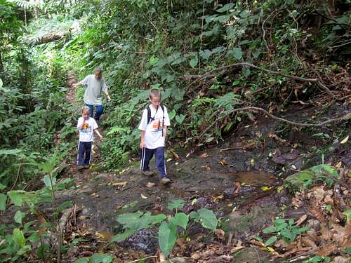
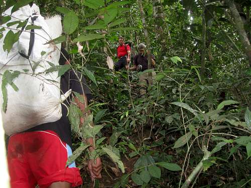
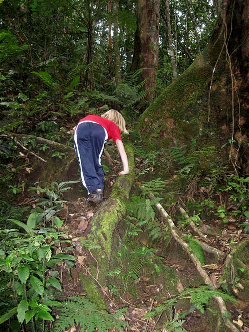
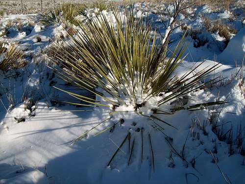
December 27: Hutan Wiata Carita (Java, Indonesia)
Today Kessler, Shaylee, Kimberly, my Dad and I went to hike in the Hutan Waita Carita (Forest Reserve) in the mountains east of Carita on Java. We explored several side paths before heading up the main path towards the waterfall.
The trail started out really easy, but gradually got more challenging as we progressed along. The most challenging part of the route was crossing several (recent?) landslides. Along the way we saw a giant millipede, a giant centipede and a weird horned spider (which was also very colorful).
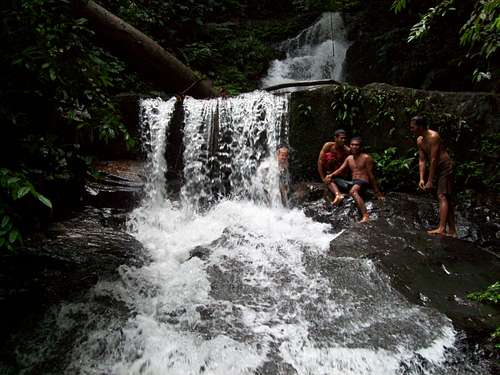
We ate lunch at the falls and we spotted several monkeys. After watching the monkeys we headed down the path to locate a steep and exposed (and exciting) trail to the bottom of the falls. Kimberly and Shaylee stayed there while Kessler, my Dad and I swam up through the slot canyon (which was quite challenging) to visit the bottom of the falls.
After visiting the bottom of the falls, Kessler and I walked and swam down the canyon to another falls. We then climbed out of the mini-gorge and returned to our lunch spot before descending the main trail a ways. We found a steep side track and decided to explore it.
The side track split several times as it climbed into the mountains and through some banana fields and I was hoping that we could follow it to the summit of Manlalawangi (mountain). Unfortunately the trail eventually petered out before reaching the summit of the mountain so we didn’t get to climb to the summit. After the tracks ended we headed back down the steep track to the main trail which we followed back to Carita. It was another fine day.
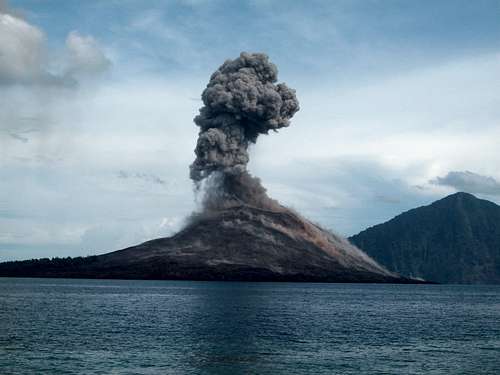
December 25-26: Anak Krakatau (Java, Indonesia)
Wow! How can I possible describe what we saw and experienced. This place was the single most spectacular natural scene that I have ever experienced. We (Kimberly, Kessler, Shaylee, my dad and I) left Christmas morning for Anak Krakatau under perfect weather. I had to take motion sickness pills because the only way to get there was by boat, but riding the motorboat was much easier on me that riding a ferry or big ship.
Explosions from Krakatau could be heard from a long way away. We boated to Rakata Island (part of the old caldera and did some snorkeling (seeing many tropical fish), but my dad ended up losing his watch in the ocean.
After snorkeling at Rakata Island, we got in the boat and rounded the bend to see the spectacular erupting Anak Krakatau which was exploding quite loudly. Obviously climbing the peak was out of the question. We headed to Sertang Island in order to see the explosions which were amazing to watch. After camp was set up my dad and I hike the beach in both directions as far as we could. We made it quite a ways, but were eventually cliffed out. There were some crabs to see and the beach was nice.
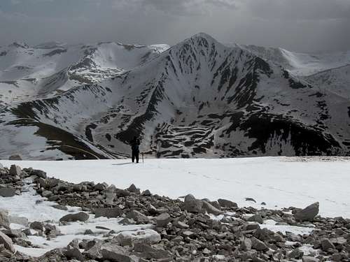
We thought the day eruptions of Anak Krakatau were spectacular, but then night came. It was incredible and lava bombs would explode and make it all the way to the ocean without hitting the ground. Using the known height of the volcano, I estimated that the big eruptions were shooting glowing lava 1000-1300 feet into the air (~300-400m) above the top of the volcano, setting the entire volcano aglow with red hot lava. It was an incredible scene and very noisy. I’ve never seen such a spectacular natural scene and we all agreed on this.
It was very warm at night and Kessler, my dad and I slept under the stars in order to see more of the volcano. We didn’t get much sleep with all the spectacular fireworks and noisy explosions going off.
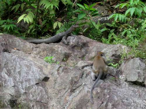
In the morning we were greeted by two giant monitor lizards (they must float to the island on driftwood unless they can swim this far?). After taking some more photographs we packed up and headed back to Rakata Island for some more snorkeling. We even found my dad’s watch and one of the boat operators was able to dive down and get it (maybe under 13 feet/4m of water?). Amazingly it still worked.
After snorkeling we headed back to Carita on the island of Java. Anak Krakatau sure was a spectacular trip!
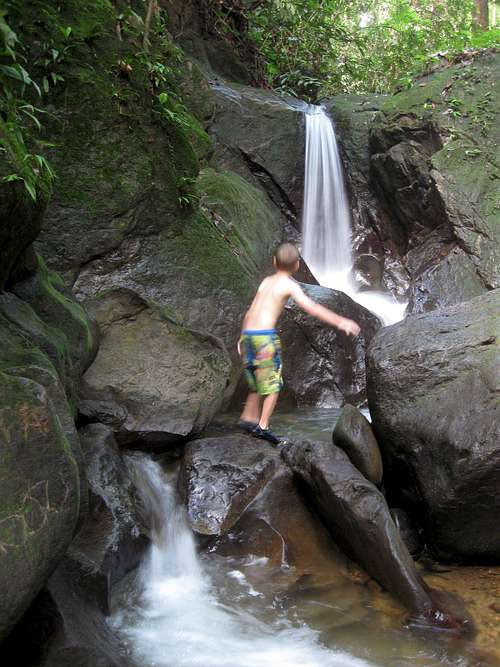
December 22: Tangkahan Waterfall and Hot Springs (Sumatra, Indonesia)
After a fantastic elephant trek and the experience of washing the elephant in the river the previous day, Kessler, Shaylee, Kimberly, my dad and I set off to hike to a waterfall and hot spring. We had to swim across the river to get to the hot spring which was tucked back in a shallow cave. We soaked in them quite a while before swimming back across the river and heading down river. We hiked downriver to a side gorge and hiked up it to a nice waterfall. Kessler, Shaylee, Dad and I climbed up and around the waterfall to find more waterfalls and pools up the slot like canyon.
It was a nice little hike.
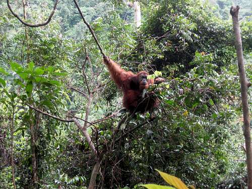
December 16-20: Gunung Leasur (Sumatra, Indonesia)
December 16
Today was our (my Dad, Kessler, Shaylee, Kimberly and me) first day of our exciting 5-day trek through Gunung Leuser National Park. Because of the wildlife in the park, you must have a guide to enter and trek in the park. Our main objective in trekking through the park was to view wildlife, but the scenery is really spectacular too.
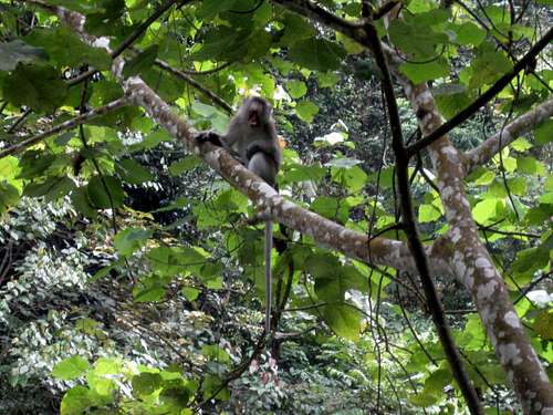
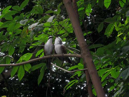
We started the trek at Bukit Lawang and were met by our guides there. After crossing the river in a very rickety canoe, our first stop was the Orangutan feeding platform at Bukit Lawang. This is where semi-wild orangutans are rehabilitated. We saw one orangutan along the way and another big male at the feeding platform. Several monkeys were around as well, including short tailed macaques, pig tail macaques and gibbons.
After viewing the animals, we headed out to the more wild parts of the park. The trails were quite steep and muddy, plus it was really humid and hot, so we were constantly soaked in sweat. Deeper in the park we saw more orangutans (which are much more wild than the ones at Bukit Lawang), including a mother and a baby.
After hiking half a day, there was a Thomas Leaf Monkey in the trees, so we decided to stop for lunch. We learned the lesson as to never turn your back on a monkey if you have a bunch of bananas. The monkey was afraid of us, but when our backs were turned, it quickly took advantage of the situation and stole our bananas. Nearby we saw many giant ants up to as long as my pinky finger.
After lunch we continued on the now more difficult trail across the steep ridges and to a river. Along the way we saw several white faced gibbons and more macaque monkeys and we got a few leeches. We were covered in sweat, so we quickly changed into swimsuits to soak in the river. There were several tiny frogs out and about. After a short time it started to rain hard, so we settled in the tent for evening. The jungle was really noisy with insects and animals.
December 17
Before we started our hike a large Black Gibbon came down to the river near our camp to drink. I quickly found the camera to photograph it. Once we were packed up we hit the steep trail. We were deeper in the jungle and the trail was more difficult than it was the day before.
We climbed over steep ridges on very steep trails and climbed at least two fairly prominent peaks. In many places the trail was non-existent (the old trail was taken out by a landslide and we had to take an alternate route) and the route was extremely steep. Everyone fell several times and one time I felt myself sliding down the mountain and into my dad whom I also launched down the mountain. Everyone got at least one leech and a few of us had more than one. It was a relief when we reached camp as it was a spectacular, but challenging day. We again went swimming to relieve our sweat soaked bodies before heading for bed.
December 18
Today was supposed to be a rest day of sorts, but we would still explore the area and visit some waterfalls. We awoke to heavy rain, so it was a good day for a rest day anyway. I went exploring down the river gorge until it dropped off a big waterfall. I took a swim and returned.
After an early lunch, the rain stopped and we headed up a side gorge to another impressive waterfall. It was a rugged and slippery route (and very wet). We played and swam in the waterfall, but I couldn’t climb it.
After returning from the waterfall, my dad and I headed up the main river gorge (while wading the river the entire time) to explore it. The route was extremely slippery and we both took several spills. At one place I waded through some vegetation and shortly after found out that I had several leeches. Yeck! I got rid of the ones I could and had my dad take the one off my back. We then headed back down the river gorge and back to camp.
After dinner my Dad, Kessler and I went to explore down river again. I found an exposed, but not too difficult route around the big falls and helped the others down. We explored the gorge downriver some more until it dropped off a big waterfall and into a huge dark hole. To continue down the dark hole with ropes must be a real adventure, but we had to return back to camp.
December 19
It was another rewarding and beautiful, but steep and sweaty day. We climbed over the top of three prominent peaks. Along the way we saw a very strange insect (Kessler called it a scorpion with no tail) and the jungle was very noisy with white-faced and black gibbons, though they were hard to see.
We almost walked right by a mother and baby orangutan, but Shaylee spotted it and we stopped to take some photographs of it.
Camp was a real paradise, my Dad called it the Garden of Eden. It was a beautiful location on a clear and fast river with high forested bluffs lining each side of the river. Monkeys were plentiful and playful and we saw three giant monitor lizards. One of the lizards jumped in the river and floated down through the rapids.
I found some huge big leaves and on one of them found a very colorful and shiny beetle. We had a nice bath and swim and settled down for our last night of our trek through the jungle. The fireflies were impressive that night and gave us a good show. It was a great day.
December 20
Today was our last day on our jungle trek. Actually we didn’t do that much trekking. We watched the monkeys and monitor lizards while packing up. Our group (guides) tied several big inner tubes together in order to form a raft. It was a very exciting (perhaps a bit too exciting) and we almost flipped once, but we all made it safely back to Bukit Lawang.
My Dad set off up river to explore around and view waterfalls. After taking showers for the first time in five days, Kim, Kessler, Shaylee and I also headed up river, but we stopped at the first big waterfall. It was a beautiful spot and a wonderful way to end our big trek.
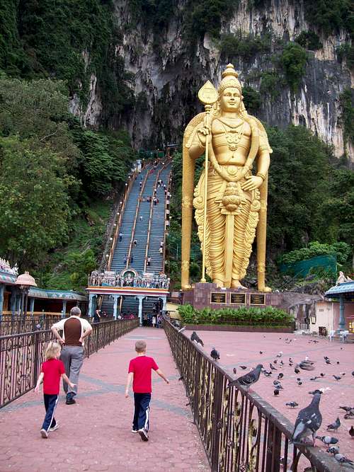
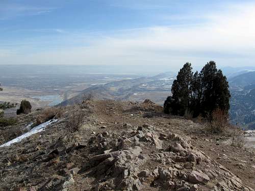
December 14: Batu Caves (Selangor, Malaysia)
Batu Caves isn’t really a hike (it’s more of a pilgrimage or tourist site), but we walked enough and it is interesting enough that it deserves at least brief mention. After reaching the base of the limestone bluffs by taxi we climbed up the long staircase (272 steps) and into the main cave. The main cave is a huge open natural cathedral laced with Hindu Religious sites. It is quite impressive and many mischievous monkeys are always dashing about.
We had hoped to visit the challenging Dark Cave as well, but unfortunately it was closed. We headed back down and walked around the limestone bluffs and to the too touristy but interesting Cave Villa.
Although it wasn’t much of a hike, it was all an interesting experience.
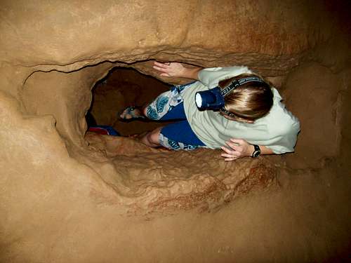
December 13: Gua Tempurung (Perak, Malaysia)
Gua Tempurung is a fantastic cave located near the nice city of Ipoh. We all (my Dad, Kessler, Shaylee, Kimberly and I) decided to give it a try. It was an incredible “underground hike” and perhaps the best cave I have visited, surpassing even Carlsbad Caverns. At first the cave is fairly easy with stone staircases (though it is quite hot and humid), but we took the more challenging route out via the watercourse. There were many slides and climbs and we had to crawl and swim on our bellies through crystal clear water. It was a fantastic cave and one of the best days ever. The kids really enjoyed it.
To top everything off, after the cave we rafted the river near Ulu Geruntum. We saw big black bees the size of tennis balls, many colorful butterflies and a gaint monitor lizard. There were two rafts in our group and our raft was lucky enough to make it through all the rapids without tipping. The other raft was not so lucky.
What a fantastic day!
December 12: Gunung Beremban (Perak, Malaysia)
From what we could see on our map, Gunung Beremban may be the second highest peak in the Cameron Highlands and since the highest peak has a road to the summit, we set out to climb the second highest mountain in the area instead.
After taking a short taxi ride from Tanah Rata to the Golf Course, we found the trail and headed up. It was a fairly challenging climb and was quite slippery and steep. We had to pay close attention to the map.
We heard many birds and animals, but didn’t see too many, but Kessler did find a giant (and colorful) roly poly big the size of a golf ball and I found a giant centipede. After 2.5 hours of hard climbing we found ourselves on the summit of Gunung Beremban. The views were somewhat limited due to tree cover and clouds, but it was a nice summit.
After enjoying the summit, we decided to head down the mountain via a different route. We took Path 8 down the mountain to the Robinson Waterfall. At first the trail was easier than the ascent route, but we had to cross a steep and difficult gorge with a fixed rope. It did rain a bit, which made the trails slippery. After the gorge, the trail descended very steeply down to the good and well used path near the waterfall.
We rested at the beautiful waterfall before heading down the good trail to the outskirts of Tanah Rata after which we walked back to the hotel.
December 11: Cameron Highlands (Perak, Malaysia)
After an all night bus ride from Singapore, we visited several sites and did several walks, including the one to the top of the Rose Valley and to near the top of the nearby peak. It was a nice and cool hike.
It wasn’t a hike, but the highlight of the day was seeing the giant insects at the butterfly farm.
December 10: Southern Ridges (Singapore)
After visiting some of the tourist attractions around Sentosa, Kessler, Shaylee, Kimberly, my Dad and I took a break from the city and set off to hike the Southern Ridges Trails. We hiked the Marang Trail, the Faber Trail, Henderson Waves, Forest Walk and various other trails. The forest is surprisingly beautiful so close the city and we saw many interesting insects and birds. We ended the hike near a Hindu Temple, which we visited before heading for the Golden Triangle to catch an all night bus to the Cameron Highlands.
December 4: Moonshine Wash (Utah)
My co-workers Justin Kuhn; Austin Gilbert and his wife Kelsey; Kim, Shaylee, Kessler and I headed down to the Green River area of Utah to explore some slot canyons. After a cold night at the Chaffin Geyser, we watched the geyser erupt before heading off to Sneak Canyon in the Three Canyon complex. It was noticed while separating out the gear that we accidentally left one bin of technical gear (including the helmets) at home, so instead of doing Sneak Canyon we headed instead to Moonshine Wash, which is non-technical.
Six year old Shaylee was excited to see the slot canyon so she ran ahead in order to be first to see it. We quickly made our way to the slot canyon and climbed down in. It was the first time that I had been through Moonshine Wash in 17 years. We enjoyed hiking down the slot canyon and climbing all the (minor) obstacles. We made our way through the slot and to the old historic sheep bridge where the canyon opened up.
After a quick lunch we headed down canyon to the Moonshine Spring slot, but found it to be full of water and ice. We abandoned plans to ascend the slot and backtracked into the main drainage and back up Moonshine Wash.
We climbed up to the west rim of the canyon and traversed to near the sheep bridge. Since it was fairly late in the afternoon, we eventually decided to skip the top of the sheep bridge and to head back to the vehicles. We took and exciting route back down into Moonshine Wash and headed back home. It was a nice trip.
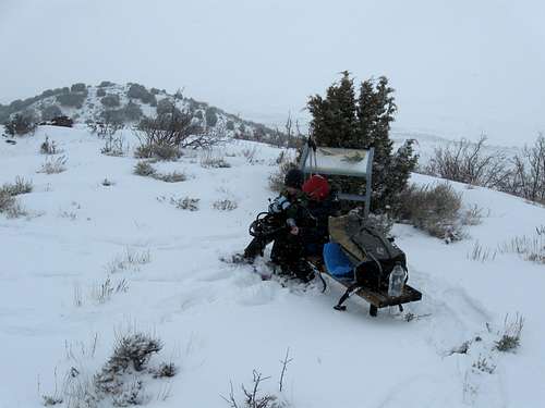
November 24-27: Janet's Cabin and North Sugarloaf (Colorado)
November 24
It was a long sleepless night for me. We were lucky since we made it to the hotel just before the blizzard really hit the evening before, but the howling wind pounding against the hotel windows made me nervous about the next day.
The blizzard howled all night, but by morning, the winds weren’t extreme. We drove to the trailhead (at Copper Mountain Ski Resort) where I dropped the kids off. We also learned that the lift we were supposed to take part way up was not open yet and that our route would be all over virgin powder. We weren’t supposed to park there however, so I drove back to the parking lot and walked the two miles back to where the kids and Kim were waiting. It was now late morning.
The kids started out wearing two pairs each of long underwear, fleece pants, wool shirts, fleece jackets, expedition snowsuits, down coats, undermitts, gloves, two pairs each of wool socks, -40 snow boots, facemask, neck gaiters and goggles. It was snowing pretty hard, but it actually wasn't bad starting out with temps of +7F (-14C), but it did get colder as the day went on.
Climbing up the ungroomed ski run was challenging in the deep powder, but route finding was easy even though visibility was poor due to the snowstorm. Since Kim has heart problems, I had to do all the trailbreaking, which was slow and hard. Visibility was poor and we made very slow progress up the mountains. Once we had to leave the ski run route finding became more difficult. When it was obvious that we missed the turnoff while route finding through the near whiteout, we traversed cross country through the thick forest (difficult) from one ski run to the other. It was now afternoon.
Since there was shelter from the bitter winds in the thick timber, I left Kim and the kids there to eat lunch and to have a break while I pushed the route farther (without my pack as breaking trail through the deep snow with a big pack on was difficult). We were at the top of the (closed) ski run and about to head out into the wilderness, but the visibility was poor enough that I couldn’t even see across the narrow ski run. I looked for the turnoff to Union Creek, but didn’t find it in the poor visibility. Since there wouldn’t be a broken trail anyway, I headed cross country west through the thick timber and to a finally to a point where the slopes dropped steeply into Union Creek. It took me an hour and a half from when I left Kim and the kids to get to this point. It was time to return to them. I was sweating despite the cold temperatures. Going back on my broken trail was much faster, but when I got to them it was 4 pm and the temperature was -16F (-27C) and breezy. I had only made it as far as 10,800 feet and we had a long descent to get down to Union Creek before breaking the long trail up the valley to reach the cabin at 11,630 feet. It was painfully obvious that we didn't have a remote chance of making the cabin so we turned around. We all stayed warm, but Shaylee said her toes were a little cold when she was waiting for me to break trail, which was just more motivation to head quickly down the mountain.
We made it down the mountain around dark and just when it was getting really cold. We spent the rest of the evening/night in the hotel. We made a visit to the hot tub and it was so cold outside that the glass walls around the hot tub were covered with ice on the inside. We had decided to wait two days before making another attempt to get to Janet’s Cabin. It was a rough day, but the kids did great, especially considering the brutal conditions.
November 25
As mentioned, we were going to wait until Friday to make another attempt to climb to Janet’s Cabin, but Thanksgiving morning was so clear, calm and beautiful that Kessler and I changed our minds (Shaylee and Kim decided to stay behind and in the hotel-they had enough brutality for now). It was -18F (-28C) in the morning, but there wasn't a cloud in the sky and the wind was calm.
We left the car with Kim and the kids and took a bus to Copper Mountain. We had to walk to the trailhead, but we were relieved that there was another big group there making an attempt to get to Janet’s Cabin. In fact, there were 16 people in their group (all of one extended family). We would have help in the trailbreaking! Not only that, they offered to give us a ride up a private road where they got permission to park and thus shortening the trip a little. They even had kids with them too!
We had some conversations with them and we told them about the brutal conditions the day before. We made quick progress up the trail that we broke the day before. The going was much easier on the broken trail and once we reached the area of the turnoff it was easy to find in the good (but cold) weather conditions. As we made progress however, all was not well. People in the other group began to get discouraged once we left the trail that our family broke the day previous. The going got more strenuous. As the time went on, people turned back at different intervals. Some got cold, some got tired and others simply got discouraged. Although we were tired, Kessler and I pushed on and broke the trail making the descent down to Union Creek through the trackless snow. Even though it was cold, we actually sweated breaking trail and I had to take off my down coat and fleece jacket and a long underwear shirt plus a light wool shirt were more than adequate. It was very hard breaking trail. Alone and tired we stopped there for lunch. We still had a long way to go.
As we were eating lunch, finally part of the group caught up to us. It was Dan and his 14 year old son Jackson. He told us that everyone else (14 people) had given up. We were tired from breaking trail so Dan and Jackson went on ahead to break the trail on skis (we had snowshoes). Their broken trail was a great help, but with my extra weight I couldn’t keep up with my son Kessler. It took us a very long time to get up the valley and Kessler went on ahead to reach the cabin. I kept punching through the snow in the willows. Following the skiers, Kessler reached the hut right at dark, but I was still 30 minutes behind. The sunset was gorgeous, but we were in too big of a hurry to take photos.
Thanksgiving was a very hard day, but the weather was actually good and even above 11,000 feet, the temperature probably reached 0F (-18C), which is actually quite pleasant if it isn't too windy. The hut was supposed to be booked to capacity (20 people), but it felt empty with just the four of us.
Two SP members, Tony (Tonka) and his wife Krista were supposed to meet us at the cabin, but we weren’t sure if they would make it or not. Long after sunset, headlamp flickers in the valley far below told us that they were on their way. We were glad to see them when they finally reached the cabin. We were also able to get cell phone service at the cabin, so we called Shaylee and Kim and told them that we made it to the cabin safely.
November 26
Sometime Thursday night the temperature dropped down to at least -20F (-29C) which is the lowest Tony's thermometer would register (I had left my digital thermometers in Kim's pack and she was back at the hotel), but by morning it was much warmer with -2F (-19C) and it was snowing.
Because it was snowing again and because of the brutal conditions the day before, and for Dan and Jackson the rest of his group was gone and because Tony wasn’t feeling well, all of the others headed back down the trail late morning. After waiting around for better weather, later Kessler and I set off to climb the peak north of Sugarloaf Peak (the only one that appeared free of avy danger, which is why I chose that one).
Not long after we started climbing, the weather cleared and the views were gorgeous and the wind was only a slight breeze. The trailbreaking was a little hard in some places, but easy in some places where the snow was windblown. As we were climbing the peak we got some great photos, but unfortunately my camera died before a very spectacular sunset and I didn't get photos of that (spare batteries were left in the hut). It was a great day and after clearing the weather was gorgeous. The trip to date had been well worth the effort, despite the journey being a lesson in brutality. That night, the cabin was strangely lonely since it was supposed to be booked solid (20 people), yet Kessler and I were the only ones there.
November 27
Today was a different world in comparison to the previous two days. Even at sunrise the temperature was a warm +14 (-10C) degrees. The weather was beautiful and there was no wind, nor was there a cloud in the sky. There were no hints at all about the previous hardships in the past few days.
After eating breakfast we set off down the mountain. Conditions were warm, calm and the going was easy with the now nicely broken trail. I had to strip down into my wool shirt and light pants since we were sweating in the sunshine. We made very quick progress on the descent, even on the long re-ascent up the slope after leaving Union Creek. When we reached the top of the ski lift, it was now groomed. None of the hardships were present. We met a group climbing up the run to the cabin and chatted with them a while before heading down the mountain. I assume they enjoyed are broken trail, but I wondered if they knew what a struggle it was to break that trail to the cabin.
At the bottom of the trail we were met by another local that was familiar with the route to Janet’s Cabin. He was very impressed that we had come from there since Kessler was only eight years old. I didn’t bother telling him that we were the ones that broke much of the trail to the cabin and we quickly parted ways. We had a daughter/sister and wife/mom that were patiently waiting for us in Frisco.
November 20: Sand BM (Colorado)
I had to work today, so Kessler and I went for a night climb of Sand BM. It was overcast and rather warm (for the time of year) and windy.
November 19: Fortification Rocks (Colorado)
Today right after the kids got out of school we decided to hike to and try and climb some of the Fortification Rocks. Unfortunately, the roads were horribly muddy (and scary in a few places) and we were worried about getting stuck.
Hiking up to the rocks involved quite a bit of mud and snow and it was quite windy, but we made it without incident. Kessler and I climbed one of the highest rocks and I tried to climb another high one, but chickened out 20 feet from the top.
It was a nice outing, but we wouldn’t go again when conditions were so muddy and wet.
November 13: Duffy Mountain (Colorado)
Kessler and I decided to climb Duffy Mountain today. It was a windy, cold, cloudy and gloomy day, but we needed to get out. We wore hunter orange just in case hunters were about since it’s still that season.
After driving to near the Bone Trail trailhead over frozen mud, we set off towards the mountain. Kessler suggested that we try and find a more direct route over the big cliff bands. It didn’t look too promising, but I told him we could try anyway.
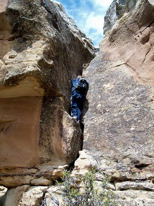
We climbed the very steep talus slopes towards the cliff bands and our route looked like it would dead end into the face of a wall. When we got closer to the wall we noticed that part of it was less than vertical and perhaps offered a slight chance of having a route through the cliffs.
When we got to the base of the cliff face, we noticed that we could climb the lower 1/3 of it by using several ledge systems. The middle 1/3 was 4th class and fairly easy, but the upper 1/3 was quite challenging and a bit scary. We had to traverse some narrow ledges to a crack system which lead to the top of the cliff band.
The second cliff band was easy and we quickly made our way to the summit area. It was quite windy and cold on top, but we didn’t want to descend the same route so we headed west and towards Signal Butte where we knew an old 4wd track descends the mountain.
I had forgotten how far it was over to Signal Butte, so we decided to try and find a short cut route along the way. Finding a route down through the big cliff bands is harder from the top because you can’t see if a route goes or not. We actually tried several dead end routes while we walked the long crest of the ridge. After reaching the cliff bands almost at the point above the Yampa River, I finally found a route down that was reasonable. Once we passed a few scary ledges and one down climb, we were home free and it was just steep mud and talus, but we still had a long road walk back to the vehicle.
October 31: Un-named Williams Fork Mountains
Yesterday I had to work and this morning I was home with a sick daughter, so when Kessler got home from church, he and I went to the Williams Fork Mountains. We climbed a steep and un-named peak. There were several cliff bands on the peak, and there were bypasses around them, but Kessler wanted to climb several of them directly.
After resting on the summit, we returned to the trailhead.
October 23: Sand BM (Colorado)
It was a stormy day and between storm breaks I had yard work to do (before our yard is covered with snow), but I managed to do a night climb of Sand BM in cloudy, but not rainy weather.
October 15: Malad Gorge (Idaho)
Kessler, Shaylee, Kimberly and I stopped at the Malad Gorge State Park in Idaho in order to break up the long and monotonous drive to Boise. We started at the Devils Washbowl (waterfall and pool) hiked the south rim of the gorge (with a short side trip to cross the bridge and back) all the way to another big waterfall, taking a look at several crack like caverns along the way. It was a nice and scenic hike along an otherwise unimpressive drive. The gorge itself was a nice surprise and well worth the stop and hike.
October 10: Cedar Mountain (Colorado)
I had to work on Saturday, so Kessler, Shaylee, Kimberly and I climbed Cedar Mountain after church. There were some light sprinkles on the drive and it was cloudy, but the weather was almost perfect for climbing the mountain.
We completed the long loop and were back well before dark.
October 3: Donut Falls and Silver Lake (Utah)
We (Kessler, Shaylee, Kimberly and I) met old friends, Jason and Randy Wardle, plus all their kids and wives and my dad and a niece. Because of all the small children, we needed a few easy hikes. We chose Donut Falls and Silver Lake.
Donut Falls was a nice little hike for the kids. Some of the littlest ones got tired and we carried them. After enjoying the falls, we headed to Silver Lake to eat lunch.
After lunch we did the loop hike around the lake, while enjoying all the nice autumn leaves along the way. It was a beautiful fall hike.
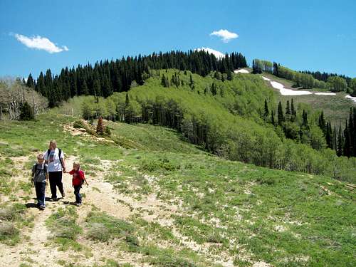
October 2: Kessler Peak (Utah)
We were in Salt Lake visiting friends and family and listening to a church conference, so we decided to climb a mountain while we were doing it. My dad, Kessler, Shaylee, Kimberly and I set off for a climb of Kessler Peak (the mountain my son is named after) in the Wasatch Range.
We started near Donut Falls and chose the north route up. It was a bit challenging finding the start of the route, but once on it, it was easy to follow. Most of the route is a very steep old mining trail. Shaylee (six years old) had a bit of trouble with it (she stayed up very late the night before) and she fell a couple of times. We got a late start, but made the summit without stopping much, though we did stop a few times to make sure Kim’s heart is safe (she has a heart problem). After enjoying the summit we headed back down the mountain and Shaylee slipped on her bottom again.
It was a longer climb than expected and was a bit less fun than some other peaks in the Wasatch, though the views were great. We met one other person on the lower slopes of the mountain, but otherwise had the peak to ourselves.
September 25: Bears Ears (Colorado)
Kimberly, Shaylee, Kessler and I joined with the girl and boy scout groups for a campout. At 5:30 am we all woke up to climb the Bears Ears and watch the sunrise. Everyone climbed up the steep mountain with few problems. After watching the sunrise, we headed back down the mountain.
September 19: Cedar Mountain (Colorado)
I had to work Saturday, so we only had time for a short trip. In the afternoon, Shaylee, Kimberly, Kessler and I climbed Cedar Mountain and completed the loop hike just before sunset.
September 13: Point 8143 (Colorado)
Today after work, I attempted a climb of Peak 8479 south of Meeker. I had planned to see if I could first get to point 8143 and then follow the ridge south. As my route, I chose a game trail that looked promising, but eventually the game trail contoured the mountain rather than going up the ridge. I made my way through the brush, but it got thicker and thicker as I went higher. After a lot of hard work and after ripping my clothes and losing some skin I decided that my route wasn’t worth the effort. I returned back down the mountain unsuccessful.
September 12: Sand BM (Colorado)
The kids were being a bit wild, so it was time to separate them for a bit. Kessler and I went for a late evening/sunset climb of Sand BM. We saw many deer along the way to the summit.
September 11: Mount Democrat (Colorado)
Today Kessler, Shaylee , Kimberly and I decided to climb Mount Democrat. Mount Democrat was chosen because Shaylee wanted to do a 14er and it was the closest 14er to our house that I already haven’t done and since we missed this one last year when we climbed the other nearby peaks. It was also a short climb and I needed to get back early because I had things to do.
After driving to the trailhead we set off for the summit at 8:30 am (in summer it would be better to start earlier, but there was no threat of thunderstorms today). We made it to the summit in a fairly fast 2 hours 20 minutes, taking two rests along the way. After spending nearly an hour on the summit we set off back down to Kite Lake. It was a perfectly clear day with not a cloud in the sky.
September 7: Un-named Grand Hogback (Colorado)
Today after work, I went for a climb of a name-less peak on the Grand Hogback near Meeker. There was some pretty thick brush on the route, but I found a deer/elk trail that penetrated the worst of it. O reached the summit just before sunset and returned down the mountain in the twilight.
September 4-6: Capitol Peak (Colorado)
September 4
Yunona (seven years old), Alice (five years old), Rostislav, Elena met our family in Craig the night before the climb. Kimberly (my wife) and Shaylee (my daughter) decided to stay home last minute because of my wife’s concern with her heart problems. Only Kessler and I would join the others for the climb of Capitol Peak.
We drove to the Capitol Creek trailhead in the morning, arriving in early afternoon. The road was quite rough and we scraped bottom with our minivan a few times. We met Aiden at the trailhead and headed off towards Capitol Lake, making the hike in 4.5 hours. The kids played at the lake and we watched the sunset before going to bed.
September 5
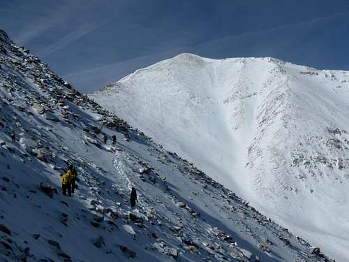
Today was the big day and since there wasn’t a thread of thunderstorms, we set off for the mountain at 6:30 am.
We made our way across the traverse of the basin and Alice and Elena stopped at K2 to wait for the rest of the group.
The rest of us made our way to K2 and across the Knife Edge where Kessler and I split from the rest of the group. There were lots of fun little obstacles and Kessler and I climbed to the summit (five hours) and enjoyed the views while waiting for the others for about 30 minutes. After enjoying the summit we headed back down. The Knife Edge was interesting in windy conditions, but we made the climb safely and headed back down the mountain. It was a nice climb.
September 6
Today it was a rather leisurely hike back down Capitol Creek to the Trailhead. A cloudless day rounded off the nice weekend.
August 30: North Hogback (Colorado)
Tonight after work I went on a quick climb of North Hogback Peak. I hurried up the mountain fast in order to get back by sunset. The route I took had a short section of nasty brush and I ended up with a big rip in my backpack. I took a few photos from the summit and headed quickly down, but unfortunately ran into another section of brush. I made it down the mountain just after sunset.
August 28: Cougar Mountain (Colorado)
It was raining so the kids didn’t want to climb the peak. Kimberly and I found a baby sitter and set out to climb the peak.
We drove to the trailhead in cloudy weather and as soon as we started the climb it began to rain. It rained on and off all the way to the summit, but it was never raining hard and wasn’t too bad.
There wasn’t much in the way of views from the summit, but I startled an elk herd and we were watched by a deer. The hike down was uneventful, but pretty slippery due to wet vegetation.
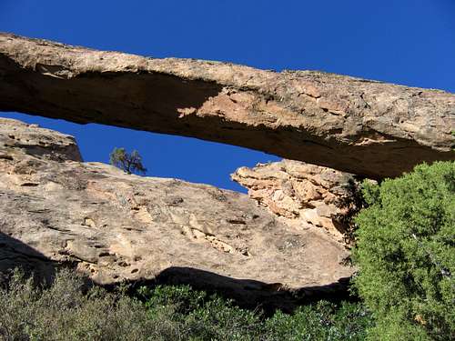
August 26: Rifle Arch (Colorado)
After work, I hiked to Rifle Arch with one of my co-workers (Cecil Cubbeson) since the hike was close to where we were working. We hiked to the arch and did some scrambling behind it leaving just before sunset.
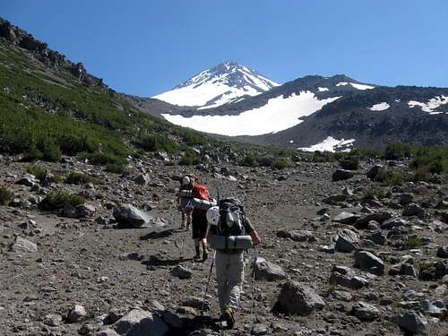
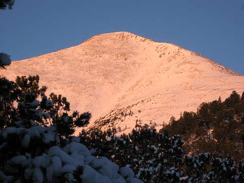
August 13-15: Mount Shasta (California)
August 13
We rode with (another) Scott and Julie to the trailhead and it was 12:30 PM before we finally set off up the mountain. It was sunny and rather hot and dusty. We stopped for a break every hour (we wished they stopped a little more and that we had an early start), but we made it up to camp (9400 feet) at 4:30 PM. The weather was good (but warm!) under perfectly clear skies and the camp was in a beautiful setting. Even though we duck taped her feet, Kim got a few blisters as well (I was the only one in the group who didn’t).
After setting up camp in the late afternoon and early evening, there was a snow school before dinner. Since we had to get up early the next morning, we went to bed pretty early, but I couldn’t sleep, partially because the wind picked up and was flapping the tent all night and partially because I had a lot on my mind.
August 14
Today was the big day, but I was sad that Kim couldn’t join me. I gave her a kiss and we rolled out of bed for a 2:30 AM breakfast. The stars were wonderful this early and we just happened to be here during the Perseid Meteor Shower. What perfect timing for a climb and what wonderful timing for perfectly clear skies!
After breakfast (and being treated to several shooting stars) we quickly packed up to climb the mountain. Scott (the other Scott) had apparently pulled a muscle the day before and decided to stay behind. I had packed up the night before and had time to kiss Kim goodbye and to tuck her back into the warm sleeping bag.
It was a beautiful night (morning) for climbing and the shooting stars were impressive, but my mind just wasn’t on the mountain. I kept thinking of how much I loved Kim. I could put one foot in front of the other and could bury my axe in the ice, but my mind was on her. I was distantly aware that the sunrise was beautiful, but for some reason, it also seemed a bit lonely and I was a bit detached from all the beauty that was around me.
Gradually the weather became warm and bright as we (I was on the rope with Julie and Nick guide) and Mike, Kammi and Natalie guide were on a separate rope) trudged up the steep ridge. The steepness was sustained, but never that icy nor was it overly steep. We were above all the crevasse obstacles and didn’t have to cross any crevasses on this route. I hoped I didn’t bother the rest of the group too much, but I did talk about how much I missed my wife when we stopped for a break. Even though I have climbed many mountains alone and was attached to others on a rope, I have never felt so lonely on a climb.
After a traverse and a steep gully we could unrope. Mike and Kammi were younger and in better shape than us, but I was feeling really good at this point and asked if anyone would mind if I could run ahead and catch them. I was told that I could and did just that.
I summitted with Mike, Cami and Natalie and while eating a snack and enjoying the view we waited for Julie and Nick. I sat alone part of the time and spent a little time taking photos of the others and of the view. For some reason I can’t comprehend, I turned down the offers from the others to take a photo with my camera of me on the summit. The others didn’t have a working camera, so I took photos of them.
Although I was perhaps in not quite as good of shape as at least a couple of the others on the mountain, I was (perhaps selfishly) in the mood to get down the mountain. I prodded a bit to be able to glissade down the mountain (I am very accustomed to glissading down steep slopes), but I wasn’t allowed (I was disappointed, but I understand why they don’t like people to do it). Finally half way down, the prodding paid off and I glissaded down the mountain. I was ahead of the rest of the group so I climbed back up the mountain in a few places to get some more rides back down.
I was very happy to see Kim when I was finally down the mountain and we gave each other big hugs and kisses. While the rest of the group rested, took naps, or chatted, Kim and I built little rock hearts around camp with the letters “S+K” in them. I was very happy to be married to such an amazing and wonderful woman. After building several rock hearts, we chatted with the rest of the group before dinner and bed. It was another very windy night with a little rain.
August 15
We awoke at 6:45 AM and packed up the bulky tent, which was a bit challenging in the strong winds. It sprinkled a little bit and after breakfast we hurried down the mountain. We left camp at 8:30 AM and were back to the vehicles at 10:30 AM where we said goodbye to our new friends.
Scott and Julie offered to give us a ride back to Redding so we wouldn’t have to wait for the Greyhound bus. We bought them dinner along the way.
August 7: Sugarloaf Mountain (Colorado)
Kessler was at a Cub Scout day camp today and Shaylee didn’t want to climb a mountain so I set off alone to climb Sugarloaf Mountain which is closest peaks to our house that I still haven’t climbed yet. I got a late start and climbed the mountain from the west.
The climb was pretty rugged and somewhat tedious in sections, but non-technical. It was cloudy and with distant thunder far away, but the weather wasn’t threatening on Sugarloaf and other than a few sprinkles, the weather wasn’t bad.
I found a route to the summit plateau and circled the entire rim looking at various viewpoints, until I climbed to the true summit which I found was the northwest point. I was the first person to sign the new register since it was placed five years ago. The old register had three signatures since 1980, making a total of five signatures in 30 years, so I guess this is a lonely mountain by Colorado standards.
I took a different way down, but it was harder, steeper and had quite a bit of loose rock. It took longer to descend the mountain than I thought it would. By the time I got home, there was pouring rain so the climbed was timed perfectly.
August 1: Cedar Mountain (Colorado)
Shaylee, Kessler and I went for a climb of Cedar Mountain under threatening skies. We drove to the trailhead and did the short loop with only a few light sprinkles, though we could see that it was raining harder in other areas. We got back to the vehicle just before dark.
July 31: Emerald Mountain, Yampa Corridor Trail and Seven Springs (Colorado)
Originally we were supposed to do a really special mountain today, since it was Kessler’s 200th mountain. The weather forecast was too poor to climb something like Capitol or Gold Dust peaks.
Instead we headed for Steamboat Springs. First we (Kessler, Shaylee, Kimberly and I) tubed down the Yampa River. We then set out to do the (easy) Yampa Corridor Trail and the Seven Springs. We didn’t find Sulfur Cave so we climbed up the east summit of Emerald Mountain instead. It was a steep and hot climb since the bad weather that was forecast never materialized.
After climbing Emerald Mountain we headed to the top of the alpine slide on Howelsen Hill. We were allowed to slide down for free.
It was a hot day (2nd hottest of the year and missing the hottest day by 1 degree) and since the bad weather never materialized we wished we had attempted a higher elevation mountain. It was still a good time, if a bit warm.
July 25: “Rattlesnake Peak” (Colorado)
Kessler and I decided to do an evening climb of an un-named peak in the Williams Fork Mountains. We drove to the trailhead and found that the mountain had a lot of cows on the lower slopes. Since it was nearly dark, meeting the cows in the brush was kind of spooky.
By the time we summitted the peak it was dark and we heard a rattlesnake rattling. We never actually saw the snake, so it’s a good thing that it did rattle and warmed us. We turned around and headed back down the mountain, deciding to call this previous un-named summit, Rattlesnake Peak.
July 24: Pyramid Peak (Colorado)
Kessler, Shaylee, Kimberly and I set off for a climb of Pyramid Peak in the Flat Tops today. We got a fairly late start, but the weather was good.
We didn’t find the correct start of the trail (on the way back we learned that the sign was missing) so we bushwhacked up the slope to find it. It was slow going and it took us a while to cover only a short distance, but we found our way to the trail after 30 minutes.
We continued up the trail at a much faster pace and had a break at a saddle where we got our first really good view of Pyramid Peak. We continued up the trail and spent some extra time climbing two nearby peaks (one of which was a rough scramble) before making our final approach to Pyramid Peak. We scrambled up the Southeast Ridge of Pyramid Peak and found that the last section of the ridge was quite interesting.
We didn’t spend that much time since our side trips to the other nearby peaks ate up quite a bit of time and it was already getting fairly late. By then the kids were pretty tired so we set off down the mountain for the long walk back to the trailhead.
It was a good climb, but since we climbed three peaks, it was a long day.
July 18: Courthouse Mountain (Colorado)
Kessler and I didn’t make the decision of which mountain to climb until the morning. We decided on Courthouse Mountain in the San Juans, since it wasn’t a long climb and since we still had a long drive ahead.
After driving to the trailhead, we set off up the mountain. We met Sarah and Deb from the day before just after starting up the mountain.
The mountain was a short, but fairly steep climb and is very scenic. It looks fearsome from the west, but from the east, it’s a nice class 2+ climb, mostly on a fairly steep trail. There was some minor scrambling before we reached the summit area. The true summit had a nice little scramble along a narrow ridge and a climb through an interesting notch. The views from the summit were fantastic. After enjoying the summit and watching a mischievous golden mantled squirrel, we headed back down the mountain. Kessler ran down the mountain with Sarah and I couldn’t keep up (at least not without trekking poles). I was hoping to give Kessler my earned Princess title (see previous day), but was unsuccessful. Next time I’ll bring Kessler’s little sister (Shaylee) so I at least have a chance of not being the Princess!
July 17: Whitehead Peak; Mount Rhoda and Peak 13,434 (Colorado)
This climb was part of the 2010 Summitpost gathering in the San Juan Mountains. Kessler and I decided to join the activity. The group met at 5:45 AM at Silverton. We carpooled to the trailhead, but there was some confusion as to where the trailhead actually was, so we ended up walking some extra distance.
We followed the trail up to near Highland Mary Lakes to where we left the trail and climbed up Whitehead Peak. After climbing Whitehead Peak, we climbed the ridge south over to Mount Rhoda where we all had a short rest. Most people went around the cliffs back to the ridgeline, but Kessler and I climbed down the cliffs directly, just for fun.
The group then climbed over to Peak 13,434 where we had lunch. It was also decision time. There were some poofy clouds to the east, but the wind was coming from the southwest where it was clear. I thought we’d be OK to go on to the next peak (especially since the rest of the ridge was gentle), but was outvoted.
All three peaks we climbed over had some nice views of the more rugged peaks in the San Juans including the Grenadiers and Needles.
After enjoying the views we all headed back down the mountain through the Spencer Basin. I stopped in the Spencer Basin to talk to Aaron and other members of the group, but I had to almost run down the mountain to catch up with my son Kessler. We had made a deal that the last one of us down the mountain was a princess. I guess I can be called Princess Dad for the next little while.
July 13: Un-named Grand Hogback (Colorado)
In the evening, I set out to climb one of the un-named peaks in the northern section of the Grand Hogback. I wanted to connect the ridge to the peak “North Hogback” which I had already climbed, but once I reached the first peak I was tired enough since it was a brushy route. I didn’t even stop on top, but just went over the top and back down another route.
July 11: Un-named Peak/Williams Fork Mountains (Colorado)
Kessler and I made a good late afternoon to sunset climb of an un-named peak in the Williams Fork Mountains, not far north of Hamilton. The peak had an obviously class 2-3 route up, but Kessler wanted to take on the four cliff bands directly in order to make it more challenging. We found challenging routes up all four cliff bands before topping out on the ridge which we followed to the summit. On the way down we found an old mine and some wooden ladders bypassing one minor cliff band and a few more old artifacts. It was a nice climb.
July 5: Saddle Mountain
Kessler and I made a climb of Saddle Mountain in the Elkhead Mountains. The peak turned out to be more challenging than expected (but not difficult) and consisted of either steep slopes, slippery ground or scrambling. It took longer than expected. Surprisingly we met two other climbers on the summit, which is a very rare experience in the Elkhead Mountains.
Descending the mountain was slippery and Kessler skinned his knee on a rock. Other than that it was a good climb.
July 4: Sand BM (Colorado)
Shaylee, Kessler and I made an evening climb of Sand BM. It was unusually cold and wet for July 4th.
July 3: Black Mountain (Colorado)
Kessler, my Dad and I climbed Black Mountain today. We took the Southeast Ridge Route since it is the fastest route and since we had a family activity later that afternoon that we had to be back for.
There was only a little snow on the trail, but as usual for early July there were several big snowdrifts on the summit plateau. Kessler played on the snow for a bit before we headed to the easternmost point on Black Mountain for the views. After enjoying the views and a snack we headed back down the mountain.
July 2: Upper Fish Creek Falls (Colorado)
Shaylee, Kessler and I decided that it would be a good for our annual hike to Upper Fish Creek Falls. We usually do the hike in June (when the waterfalls are most impressive), but we missed it this year.
We hiked down to Fish Creek Falls and found that the falls still had a high volume flow. We continued on to the upper falls, but the kids were tired because they stayed up late the night before. After reaching the Upper Falls we took a long rest before heading back down to the trailhead.
June 27: Sand BM (Colorado)
Because I went river rafting Saturday, I didn't have much time to climb a peak. Sunday evening, Kessler and I climbed the Sand BM and arrived back home just before dark.
June 24: Smith Gulch (Colorado)
Today after work, I went for a hike up Smith Gulch west of Meeker. I originally thought of climbing Black Mountain (the one west of Meeker), but I decided that I didn’t have the energy.
June 20: South Cross Mountain (Colorado)
Because of our long hike yesterday, Kessler, Shaylee, Kimberly and I decided on an easier hike for Sunday afternoon/evening. We headed for Cross Mountain, perhaps the most spectacular summit in our general area.
We hiked to the summit of South Cross Mountain and enjoyed the views from the summit for a while before heading back down the mountain.
June 19: Baldy Mountain (Colorado)
Baldy Mountain, in the Flat Tops near Marapos Creek is a summit that has been on my list for a long time. Kimberly, Kessler, Shaylee and I tried to climb the peak in June 2008, but there was too much snow (without snowshoes). 2010 was a lighter snow year, so we thought we’d give the mountain a try.
From Marapos Creek, we started up a trail past some beaver ponds and made our way along a trail to the south side of Baldy Mountain. We then climbed the trail to the ridge east of baldy, hoping to climb some peaks along the Sleepy Cat Ridge. We did manage to get over one peak before lots of snow and downed timber turned us back. We then climbed over the ridge to the north and made our way down to the east ridge of Baldy Mountain which we followed over the summits of Baldy itself.
We then tried a steep route on the west face of Baldy, but it was harder and more time consuming than expected. On the way down we saw a big elk herd of around 100 head, including mothers and calves. Since we didn’t know it was there, we accidentally startled the elk herd and they headed up the mountain, but left a calf behind. The calf began to follow us rather than the herd for a little bit and I became worried. I attempted to direct the calf towards the herd and hoped that I was successful since the elk calf was calling for its mother.
After some bushwhacking we made our way over to the trail which we followed back down to the vehicles. It was a long day and I figured (after we got home) that we covered 11 miles, much of which was off trail terrain.
June 13: Cedar Mountain (Colorado)
It was raining, snowing and hailing most of the day, so we scrapped our plans to do anything big in the afternoon. We (Shaylee, Kessler, Kimberly and I) took advantage of a break in the stormy weather to climb Cedar Mountain. We did the short loop and only spent 30 seconds or so on the summit. We had light rain, but it wasn’t too bad. It began to rain hard by the time we got back to the vehicle, so the timing was perfect.
June 12: Sand BM (Colorado)
It was a very stormy day, which put an end to any grandiose plans. I had hoped it would clear up, but that never happened. I spent much of the day trying to get yard work and other chores done between periods of rain. It finally did taper off in the afternoon and evening so I went for a quick climb of Sand BM. Needless to say, much of it was a muddy mess. I hope tomorrow is better.
June 8: North Hogback (Colorado)
Originally I had hoped to attempt Monument Peak, the highest peak along the Grand Hogback, but I worked a long day and was very tired. I opted to climb North Hogback instead. It was an uneventful climb other than seeing a bunch of sheep and a sheepherder along the way and I got to the summit right at sunset. It was a different climb that a month ago since everything is now green and there were many flowers about. I got back to the vehicle after dark.
June 6: Church Fork to Rattlesnake Gulch (Utah)
Originally we hoped to climb Grandeur Peak (in the Wasatch Mountains), but we (Kessler, Shaylee, Kimberly and I) were busy with family and we got a later start than we had hoped. Since we still had a long drive ahead of us, we decided to hike the Pipeline Trail from Church Fork to Rattlesnake Gulch (up Millcreek Canyon). It was a good hike, but it was also a pretty hot day. When the kids said they were hot we would dump water on their heads.
May 31: Mill Creek (Utah)
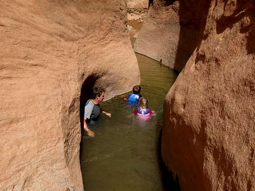
It was a hot day, so we drove from Green River to Moab in order to hike Mill Creek. Mill Creek is a good one in hot weather since there are many swimming holes along the route.
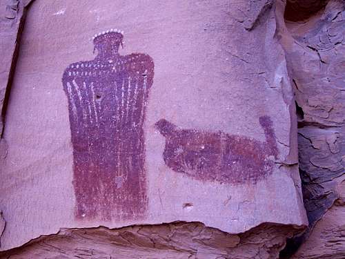
We hiked up canyon and into the North Fork, visiting many petroglyphs panels along the way. It was a challenge to avoid the poison ivy, but we did so carefully. After reaching the biggest pool and waterfall, we ate lunch and hung around. The kids like to swim in the pool above the big one and Kim and I slid down the falls and into the pool.
After getting completely soaked, we headed back to the trailhead in hot weather. We were glad that we were wet.
May 30: Peek-a-boo and Spooky Canyons: Utah
My dad had to get to Green River in the afternoon in order to catch the Greyhound Bus, so we had to do a relatively short hike today. We chose Peekaboo and Spooky Canyons, two interesting canyons in the Escalante region.
We left very early in the morning and headed for Peekaboo Canyon. Kessler and Shaylee loved the climb into the canyon and had a blast exploring it and climbing over the obstacles. When the slot widened to a wash, we hiked across the desert to the head of Spooky Canyon.
The kids really liked climbing through the canyon and due to the narrowness of the passage beat the adults through. After Spooky Canyon we headed to the slot in Upper Dry Fork. Kessler, my dad and I explored Dry Fork while Shaylee and Kim played in the sand in the shade. After exploring Dry Fork we headed back to the trailhead and drove to Green River where we did some church activities.
May 28-29: Fortymile and Willow Creeks: Utah
The original idea was to do a loop featuring Scorpion Gulch in the Escalante region, but we found that the road there was rougher than it used to be. Since we didn’t expect the road to be rough, we brought our low-clearance vehicle.
As a backup plan we (Kessler, Shaylee, Kimberly, my dad and me) did the Fortymile Gulch and Willow Creek Loop, which is no bad thing. The Fortymile Gulch/Willow Creek is one of the best and most scenic routes in the world. Some sources bill this as a difficult route, but our two kids had a blast on it.
May 28
After a late start (due to trying to drive the Early Weed Bench Road), we started down Fortymile Creek. The canyon starts out as an uninteresting wash, but after not too long it drops into a slot canyon. We bypassed the slot on the left and came down another side slot (rated by some sources as class 4) before dropping into the canyon and eating lunch.
After lunch it was down canyon. The best part of the canyon started at a waterfall. After avoiding poison ivy very carefully we bypassed the waterfall and continued down canyon. The canyon slots up and is filled with clear running water and became extremely beautiful. There were several sections to wade or swim through and this was the kid’s favorite part. It was a hot day and the water temperature was refreshing, plus the kids really liked all the fish and crayfish swimming in the water.
After continuing through the wading and swimming sections, we eventually found ourselves at the Willow Creek. Kimberly and the kids waited at the junction while my dad and I explored down canyon. We explored down canyon for an hour or so, but it was getting late so we returned back up to the junction. We all swam and waded up lower Willow Creek to where we found a small but adequate sandy bench to sleep on for the night. It was a nice place, but it was noisy with all the croaking frogs whose noise was echoed off the canyon walls.
May 29
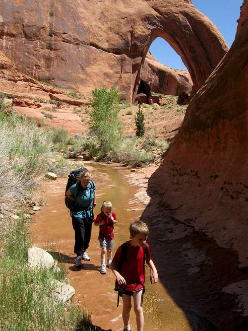
After waking up, we had a leisurely breakfast before hiking up Willow Creek. It was a great canyon in the lower end until we got to the huge Broken Bow Arch. We went and hiked up and around the arch before eating lunch at the pools and waterslides near the base of the arch.
After a good soak, we headed up canyon. Since we didn’t have a car shuttle, we decided to finish the canyon directly up to the road rather than exiting the standard route. Rumor was that there are some nice slot canyons up there. We negotiated the first slot without packs and Kessler thought that it was so much fun that he wanted to do it again (which we did). After retrieving the packs and heading up canyon we got to some more nice slots. We also found out that the slot canyon was blocked by a rattlesnake. We had to chimney up and over the snake, but it was exiting to say the least.
After exiting the slot we headed across the desert to the Hole in the Rock Road. We bumbled a bit since we didn’t have a good topo map of the route (because we were planning on doing different canyons rather than this one), but we made our way through the heat and reached the road not far (one mile or so) from where our car was parked. We got a ride for the last short distance. It was an awesome trip and one of the kid’s all-time favorites.
See the trip report for details:
Fortymile Gulch, Willow Gulch, Spooky Slot, Peekaboo Slot and Mill Creek
May 22: Mount Antero (Colorado)
My brother, whom has just moved to Leadville for the summer was eager to climb a Colorado 14er. I offered to join in for an attempt.
Of all the mountains I’ve attempted this year so far, this trip was almost doomed to failure from the start. The odds began stacking against us right away.
1. There was a high wind warning out with winds forecast to be 70-100 mph in the mountains.
2. I had a very long work week and was already exhausted before even leaving home. I had called Richard the evening before and said that I was already very tired and that it would be windy, but he was still interested in going and giving it a good try.
3. I didn’t even get home (in Craig) until almost 7:30 pm Friday night and wasn’t even packed yet. Yet, I had a three hour drive ahead of me.
4. In haste to leave town and start the drive, I left my ice axe next to the door at home.
5. We didn’t get to sleep until well after mid-night and as mentioned, I was very tired before even leaving home.
6. The night before was 42F degrees in Leadville and 55F degrees in Buena Vista which would mean very poor snow conditions.
7. Because we changed plans last minute, we didn’t have a map of the peak that we would be attempting.
In the morning we woke up early, but we had to scramble to try and find an ice axe in Leadville. Obviously it didn’t work. The only places that sold ice axes didn’t open until 10 am and we couldn’t find one to borrow. We were originally hoping to climb the west face of Mount Democrat, but with the warm night, it was thought that conditions would not be good. We switched our focus to Mount Antero.
After deciding to attempt Antero, we drove to Buena Vista to see if we could scrounge an ice axe there. We found someone to open a store early, but that wasn’t until after 8:30 am. We had at first thought of climbing the north couloir on Antero, but with the late start and warm temperatures, we weren’t sure if conditions would be good. We switched our focus to a variation of the standard route.
We drove 0.5 miles up the Baldwin Gulch Road before being stopped by a snowdrift. It was already after 9:30 am which is an embarrassing late start for a climb that would depend on finding hard snow. We hiked up Baldwin Gulch, which was a mix of postholing, mud and dry ground. Without snowshoes, we would sink into the snow to our knees or more in some places, but with snowshoes, there were many sections of bare rocks and dirt to cross. In the end, we didn’t use the snowshoes much.
We met another climber near the stream crossing. He had got an early start and had said that there wasn’t too much wind until the very top and that another climber was not far above him. We then made the tedious slog through the snow to timberline (the snow was slop by this time of day) and to a couloir of which we observed a climber near the top of. We climbed the couloir on fairly hard snow (thank goodness) and had a chat with the climber half way up. He was a 14ers.com member and he also said that for his climb there wasn’t that much wind until the top.
We climbed to the top of the couloir where we found that the wind really started to pick up. The front must have been crossing because the temperature dropped significantly as well. We made the tedious traverse around the mountain (which took us several hours with soft snow) and finally reached the ridgeline. Without a map and with somewhat poor visibility (most of which was actually due to dust rather than clouds) we weren’t exactly sure which mountain was the right one, but Richard (my brother) guessed correctly and we found our way up the summit ridge (we must have missed the standard route though, because there wasn’t a defined route through the talus).
The wind was really howling and it was hard to stand up, in fact it knocked us both down several times. When I stopped to wait for Richard at one place, I put my big pack down and it started to blow away! The wind really slowed things down and it was a battle just to get to the false summit of Antero at 13,820 feet. The wind was blowing harder than ever and it was getting cold. Worse, there was now a short knife edge ridge to cross and we were already having trouble keeping our balance and standing up. After a rest, it was already 5:40 PM. We were concerned about the late hour (I had to leave for Craig at 5:30 am the next morning) and we were concerned about being blown off the ridge or being able to keep our balance on the ridge during the gusting winds.
After a short conversation, we turned our backs on the mountain and headed down. It was a bitter blow (on what should have been an easy mountain) for many reasons:
1. May and August are the only months that I haven’t climbed a 14er (most of them I've done were in the winter season). I wanted to get May over with and it would also be a new record elevation for me for the month of May.
2. It was a lot of hard work getting to the false summit. It was a shame to turn around. Normally, I wouldn’t mind so much, but my impression of Antero is that it is a tedious and mostly unaesthetic (compared to many other mountains at least) scree pile and not on my list of places to return (the couloirs on the north side might be much more interesting).
3. It would have been Richard’s first 14er and he was looking to climbing a 14,000 foot mountain for the first time.
On the way up, I had noticed a snow slope that might prove a good glissade down. We made our way over the scree to where I thought the top of the snowfield might be. It looked steep, but not unreasonable. I went first and zoomed down the snowfield in fast time. It sure beat the postholing and scree on the way up. Richard quickly followed.
We found that we could glissade all the way down the snow slope to a couloir which led down to timberline. Some of the snow was icy and fast, but both of us are good with an ice axe.
Once we got to near timberline, the snow softened again and it was once again posthole city. We forced our way through the soft snow and back to the standard route. After that it was a long and tedious walk out and we arrived around dark. We went to bed late in Leadville and then it was a long and early drive home in the morning.
See the trip report for more details:
Mount Antero
May 16: Cedar Mountain (Colorado)
I had to work the first half of the weekend, so Kessler, Shaylee and I did the full Cedar Mountain Loop on the afternoon and evening. It was a beautiful spring day with perfect weather. Usually we are on the mountain alone, but this time we met on couple and one solo hiker. The last of the snow is gone and there are only a few wet spots left. It was a good hike.
May 13: “North Hogback” (Colorado)
This evening, I went for a climb of North Hogback. Originally I was hoping to find a route to the top of Monument Peak, but after a long day at work, I was tired and decided to climb North Hogback instead since I already knew the route from my climb on April 15.
This time I took a camera with me. This time there was no snow to walk through either and after knowing the route I was able to climb the peak quicker than last time. It was cloudy and I watched a small storm come in, but it wasn’t bad. After enjoying the summit, I headed back after it started snowing.
I decided to try another way down, but this was a mistake. I ended up in thick bushwhacking and had to make my way through the brush and up to the ridge. After fighting the brush for a while I found a game trail heading down the mountain.
May 8: “Jeffway Peak” (Colorado)
Today Kim, Kessler, Shaylee and I climbed the peak between Jeffway and Deal Gulches in the Williams Fork Mountains. I chose this one because I hadn’t climbed it before.
We found a route up to the top of the ridgeline, but there were some cliff bands to pass. Kessler and I chose to climb the cliff bands more directly while Kim and Shaylee took a longer route around the cliffs.
After enjoying the views we headed down the mountain, but it took longer than expected and we barely made it on time to the kid’s birthday party at the bowling alley!
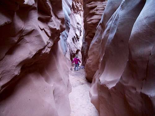
April 24: Little Wildhorse Canyon (Utah)
The original plan was to climb the west face of Mount Democrat, a Colorado 14er, but a storm and avalanche warnings put an end to that plan. Plan B was to take the kids down to the Rifle area for some hiking in the state park, but heavy rains put an end to plan B too. The weather forecast was good for the San Rafael Swell area of Utah, so Kessler, Shaylee and I headed over there.
After driving through a snowstorm the night before, we got up early in the morning and left Green River for Little Wildhorse Canyon under completely blue skies on a pretty warm morning. We started up the canyon, but weren’t sure if we could make it up a new obstacle that was rumored to be there. The canyon was a lot of fun and had a few fun climbing obstacles, but nothing serious. The rumored obstacle was easily passed and the kids had fun with it.
After getting through Little Wildhorse Canyon we headed west along the old 4wd track to the head of Bell Canyon which we descended back to the trailhead. Bell Canyon is another fun one with some minor obstacles. We completed the eight mile loop in seven hours including all the messing around time in the canyons. It was a great trip.
April 17: South Castor Ridge (Colorado)
The original plan was for an overnight campout in the Dinosaur area, but the rain put an end this so Kimberly, Shaylee, Kessler and I decided to climb some of the peaks along the South Castor Ridge in the Williams Fork Mountains, which is closer to home.
In the rain, we started up an old muddy and muddy jeep track, but once we reached the ridge it was pretty dry. The rain only lasted 20 minutes after we started the hike and then the weather was good. We climbed over one peak and were going to climb the next, but we ran into a fence and a private property sign high on the ridge. We turned back here and climbed back over the other peak and returned to the vehicle.
April 15: North Hogback (Colorado)
Since I got off work at a reasonable hour, I hiked up Twelvemile Creek south of Meeker, which is in what is known as the Grand Hogback. I followed an old 4wd road and then climbed a steep ridge on elk trails. The elk trails kept the bushwhacking to a minimum. At one point I turned around and saw a big cow elk sitting down in the bushes only 10 feet away. She was looking away from me and I was down wind. I wished I had brought the camera.
I followed the trail up to the ridgeline at which point there was quite a bit of snow in a few places. I headed north along the ridgeline over several false summits to the summit of Peak 7932. Peak 7932 is one of the highest peaks in the northern portion of the Grand Hogback. It had some great views of the surrounding country and especially the tilted landscape to the north.
April 11: Sand BM (Colorado)
Kessler, Shaylee, Kimberly and I made a quick climb of Sand BM. There was no snow and only a little mud, so spring is here. We ended up seeing several deer.
April 10: Signal Butte (Colorado)
Today Kessler, Shaylee, Kimberly and I climbed Signal Butte. We had other commitments in the afternoon, so we didn’t have time for a longer climb.
All of us had fun scrambling up the various cliff bands. As usual, the views from the summit and down the huge summit cliff were spectacular.
April 3: Pictograph Cave (Utah)
Not much happened today. We were all tired from the previous two days journeys and in the morning I took the group (Chris, Brett, Craig and Amanda) to see the Pictograph Cave in North Wash. It’s a short hike from Hog Springs, but is a very impressive place. We also visited some of the nearby petroglyphs panels before heading home. I also stopped for a short hike on the Rifle Arch Trail on the way back.
April 2: Marinus Canyon (Utah)
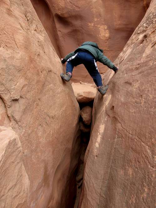
Marinus Canyon has been a sort of ongoing, but usually forgotten project for me. Fifteen years ago my wife and I explored up the canyon from North Wash until we reached a blocking falls. Around the same time period I made my way exploring through a maze of slickrock domes along the rim of Marinus Canyon. At the time I noticed that in one of the forks and from a certain section of the rim, it appears that the entire canyon goes through some tunnel or huge double arch. Finding a way into the canyon and to the arch has always sounded interesting, but the project was always put on the backburner for one reason or another.
By January 16 2010 (see trip log entry for that date) the project was near the front on my list. My brother and I made a respectable attempt to get in and through Marinus Canyon, but we were thwarted by snow, difficult conditions and lack of daylight. The trip was not a failure as it provided valuable route information to the rim of Marinus Canyon from the floor of Stair Canyon.
In late March I had posted online that I wanted to find partners to reach what I thought was a big arch in Marinus Canyon. Amanda, Craig, Brett and Chris offered to join me.
We got a later start in the morning due to our tiredness from the very late night before (see trip log for previous day).
The approach to the canyon went pretty smoothly (the route-finding my brother and I completed in January really helped out). Our approach went up Stair Canyon to a place where we could climb out to the rim. After that it was much routefinding, scrambling and some climbing. There were some short technical moves and some exposed scrambling, but it was a fun route and the views over the slickrock domes to the Henry Mountains were awe-inspiring. After reaching the floor of Marinus Canyon the going got easier for a while (though still a bit strenuous in places).
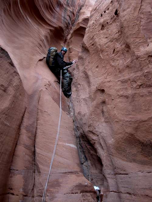
We slowly made our way down canyon to the top of a large pothole arch above a huge falls in the canyon. Right after the arch the canyon dropped into a HUGE keeper pothole (possibly the
biggest I have seen) hanging part way down (70-80 feet?) the drop (which was almost 200 feet high). Chris rappelled of a small falls and even a little off the lip of the big drop to get a good look directly into the By eye, he estimated it to be 30 feet deep, but that was just a guess. After that he came back up and we discussed what to do.
We quickly decided that with the relatively late hour we didn’t want to attempt the keeper pothole(especially since it was getting late) and discussed turning back. We also took a walk along a ledge to get a good look at the arch and pothole and subsequent drop. Several minutes later and during the discussion, I also noticed that if we traversed the wide ledge a bit down canyon and to a tree that there was a ledge part way down the drop that our ropes might reach and thus we could do the drop in two stages and thus avoid the keeper pothole.
I volunteered to walk the ledge over to the tree and see if the rope would reach the ledge (the others were sitting in a good place to view the drop). I walked over, checked out the tree (which was very solid) and threw the rope over the edge and after yelling my question across the canyon to the rest of the group (since they were in view of the ledge directly below me), found that it would reach the ledge for sure. We discussed what to do because the group was still divided on whether to turn back or just finish the canyon. I thought reversing the route or following the Kayenta (sandstone type) ledges out would take too long and we had already had a long day the day before (finishing the previous day’s canyon just before midnight) and that it would be much quicker to finish the canyon. Some of the others didn’t want to do anything technical in the dark (we had about 3 hours of daylight left) and thought we might not get through the technical section in the dark, though I expressed my feelings that I was pretty sure that there wouldn’t be any more big drops down canyon and that I would guess that there was a 90% chance that we could complete the technical section before dark since it wasn’t that far (~0.5 miles?) to where I had already hiked up from the bottom previously.
In the end we decided to push on and finish the canyon. The rappel from one ledge to the other turned out to be 170 feet. After completing the rappel, while the rest of the group was rappelling down I walked down to see if I could set up another rappel for the final 80 feet to the floor of the canyon. I found that could scramble to within 10 feet of the canyon floor and thought that with partner assist that we could downclimb the rest. I returned and told the others the news so as soon as we were all down the rap we headed down to the floor of the canyon. Other than at the big drop, we ghosted (left no trace) the other drops.
We found that there were several other obstacles in the canyon, mostly short. We had one chimney downclimb and another rappel. Another tricky and steep downclimb with a partner assist was used before reaching the part of the canyon that was “known”. Below that, it got dark and we completed getting through several boulder jams (it was a very dark night because there were no clouds) before reaching the lower section of the canyon. Below that it was a long walk out (or at least it seemed long) in the dark out to the vehicle. We were very hungry and tired but we had made it. We had got to see a new and impressive arch and visit a new section of canyon. Other than the fact that the canyon took longer than expected, it went off without a hitch.
April 1: North Fork Iron Wash (Utah)
The plan was to meet Chris, Brett, Craig and Amanda in Rifle Colorado at 10 am. Unfortunately, Chris and Brett were delayed by a wrong turn and a snowstorm, so we left late from Rifle.
On the way to Marinus Canyon (see next day’s entry) the plan (actually a last minute plan because we were running late and didn’t have enough time to do a longer route) was to do the North Fork Iron Wash, a technically challenging canyon in the San Rafael Swell in East Central Utah. We didn’t start the canyon until 4:30 pm, but I wasn’t that concerned since I have been there several times before and knew the area well.
From near the mouth of Ernie Canyon we made our way to and old 1920’s car that was converted into some kind of drilling rig, presumably for water. From there we made our way into the canyon, but since this canyon wasn’t originally part of the plan, we didn’t have a topo map and ended up hitting the canyon too far west. We explored one of the obscure upper forks to a huge spring and swimming hole before heading down canyon. The canyon quickly slotted up and we found that it was wetter than normal.
There was much clear (unusual) and cold water in the canyon and we found it to be more time consuming than it usually is. We explored many bypasses around the cold pools which required some very tricky technical climbing up to 5.9 in difficulty. One was a new keeper pothole that hadn’t been there before. We had a lot of fun cliff hanging on the technical bypasses above the pool until we got to the end of the slot section of the canyon, which is also the crux and the darkest part of the canyon (it is pretty dark in here throughout the day year round).
I have always taken a low route around the lower keeper pothole, but that route can be risky if you fell. Instead, we opted for the high route or “log route” as it is known. It is perhaps easier, but a little exposed in places. We climbed the exposed ledges up to the log and rapped down to the floor of the canyon just as it was getting dark.
Unfortunately, since it was dark, the return journey took much longer than normal (especially since we didn’t bring a topo map for this one). Routefinding wasn’t nearly as easy in the dark than it is in the daylight, but we were never lost. It was just slow going and we reached the vehicles not long before midnight. It was still an enjoyable day.
See the trip report for details:
North Fork Iron Wash and Marinus Canyon
March 27: Cedar Mountain (Colorado)
We were pretty busy during the day, but that was no excuse not to climb a mountain. Kessler and I decided on Cedar Mountain, but the route is somewhat sloppy or tricky at this time of year. Some of the sections have deep snow while some sections are bare of snow and other sections are muddy. If you take snowshoes you will be removing and putting them back on all the time. If you don’t, you can have some serious postholing in the snowy areas.
We decided to wait until after sunset to try the climb. The theory was that the snow and mud would be frozen enough that we wouldn’t need to bother with snowshoes. It was also nearly a full moon.
We started the climb in the twilight and used the moonlight to climb to the summit of the mountain. The lower 2/3 of the trail on the sunny side of the mountain, but we were on snow most of the rest of the way to the summit. At first it was indeed frozen, but in some places we would break through and sink up to our knees. We stopped to dump the snow out of Kessler’s boots (we didn’t bring gaiters) right after reaching some dry ground.
After reaching the summit we followed the ridge south and completed the medium length loop (there is a choice of three loops) before heading back to the trailhead. It was a mix of muddy, frozen, dry and snowy trail, but we didn’t sink as far in the snow on this section of the route. Along the way we heard some really weird animal noises; almost like a child screaming. I have no idea what kind of animal it was, but we looked for tracks. It definitely wasn’t human. It was a weird feeling. The rest of the loop was completed without incident.
March 25: Gold Star Canyon/Monument Mesa (Colorado)
Today after a class and after studying for a test I went to go up Gold Star Canyon to the rim of Monument Mesa. The reason I chose Gold Star Canyon is because it is the only canyon in Colorado National Monument that I hadn’t already hiked.
I hiked up the steep trail up into the mid section of Gold Star Canyon. After that I looked for the route up to the rim. I found and followed the obscure route up to Monument Mesa. I took several photos before heading back to the trailhead; arriving just before sunset.
March 21: Tsankawi (New Mexico)
It was chilly, but sunny in the morning near Santa Fe. There was some fresh snow around, but not too much so we drove north to the Tsankawi Ruins Trailhead in Bandelier National Monument.
We completed the loop hike around the ruins and petroglyphs while climbing over the top of the mesa in the process. The kids really enjoyed the wooden ladders leading up and over the cliffs. There was only a little snow on the trail and it was a great little hike to take before taking the long drive back to Craig Colorado.
March 20: Chihuahua Nature Trail (New Mexico)
This morning, Shaylee, Kessler, Kim and I awoke to strong winds and ……….snow! In Texas for spring break! It was windy all through the night as well so Kim and I didn’t get so much sleep. I had actually brought our four season tent and I was very glad I did because some of the other tents in the campground didn’t fare so well. The sky had cleared by morning and it was 24F degrees with an estimated 35-40 mph winds. We had planned to hike Devils Hall, but we didn’t bring enough clothing for near 0F wind chills so we packed up camp and headed back towards Carlsbad.
It was still cold and very windy at Carlsbad, so the only hiking we did was the Chihuahua Desert Nature Trail. Since we didn’t bring our heavy parkas, gloves and hats for this trip (we did bring coats) we decided to call it a day hiking wise. We actually ended up visiting the Alien Museum in Roswell before heading north to Santa Fe.
March 19: McKittrick Canyon (Texas)
Shaylee, Kessler, Kimberly and I awoke to high winds so we headed for McKittrick Canyon. We thought that the wind wouldn’t be as bad in the canyon since it is more heavily vegetated than the slopes of the mountains. McKittrick Canyon is also known as the most beautiful spot in Texas.
We hiked up the canyon, but it was really windy in the open areas. Even so the kids actually enjoyed being blown around by the wind and were quite amused by it. We stopped and checked out the historic Pratt Cabin before continuing up the trail to the Grotto which is sort of an above ground cave, complete with formations. After taking a very long lunch and relaxing, we headed back to the trailhead in strong winds.
March 18: Hunter Peak (Texas)
We (Shaylee, Kessler, Kim and I) awoke to perfect weather with only a light breeze and clear skies, so it was time to attempt to climb Hunter Peak which is said to have the best views in Texas. We chose to do the loop hike going up Bear Canyon and down the Tejas Trail. Bear Canyon has a nasty reputation as being very steep and difficult and we were a little concerned that it would be challenging for our five year old daughter. We found the trail to be fairly steep, but it wasn’t a problem at all and the rumors of it being difficult were mostly unfounded. It was a slow climb (at least slower than Guadalupe Peak), but we made it up to the summit of Hunter Peak without any problems. The peak did have some grand views and we took a long lunch on the summit.
We returned down the peak via the Bowl and Tejas Trails, but found that we had to cross a fair amount of snow on the rim of The Bowel. After reaching the Tejas Trail it was just a long walk back to the campground. Hunter Peak took us quite a bit longer to climb than Guadalupe did and we got back to camp not that long before sunset.
March 17: Guadalupe Peak (Texas)
There wasn’t much wind this morning, so it was time to climb Guadalupe Peak, the highest mountain in Texas! Shaylee, Kessler, Kimberly and I left in the morning and made our way steadily up the peak. About 2/3 of the way up there was quite a bit of snow and ice along the trail. The snowfields near the summit were the hardest part of the climb and I wished I had brought and ice axe or crampons for the peak in order to help the kids up.
After enjoying the summit and chatting with a few fellow climbers we headed down the mountain. All of us had a good time and it was great to climb the mountain in perfect weather.
March 16: El Capitan Trail (Texas)
Today was our first day in Guadalupe National Park, but it was really windy so Kessler, Shaylee, Kimberly and I decided to forego climbing any peaks. Instead we opted for the El Capitan Trail which follows a route from Pine Springs to the base of El Capitan rather than climbing it.
It was windy, but the wind wasn’t extreme so we made our way along the trail to Guadalupe Canyon while taking many photographs of El Capitan along the way. We then descended Guadalupe Canyon a short ways to where the trail climbed up to the base of the big cliffs of El Capitan. After eating lunch we returned to the trailhead. It was a great route even though we didn’t get to climb a peak.
Since there was still time available we also hiked the Pinery Trail before calling it a day.
March 15: Natural Entrance/Big Room (New Mexico)
Last night was stormy and very windy so we didn’t get much sleep in the tent. It was constantly raining which made it an excellent day to spend underground. We took a shuttle up to Carlsbad Caverns and then walked over to the Natural Entrance before dropping in. We dropped down, down, down into the depths of the cave, taking time to take photos and to look at all the formations. After walking all the way from the Natural Entrance to the bottom of the cave, we took the loop route around the big room which is the biggest underground “room” known in North America.
By the time we exited the cave, it was still raining hard. Hiking underground is the way to go on a cold and rainy day!
March 14: Kings Palace/Rattlesnake Canyon (New Mexico)
Today we had a reservation at Carlsbad Caverns for a tour of the King’s Palace. The original plan was to visit the rest of the cave after the King’s Palace, but when we saw the weather forecast we decided to save the rest of the cave for the next day.
The walk through King’s Palace was a good one with lots of fantastic formations, but Kessler missed the wild caves that he is more used to exploring. It was still a fantastic experience.
After walking through the King’s Palace with the ranger we returned to the surface and drove over to Rattlesnake Canyon. We didn’t start our hike until 2:15 PM, but I thought that the kids, wife and I could complete the six mile loop in time to be out of the park by 6:00 PM when the NPS locks the gate. Dropping down into Rattlesnake Canyon was easy, but going up Rattlesnake Canyon to the Guadalupe Ridge was more rugged and slower than I expected. By the time we made it to the Guadalupe Ridge it was obvious that we wouldn’t make it out of the park before the gate was locked. We hurried down the Guadalupe Ridge, but stopped briefly to view two javelinas which were next to the trail. They were just standing there at first, but by the time I got my camera out they skittered away.
We ended up at the NPS gate about 20 minutes after it was locked. I was just going to leave the vehicle there and walk to the campground and pick up the vehicle the next day, but someone else was also locked in and they called the rangers to come and let us out.
March 13: Alcove House [Ceremonial Cave]/Upper Lower Falls [Frijoles Canyon] (New Mexico)
Today Shaylee, Kessler, Kimberly and I stopped at Bandelier National Monument on our way to Carlsbad Caverns. First we hiked the loop to the Ceremonial Cave/Alcove House in Frijoles Canyon. The cliffs of Frijoles Canyon are pock marked with many caves that were used by the ancestral pueblo Indians hundreds (to thousands) of years ago. The kids liked climbing into the caves, but their favorite part was climbing up the long wooden ladders to reach the caves.
In the afternoon we still had time, so we hiked to the waterfalls in lower Frijoles Canyon. It was a great hike and necessary since we had a long car drive ahead of us.
See the trip report for details:
Bandelier National NM, Guadalupe NP and Carlsbad NP
March 8: Yampa River Trail (Colorado)
I took another routine hike along the Yampa River Trail on a chilly and windy day.
March 6: Hahns Peak (Colorado)
Austin and Kelsey Gilbert and I climbed Hahns Peak today. There was a snowstorm the day before, but today had pretty good weather with occasional mist and variable sunny, partly cloudy and cloudy skies.
We got a fairly late start up the mountain and work slow and steady while taking turns to break trail (two skiers were on the mountain as well so we had some tracks to follow) up to timberline. Because the peak was encased in mist much of the time preceding us summiting, there was some interesting hoarfrost on the trees. We made our way to the ice encrusted summit cabin before enjoying a late lunch while meeting the other two skiers on the mountain.
After lunch we headed back down the mountain while the skies got cloudier. It snowed very lightly, but for the most part, the weather was great and much warmer than average, though it was a bit windy and chilly on the summit. It was a great climb.
March 4: Yampa River Trail (Colorado)
I hiked a section of the Yampa on a warm day. The snow was wet and messy.
March 1: Yampa River Trail (Colorado)
Today I took another routine snow hike on the Yampa River Trail. It was a warm (by Craig standards) and sunny day.
February 27-28: Boreas Pass (Colorado)
February 27
Kessler and I had this weekend saved for a trip up to the Section House Cabin up on Boreas Pass (11,490 feet/3502 meters). Kessler was excited because the cabin is supposedly haunted.
The section house is perched right on the Continental Divide and was built in 1882 as a railroad stop for the railroad between the mines of Leadville and Georgetown. It has been fixed up so that modern day skiers and snowshoers can use it. The minimum distance of any route to the hut is 6.5 miles/10.5 kms each way.
In the morning we started up the trail in good, but cloudy weather. It was a slow, but uneventful snowshoe up to the hut. Along the way we met two other climbers whom accompanied us the rest of the way to the hut.
There were other people staying in the cabin as well. Kessler played twister with some of the other group and we told ghost stories before going to be.
At night, Kessler heard ghostly creaking around the cabin, but I slept OK.
February 28
Kessler and I debated rather to try and climb a peak or not in the morning. Kessler decided he would rather head back down the mountain and the weather appeared to be deteriorating anyway. The weather started out good, but slowly deteriorated as we descended. At one point we heard some loud thunder.
The weather deteriorated to near blizzard conditions at times, but we made our way down the mountain without any problems. It was a nice trip.
See the trip album for details:
Boreas Pass/Section House
February 26: Yampa River State Park (Colorado)
Kessler’s 2nd grade class was going to Yampa River State Park (near Hayden Colorado) to snowshoe and was asking for volunteers, so naturally I said I could go. The kids learned about cold weather safety and animal habitats before donning snowshoes and setting out into the forest. We did a loop hike through the state park and stopped several times to rest and to look at animal tracks before returning for civilization.
February 25: Yampa River Trail (Colorado)
Today I snowshoed a section of the Yampa River Trail in good weather.
February 15: Quail Creek Gorge (Utah)
Today the kids wanted to head back to Quail Creek in order to show it to my brother, dad and their cousin. We headed up Water Canyon to the waterfalls and once again to the rope climb and moki steps. Kessler, my dad and I climbed past the rope and climbed up to the inner rim of the canyon before heading back to the rest of the group. It was a nice four day trip, but was all too short.
February 14: Cinder Cone/Snow Canyon (Utah)
Today my Dad, my brother Mark and his son Josh again joined Kessler, Kimberly, Shaylee and I and headed to the Snow Canyon area. First we climbed the cinder cone and admired the views down into Snow Canyon. We then returned to the vehicle and drove into Snow Canyon itself.
After reaching Snow Canyon, we hiked the Butterfly Trail to the Lava Flow Overlook Trail and found some lava tubes to explore. We explored two of the lava tube passages that shared a common mouth. Kessler, Mark and I made it the most far with some crawling through a tight chamber to where it opened up into a bigger passage.
After exploring the lava tube we climbed up to a dome and enjoyed the views. We then headed down to the bottom of Snow Canyon and followed West Canyon Trail to where we climbed some high domes before looping back to the trailhead.
After completing our long loop trip we headed for the rather short Jennys Canyon to explore it. It was a short canyon, but the kids had fun. After the canyon we headed for the Sand Dunes and mostly just messed around until it was time to head back for camp.
February 13: Huber Wash/Petrified Forest/Chinle Trail (Utah)
Today my Dad, my brother Mark and his son Josh joined Kessler, Kimberly, Shaylee and I for the Huber Wash/Petrified Forest Loop in Zion National Park. The high country of Zion was buried in snow, but without snowshoes and skis, the low land routes are still very doable all through the winter.
Huber Wash has a fair amount of mud in it, but we made our way upcanyon before eating lunch not far below the Petrified Logjam. After lunch we hiked up to the Petrified Logjam where petrified logs stick straight out of the cliff face. After admiring the petrified logjam, we climbed up the canyon wall opposite the jam and found the class 3 chimney leading up to the rim. The kids enjoyed the tight chimney and perhaps had an easier time of it than some of the adults did.
After climbing the chimney we made our way over to the Chinle/Petrified Forest Trail and followed the trail all the way down to the highway. Kessler and I walked back towards the vehicle, but got a ride part way from passing motorist. It was a great hike on a beautiful day.
February 12: Quail Creek/Anasazi Trail (Utah)
Today Kessler, Shaylee, Kimberly and I hiked up Quail Creek to explore the canyon. Quail Creek is a beautiful gorge with waterfalls, narrows and pools and is nice at any time of the year. We had some shallow wading and we took a harder class 3 route around the first waterfall, but the going was easy until hitting Pool Falls. There was a rope hanging down the wall which served as a handline to climb the moki steps, but we decided not to take Shaylee above the falls so she waited with Kimberly.
Kessler and I climbed the rope and falls and went up canyon to a long pool of water. We then climbed high on the east wall of the canyon and climbed to the rim to admire the fine views before returning back down to where Kimberly and Shaylee were waiting. It was then a routine walk out and to the vehicle.
After completing Quail Creek, we hiked the Anasazi Trail to some Anasazi Ruins on the hillside before heading back down to camp.
See also the trip report for details:
Quail Creek/Snow Canyon/Zion National Park
February 9: Roaring Creek (Colorado)
On my way back from Greely, I stopped at the Roaring Creek Trail along the Cache la Poudre River. The trail was snow covered, but the snow was hard and icy making it easy without snowshoes as long as I watched my footing. I hiked the trail past several small frozen waterfalls and into the hanging valley a ways before returning to the highway and heading for home.
February 6: Cedar Mountain (Colorado)
It was snowing hard today, so due to its easy road access and closeness to home, Cedar Mountain seemed like the obvious choice of a mountain to climb. Kessler also wanted to invite his friend Kayden along to climb the peak as well.
We snowshoed up the mountain to a bench near the top where we ate lunch and then climbed the highest peak before completing the short loop as opposed to the longer one that we usually take. It was snowing, but trailbreaking was relatively easy until the top section. The climb took longer than usual because Kessler and Kayden wanted to play along the way.
The weather started out very snowy, but the snow slowly tapered off to just a light snow as the loop was completed, though we never did get any views.
February 3: Yampa River Trail (Colorado)
Today I hiked another section of the Yampa River Trail in mild weather. It was easier than usual since the trail was packed down previously by a group of skiers.
January 29-30: Mount Princeton (Colorado)
Mount Princeton is one of Colorado’s “14ers”. Since I am working on climbing them all in the winter, I posted for partners on Summitpost and 14ers.com (I had also attempted the mountain on February 1-2 2008 with another group, but we turned back in bad weather and conditions). Knowing that it would be very difficult to climb the peak in a single push without the trail broken, I was hoping a few of us could make the trip into an overnighter and break trail to near timberline the previous day.
January 29
Joel, Kenneth and I met in Buena Vista at 10 am and drove to the trailhead and packed up. After meeting we discussed whether or not to take the tents. There is a stone cabin high on the slopes of Mount Princeton, but on the drive in it looked like the route to the cabin crossed an avalanche slope. We decided to play it safe and forget about the cabin and pack the tents with us. We also met a group of three other snowshoers that were headed for the radio towers partway up the mountain and this was good news since we wouldn’t have to break trail the entire way ourselves.
The hike up to the towers was relatively uneventful and we took our time. After the radio towers (the snow was all virgin beyond this point), we decided to push on to the base of the steep ridge before camping at 10,980 feet. The moon was incredibly bright at night and the whole mountain was lit up. It was almost tempting to leave and climb the peak on the very well lit and calm night.
January 30
It was a warm night (for the altitude) at 14F/-10C, but I didn’t sleep that well. Since the other two brought stoves, I left mine in the vehicle and since they kindly did the cooking of breakfast, I offered to leave a little earlier and to start breaking trail up the mountain. The standard summer route would have been much easier, but we plowed a more direct route up the thickly forested ridge to timberline since it avoided an avalanche slope.
Breaking trail was quite difficult and very strenuous. I made maybe 200 feet vertical before the others caught up with me. After that we took turns breaking trail, but everyone had it equally tough. It was by far the most difficult part of the climb. After ascending 400 feet, we met Steve and some others whom started up the mountain at 6 am. The worst of the trail breaking was done, but we were thankful to have some more people to push the route up to timberline.
When we re-crossed the summer route, Steve continued straight up the mountain and the rest of us decided to try and follow the summer route a ways. We found that the summer route crossed a potential avalanche slope so we backtracked and followed Steve’s broken trail up the mountain. We all took a rest at the ridgeline above 12,000 feet and above timberline. Others climbers joined us along the way. We all ditched our snowshoes.
We discussed climbing the ridge directly over Tigger Peak, but it appeared that the north facing traverse below Tigger Peak might be in OK condition and would cut off some elevation gain. The traverse along the north facing slope was very slow and tedious and Steve pushed the rest of the route. The route was relatively safe and in condition on this day, but if any more snow falls on it, in one section, it could definitely slide after a fresh snowstorm. After the traverse we climbed directly up to the notch at 13,200 feet. There was lots of loose scree coated with powder snow (since the slope I north facing it hadn’t seen any melting so the scree was not frozen in place). It was a battle between hard (but slippery) rock and soft snow. More people joined us along the way and after the notch it was a strenuous but straightforward climb another 1000 feet to the summit.
By the time we were on the summit, there were 12 people in our group (all members of SP and 14ers.com), but one person had turned back early. It was late afternoon and it was obvious that we would not be back by dark, so we headed back down the mountain.
After reaching our snowshoes again we all headed off the mountain and the group was scattered into many small groups by then. Joel, Kenneth and I basically stayed together and stopped at camp to pack up. Joel decided that he might as well camp another night instead of spending the night in a hotel (he had flown in from Kentucky, so was far away from home), so I gave him the last of my leftover food and headed down with Kenneth. We shook hands with Joel and Kenneth and I hurried down the mountain in the dark (I packed my light away, but had plenty of light between Kenneth’s headlamp and the bright moon) and did the rest of the descent in an almost jogging pace and very quickly without ever stopping. I had hoped to catch up with some of the others to say goodbyes, but since we stopped to pack up camp, we just missed them. We got to the parking lot right when the other vehicles were leaving.
It was a good climb (for a choss pile at least) and we definitely earned the summit. The drive home was a long one.
See also the trip report:
Mount Princeton
January 27: Mount Morrison (Colorado)
This afternoon I climbed Mount Morrison from the east and above. I chose this route because I had already climbed the peak from the south several years ago. The trail was steep, but there was only a little ice on it. Denver was quite smoggy, so views weren’t good to the east, but there were some pretty good views west despite the clouds.
On the return, I took a different trail down, but when I got to the bottom there was a sign saying the trail was closed.
January 26: Green Mountain (Colorado)
I was in Denver for a couple days, so I had time to do a night hike while in the area. SP member Steven Cross joined me for a climb of Green Mountain. We left one car at the west end of the Green Mountain Trail and one car at a small trailhead off Alameda Avenue.
After figuring out which trailhead we were meeting at, we started climbing the mountain just after dark, but the moon was bright enough to hike without a flashlight or headlamp. We climbed to the summit of Green Mountain and saw all the city lights of Denver. After a break at the summit (where Steve took some night photos) we headed SE along the ridge over the top of another summit and then followed the trail down to the Florida Trailhead on the east side of Green Mountain. Since the car was parked on Alameda Avenue, we hiked the Lonesome Trail through the lower slopes of the mountain and found the vehicle. It was a great hike on a clear night. It was cool (in the 20’s), but not bad for January.
January 24: Sand BM (Colorado)
I went on a scout camp the day before, so didn’t have time to climb anything big this weekend. I climbed Sand BM at night. The moon was so bright that I didn’t need a headlamp and breaking trail was easy since the snow was pretty firm.
January 21: Yampa River Trail (Colorado)
I hiked another section of the Yampa River Trail.
January 19: Yampa River Trail (Colorado)
Today I hiked a section of the Yampa River Trail in the snow.
January 18: Lucky Charms (Utah)
Today Kessler, Richard, my Dad and I were headed back home so we needed a shorter route to do. Kessler still wanted something challenging, so we decided on Lucky Charms Canyon in upper North Wash. There was some very light snow falling in the morning, but the weather wasn’t that bad.
All of us walked up the canyon to find some snow, but little ice covering the canyon walls which made for good conditions. The canyon becomes more challenging as you head up canyon. My dad stopped at the first short 5th class climb, while Kessler, Richard and me continued up to the head of the canyon. There were several obstacles to get around and Kessler enjoyed the stemming. After reaching the head of the canyon, we headed back down the canyon and then headed home.
January 17: Death Canyon and Turkey Knob (Utah)
After yesterday we were about weary of conditions in the technical canyons, but Kessler still wanted to do one. Members of the group were Kessler, Richard, Dad and I. We decided on the ominously named Death Canyon since the technical section is pretty short so we would be able to check it out easily before descending the most difficult section.
We hiked up Death Canyon to the falls, finding a fair amount of snow, but pretty easy conditions. We climbed up a low 5th class route on the west side of the canyon. Kessler and my Dad were belayed while Richard and I climbed rope-less. We walked around the west side of the canyon until we found a climbing route down in. Kessler was lowered by rope into the canyon and my Dad was belayed while Richard and I climbed down free.
After dropping into the canyon, we explored downcanyon. We got to the technical section and set up the ropes. Richard went down first, but Kessler began to get nervous about rappelling off the drop. I lowered him off the first drop and we went downcanyon to the next rappel. This one was into a shallow pool of water and Kessler was nervous about this one too, but the survived. Everyone except Kessler got wet, but it was a fairly nice day-for January.
After eating lunch, we found a climbing route to the east wall of the canyon. All of us headed towards Turkey Knob, but Richard stopped once we reached the ridge since his ankle hurt from a minor fall yesterday.
Kessler, Dad and I struggled our way towards Turkey Knob. In some places there was a fair amount of snow, in other places there was a bit of loose scree and sand, but overall it wasn’t too difficult, though it was strenuous. We reached a sub-peak before finding ourselves on an exposed knife-edged ridge.
Kessler and Dad stayed put while I tried to find a route to the summit. I traversed over to the north side and found a loose chimney allowing access to the base of the summit block which I also climbed quickly. I found a better route down via a steep and dirty gully, but the route was suitable for Dad and Kessler so I went back and got them.
Kessler and I made it to the summit of Turkey Knob while my Dad stopped 10 feet short of the summit due to some exposure. We found some incredible views from the top on a clear day. It was a climb well worth taking.
January 16: Stair Canyon, Marinus Knobs and Bailout Canyons (Utah)
Richard and I planned to hike up Stair Canyon to the head of navigation, climb over the steep and high ridge over the Marinus Domes and to descend Stair Canyon. Dad and Kessler were to hike up Stair Canyon with us and return the same way.
Right off the bat, there was quite a bit of snow in Stair Canyon which slowed us down quite a bit. It took the four of us quite a while to hike to the head of navigation in Stair Canyon. Somewhere along the way, Richard had a handhold break off and suffered a minor ankle injury.
Once we reached the head of navigation in Stair Canyon, Kessler and my Dad parted ways with Richard and me. Richard and I found a steep and difficult route up to the rim of Stair Canyon. If dry, it wouldn’t have been that difficult, but this time it was covered with snow and ice. All the ledges and the many boulders had a thin layer of ice under the crusty snow. We struggled for hours across treacherous ledges and rocks just to reach the dome-lands between Stair and Marinus Canyons before finally finding ourselves on a steep dome with no route down the other side. We took a rest and talked about the next course of action. Looking at the watch we only had 2.5 hours of daylight left and we were still not even in Marinus Canyon.
Though disappointed, both of us decided to bail and save Marinus for another trip. We decided to descend a SW Fork of Stair Canyon to reach the vehicle where Kessler and Dad were on the way too. We knew the canyon was technical since I had been to the bottom of the falls on another trip, but it didn’t look too difficult. After the initial difficult route in, the upper ¾ of the canyon was a wide and easy canyon (other than 6-8” of snow in much of it) before the canyon dropped into a technical slot. The slot had some slippery ice and the walls, but we went through it without too much difficulty. After the technical slot, we headed down canyon and found the final drop into Stair Canyon to be 7-8 feet or so. Even so, we had to set up a rappel since the drop was icy and we couldn’t bypass it. After the drop it was just a routine walk out and we met Kessler and my Dad right as it was getting dark.
It was a cold and gloomy day, with little sun. It was a challenging trip and we were not successful, but we will be back when conditions are better!
January 15: Sandpipe Butte and un-named buttes (Utah)
Today was our first in a four day adventure. Kessler and I were originally planning to explore the area around the Gilson Buttes, but there was 6-12” of snow there so we headed farther south towards Hanksville where there wasn’t as much snow.
In the area of Hanksville there are many interesting buttes. We decided to see how many we could find routes up. We explored around two buttes and found them to be too difficult. We explored around Sandpipe Butte to where we thought there might be a route up. We climbed up the steep sand and talus which was mostly covered with snow, to a promising looking crack in the caprock. After climbing to the crack, it was obvious that it wouldn’t be that easy. The pitch was 5.7 feet in difficulty. I climbed the pitch first and had a good look around before climbing back down. I lifted Kessler up the first six feet and he climbed the rest of the 25 foot pitch to the top to where I soon followed. After reaching the top we spent several hours exploring around before heading back down an easier, but snowy route. We climbed a few other highpoints before it was getting dark after which we headed for Hanksville.
See also the trip report:
Sandpipe Butte/Stair Canyon/Marinus Knobs/Bailout Canyon/Death Canyon/Turkey Knob/Lucky Charms
January 12: Yampa River Trail (Colorado)
Today was another hike along the Yampa River Trail on another cold day.
January 11: Yampa River Trail (Colorado)
Today I hiked a section of the Yampa River Trail in the snow. The snow was packed down by cross country skiers, but it was a very cold day and well below zero when the hike was done.
January 2: Casa de Campo (Spain)
Shaylee and I were in Madrid for a two day lay-over and after seeing all the normal city attractions, we headed over to the Casa de Campo. We rode the Teleférico into the center of the Casa de Campo where Shaylee played on the playground after which we hiked several of the nearby hiking trails, making a loop. It was a cloudy day, but it wasn’t near as cold as it was back home.
Accumulated Totals for 2010:
Days that I went hiking or climbing: 120
Summits Climbed: 72
Summits Attempted: 78
Rock Towers: 0
Rock Towers Attempted: 0
Technical Canyons: 5
Technical Canyons Attempted: 5
Overseas Climbs: 8
Goals for 2010:
Days spent hiking or climbing: 100
Summits: 75
Summits with the kids: As many as possible!
Rock Towers: 5
Technical Canyons: 20
Highest Elevation Reached
14,205 (4330 meters) on Mount Princeton (Colorado); January 30.
Highest Elevation Reached in USA
14,205 (4330 meters) on Mount Princeton (Colorado); January 30.
Highest Sleeping Altitude
11,640 feet (3548 meters) on Capitol Lake (Colorado); September 4-5.
Highest Sleeping Altitude in USA
11,640 feet (3548 meters) on Capitol Lake (Colorado); September 4-5.
Highest Elevation Climbed To By Month
| Month | Feet | Meters |
| JAN | 14,205 | 4330 |
| FEB | 11,490 | 3502 |
| MAR | 10,839 | 3304 |
| APR | 7932 | 2418 |
| MAY | 13,820 | 4212 |
| JUN | 10,100 | 3079 |
| JUL | 13,434 | 4095 |
| AUG | 14,179 | 4322 |
| SEP | 14,152 | 4314 |
| OCT | 10,403 | 3171 |
| NOV | 11,842 | 3609 |
| DEC | 6300 | 1920 |
Highest Outdoors Sleeping Altitude by Month
| Month | Feet | Meters |
| JAN | 10,980 | 3347 |
| FEB | 11,490 | 3502 |
| MAR | 5800 | 1768 |
| APR | 4451 | 1357 |
| MAY | 4860 | 1481 |
| JUN | ||
| JUL | ||
| AUG | 9800 | 2987 |
| SEP | 11,640 | 3548 |
| OCT | ||
| NOV | 11,630 | 3545 |
| DEC | 4016 | 1224 |
January 30
Highest January ascent for Colorado; Mount Princeton at 14,205 feet (4330 meters). Previous January record was 14,115 feet (4302 meters) on Pikes Peak on January 1 2005.
March 17
Highest ascent in Texas; Guadalupe Peak at 8749 feet (2667 meters).
May 22
Highest May elevation reached; false summit of Mount Antero at 13,820 feet (3926 meters) [highest elevation reached-summit of Antero was not obtained]. Previous May record was 12,880 (4212 meters) on Capitol Peak [highest elevation reached-summit of Capitol was not obtained] on May 29 2005.
August 14
Highest August ascent; Mount Shasta at 14,179 feet (4322 meters). Previous August record was 13,309 feet (4057 meters) on James Peak on August 16 2003. This was also the highest ascent in California.
December 10
Highest ascent in Singapore; Southern Ridges at 312 feet (95 meters).
December 12
Highest ascent in Malaysia; Gunung Beremban at 5945 feet (1812 meters).
December 17
Highest ascent in Indonesia; Gunung Leasur at (approximately) 3609 feet (1100 meters).