Why Mummy's Tummy, Mt Charleston, and Griffith Peak?
3 reasons for these 3 peaks:
1) Hiking just Mt. Charleston is a good conditioning trip offering 20-degree cooler temps than the Valley, trail has a gradual rise over run, and a 30min drive outside Vegas.
2) But when combined with 2 other peaks shared on its range, it becomes a scenic ridgeline journey for the entire day. Climbing Mummy's Tummy (of Mummy Mountain) and Griffith Peak add good vistas, route finding, and both have survey markers and registers.
3) Logistics were favorable for inside a 12hour climb: 4miles to Mummy's Tummy with a 4000'elev gain, 5miles to Charleston with about a 1500' up/down gain, then about 4.5miles to Griffith on a fairly level ridgeline trail, and descending after that for about 4000'elev loss over say 4miles. And a wee 1mile road connection after that.
Actual Trip Schedule
-30min drive outside of Vegas
09:30 Started at N Loop trailhead
10:30 Made the first ridge saddle, good break spot, 1500' elev gain
11:00 Hiked by the last big water source of Cave Springs
11:30 Turned off N Loop Trail to ascend to base of Mummy
12:00 on the ridge heading to Mummy's Tummy
12:45 Summitted thru the second rock chasm to the top of Mummy's Tummy 11,500'
14:00 rejoined N Loop trail on ridge-line headed to Charleston
16:00 summitted Mt Charleston 11,900'
19:00 base of Griffith
19:12 summitted Griffith
19:30 descended via South Loop Trail
21:30 Start of the South Loop Trailhead 7500'
22:00 At the car after 1mile road connection
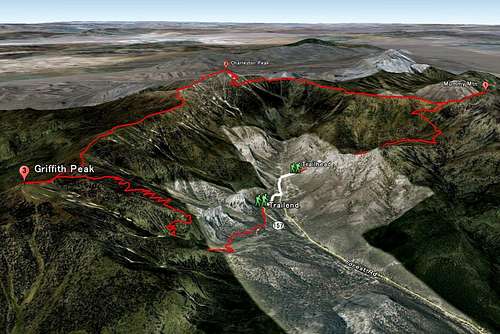
![3D of 3 Peaks in One Day]() 3D map of trail
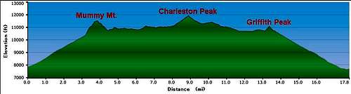
3D map of trail![Elev and Distance]() Elevation and distance
Elevation and distanceOther Trip-Related Links
1. Looking for a way to make this hike even more challenging? Climb up Devil's Thumb to Charleston - a good winter alternate. More info here:
Devil's Thumb Shortcut2. Here are more photos from a friend's trip, and also the source of the 3D mal photo and elevation/distance graph.
http://www.vegashikers.com/pic/20110715/p1.html3. Topo map of North Loop Trail to Mummy's Tummy:
http://hwstock.org/mumMay/html/mum.htm


Comments
Post a Comment