Craters Part II
Perhaps one of the best ways to visit Craters of the Moon National Monument is by snowshoe in the winter. Entrance is free and there's fewer people and more places to go.
Last winter Zach and I set out on a quest to climb as many of the named peaks within the monument as we could. In
our 2010 trip we were only able to get 3 of the 10 peaks we wanted and the trip had nearly ended in disaster when my snowshoe broke in the middle of nowhere.
This year, however, everything turned out perfectly and we were able to knock off 7 peaks within 7 miles and 6.5 hours.
![Our Route]() Our Route
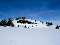
Our RouteSunset Cone 6,410 ft.
![Sunset Cone]() Sunset Cone
Sunset ConeAfter arriving at the Craters visitor center a little after 8:00 AM we set our sights on the second highest cone in the park, Sunset Cone. It lies immediately across highway 20 from park headquarters. The summit contains several radio towers and weather stations and is the only peak in the park that is developed in this way.
The snow this year was lower in quality than last years trip and was melted out on places. We still made good time and were at the summit in about 15 minutes. The view of the park to the South and the surrounding area was wonderful. After a few minutes we set our sights on the other named peak North of the highway, Grassy Cone.
![North Crater Aa Flow]() Nasty Aa
Nasty AaGrassy Cone 6,315 ft.
To reach Grassy Cone from Sunset Cone we had to either cross the North Crater Aa Flow or go around it. Seeing how much of a tangled mess the lava was we decided to go around. Luckily the flow stopped between the two cones and it was interesting to walk along the edge of the flow which towered 20-30 ft. above the surrounding terrain. Along the edge of the lave we went through a pocket of cold air and experienced the only truly cold moments of the day.
![The Lava s Edge]() High Lava
High Lava
Soon we were at the base of Grassy Cone's forested North slope. It was a steep hike to the top and the snow was sugary powder since the shade of the trees had kept it from melting significantly.
Once at the top there was some question as to where the actual highpoint was. We decided to hit both likely points before heading back South across the highway to our next objective, Silent Cone.
Silent Cone 6,357 ft.
Getting to Silent Cone from Grassy Cone looked to be an interesting challenge as we were required to cross part of the Blue Dragon flow to get there. Looking at this mess of sharp rock in the summer makes it look very intimidating, but thankfully we found that the snow cover made it quite easy and we made very good time. The North slope of Silent Cone was steep at first and mellowed out near the top and we made it in about an hour. Here we decided to stop and have some lunch. The hardest part of the trip was over and we were starting to come back to the main part of the monument where more people frequented the trails. (We were, however, off-trail pretty much the entire day.)
![Tracks Down Silent Cone]() Silent Cone
Silent Cone"Breathing Holes"
It was here in the Silent Cone area that we also began to discover an interesting obstacle that would be a recurring theme throughout the day. Occasionally we would find a hole in the snow and when we looked into one we would find a large open space below the surface, detached from the rock. It was almost like there was a system of snow caves hidden below the surface. Usually they were strong enough to support our weight but occasionally we would fall into one. There was only one truly "enlightening" experience when I sunk into one and upon looking down discovered that the only thing keeping me from falling into a fairly deep crack was my snowshoe. It was just long enough to bridge the gap between two rocks and keep me from sinking up to my neck.
Later a park geologist explained that the holes were due to the earth "breathing" or "venting" in those areas. It is a volcanic monument and we hadn't realized that there was still enough activity to generate this phenomena. They weren't really gas vents but the air escaping was just warm enough to melt the snow from underneath and create these snow caves.
"Big Craters" Peak 6,295 ft.
![Big Craters]() Big Craters
Big CratersThe descent off of Silent Cone was fun in the soft snow and lasted about 10 minutes. Our next objective was a bonus. The unnamed peak near the Big Craters. We hadn't considered climbing this but we we arrived we realized it was on our route and was actually quite prominent. It turned out to be one of the highlights of the day as it was quite alpine-like in appearance. It had a precipitous North face and a narrow-ish ridge walk to the summit overlooking multiple giant craters. It was my favorite peak of the day.
On the summit of this peak we saw the first people we had seen all day. They were below us on the groomed park road which crosses over the saddle between "Big Crater" and Inferno Cone, our next peak.
Inferno Cone 6,181 ft.
Inferno Cone is really quite a lame peak but it is probably the most climbed "peak" in Idaho. There is a trail to the top and it only takes about 5 minutes to get to the summit. At the bottom we joked around and made fun of the park service sign warning of the presence of rocks 4 inches in diameter.(Oh no! Scary! I think I just saw one over there!) We were at the summit 5 minutes later and took some more of the cliche Craters shots of the lone tree at the top with Big Southern Butte in the background.
As lame as the peak is, it was a record breaker for me. My previous record for peaks in one day was four and this was my fifth. Better yet we still had two to go!
![Inferno Cone]() Inferno Cone
Inferno ConePaisley Cone 6,107 ft.
![Paisley Cone]() Paisley Cone
Paisley ConeWe were surprised to find that no one had descended the open East slope of Inferno and found that the snow was really fun to plunge step into.
We had to cross the groomed park road to make it up Paisley which is, although lower in elevation than Inferno, more prominent.
The day had been sunny and pleasant all day but it was here that the temperature became quite miserable. It was probably on the low 40s which is quite warm for the area at this time of year and I was dressed for colder weather. (When I got home I found out it had reached 61 degrees in Boise!)To avoid drowning in my own sweat I shed every layer I could once I reached the summit and was comfortable for the rest of the day.
Our next peak was our final objective of the day, North Crater.
North Crater 6,244 ft.
North Crater is probably the most popular winter peak in the monument since it is the closest one to the visitors center and has a large open face that is popular for skiers and boarders.
We found the snow between Paisley and North Crater to be very solid and made excellent time to the top of our final peak. Once there we celebrated our 7 peak, 7 mile day, took our summit shots and descended down the soft snow on the Northeast slope. After crossing one last lava field we were back at the visitors center exactly 6.5 hours after we started.
![Zach on North Crater]() Climbing North Crater
Climbing North Crater
We were back home in Boise in time for dinner with 7 winter ascents under our belt. Of course I realize that these are not major peaks but they are all named or have 300 ft. of prominence so they can technically count as peaks, at least in my book. However you look at it though it was an awesome day in an awesome place and a perfect winter outing.
Links
Our GPS data from the trip
Idaho Outdoors Forum
Zach's Blog![Blizzard Mountain]() Blizzard Mountain
Blizzard Mountain


Comments
Post a Comment