Something Amiss
We have all experienced moments when we thought the map was incorrect in some aspect. Today climbing in glaciated alpine ranges, often a map is incorrect necessitated by the retreat of a glacier. I remember my first experience climbing through the fog of a mountain whiteout to aptly named Pea Soup Gap on Mount Daniels. Peering through this gap we expected to find a glacier filling a basin, not the beautiful but uncrossable jade colored lake, pictured above right. Today ascending in a glaciated range you may encounter a new alpine lake formed where your map shows ice. An easy route up a glacier may be replaced by impossibly steep, smoothed slabs. A gentle glacier slope in the valley bottom, may now feature a steep canyon with a difficult to surmount waterfall. The classic guidebook route description no longer is accurate. Changes in these areas are outpacing our slow paper remapping process. Below are a few examples of changes not reflected on maps of the North Cascades and a sample from other regions. I hope you will help me expand the latter sections with further examples.
North Cascades
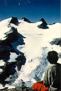
![Lynch Glacier 1975]() Lynch Glacier in 1975 filling the Pea Soup lake Basin providing easy access to Mount Daniels upper slopes.
Lynch Glacier in 1975 filling the Pea Soup lake Basin providing easy access to Mount Daniels upper slopes.Mount Daniels: The Lynch Glacier route as described by Fred Beckey entails an easy hike through Lynch Gap onto the glacier and ascending the 25-30 degree glacier slope.
However, in 1976 the terminus of the glacier which spread out across a flat basin, with some evident water shown on the map, much like a moat around the edge of the glacier, began to break up. By 1978 the breakup was complete and Pea Soup Lake was born, albeit filled with large ice bergs. Passing through Lynch Gap you were now confronted by a 400 m wide deep alpine lake with cliffs along both shores to your left and right. Since 1985 the lake has turned from a pea green to a jade color as the glacier flour has been diluted. The lake still does not exist on the Mount Daniels Quadrangle. I have accessed the base of the glacier by a small raft, but unless the lake is ice covered there is no other practical means of reaching it. This is a small glacier that calves small ice chunks occassionally. This happened during our crossing giving us a good rocking in our little raft.
![Lynch Glacier 1999]() Lynch Glacier in 1999 no longer reaching the new Pea Soup Lake and providing a barrier to Mount Daniels upper slopes.
Lynch Glacier in 1999 no longer reaching the new Pea Soup Lake and providing a barrier to Mount Daniels upper slopes.
Whitechuck Glacier:
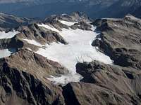
![Whtichuck Glacier 1988]() White Chuck Glacier in 1988. On the right side of the glacier is the segment leading up to Glacier Gap.
White Chuck Glacier in 1988. On the right side of the glacier is the segment leading up to Glacier Gap.A standard climbing route on the south side of Glacier Peak was to ascend the north arm of White Chuck Glacier to Glacier Gap. This one mile hike up a gently sloping glacier, free of crevasses was a mindless stroll on a comparative sidewalk in 1984 when I first ascended it. By 1995 the ice had lost its glacier blue color and was grayish and clearly thinning rapidly, yet it was still an easy ascent that on bare ice could be done without crampons if care was taken. In 2002 the north arm of the glacier was gone. Three new alpine lakes, only one of any size filled the valley. The lowest and largest of the lakes had a maximum depth of 15 meters in 2002. The hike to Glacier Gap included not a single step on a glacier. The hike took much longer as now you had to pick your way through loose boulders and talus that gave more than they took. Going downslope at the end of a long climbing day instead of a mixed glissade and saunter down easy no is a prolonged slog. The south branch of the Glacier is still surviving and with evident crevassing has some life to it.
![Whitechuck Glacier]() White Chuck Glacier in 2005. On the right side where the glacier used to be is a bare valley with new alpine lakes.
White Chuck Glacier in 2005. On the right side where the glacier used to be is a bare valley with new alpine lakes.
Mount Formidable: On the north side of Formidable is the Formidable Glacier which in 1980 flowed down to meet the Middle Cascade Glacier. This provided an access to the mountains north slopes. Today the Formidable and Middle Cascade Glacier have jointly shrunk to the point that 300 m of very steep, smooth, talus filling every crack, slabs separating the two. I have found on a number of occasions that the retreat up the sidewall of a glacier tongue provides the slope at the base an uncomfortable bombardment of rocks. This many of you have experienced I am sure.
White River Glacier:
![White River Glacier]() White River Glacier in 1988. The two termini fill basins, with just a hint of water.
White River Glacier in 1988. The two termini fill basins, with just a hint of water. This glacier ended in two flat basins providing easy access to the upper glacier and Kololo Peaks. The two basins are now open lakes, with steeper ice spilling down to end at the edge of the lakes. The access to the glacier is still easy, and these new alpine lakes are quite pretty. It took three years for the first waterfowl to find the eastermost lake. The lakes are generally snow-ice covered until the start of August.
![White River Glacier 2004]() White River Glacier in 2005. Two new lakes now fill the basins at the end of the glacier.
White River Glacier in 2005. Two new lakes now fill the basins at the end of the glacier.
Honeycomb Glacier
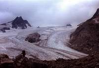
![Honeycomb Glacier 1977]() Honeycomb Glacier in 1977 note prominent Nunatak, still fairly small.
Honeycomb Glacier in 1977 note prominent Nunatak, still fairly small. in 1940 provided a smooth three mile long ramp of ice to the Kololo Peaks. By 1950 a small nunatak had begun to protrude through the ice. By 1977 the Nunatak had become substantial. In 2002 the Glacier barely reached past the Nunatak and a new lake had formed at the terminus. The 300 m wide lake, is shallow and currently very cloudy with glacier flour.
![Honeycomb Glacier 2003]() Honeycomb Glacier in 2002 note prominent Nunatak, now quite a rock face.
Honeycomb Glacier in 2002 note prominent Nunatak, now quite a rock face.The Nunatak in 2005 is at the end of the glacier, representing a 700 m retreat since 1967. The former Nunatak is now a 120 m high rock face separating the two terminus tongues. Honeycomb Glacier is still a long large glacier for the North Cascades and will be around for a long time.
![Honeycomb Glacier 2005]() Honeycomb Glacier in 2005, with new alpine lake and gigantic rock knob, formerly the Nunatak.
Honeycomb Glacier in 2005, with new alpine lake and gigantic rock knob, formerly the Nunatak.
Mount Hinman: In the Beckey guide Hinman Glacier is noted as the largest glacier between Rainier and Glacier Peak. On the map it is a gently sloping 1.4 mile long glacier on the northwest slope of Mount Hinman. In reality a skinny lake fills the former terminus area with steep slopes on either side. You can ascend the entire former length of the glacier near its center without touching ice. Only two small glacier fragments remain. The approach up the valley is not practical except when the lake is ice covered. The Alpine Lakes Wilderness has gained a new lake along with Pea Soup Lake. On the northeast face of Mount Hinman is Foss Glacier. This glacier covered almost the entire face of the mountain 30 years ago. Today the peak is beginning to resemble a Sierra Nevada Mountain, lots of bare rock and some snow and ice patches.
![Foss Glacier]() Foss Glacier used to dominate the Northeast slope of Mount Hinman, but no more.
Foss Glacier used to dominate the Northeast slope of Mount Hinman, but no more.Other Regions
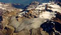
![Perdido 1998]() Peridido Glacier in 1998 has retreated above the cliff band.
Peridido Glacier in 1998 has retreated above the cliff band.![Perdido 1910]() Peridido Glacier in 1910 provides an ice ramp past the cliff band.
Peridido Glacier in 1910 provides an ice ramp past the cliff band.Other Regions:
Pyrenees: Monte Perdido north side in 1910 featured a steep glacier climb. In fact you could ascend from the valley to the ridgeline almost entirely on glacier. The 1998 picture taken by Eduardo Blanchard shows a steep 55 degree 300 m cliff band exposed by the retreating ice. For those who like to stay off ice a route improvement.
Rhone Glacier has experienced a substantial retreat since 1850, retreating from the community of Gletsch more than 2 km. In the last decade a tributary feeding the Rhone Glacier in the center flowing in from the right has detached from The Rhone Glacier. This makes the climb that much more difficult. The image is provided by David Collins Unversity fo Salford.
![rhone glacier]() Rhone Glacier with a tributary separating from it.
Rhone Glacier with a tributary separating from it.
Olympics: Anderson Glacier: The ascent of this glacier and the crossing of Flypaper Pass to reach the Eel Glacier used to be a relatively shore steep ascent. With the thinning of both glaciers the steep rubble filled chute on both side of this pass is not considerably longer. This same phenomenon is evident at the head of other retreating glaciers such as at Cache Col in the North Cascades.
Canadian Rockies:
![Yoho Glacier]() Yoho Glacier in 2003 no longer dominates the horizon.
Yoho Glacier in 2003 no longer dominates the horizon. Yoho Glacier. This glaciers thinning and retreat has left a vast wasteland of bare terrain, dotted by several new alpine lakes. The gentle slope of the glacier suggests that this will continue. The glacier has retreated 2.1 km in the last century. The retreat will continue to reduce late summer streamflow in the Yoho Rivre due to the smaller glacier available to melt.
Now it is your turn to provide examples, with evidentiary pictures and I will add them to this article.


Comments
Post a Comment