Why Orizaba?
The draw of high-altitude mountaineering is not easily explained to the uninitiated. The struggle through thin air, the cold weather, loss of appetite, altitude sickness, absurdly early wake-ups and negotiating third-world transportation systems and dangerous climbing… it just doesn’t have much appeal for most folks.
For the aspiring mountaineer who enjoys the above described suffering however, Colorado’s varied terrain offers many possibilities.
One thing that you are limited by in Colorado though, is elevation. Although the state has the highest mean elevation of all 50, its highest point is Mt. Elbert. At 14,433’, Mt. Elbert is as high as you can get in Colorado –without taking flight that is.
For many mountaineers this 14,433 foot roof can sometimes feel limiting, leading them to expand their search to get higher beyond the state. Often this search leads to the highest peak in Mexico, El Pico de Orizaba.
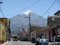
Orizaba, known as Citlaltepetl, or “Star Mountain” to locals, rises 10,000’ above the plains that surround it to a height of 18,400-18,700’, depending who you ask.
Despite some disagreements over its official height, Orizaba is without question higher than you can get in the continental United States. This extreme altitude makes an otherwise technically easy climb a more serious undertaking.
Whether someone has climbed a mountain before or not, a trip to Mexico to climb Orizaba is within reach for the motivated adventurer.
A climb of Orizaba doesn’t just take someone to the top of the Mexico; it takes them through it as well, exposing a timeless agrarian culture that few tourists see.
“Getting there is a cultural experience,” said Ian MacDonald, who has summited Orizaba twice, once in 1993 and once in 2006.
There are a few major considerations before undertaking a trip like this.
Many people, especially those who have never climbed a mountain before, might consider hiring a guide. Going guided will greatly increase the odds of having a safe and successful trip, although for some it simply isn’t necessary.
“Our experience wouldn't have been half as satisfying if we had gone with a guide,” said Ben Conners, who summited in 2007. “On Orizaba I don't really see what a guide would contribute other than being able to tell you to turn around if he thinks you should.”
Others might find value in a guide and choose to use one, for those that do thinking local is a proven method for saving money. Not only will they generally be less expensive, local guides are more likely to be experienced with the local culture, customs and the mountain.
Many American companies simply partner with a local guide anyway and then charge much more than going through them directly.
Most local options for guides and logistics are located at the base of Orizaba in the small, serene town of Tlachichuca.
Servimont, is a local climber’s hostel that has been run for three generations by the Reyes family. They are one option for a guide, transportation, or, “anything you need on the mountain,” if you ask Gerardo Reyes, who runs Servimont with his brother Luis.
“Nobody knows the mountain like we do,” Gerardo told me on one visit.
With family summits of Orizaba dating all the way back to 1935, history backs up his claim.
Servimont also happens to have the finest soup maker in all of Mexico. Lucia commands the kitchen like your adopted grandmother and her soups are worth the trip alone.
For international travelers the trip to Orizaba usually begins in Mexico City. From Denver tickets for a flight can range from $200-1,000 or more, so keep an eye out on websites like Kayak or Orbitz. Take advantage of “fare alerts” that send emails when prices drop.
The climbing season on Orizaba is generally November through March. Earlier in the season there tends to be more snow, good for
skiers. Later in the season the Jamapa Glacier, that covers the top 2,000’ of Orizaba, tends to be icy and harder to climb.
Before a summit attempt climbers need to acclimate to prepare their bodies for Orizaba’s extreme elevation. Acute Mountain Sickness, High Altitude Pulmonary Edema and High Altitude Cerebral Edema are all dangers for high altitude travelers.
“Make sure to take the acclimation component seriously, I think this is the main reason a lot of people don't summit,” Conners said. “When we were there we came across at least five people who had gotten AMS around 16,000’ and had to turn around.”
The Route
The route to the summit can be mentally divided into three sections. The route starts from the Piedre Grande hut at almost 14,000’. The hut is very basic, no stove or running water, but it does provide a roof over your head.
Some groups choose to set up camp in tents near the hut in order to avoid any crowds and mice dwelling within the Piedre Grande.
Whether from camp or the hut there is a loose, but easy path to over 16,000’.
Around here climbers will arrive at section two, the “Labyrinth,” an infamous section of sometimes difficult and confusing terrain.
“At the time, the Labyrinth was some of the harder climbing I had done anywhere,” said Trevor Williams, who summited in March 2008.
After overcoming a couple hundred feet of elevation gain through the Labyrinth climbers will reach the bottom of the glacier, the third and final section.
The Jamapa Glacier is roughly 2,000 vertical feet and the slope angle is 45 degrees at its steepest. In good conditions it is a relatively safe and easy snow climb; in bad conditions it can be impenetrable glacial ice that is exceedingly dangerous for an inexperienced climbing party.
“The glacier can be user friendly or bulletproof,” MacDonald said.
“Orizaba creates its own weather and the glacier can be fairly dangerous if it ices over,” Conners said.
“If you're comfortable climbing 40 degree snow here in Colorado you shouldn't have a problem,” Conners added when comparing the climb to a 14er in Colorado.
Well-equipped parties will prepare for the worst conditions and ill-equipped parties might only summit with the assistance of some luck.
Those that reach the top of the glacier will be rewarded with a view of Orizaba’s impressive crater and likely a sea of clouds thousands of feet below. Only a few steps away is the top of Mexico – of course at this elevation each step is accompanied by a few labored breaths for most climbers.
Sample Itinerary and Gear List
Day One:
Arrive in Mexico City. After getting through customs signs lead to the autobus station within the airport. To get on their way toward Orizaba someone simply needs to walk to the Estrella Roja desk and say, “Capu.”
The CAPU is the bus station in Puebla and the next stop en route to Orizaba. As of 2008, the bus cost $184 pesos and is first class including snacks, soda and a movie. Puebla has a Wal-Mart that is a short taxi ride away from the bus station. This is a good place to get any last minute supplies.
From the CAPU the Valles bus line goes to Tlachichuca, in 2008 tickets cost around $40 pesos. There are baggage helpers that can assist the weary traveler with carrying their gear straight to the Valles departure area. This service is provided for free, leaving room for a generous tip.
Day Two:
Transportation to the hut or to a campsite lower on the mountain depending on acclimation needs. Most people will spend the rest of the day relaxing, drinking water like a crazy person and eating as much as possible.
Everyone adjusts to altitude differently; some will feel great and might explore their new surroundings. Others will find simply being at altitude is difficult and may deal with headaches, nausea or other symptoms of AMS.
AMS symptoms can also be indicative of more serious illnesses like HAPE and HACE –both potentially fatal. The seriousness of HAPE and HACE makes further reading of their symptoms prudent for anyone aspiring to such great heights.
Day Three:
Today is a good day to relax and acclimate. Most climbers will take an acclimation hike to help their bodies adjust to the altitude. This also provides a chance to preview the route and prepare for their summit attempt. Others may choose to move higher up the mountain and set up a high camp, shortening summit day. For some people tonight will be when they make their summit attempt, others might choose to wait another day.
Day Four:
If this is as an extra acclimation day then it makes sense to go for another acclimation hike. Summit day actually starts in the middle of the night, making getting to bed early the day before a desirable objective for most.
Day Five:
Summit day! This is where all the preparation comes together, now hopefully the weather will cooperate. Groups generally aim to be on the glacier between 4-7 a.m., meaning they will usually leave the hut between midnight and 2 a.m. Average times up the glacier range from less than two hours to more than double that.
This itinerary is just a starting point for planning a trip. This brief tour gives just enough time to summit Orizaba. Mexico is full of sights worth seeing so the savvy traveler will make the most of their trip by scheduling some more stops.
Finally, there is no avoiding discussing the dangers of traveling through Mexico. Since 2007 over 28,000 people have been killed in drug related violence.
“The drugs go up, the bodies stay down here,” Gerardo said, the grim truth behind his statement coming through in his voice.
While these dangers are present in Mexico, as long as a traveler’s plans don’t involve buying or selling drugs they should be fine.
Once out of Mexico City any raised threat of criminal activity diminishes quickly. As it is traveling anywhere though, common sense goes a long way.
Those that overcome the altitude, any language barriers and other obstacles to stand on the summit of Mexico will have accomplished something few ever dream –and nobody needs to know how much easier it was than they might imagine.
*The author summited Orizaba in 2008 on his second attempt, to read his personal trip reports, including pictures and video follow these links:
January 2009
March 2009
**Below is a sample gear list to aid in planning as well.
Mountaineering Equipment
Crampons
Ice Axe
Glacier Wands
Trekking Poles
Headlamp(s)
First Aid Kit
Lip Balm
Sunscreen
Water Bottles 3L
Insulated Thermos
Water Bottle Parka
Compass
Altimeter
Maps, Guide Books etc.
Group Camping Misc. Gear
Tent
Stove (capable of using international fuel)
Cooking Utensils
Pots, Pans, Mugs/Bowls, Fork/Spoon
Paper Towels
Trash Bags
Smaller Plastic Bags
Duct Tape
Knife
Camera
Extra Batteries
Patch Kit for Sleeping Pads
Camp Towel
Waterproof Matches/Butane Lighter
Personal Camping Gear
Sleeping Bags
Sleeping Pads
Books, playing cards, mp3 player, journal etc.
Upper Body
Down Jacket
Wind/Waterproof Jacket
Softshell Jacket
Heavy-weight Base Layer
Long Sleeve Synthetic Shirt
Synthetic Short Sleeve
Lower Body
Wind/Waterproof Pants
Softshell Pants
Expedition-weight Base Layer
Light-weight Base Layer
Hiking Pants
Hands, Feet and Head
Beanie
Bandanna
Baseball Hat
Goggles
Sunglasses
Glacier Glasses
Heavy Mittens x 2
Liner Gloves
Hiking Shoes
Heavy Leather or Plastic Mountaineering Boots
Expedition Weight Socks
Hiking Socks x 2
Liner Socks x 2
Hand and Feet Warmers
Gaiters
Toiletries
Toothbrushes
Toothpaste
Floss Sticks
Deodorant
Vitamins
Eye Drops
Toilet Paper
Hand Wash
Ear Plugs
Comments
No comments posted yet.