

Comments
No comments posted yet.
|
|
Trip Report |
|---|---|
|
|
42.10294°N / 19.18824°E |
|
|
Nov 30, 0000 |
|
|
Hiking, Mountaineering |
|
|
Spring, Summer |
We decided to visit Montenegro to stay on the Adriatic coast, see some of its cultural attractions and to try to get into the mountains and wilderness areas. We didn’t have time to visit Durmitor or any of the other large mountain ranges, so we concentrated on the region we were staying in. The coastline is a beautiful area although, it is becoming overcrowded with tourist hotels and apartments. Budva is a particularly noisy and busy town that was always a relief to leave but Petrovac is a quieter resort.
I had managed to obtain one map of the Lake Skadar and nearby Adriatic coast area via the internet before we left and I expected to be able to buy any hiking maps we wanted locally. This turned out not to be possible. We wanted to do some hiking in Lovcen national park and we checked out tourist information centres, book shops and newsagents in Kotor, Cetinje and Petrovac but none of them had any hiking maps (even the one I had) and the proprietors seemed completely surprised that we thought we might be able to buy one.
There is a bus service that runs (mainly) up and down the coast with routes inland to Cetinje (the old capital) and Podgorica (the present capital) and a train service from Bar on the coast, through to Podgorica and on to the north of the country. There are also numerous taxi services stationed at strategic points to aid travel for tourists. Some of these are very reasonably priced, some are expensive. Having said that, during our trip I couldn’t help remembering Dinaric-ZG’s quote on his SP page about Lovcen…..
“the real problem can occur if you depend on public transport only, because it is not yet developed.”
We visited Starri Bar (Old Town of Bar) to see the ruined fortress and inner buildings, to work out if we could get here for an attempt on Rumija (1594m)* and to try to find the start of this route.
(* - My map shows the summit at 1586m).
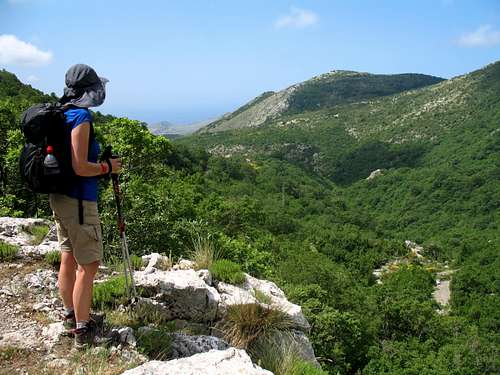
The ruined fortress was interesting to explore and from the battlements I could see a mountain that I thought was Rumija. The temperature was over 30 degrees and through the shimmering heat haze the mountain, looked a long way away.
We finished exploring the ruins and went into a bar for refreshments and discovered the local Niksicko beer – possibly the best lager outside of Belgium!After that we decided we would look for the start of the route at the north side of the old walled town, just around the corner from the bar. I didn’t hold out much hope of finding anything as we hadn’t seen any evidence of footpaths so far.
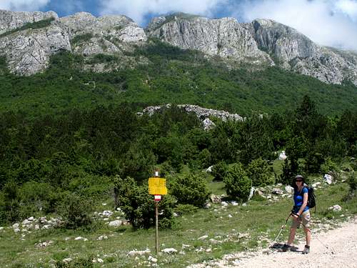
We walked around the corner of the wall and saw the minaret of a Mosque. Marie pointed, “There’s a signpost!”
Sure enough, a yellow footpath signpost showed the start of the route. We followed the red and white markers along the narrow roads, between the buildings to the edge of the town and out into the open countryside. A rough dirt track headed north eastwards beneath a cliff, full of nesting Crows and into the mountains. Easy!
The following day we awoke to grey cloud and a forecast of thunderstorms, so our attempt was postponed until the next day. That day started with blue skies and another promise of a hot day with temperatures over 30 degrees again.
We caught the earliest bus we could get (without skipping breakfast) got a taxi from the bus station and found ourselves back at the start of the route at 9.25 am – not as early as I would have liked but we were off.
Montenegro has a high level of rainfall near the coast from September to April and consequently, the landscape is covered with green and flowering vegetation and a profusion of insects. Lots of butterflies, ants, beetles and flying insects. Swallows wheel through the air, hunting for food for their babies.
I had the map and a route description from SP (Vvujisic’s Rumija page) which says the estimated time for the route was 4-5 hours – I hoped we would be nearer the 4 hours than the 5 but we decided to see where we were at 1.30 pm and plan what to do from there.
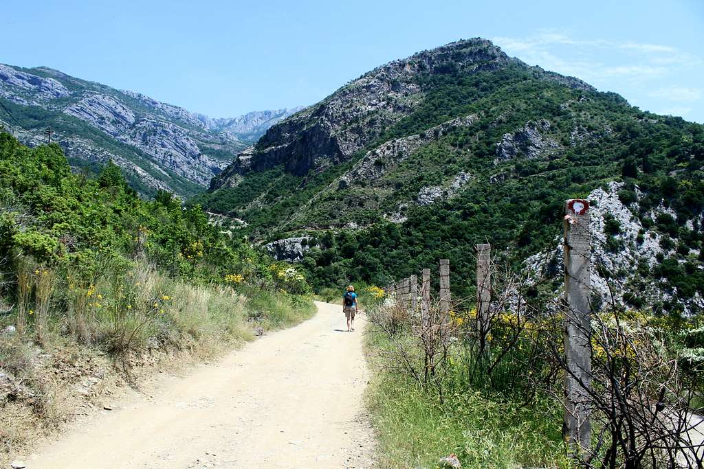
We followed the wide dirt track we had started along two days before which descended to a river then branched up leftwards.
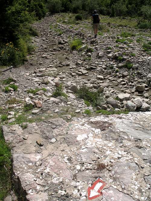
I didn’t expect the route to be marked but the red and white markers continued throughout the day and made navigation easy although I thought the accuracy of where we were on the map was not always reliable.
We made good time along the track in between the lush, tall vegetation. At a bend in the track, our signs told us to follow a vague path into the undergrowth, we followed but this was a mistake. The path was really overgrown, it slowed us down as I tried to push my way through, I got scratched by thorns and covered in spider’s webs. We emerged back on the same wide dirt track a little later, we had cut across a large bend but it had probably taken us longer than if we had stayed on the track.
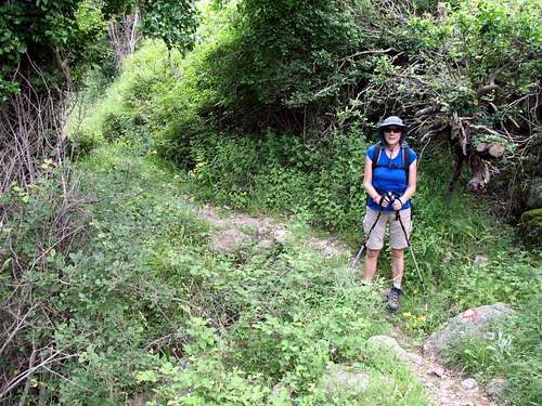
We passed some remote farm buildings, got chased up the track by three tiny dogs until the track ended and our way continued on a narrow, rocky path enclosed by thick vegetation. This was no shortcut, it was the main route and I wasn’t feeling too happy about it.
Firstly, the path was criss-crossed with spider’s webs… I hate spiders!
Secondly, I had read that Montenegro had a lot of snakes (this is an understatement!) and that one of them (the Horned Viper) is the most poisonous in Europe. Now we have snakes in the British Isles (Grass snake, Adder) but nothing like the sort of snakes in these hills. I don’t think I have seen more than a handful of snakes in Britain in the last 25 years. Here, they are all sizes and love to hide out amongst rocks covered with vegetation where they can ambush prey.
Thirdly, the path was full of rocks covered with vegetation, not only would this slow us down but it was just perfect for…I think you see where I’m going with this!
“What are you doing?” Marie questioned my actions.
I was walking with two walking poles. As I moved forward, I leant on one pole and swung the other skywards above my head (to break the spider’s webs!). Then, I bought it back down and struck the rocks ahead of me (somewhere I thought I remembered that snakes can “taste” vibrations in the air with their tongues. I hoped that by striking the rocks, they would realise I was coming and slink off before I got near – this didn’t really seem to work!). Then, I repeated the process with the other pole, I must have looked like a demented robot! I had to be careful not to stumble on the rocks and still got covered in webs!
“I can see spider’s webs, glinting in the sunlight like streamers off of your head”, Marie said.
|
|
Every now and then, the undergrowth to the side of the path would rustle as some creature ran through it, I convinced myself they were just lizards. Up ahead a few paces, I saw a bush move. I stopped and poked the bush with my pole. Suddenly, the whole thing shook and something crashed through the undergrowth away from me! I didn’t see what it was but saw a flash of something brown.
I gasped with surprise.
“What was it?” Marie asked.
“I didn’t see for sure. It was brown and large. Could be a Fox or a Rabbit. Maybe it was one of those snakes, they are supposed to be quite big?”
Marie thought for a second. “It was probably a Rabbit.” She said.
We continued along the enclosed path. I had just about convinced myself that all I had seen was a Rabbit when… up ahead a bush moved. I tapped the rock, just next to a tree root. The tree root squirmed under the rock!
“SNAKE!” I shouted jumping backwards, stopping right in front of Marie.
“What do you expect me to do?” Marie asked.
“Actually, it wasn’t that big but it’s under that rock in the middle of the path, so be careful.”
I hopped around the rock, Marie followed without incident and we continued as before. To be fair, none of the snakes were aggressive, it was just me that was freaked out!
It was a relief when the path opened out into a track again. No more spiders or hidden snakes. We moved quickly again until just after a lonely graveyard overlooking a valley, the path closed in again although, not as narrow as before.
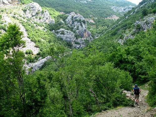
As we descended a short hill, I thought the main track was continuing around to our left but the red and white markers showed our route was heading up on a rocky path through a wide gorge. I consulted the map.
The route on the map seemed to show we should stick to the main track which took a long northwards loop before returning but there was a faint, grey dotted line to indicate a shortcut path heading up and eastwards. This seemed to be the path we were being told to follow.
“Do you think this is the right way?” Marie asked, looking over my shoulder.
“I’m not sure but the markers are pretty clear and all the time we have them, I think we should follow them.”
We agreed and I returned to my demented robot walk.
The path here was rockier but more open and a little steeper. We made progress to a viewpoint and our eyes were drawn back to our first view of the coast. Nearer to us, it was clear that someone had cleared some level ground to plant crops, a small golden patch in the greenery.
Now we were following a stream tumbling down the rocky landscape. Thank goodness for the red and white markers on the rocks as it was often difficult to discern a path without them.
It had been really hot so far but we had noticed that clouds were forming above us blocking any views of the mountains. It was cooler in their shade but I was worried about the possibility of thunderstorms.
A red rib of broken slate or shale appeared rising up from the predominantly white limestone rock and our route followed its crest with metal stakes and cables as a rather wobbly “bannister”.
To our left across the shallow valley, we could see a track cut into the hillside. It appeared to be converging with our path a bit higher up. The track had a distinctive zig zag in its otherwise straight design just above us. I consulted the map and looked at where the shortcut re-joined the main track. Sure enough, near the top of the shortcut path I had imagined we were on and just before it re-joined the main track, the main track had a distinctive zig zag.
“I think I know where we are” I said.
Five minutes later we re-joined the main track. I checked my watch, 11.30 am, just over 2 hours since leaving Starri Bar. I didn’t think that was too bad.
Up ahead I could see a signpost and stopped by it for a drink as Marie approached. It was really old and the writing was terribly faded by years in the hot sun.
I read it as “Rumija – 1:30min”. Excellent, we’ve been even quicker than I had hoped.
Marie arrived and looked at the sign. She sighed. “Not going to make it are we?”
“What do you mean?” I said.
“The top is still four and half hours away, we won’t make that.”
I jumped up and looked at the sign again…she was right.
I had thought it said 1:30 but actually, it said 4:30. I couldn’t believe it.
We sat and discussed what to do.
I was surprised we had been going so slowly – it certainly didn’t feel slow. We could keep going for a long time but we still had to re-trace our steps back to Starri Bar. Then, we had to get transport down to Bar. We had discovered there was a local bus despite the lady in the ticket office telling us we had to get a taxi but we had no idea what time the bus or taxis would finish. I couldn’t see the taxi drivers hanging around much after 6pm and didn’t know the local bus timetable. I didn’t fancy having to walk the extra 4km down and probably in the dark by then. Also, we were drinking our water much faster than anticipated and it was clear that we wouldn’t have enough for another 8-10 hours.
“Let’s keep going until 1.30 pm like we said and see where we are then.”
Marie nodded and we set off again just after 11.45 am.
There was another track descending northwards that wasn’t on my map which perplexed me – unless we were in a completely different place? The sign indicated to places on the map but seemingly in the wrong place? I haven’t been able to resolve that query.
Our track was wide with vegetation on both sides, its surface is a mixture of dirt, tarmac or concrete and not as steep as the rocky path had been. It is part of the “Coastal Transversal long-distance footpath” (PPT) that stretches down the Adriatic coast.
I noticed a mixture of Pines, Oaks and flowering bushes in the undergrowth and as usual, Butterflies and other insects were everywhere.
“This is not at all how I had imagined it” I said as we walked along.
The pictures I had seen on Google Earth had appeared to show a dry, barren landscape instead of the jungle around us. It was hot but the clouds were low and blowing through the trees. Every now and then we got a waft of cool, damp air to refresh us.
We passed another signpost, “Rumija – 3:30 min”. I checked my watch, we had knocked an hour off the time in 30 mins.
We had to stand aside as two cars passed us. One was an ordinary 2wd Peugeot carrying a young girl and (presumably) her father. The other was a man in a people carrier.
We continued, I was surprised we had no views but the low cloud seemed to be blocking the views towards the coast. Occasionally, we saw the craggy ramparts of Rumija above us but still a way off.
We reached the top of a rise and saw a signpost, this was marked as “Dobri Do” on the map but not on the signpost. ”Rumija - 2:30 min”, the sign said, it was just before 1.00 pm, we had knocked another hour off in 30 mins.
Further down the track, we could see a white building with metallic, gold topped turrets reflecting brilliant yellow light when the sun caught them. To us, it seemed completely out of place in this landscape. I think this is a Russian Orthodox Christian church and behind it was a big house. Neither of these were marked on my map!
“I need to have some food” Marie said.
“Yes, let’s sit and decide what to do.” I replied.
We ate and drank, we checked the map and the route descriptions I had with me. This was the situation.
The signpost said it was 2:30 min to the summit.
All the route descriptions said it was 1:30 min to the summit.
It had taken us 3:30 min to get to this point, exactly what the route descriptions had said.
“Best case scenario, if we make it in 1:30 mins,” Marie said “we will be there around 3.00 pm. Even it we only stay for a short time it must be at least 4 hours all the way back down to Starri Bar. That will make it after 7.00 pm and later if we are slower.”
I continued, “we don’t know if we can get a taxi or bus at that time down to Bar and we have to get a bus after that from Bar back up the coast. On top of all that, we’re getting low on water. I don’t know if I want to risk drinking water from the streams and these clouds could get worse, do we want to risk being struck by lightning?”
At some point we decided we ought to turn around while we had plenty of time, by the time we left it was 1:45 pm. The clouds started to clear, it still looked a long way to the summit. I am always reluctant to turn back before reaching the summit but as the sun came out it got even hotter and with a limited amount of water left, I couldn’t make a good argument to carry on upwards.
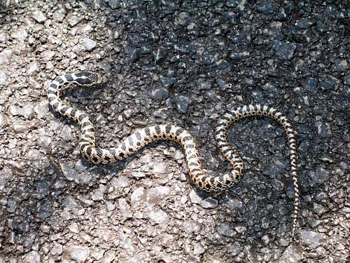
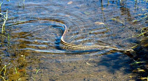
We re-traced our steps. Ahead of me on the tarmac, I noticed a “squiggle” on the road, a snake!
We crept up to it, it was only small but didn’t move.
“Do you think it’s sunning itself?” Marie asked.
“Either that or it was run over by one of those cars!” I replied.
I gently poked it with my walking pole. The creature was stiff and its whole body moved across the tarmac about an inch.
“I think it’s dead.” I said
I bent over to take a photo of it. I took one and leant in to get another.
“Err…Mike!” Marie said, alarm in her voice.
I had seen it… the dead snake had moved!
I jumped up as it turned its head, it didn’t seem too concerned with us so we wondered if it was injured. We left it and continued on.
We left the track and descended the footpath, it seemed to be getting hotter all the time as the cloud had completely gone. We now had views towards the coast and the hills to the north west which we reckoned formed part of the long-distance footpath route. Down the rocky path, down the broken shale rib following the red and white markers back into the narrow vegetation enclosed path.
The spiders had re-built their webs and there was constant rustling in the undergrowth either side of the path. Sometimes I thought I could discern tiny footfalls (lizards) whilst other times sounded more like a slither!
Suddenly, the grass in front of me exploded as a meter-long brown snake shot from the grass into a bush, it happened so quickly it was over before I realised it. After that, I just wanted to get down.
We saw a large brown lizard and what I thought was a small snake. Then a bit lower a large Balkan Green lizard ran across the path.
Something in the grass was moving. I parted it with my pole and saw a mottled green and brown shape moving.
“I think it’s a huge snake” I whispered as I tried to get a better look.
I pushed the grass further back.
“It’s a Tortoise!”
The Tortoise was going somewhere, he was determined to continue and wasn’t worried by us.
“It must be someone’s pet that escaped, he isn’t scared of us.” I continued.
“Where do Tortoises originate from?” Marie asked.
Apart from the Galapogos Islands, I had no idea. Next day, Marie pointed out something from the back of the map. Hermann’s Tortoise – native of Montenegro!
We reached Starri Bar at about 5.00 pm, 3 :15 min since leaving Dobri Do and found a stall selling juice at 1e a cup as our water had all but gone.
We had enjoyed a day in the mountains and seeing (most of) the wildlife. I was frustrated to have had to turn back but I could see we may have been descending the snake filled narrow paths in the dark and then struggling to get back to our hotel and probably spending a fortune on a taxi!
We needed an earlier start for a longer time on the mountain, more water or maybe a lift in a car up that road from Tudemili on the southern flank of Rumija. Having said that, I have always tried to observe the old adage “in mountaineering, you should always give the mountain a sporting chance!”
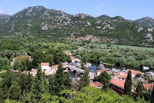
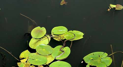
Later in the week we visited Lake Skadar with a view to exploring its shores. We used a bus and train to get there. Despite claims that there are a lot of walking routes, we found a lot more snakes and birds but few footpaths. Most of the (very hot) day was spent walking along the lake side road. The lake is huge and lies on the border with Albania. We only saw the area around Virpazar (again, no local maps) but at the moment it seems the best way to get around here is by boat.
We abandoned any plans to hike in Lovcen national park and settled for the (25e) taxi ride from Cetinje to visit the mausoleum of Petar II.
Map
Skutari-See (Lake Skadar) 1:55 000 – Kartographie Huber Gmbh
Guide
The Mountains of Montenegro – Cicerone
https://www.hylawerkgroep.be/jeroen/index.php?id=45
Really good site showing reptiles of Montenegro
|
|