|
|
Mountain/Rock |
|---|---|
|
|
56.85751°N / 4.29003°W |
|
|
Hiking, Mountaineering |
|
|
Spring, Summer, Fall |
|
|
3199 ft / 975 m |
|
|
Pronounced – a-var-conik
Scottish Gaelic - A' Mharcanaich
Summit height - 975 m (3,199 ft)
Meaning – The Horse place
Drumochter pass
(Scottish Gaelic: Druim Uachdair = High ridge.
The Drumochter pass is a pass between the mountains of the northern and southern central Scottish Highlands. The A9 road is routed through here, as is the Highland Main Line, the railway link between Inverness and the south of Scotland.
The pass is the only gap in the main Grampian mountains suitable for road traffic routes for almost 100 km, between the pass of Glen Coe in the west and the Cairnwell further east. The West Highland Railway has only one other crossing of these mountains, at Corrour.
The gap has been shaped into a U-shaped valley by glacial action over successive ice ages. From the top of the pass, we have the River Garry flowing south, and the River Truim flowing north.
A track through the pass has been used since prehistoric times and was the main route for drovers moving their flocks north to south.
A network of military roads, commonly referred to as General Wade’s Military Roads, were constructed in the Scottish Highlands during the middle part of the 18th century by the British Government after the Jacobite rebellion of 1715.
Under General Wade, a road through the pass was constructed to help with troop movements between the fortified barracks already in existence in the highlands. Although the road itself was upgraded over the years, the route remained largely the same until the 1970s when the whole road was modernized.
It is the high point on the A9, at 460 m (1508 ft) making it a good starting point to climb the mountains. The summit of the railway line is 452 m (1480 ft), making it the highest railway in the UK. As this is a high pass, it often attracts poor weather and this should be borne in mind when planning any undertaking.
|
Overview
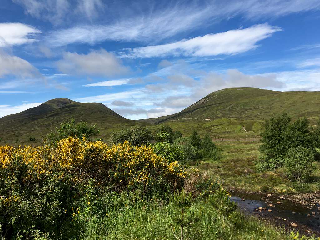
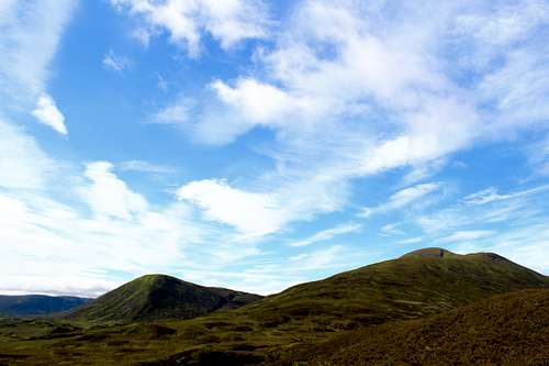
One of the West Drumochter pass Munros, along with its neighbours, Geal-charn, Sgairneach Mhor and Beinn Udlamain. Although A’ Mharconaich can be climbed on its own, it is more often climbed in combination with one or more of the other three, weather permitting. There are great views north across the pass towards the main Cairngorm range.
These mountains are on the southwestern edge of the Cairngorms National Park. However, they are not usually considered to be part of the Cairngorms mountain range.
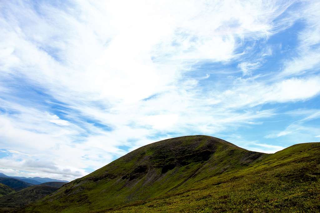
Unlike its neighbours, from the road A’ Mharconaich appears as a mountain with quite a dramatic proposition. It has a steep, craggy east face set in a high corrie and an attractively curved northeast ridge. However, like its neighbours, it too is mostly covered in grass, moss and heather. It has an almost flat, plateau like summit ridge with a covering of scattered rocks along its crest. The summit cairn is set at its northeasterly end, above the northeast face.
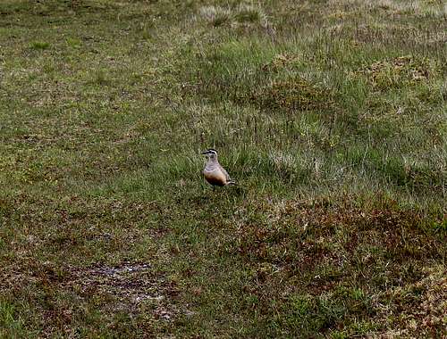
This high mountain tundra is a good place to see Dotterel from May to October. This ground nesting bird is relatively rare in the UK and has been described as “trusting” which means it will happily walk around in front of you.
Other, more common, ground nesting residents are the Golden Plover and ringed Plover. Please keep dogs on a lead!
In the winter, snow is a regular feature of the landscape and the A9 is sometimes closed to traffic if it is particularly bad. For the walker, the presence of the A9 is both a blessing and a curse offering ease of access to the mountain but also, its existence being something of a “blot” on the landscape. The high starting point within the pass is another positive for anyone wanting to climb this peak.
Getting There
By road:
From either the south or north, the main A9 road links Glasgow with Inverness and runs via the Drumochter pass and past the foot of the mountain.
From Glasgow, head north on the M80, then M9 to Stirling and on to Dunblane where this becomes the A9
From Edinburgh, head west on the M8, join the M9 and head northwest to Stirling and onwards to the A9.
From Inverness, head south on the A9.
It’s possible to start the route from a free car park at the Balsporran cottages on the west side of the A9. Otherwise, there are numbered laybys on the A9 where parking is allowed.
By rail:
There is a railway station in the small town of Dalwhinnie, just to the north of the Drumochter pass. Most trains will either start or pass through Edinburgh and Glasgow from the south and Inverness from the north. These are relatively infrequent and the local timetable should be referred to.
Route
For any ascent of A’Mharconaich, it is a good idea to start from the car park at the Balsporran cottages on the west side of the A9.
It is possible to start by ascending Geal-charn and carry on to climb A’Mharconaich, see West Drumochter pass Munros route (below) for this description.
Starting points:
Balsporran cottages car park (free). – Map reference 627792
Blue route for the ascent of Coire Fhar
Leave the car park and cross the bridge over the River Truim heading towards the cottages. Pass in front of them and cross the railway line on the level crossing.
Continue ahead on the track running parallel to the Allt Coire Fhar and cross a tributary. Ignore a track to the right and continue to cross a small bridge.
After this, continue following the main track up into the Coire Fhar until the track reaches the bealach at 793m.
Red Route for the ascent of A’Mharconaich
From the bealach at 739m, follow the track for a short distance then head east up the steep grassy slope of A’Mharconaich.
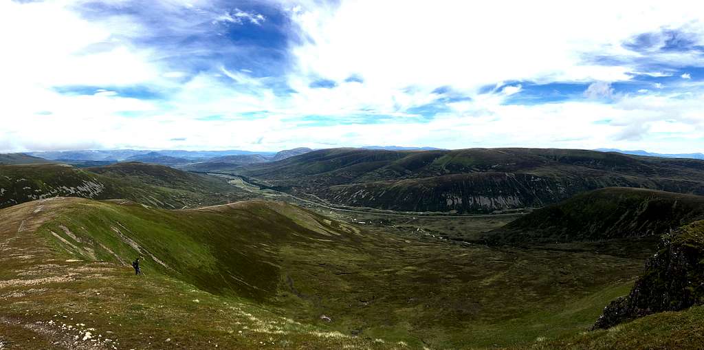
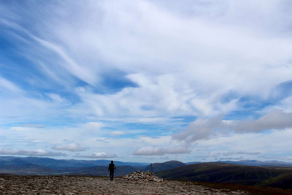
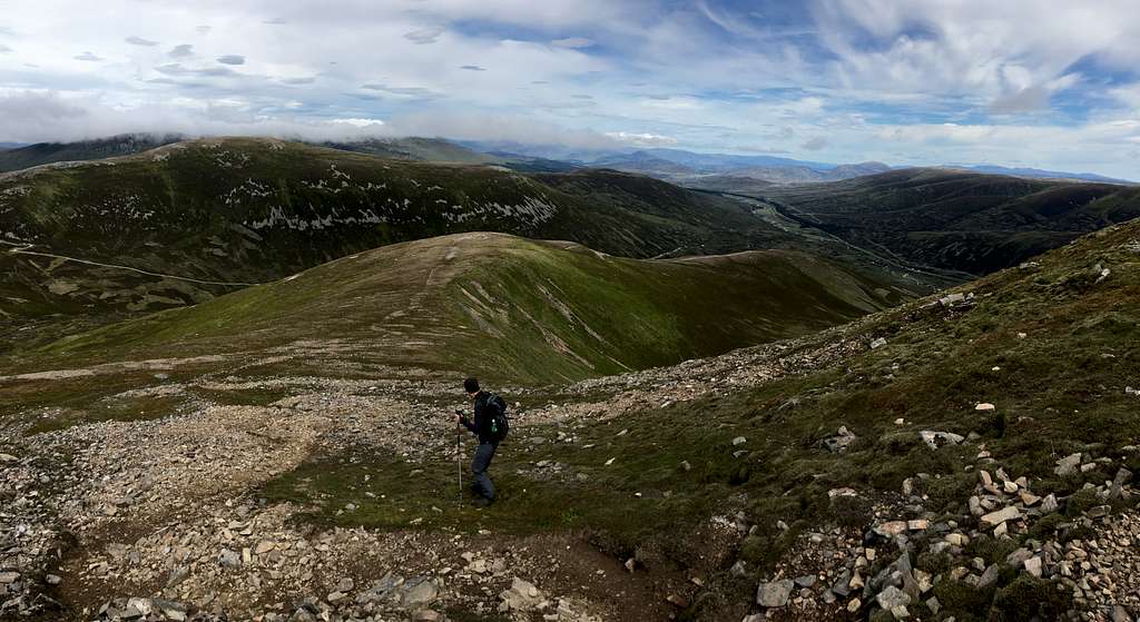
When the broad summit ridge is reached, turn left to the northeast. The ridge appears to be quite flat but rises to a cairn at the northeast end. This is the summit of A’Mharconaich (975m).
Beyond this, the ridge ends where it drops into a high coire with views to the north.
Purple route for the descent of the northeast ridge.
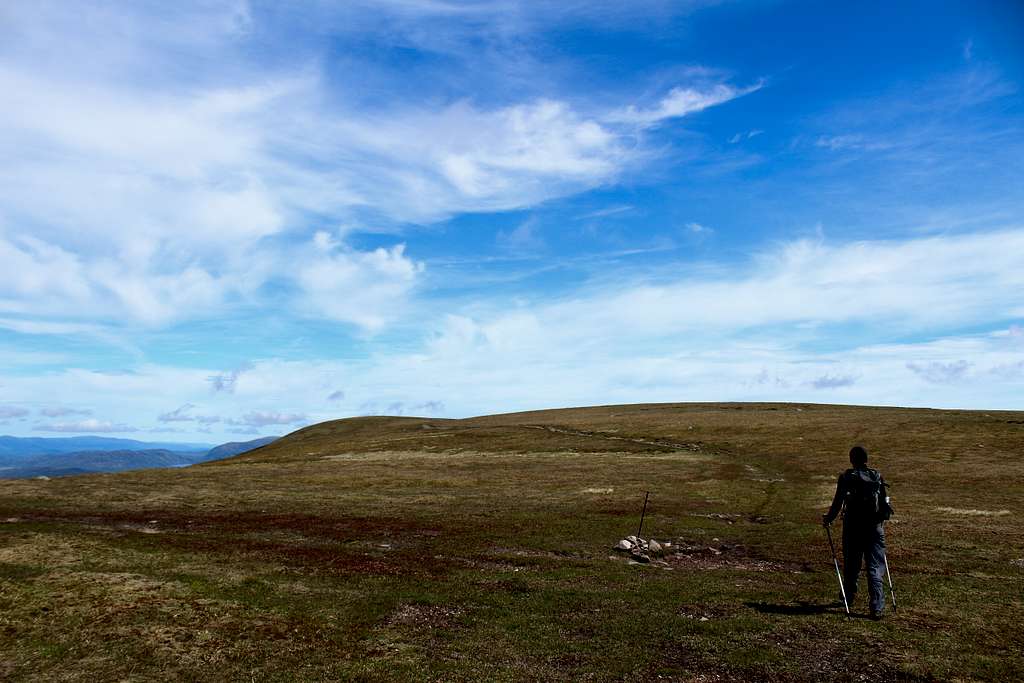
Head north then northeast around the rim of the coire. This is steep at first and quite rocky but it soon becomes a feint path through the grass.
As the angle lessens, it becomes easier to descend and the ground can be covered quickly (this is a good descent route if the weather turns bad).
As the ridge runs out, it may be that the route becomes boggy. It is possible to head towards the Allt Coire Fhar and cross it to the ascent track on the far side. Otherwise, descend until the river is reached not far from the level crossing.
Cross the river where possible on stones and return to the Balsporran cottages and the car park.
It is possible to traverse the four Munros in the area in one go although, this is obviously a much longer undertaking.
For the description of the traverse of all four Munros see the West Drumochter pass Munros route page.
Red Tape
Scotland has an Outdoor Access code, see link:
https://www.outdooraccess-scotland.scot/practical-guide-all
The area is popular for Deer stalking and Grouse shooting. These activities may impact on any plans for hiking. However, it is still possible to hike during these events with a little extra effort at the planning stage.
This is a useful page on the Outdoor access – Scotland website
https://www.outdooraccess-scotland.scot/practical-guide-all/heading-scottish-hills
When to Climb
Spring, Summer or Autumn (Fall) depending on conditions.
Warning: The above descriptions are for use in reasonable summer conditions. Winter conditions can occur at almost any time of the year. In winter condition, these mountains are a much more serious proposition. Any paths may be covered by snow and ice and gale force winds are common. Ice axe, Crampons, the knowledge of how to use them allied with excellent map reading and compass skills are essential.
Accomodation
A limited number of Hotels and self-catering accommodation around Dalwhinnie and Newtonmore are the closest, followed by Blair Atholl and Pitllochry. Aviemore is approximately one hour’s drive away.
There are some campsites or caravan parks in Dalwhinnie and Kingussie.
It is possible to wild camp in Scotland. See the Outdoor access code for more details.
External Links
Walk highlands - https://www.walkhighlands.co.uk/
SMC - https://www.smc.org.uk/
Cairngorms National Park - https://cairngorms.co.uk/
The Central Highlands – Peter Hodgkiss (SMC District guide)
The Munros – (SMC Hillwalkers guidebook)
The High Mountains of Britain and Ireland – I. Butterfield
Birds of Britain and Europe – Nicolai/Singer/Wothe
Ordnance survey map OL50 – Ben Alder, Loch Ericht and Loch Laggan