Whitney - the Long Way
For my summer adventure in the High Sierra, I decided to do something not so original – a hike to the top of Mount Whitney. To do that, one needs to pick a route to the top. I decided to go the long way starting in the Yosemite Valley.
Almost anyone who has spent a meaningful amount of time in the High Sierra is familiar with the John Muir Trail. I would venture to guess that most long-time Sierra lovers have considered making the trip at one time or another. For me, the JMT was always a project in the back of my mind, but I always dismissed the notion under the working theory (excuse) that I did not have time. The recommended three-week time frame was simply not a reality given professional and family responsibilities.
Nevertheless, last winter the thoughts of the JMT became impossible to cast aside. With my mountain climbing ambition waning for the time being, the thought of a long distance backpack represented a new challenge. I had climbed a number of peaks that required a somewhat lengthy hiking approach before, but hundreds of miles on the trail was a completely new prospect.
A personal appeal of the JMT was the amount of terrain in the Range of Light that I had not previously encountered. Although my journeys in the High Sierra have been many, most of them were confined to Yosemite National Park and the peaks in the vicinity of the magnificent Sierra Crest.
Starting in Style
A pre-trip romantic dinner with Trina at the Ahwahnee dining room was a good kickoff. As a bonus, it was a refuge from the acrid smoke plaguing the entire state of California during this lost summer in the Golden State. I almost abandoned the trip for want of healthy, pollutant free skies but encouragement from heads cooler than mine placed me back on track.
Not content with fine dining on the west side of the Sierra, my first day of hiking (Happly Isles to Tuolumne Meadows) ended with Trina picking me up on the Tioga Road for a final fueling before my long trudge across the high country. Off to Whoa Nellie, this time for lobster taquitos, which narrowly beat out my usual favorite of Kansas City Steak Caesar salad. Between WND and the Ahwahnee I was well fueled with haute cuisine. Advice #2 – Eat up in style before stuffing that bear can full of dehydrated goodness.
Trippin' Through the Range of Light
A long trip like the 220 mile JMT does require a fair degree of logistical planning. Many an hour on rainy weather evenings was spent reading poring over the maps and guidebooks to plan a rough itinerary. Eventually, after a thorough review of the mileage charts and potential camping sites, I decided on a 10-day trip on the JMT with a re-supply at Edison Lake. Nothing close to record breaking territory, but not so leisurely either. Hard work lay ahead.
Advice #1. Plan an itinerary for camping sites, but be flexible too. However - make sure not to miss camping at Thousand Island Lake (or Garnet Lake)!
Hike On
Most trip reports tend to take the format of an intensive chronology. For me, memories of a wonderful trip in the mountains tend to take the form of random recollections of sights, sounds, conversations, emotions, triumphs, defeats, and other such things. So this report will be a collection of memories and ruminations of my 200+ mile battle with mosquitoes, mud, snow, river crossings, endless climbs over pass after pass, blisters, and other inconveniences.
First and foremost were the bugs. Long Meadow, located in the sublime Cathedral Range, was my introdcution to those bastard blood sucking mosquitoes – all bad. Four coats of DEET only served to encourage them. I discarded the idea of the fifth coat as it wasn’t worth the hundreds of bites I would get during a two-minute stop. Anopheles would plague me for more than 200 miles throughout the High Sierra, but no place worse than Long Meadow.
JMT Advice #3 – Spring Flowers and Green Meadows bring on the bugs – don’t forget that bucket of repellent.
There was also water, water everywhere. The big flows in Vernal and Nevada Falls should have clued me in that rumors of a drought year in the High Sierra were greatly exaggerated. No doubt was left after Donohue Pass, with the soft afternoon snow covering extensive sections of trail. Plunge step in – get feet soaking wet – lose trail – find trail - repeat. Of course truckloads of mud were easy to find too.
This theme would emerge frequently at the high passes. The worst of the snow struggles had to be the drainage on the south side of Muir Pass. Honestly, it felt like the entire mountain range to the south of the Muir Hut was being carried out to the Pacific in a giant watery slush ball, with me along for the ride. Taking 3 hours to hike a mile or so is an unkind cut when 20 miles a day is called for.
Advice #4: To pick your level of challenge on the JMT, basing your journey on the time of year will help. An August trip will largely minimize the hazards/annoyances of postholing through snow and losing the trail, wallowing through mud, being devoured by mosquitoes, and river crossings.
On the other hand, the grasses turn burnt yellow, the wildflowers disappear, there are fewer places to fill your Nalgene, and little of the appreciation for the hazards of nature may disappear.
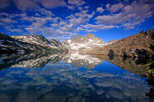
Once far removed from the Yosemite Valley masses - even though I started hiking at 5:00 a.m. on a Thursday from Happy Isles I must have passed 50 people heading to Half Dome - I enjoyed my many conversations with my fellow backcountry travelers. One may solo the JMT, but rarely does it feel lonely. The positive spirit of the parties coming back from a successful summit of Mount Lyell, for example, would constantly raise my spirits.
I also particularly enjoyed my conversations with the PCT through hikers – they were all heading north while I headed south, having battled fierce desert and big snows already. Surprisingly, I think I met more PCTers than JMTers in 10 days of trail hiking. When apprised of my planned itinerary in conversations regarding our respective itineraries, only the PCTers didn’t think I was a lunatic.
My admiration for PCT through hikers, or any long distance hikers for that matter, increased greatly as a result of my own modest journey. More than anything, I am impressed at the toughness of their feet. And, damn, that is one long trail.
Far, far worse than the mosquitoes and the exhaustion of hiking 20+ miles a day with a full pack were the blisters and the associated 4:45 wake up alarm for another morning of blister care. Like gangrene, they started at the tips of my toes and worked their way up in both intensity and frequency.
By day 8, they were spontaneously erupting inside my socks just about everywhere along my feet. Advice #5 – bring lots of moleskin, duct tape, a little pair of scissors and whatever works for you. It took about a month or so for the remnants of a once great blister civilization to finally disappear.
Thus ends the complaining. The minor drawbacks are far outweighed by the magnificent scenery and of the Range of Light and the joy of leaving the many worries of the crowded, demanding lowlands behind, at least for a while. My guess is that even the great John Muir from time to time lamented having only tea to drink and hard biscuits to eat day after day in the wilderness although he obviously thought it worth the trouble.
A Mountaineer's Delight
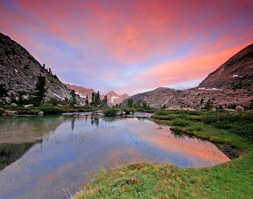
I was even more surprised by the beauty not so famous from the Sierra mountaineer’s perspective, such as the expansive views from Silver Pass and Marie Lake from Selden Pass. Around every corner is a splendid sight.
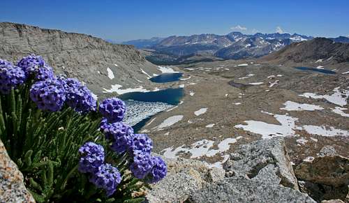
Other sights also capture the eye. The explosive blooms of wildflowers in LeConte Canyon and Palisade Creek. The hundreds of runoff fueled seasonal small streams. Dozens of green meadows. Fragrant fields of sky pilot in the highest, best alpine country in the Range of Light.
Surprisingly, the hours melted away so quickly each day. I would be hiking by 6:00 a.m. and before I knew it late afternoon would arrive, with memories of the expansive views from the high country, complemented nicely by the pleasant walks through the forested river valleys as a souvenir of my travels for the day.
One resupply is recommended – 10 days of food is a lot to carry and besides a little break from the trail doesn’t hurt. Mine was at Edison Lake. Like clockwork, the ferry boat arrives at the far end of the lake at 9:45 and 4:45– only about a mile and a half from the JMT. I made the boat launch at 3:30 on Day 4, about an hour to spare. My dad was kind enough to drive to Edison Lake provide my resupply, so I got the added benefit of heading down to the lovely Mono Hot Springs campground for a nice dinner and luxury of car camping. Advice #6: If you have the time, make it down to Mono Hot Springs for an awesome soak. My recommendation is to partake of the “Old Pedro” hot pool across the creek from the campground.
The northern section of the JMT is full of easy resupply stations. The southern portion, not so much. From Muir Trail Ranch to Whitney Portal wildness reigns on the JMT for more than 100 miles, each day a series of high passes and low forested river valleys. It is a great place to escape civilization with the exception of ranger station here and there, although no ranger checked my permit my entire time on the JMT.
Big Country
I planned longer days at the end of my journey, as my acclimatization would be best and the pack lightest. This was not a bad strategy in the abstract, although being faced with back to back 26-mile days and climbs over two high passes each day at high altitude makes it seem not so smart. Advice #7: The southern half of the JMT has some big, steep, hot, long slogs up high passes where snow may linger long. Plan accordingly.
The topographic maps, when reviewed ahead of time, can give the JMT planner a pretty good idea of what he or she can see along the way. However, there are unexpected and incredible surprises near the end of the trail, such as the hike up onto the Kern Plateau above Tyndall Creek. Like nothing else I’ve seen in the Range of Light – alpine tundra, ancient trees, splendid views of the Whitney group, expansive views of the awesome Kern Canyon, the remote Kaweahs in the distance, the prominent peaks of the Great Western Divide and the Kings-Kern divide. Even a veteran traveler of the Range of Light will be stunned at the spectacle.
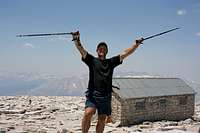
Of course, you eventually pass by the famous Guitar Lake, top out at Trail Crest and join the fun of the Whitney circus.
I must admit though, that the pack free slog from Trail Crest to Whitney’s summit was quite satisfying, like spiking a football after a touchdown.
Random Observations
Here is a summary of not so vital statistics and random observations:
Miles Hiked: 220 or so. On the plus side, it’s hard to get lost.
Packs of Moleskin: Around 2.
Rolls of Adhesive Tape: 1.
Acetiminophen Pills: Maybe 50 or so. Don’t leave home without the pain relief.
Total Rainfall: 0.00 inches. It’s not the Range of Light for nothing.
Bears observed: 0. A bit of a disappointment, but does reflect well on housekeeping practices.
Marmots Observed: Tons. Observing these year-round residents of the high country basking in the sun never gets old. Friendliest Marmot: A resident of the Silver Pass area.
Nastiest section of the JMT: The hike out of the Middle Fork of the San Joaquin just south of Devils Postpile- a hot, mostly treeless dry, endless death march. The hike from Little Yosemite Valley to Sunrise High Camp doesn't have much going for it either.
Best short deviation from the JMT: Go through Red’s Meadow and Devil’s Postpile. The current JMT route skirts the Postpile well to the west and is a hot, dusty, and largely pointless traverse that skips the good stuff. Better to join the tourists and check up close one of the geologic wonders of the Sierra. Wish I had.
Most Impressive Section of Trail Engineering: Hands down, the south side of Forester Pass.
Hardest Pass to Climb: Again, Forester Pass, especially with a healthy dose of soft afternoon snow. Descending the snow blanketed south side of Muir Pass was no picnic either.
An Unexpected Theme of the Trip: The heat. Even in the High Country, hiking up and down the trails involves much tolerance for the blazing hot sun. Drink often and keep eating salty foods to maintain equilibrium.
Coolest Man-Made Structure: The Hut at Muir Pass.
Scariest Man-Made Structure: The rickety footbridge over Woods Creek.
Best Soak: Mono Hot Springs!
Best River Crossing: North Fork of Mono Creek. It passes just below a lovely little waterfall tucked in a steep granite canyon. Advice No. 8,. Bring a pair of sturdy sandals for the many river and creek crossings.
Greatest Concentration of Those Suffering from Altitude Sickness: An easy one. Trail Crest to Whitney’s summit is THE place to observe voluntary human suffering.
Random Nice Event: A group of people, including a bunch of PCTers, giving me an unsolicited round of applause at the top of Whitney to celebrate my 10-day journey.
Pounds of Bacon: 1
Packets of Gatorade: 16. For a wonderful experience, throw in 3-4 packets of Gatorade into a water bottle filled with snow and water. Shake thoroughly and enjoy. Plus, it helps balance electrolytes.
Candy Bars: 10 or so.
Amount of dehydrated food: none, other than a few packs of dried apricots. My only requirement for bear can contents is that they be calorie intense and delicious.
Final Advice: If you are a lover of the High Sierra, take the time to go do this trek. While it does involve quite a bit of slogging an effort a mountaineer might consider tedious, the long journey connects to so many wonderful places in the High Sierra that otherwise might never be visited. Plus, if you have the time it’s not difficult to find peaks to climb along the way.


Comments
Post a Comment