Abdal Musa

Page Type Page Type: Mountain/Rock
Location Lat/Lon: 40.40850°N / 39.06674°E
Additional Information County: Torul
Activities Activities: Hiking, Mountaineering, Scrambling
Seasons Season: Spring, Summer, Fall, Winter
Additional Information Elevation: 10928 ft / 3331 m
Sign the Climber's Log

Overview

Abdal Musa (or Abdalmusa; also known as Karadag (“Black Mountain”) ) is the highest peak in the Gavur Mountains located within Gumushane province of Turkey. At 3331 m (10928 ft), Abdal Musa is also the highest peak of Gumushane province. The Gavur Mountains are a beautiful subrange of the Eastern Black Sea Range. They consist of a series of peaks, many of which exceed 3000 m (9800 ft) in elevation. Several glaciated valleys are present here, dotted with lakes. Wildflowers of all colors are found everywhere, sometimes covering entire meadows. The combination of snowy peaks, alpine lakes, abundant wildflowers, cascading creeks and waterfalls offers a wonderful experience in this lesser-known corner of Turkey. The area is protected as a national park under the official name of “Artabel Golleri Tabiat Parki” (Artabel Lakes Nature Preserve). The park’s protection status came in 1998 and covers an area of approximately 6000 hectares (23 square miles). Artabel is the old name of a village at the eastern side of the mountains. This village is now called Esentepe; it lent its former name to the newly-established park.
 Lake with an Island 
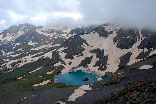
Adali Gol (Lake with an Island)


WaterfallWaterfall
Despite their magnificent scenery, the Gavur Mountains are virtually unknown outside of Gumushane, even in Turkey. This may be explained by the fact that the higher portions of the Eastern Black Sea Range further to the east (in Rize and Artvin provinces) get most of the attention. In particular, Kackar Peak, the highest peak of the range at 3932m (12900 ft, 4th highest peak in Turkey), is the main destination along the Black Sea Coast and overshadows most of the lower peaks, including Abdal Musa. Most mountaineers from the big cities such as Istanbul and Ankara prefer climbing Kackar or other high peaks of the range. The relatively remote location of Abdal Musa away from the Black Sea Coast and major tourist routes makes it less likely to have visitors. Although this lack of interest may sound bad, it is actually good news: the Gavur Mountains are clean, essentially unspoiled and offer solitude that may be harder to find in other, more popular climbing areas.

Geography

WildflowersWildflowers
The Gavur Mountains are the westernmost prominent peaks of the Eastern Black Sea Range. Further to the west, the mountain chain becomes substantially lower, eventually fading into the Western Black Sea Range in Samsun province. While the Eastern Black Sea Range runs generally in the east-west direction, the Gavur Mountains run predominantly in the north-south direction. Extensive glaciation took place in the Gavur Mountains during the Pleistocene period, as a result of which, today we see many glacier-scoured cirques and lake basins, sharp peaks and ridges, U-shaped valleys, polished rock surfaces, morain deposits, etc. There are no glaciers today, but remnants of glaciers (permanent snow fields and snow fields that don't melt until late summer) occupy north and east faces of some peaks and cirque walls.
Glacial LakeA glacial lake in the Gavur Mountains


Flying over GiresunView from the air
If you are flying into Trabzon, you may catch a glimpse of the Gavur Mountains as the plane is flying over Giresun or Trabzon. Look to the south for a snowy mountain range. The Gavur Mountains are easy to spot: they are the highest of the region. In fact, no other peak to the west along the Black Sea Coast rises higher. If you missed this view, don’t worry. You will get a better chance on your way from Trabzon to Gumushane. When you come out of the Zigana Tunnel, look towards the southwest. You won’t miss the impressive views of the snowy Gavur Mountains. As the road winds its way down to the Harsit River near the town of Torul, you will get to see these mountains from many different angles.

The Gavur Mountains are one of the main sources of water in Gumushane and feed several tributaries of the Harsit River. The Harsit River has the distinction of being the only river that cuts across the crest of the Eastern Black Sea Range. A deep valley has been carved by the Harsit River between the Gavur Mountains to the west and Zigana Mountain to the east. The Harsit River drains about half the province and empties into the Black Sea at Tirebolu/Giresun. The Harsit River Valley also serves as the most convenient transportation route between Gumushane and the Black Sea Coast. Other routes must cross high passes over the Eastern Black Sea Range. For instance, the route between Gumushane and Trabzon climbs Zigana Mountain, passing through the Zigana tunnel at an altitude of 1820m.
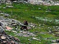
A local residentA local resident
The region around the Gavur Mountains is sparsely populated with villages or “yaylas” (summer camps for sheep/cattle herding). The nearest towns of reasonable size are Torul to the east (population 5000), Siran to the south (population 12000) and Alucra to the west (Giresun province, population 12000). All three towns are at least 30km away.

How To Get There

Bridge over Cit CreekBridge over Cit Creek
Two main tributaries of the Harsit River provide the most convenient access to the Gavur Mountains. These are Cit Creek and Gulacar Creek (aka Musalla or Nivene Creek). Both creeks flow east through two paralel valleys which are joined by a ridge of the Gavur Mountains. Downstream, Cit Creek joins the Harsit River near Torul. If you follow Cit Creek, the village of Gumustug (elevation 1800 m) will be the starting point of your hiking/climbing trip into the Gavur Mountains. Gulacar Creek joins the Harsit River in a place called Ikisu (“Two Waters”). If you follow Gulacar Creek, the village of Artabel (aka Esentepe, elevation 1900 m) will be the starting point of your trip. Depending on your time available and your objective, you can pick whichever suits your goal best.

Wildflowers by a streamMountain daisies by a stream
The Cit Creek/Gumustug approach requires a shorter drive and will get you closer to Abdal Musa. If you have limited time or your objective is only to climb Abdal Musa, which can be done easily in a day, this route is recommended. However, the headwaters of Gulacar Creek and its lake basin are more scenic. The Gulacar Creek/Artabel approach is highly recommended if you have more time.

The Gavur Mountains can also be approached from the north, south and west. However, all these approaches require much more driving than the two described above. For local people, the closest approach is fine, but for most outside visitors, these two are the most convenient.

Camping

BearsTwo bears
Camping can be done in any of the lake basins. Note that timberline in the Gavur Mountains runs a little above 2000 m (6600 ft), which is well below the areas you are likely to camp. So there is no tree or wood available for campfire. You must bring your camp stove and fuel. Also note that bears live in the Gavur Mountains. Take precautions so as not to attract bears, for example by keeping your food items closed.

A Bit Of History

The Gavur Mountains were once the scene of a fierce battle between the Ottoman Empire and Russia during World War I. The Russians have advanced well into Gumushane, while the weakening Ottoman forces were withdrawing. The Ottoman soldiers took refuge in the Gavur Mountains, trying to establish their defences. However, an intense artillery campaign by the Russians caused huge losses on the Ottomans. It’s said that an entire battalion was lost, much of it by drowning in a lake. After a year of occupation, the Russians withdrew when the Bolshevhik Revolution took place. There are some trenches and grave sites in the mountains from the wartime. Please be respectful of these sites.

Red Tape

The author is not aware of any permit requirement from the National Park Service of Turkey for either dayhikes or multi-day trips. However, the local gendarme (in Torul district) would like you to inform them of your plans for the purpose of security (of your own) and in case a rescue is necessary. The Gavur Mountains are generally safe. However, you are strongly recommended to check with the gendarme before your trip. You could visit their Torul station on your way. Perhaps you might be able to do this, or at least get some information, by contacting a Turkish consulate near you (preferably in your own country). Ask them to contact the gendarme of Torul district/Gumushane province, and find out if there are any restrictions at the time of your trip, which is not likely.

External Links

Wikipedia entry for Gumushane

Wikipedia entry for Kackar Mountains

National Park Service of Turkey (in Turkish) - Doga Koruma ve Milli Parklar Genel Mudurlugu

Office of the Governor of Gumushane (in Turkish) - Gumushane Valiligi

Etymology

The name Abdal Musa refers to “Abdal Musa Sultan,” a philopsopher, poet and an important religious figure who lived in the 14th century. Abdal Musa Sultan was born in Khorasan, Iran. He lived in Turkey (then Ottoman Empire) for much of his life. The history books credit him for helping the Ottoman Sultan Orhan Gazi to capture the city of Bursa from the Byzantines. His “turbe” (shrine) is in Elmali, Antalya. Abdal Musa Sultan is a relative of Haci Bektas Veli, one of the principal teachers of Bektashism and Sufism (equivalent to a saint). It is believed that the name Abdal Musa was given by the villages of the Alevi sect living south of the Gavur Mountains in Siran district.


Children

Children

Children refers to the set of objects that logically fall under a given object. For example, the Aconcagua mountain page is a child of the 'Aconcagua Group' and the 'Seven Summits.' The Aconcagua mountain itself has many routes, photos, and trip reports as children.

Parents 

Parents

Parents refers to a larger category under which an object falls. For example, theAconcagua mountain page has the 'Aconcagua Group' and the 'Seven Summits' asparents and is a parent itself to many routes, photos, and Trip Reports.

Eastern Black Sea RangeMountains & Rocks