
-
 14012 Hits
-
 72.08% Score
-
 2 Votes
|
|
Route |
|---|---|
|
|
32.77000°N / 16.93°W |
|
|
Hike |
|
|
Less than two hours |
|
|
Walk-Up |
|
|
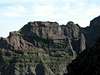
Approach
Follow the freeway R101 towards it end at Machico and head northwest on the coastal highway R 101 towards Santana. In Santana turn left (filling station, sign: Pico Ruivo) onto a side street that after 14km leads you to Achada do Teixeira.
Route Description
Altitude Gain: 270m
Duration: 1h
Trailhead: Achada do Teixeira (1592m)
This is the easiest of the routes described here. Just follow the almost level trail that leads by three refuges (!!) and finally gets steeper for the ascent of Pico Ruivo's summit. Enjoy the view of virtually all the island of Madeira at your feet.
 |  |  |  |
Essential Gear
Hiking gear is advisable, sneekers will do.