Day 1: A Grand Trip Spoiled and a Change of Plans

The climb of the Grand Teton was supposed to be the crowning trip of my 2009 summer; my coworker Jan and I had been planning the trip since March, and we had set aside August 9-12 as dates for the trip. We both teach at a college, and this was the last free week before we had to get back into the swing of things and a new semester. Jan had climbed the Grand twice before, and this was going to be my first technical climb. The day before my first
outing with Bob Sihler in June, I drove over to Jackson and saw the Tetons up close for the first time since my family drove through the area in 1988; I was six at the time and didn't really care about mountains yet!. As with countless others who have gazed up at what is arguably one of the world's most spectacular ranges, I was filled with wonder and amazement, and these feelings were soon joined with thoughts like "What am I thinking?" and "I must be crazy!" However, after some more practice climbing and reading up on the Owen-Spaulding route, I felt as prepared as I could be when early August finally rolled around.
![The Tetons]() The Tetons in late June, 2009
The Tetons in late June, 2009
On August 9, I drove from Cody, Wyoming to Jenny Lake through Yellowstone Park in the late afternoon after giving a small piano recital at the beautiful home of a friend who lives near
Heart Mountain. Jan was to meet me early the next morning, as he was driving back from Portland with his new truck. I got down there that evening just in time to catch the sun set behind Mountain Moran:
![Mount Moran sunset]() Mount Moran sunset
Mount Moran sunset
After a night sleeping in the back of my XTerra, I was first in line the next morning at the Jenny Lake Ranger Station to obtain our backcountry permits. I was soon joined by a number of climbers who were looking to
give back their permits for that night, pushing back their climbs by a day to let the ice melt off of the top. In the hurry to leave, I had forgotten to check the latest Teton conditions online, which were not good due to hail and a snowstorm several days earlier, meaning that I was unaware of the fact that there was thick ice coating the chimneys and the upper portion of the mountain. I went ahead and got permits (and the mandatory poop bags) anyway in spite of the fact that the climbing guides were recommending front points for some sections, figuring that Jan and I could figure out what to do when we met for breakfast at the Bunnery in Jackson. Given the fact that neither of us had brought crampons and that I had no experience on ice of any kind, we decided to return the permits (and poop bags) and save the Grand for another day.
So, here we were on Monday morning with no reason to be home until Wednesday night, and so we threw around a couple of ideas. We both wanted to do Cloud Peak someday (I ended up doing it a
month later), but rejected it in favor of a plan which Jan had been wanting to do for years. In 2008, I mentioned to him that climbing Trout Peak had been a dream of mine since I was a teenager growing in Cody; the lofty summit of the highest peak in the
Northern Absaroka Range had always drawn my gaze from my family's living room picture window, as it was just visible above the long ridge of Rattlesnake Mountain. Even the street we lived on was called Trout Peak Drive! Jan said that Trout was on his list of things to do as well, but after looking over maps of the area, he had come up with a plan to traverse the peak, going from the Jim Creek trail head near the Shoshone North Fork to the Northwest College Field Station near the top of Dead Indian Pass on the Chief Joseph Highway. We had agreed that we would do it someday, and this now seemed like the perfect opportunity. However, based on information from Turiano's
Select Peaks of Greater Yellowstone, we decided to do the traverse the other way, but instead of starting at the Field Station, we would start from Spout Springs near Pat O'Hara Mountain and end at Jim Creek. The primary reason for the switch was that the elevation gain going this way was roughly 4,000 feet up and 6,000 feet down instead of the other way around.
![Trout Peak]() Trout Peak (left) and Robbers Roost (right)
Trout Peak (left) and Robbers Roost (right)
As we were already packed for a couple of nights out, the only thing we really needed was some bear spray, which Jan purchased in Jackson. Anyone who ventures into the remote reaches of the Absaroka Range without this item is a much braver man than I; the only people I know personally who climbed Trout Peak encountered six grizzlies during their trip in the mid 1990's! After braving the mess of road construction on the Rockefeller Highway, we made our way through Yellowstone and arrived at the Jim Creek trail head just outside of Wapiti around 2:30 in the afternoon. After parking and leaving Jan's truck, we drove my car to Cody and bought a few odds and ends at Wal-Mart before stopping at the library to print off a few topo maps for the trip. We grabbed some sandwiches at Subway, and then proceeded north to find our way to the mountain. Our plan was to drive up to Spout Springs and get in a few miles before setting up camp, which would make for a shorter ascent on the second day in case there were some early-developing thunderstorms. However, eleven miles up the road, we encountered a confusing mess of signs that left us very unsure of the legality of driving any further on the road, including one that clearly stated that there was no travel beyond this point without a wood cutting permit. This area has been the subject of many legal battles over the years, stemming from issues regarding people passing through private land to access the BLM land on top of Rattlesnake Mountain, a problem which has been exacerbated by people who have mistreated the land with heavy off-road vehicle usage.
![Confusing signs]() Signs on Monument Hill Road
Signs on Monument Hill Road
This, combined with past knowledge of legendary stories about the landowner up there who chases people down in his Hummer and interrogates them with a gun while checking for a wood cutting permit, led to our decision to retreat back home to Powell for the night to make some phone calls and figure out what was really going on regarding access to the Shoshone National Forest at that point.
Luckily, Jan knows someone who works at the SNF office, and after several phone calls we were able to determine that the poorly-placed sign only applies to one of the forks at the intersection. Armed with this knowledge, we agreed to leave at 4:45 the next morning.
Day 2: Solitude and a Perfect Day
Part 1: Robbers Roost

After retracing the road to the previous evening's highpoint, we continued for another fives miles while being treated to a beautiful sunrise from high on Rattlesnake Mountain. We parked my XTerra in a small grove of trees and were on our way in earnest by about 6:30.
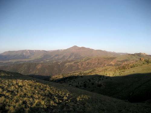
![View from Spout Springs]() The first goal: Eleven miles away from Robbers Roost
The first goal: Eleven miles away from Robbers Roost
Most of this part of the hike was out in the open as we gained the southwest ridge of Pat O'Hara Mountain and followed the Damnation Trail west towards Trout Peak. We found an old wooden sign with "Trout Peak Trail" written on it, but it looked like it had been pulled out of the ground a long time ago.
![Trail sign]() Trout Peak Trail sign
Trout Peak Trail sign![Trout Peak Trail]() On the trail
On the trail
After passing the unnamed spring just past this point, we passed through a couple of sparsely forested sections before finally reaching the pass at about 9800 on the northeast slopes of Robbers Roost Peak. The size and depth of the amazing views that kept on getting better the higher we went must be experienced to believe, as pictures don't really communicate the majesty and beauty that is found in the peaks and valleys of this Wilderness.
![Logan Mountain and Buffalo Bill Reservoir]() Just one of the vast views in the Absarokas
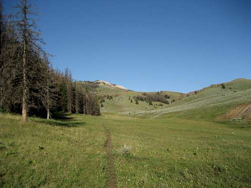
Just one of the vast views in the Absarokas![Climbing the slopes of Robbers Roost]() Jan hiking up the ridge on Robbers Roost
Jan hiking up the ridge on Robbers Roost
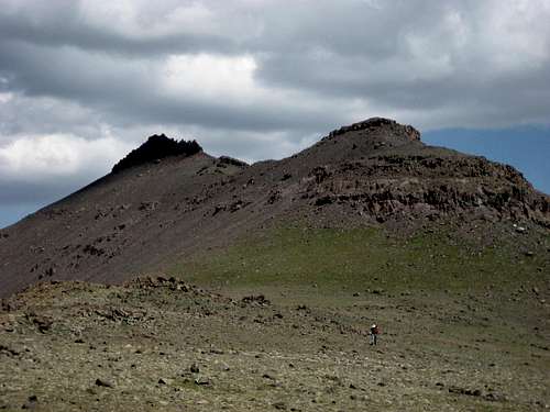
At this point we left the trail and headed up the lengthy grassy slopes of the ridge leading to the summit of Robbers Roost; after 2.5 miles and 2000 feet of elevation gain the rocky summit spine finally came into view, and we scrambled along the south side of the ridge to a point where we could scramble up to the top.
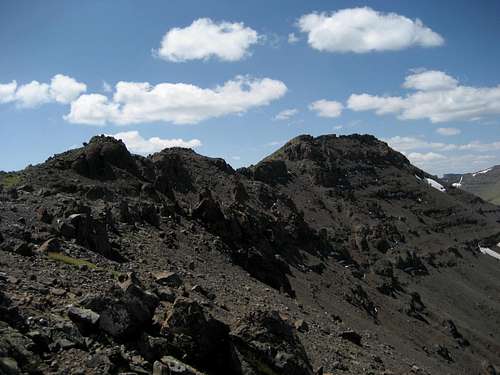
![Robbers Roost summit ridge]() The first view of the summit
The first view of the summit
This small summit features spectacular drop-offs on either side in addition to the already amazing views:
![The summit]() Robbers Roost summit
Robbers Roost summit![Jan on Robbers Roost]() Jan on top
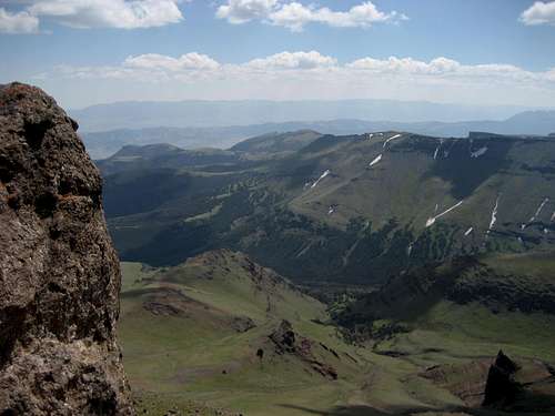
Jan on top![View south]() Summit view south from Robbers Roost
Summit view south from Robbers Roost

After signing the climber's log, we started making our way down to the saddle that connects Robbers Roost to Trout Peak. This required giving back about 600 feet while down-climbing some Class 3 rock sections, and the closer we got to Trout Peak, the more daunting its east face looked.
![Jan on Robbers Roost]() Down-climbing on Robbers Roost
Down-climbing on Robbers Roost![Robbers Roost]() Looking to Robbers Roost from the connecting saddle to Trout Peak
Looking to Robbers Roost from the connecting saddle to Trout Peak
By the time we reached the base of the face, it was about 2:00 in the afternoon. We happened to have absolutely perfect weather, which was a great thing considering that we were on exposed ridges from 10:00 in the morning until late the following morning!
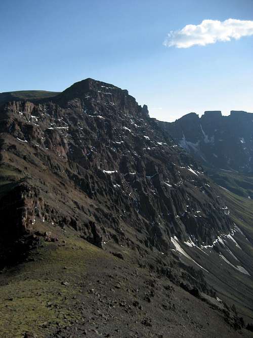
![Trout Peak summit block]() The east face of Trout Peak
The east face of Trout Peak
Once we started heading uphill again, it was obvious that the steepness, abundant scree, and generally awful breccia rock would make a direct route up the face a dangerous proposition, so we started looking for a route around to either the north or south ridges. While we later decided that going left would probably have been easier, it didn't look from that way from below, so we chose to head to the right and cross under the lowest band of rock (visible in the picture above) to try and reach the north ridge.
![Trout Peak summit block]() Looking up to the top from the dicey scree traverse
Looking up to the top from the dicey scree traverse
This was by far the trickiest part of the climb, as the ground was very unstable and the rocks to the side kept pulling out at the slightest touch; a slip here would have been tough to stop and would have resulted in a uncontrolled slide for over 1000 feet to the valley below. After almost an hour of carefully picking steps, we finally reached the ridge and turned south to climb the final 200 feet to the summit.
![Class 3 scramble]() The final climb to the Trout Peak summit
The final climb to the Trout Peak summit
There were a couple of steep Class 3 sections on good rock just below the summit, which we reached at about 3:45. We signed the summit register (only a half dozen entries in the last five years) and made a few phone calls before Jan headed down the south ridge in search of water and a campsite. I stayed on top for a little longer to take some more pictures and savor the fact that I was finally standing on top of a peak that I had dreamed of climbing such a long time ago - to get to do it on a perfect day with no wind was truly a magical experience!
![On the summit of Trout Peak]() Finally on top, fifteen years after first setting the goal!
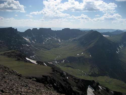
Finally on top, fifteen years after first setting the goal!![Summit view southwest]() Looking into Damnation Basin
Looking into Damnation Basin
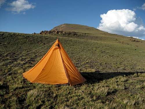
I descended about 500 feet down the south ridge and caught up to Jan, who had dug a hole and was filtering water under a snowbank. After filling up my Camelbak and his water bottles, he cooked macaroni and cheese for dinner, which was very good. We discussed the possibility of continuing along the ridge to Crag Peak after dinner, but decided against it because the terrain looked rough and we weren't sure there would be enough daylight left. We set up camp just above the snowbank and suspended our packs over a nearby cliff edge; there were quite a few rocks in the area that had been recently turned over by grizzlies, so we made sure that there was nothing too interesting with us in the tent!
![Camping just below the summit]() Camping a few hundred feet below the summit
Camping a few hundred feet below the summit
We watched a beautiful sunset and turned in at about 8:30. The night was a little windy, but was uneventful; the views of the last quarter moon and stars at about 2:30 in the morning were stunning!
![Sunset from Trout Peak]() Sunset over Mount Dewey
Sunset over Mount DeweyDay 3: One More Summit and the End of the Trip

Jan woke me up at 6:00, saying "We have daylight!" The view in the picture above of Crag Peak was the first thing we saw after climbing out of the tent in the morning, which was definitely not a bad way to start the day! We retrieved our packs and got back on the trail a little after 6:30. Negotiating the ridge proved to be more involved than it looked from above; while it was nothing like crossing under the rock band on Trout Peak, there were still some very slippery scree sections and some Class 2+ rock sections to cross.
![Morning rays of sun]() Early morning rays of sun
Early morning rays of sun
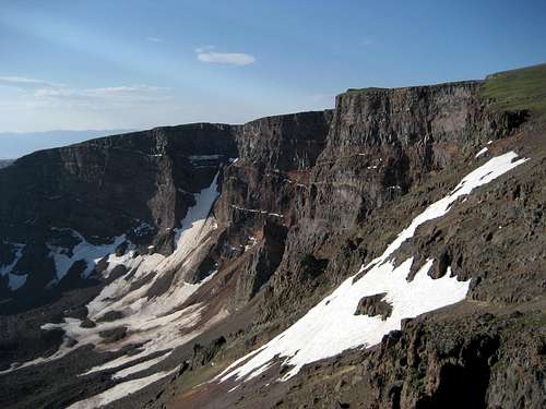
During this stretch we were treated to several low flyovers by the airplane from the Game & Fish Department, which was out counting grizzly bears on the ridges, as it was in the middle of army cutworm moth season. Once we were near Crag Peak, I went on ahead to tag the summit while Jan brewed himself a cup of tea in a little cove that was out of the wind. While this mountain doesn't have quite the appeal of the two we climbed the previous day because its summit is merely the highpoint of a broad plateau, the view down the northeast face of the peak into Damnation Basin and its jagged wall of pinnacles is definitely worth the trip.
![Crag Peak north face]() The northeast face of Crag Peak
The northeast face of Crag Peak![Glaciers]() Glaciers below Crag Peak
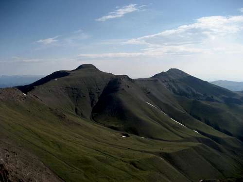
Glaciers below Crag Peak![Trout Peak and Robbers Roost]() Trout Peak (left) and Robbers Roost (right)
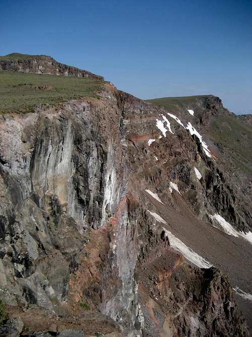
Trout Peak (left) and Robbers Roost (right)![Cliffs on the approach]() Large walls viewed during the walk along the ridge
Large walls viewed during the walk along the ridge
I met up again with Jan and we turned to the east and followed the ridge to the headwall of the massive drainage that contains the headwaters of the East Fork of Big Creek. While on top of the ridge, we saw lots of grizzly tracks, which paralleled our route for about a mile down the ridge.
![Small grizzly tracks]() Grizzly tracks at about 12,000 feet
Grizzly tracks at about 12,000 feet
After scrambling down to the valley past the large glacier that feeds the creek, we walked along the creek for two miles with walls gently rising for 1,000 feet above on either side.
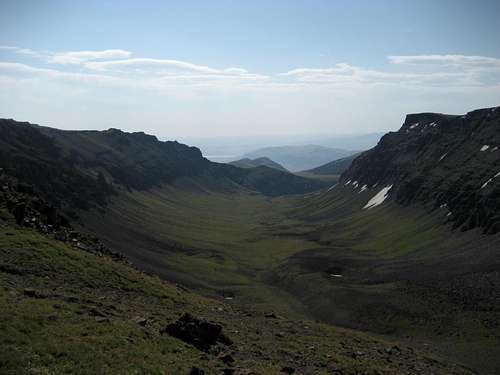
![Big Creek valley]() Looking down into the East Fork of Big Creek
Looking down into the East Fork of Big Creek![East Fork Big Creek]() The view back up to the headwaters of the creek
The view back up to the headwaters of the creek
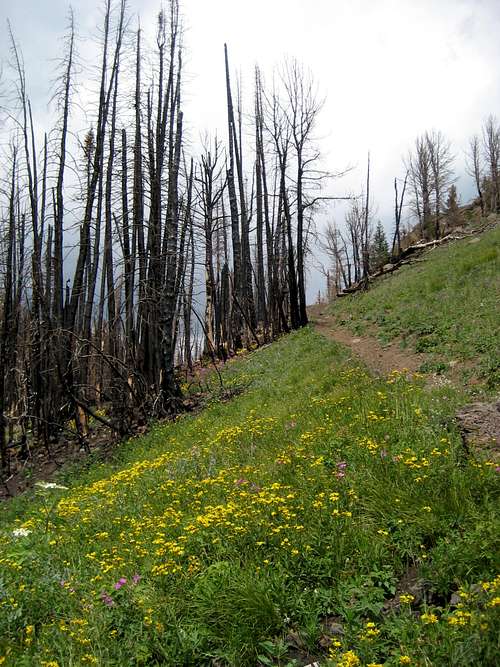
Following this section, we followed some game trails along the left side of the valley to the large meadows on the north side of Jim Mountain. We picked up the Jim Creek trail about halfway through the meadow, which led us down to the forest; the Gunbarrel Fire burned through here in August of 2008, and the abundant wildflowers in the blackened trees made for an interesting study in contrasts.
![Jim Creek Trail]() On the Jim Creek trail
On the Jim Creek trail![Falls on Jim Creek]() Falls on Jim Creek
Falls on Jim Creek
The remaining part of the hike was very long and hot, and it probably seemed longer because the views were limited to endless sections of burned trees! We ran out of water and had to stop and refill in Jim Creek in order to finish the final three miles to the truck; once we left the trees, the last stretch was in the open through sagebrush-covered badlands with nice views of the large rock spires that line the north side of the North Fork of the Shoshone River.

We got back to Jan's truck at about 2:00, and given the fact that we had been looking forward to a huge lunch at Arby's all morning, we made a beeline for the place and pigged out!
![Jim Creek Trailhead]() Jim Creek trail head
Jim Creek trail head
After driving back up the mountain to Spout Springs to get my car, we got back to Powell at around 6:30 to officially bring our adventure to a close. Jan and I are excited about getting back into the area next summer to do more peaks, as there are dozens of obscure summits out there that see few visitors and epitomize everything that is appealing about the North Absaroka Wilderness!

Conclusion
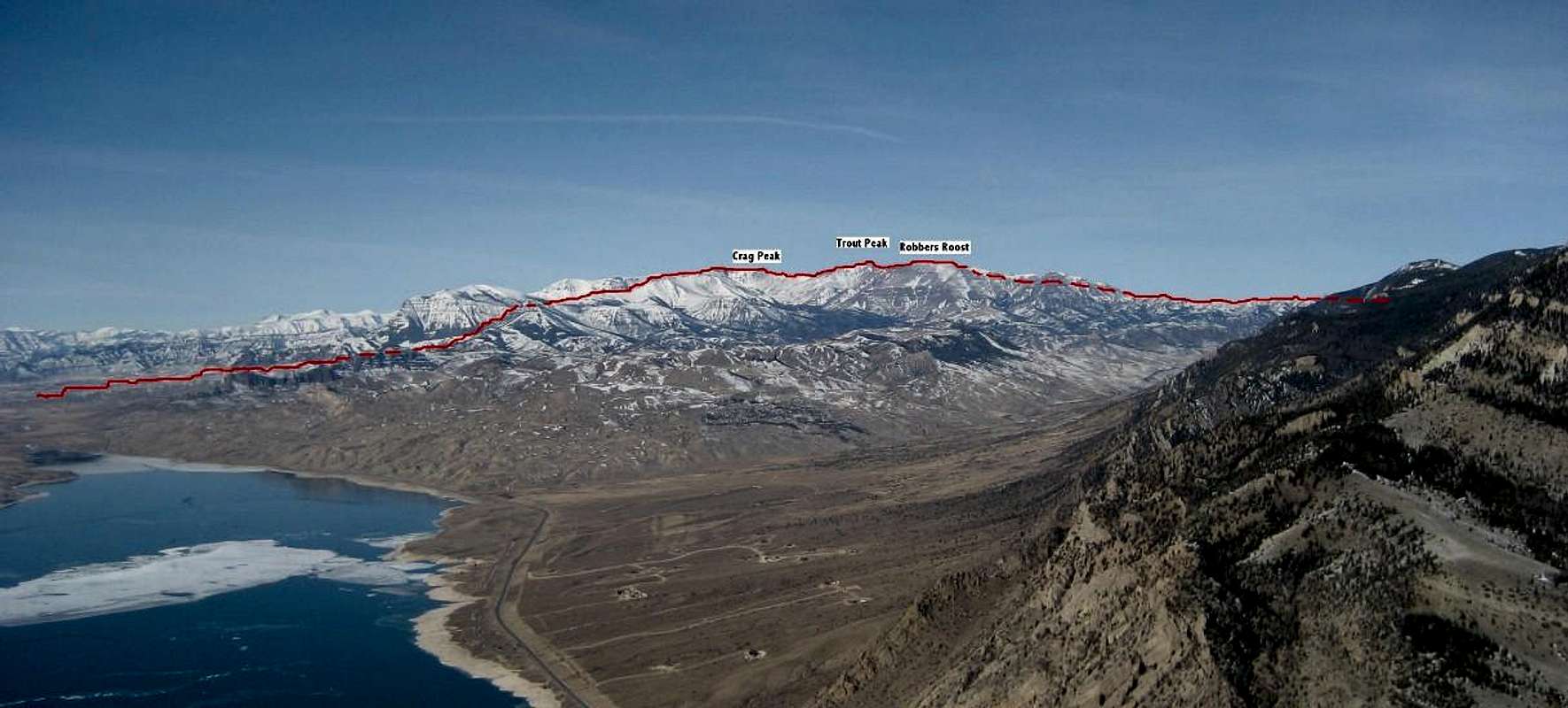
Over the entire trip, Jan and I climbed three of the highest 200 peaks in Wyoming and covered 25 miles of terrain with 5000 feet of elevation gain. Our route is shown from right to left on the picture below (taken early in 2009 from the summit of Cedar Mountain). To view a similar picture without the text and route, click
here.
To view the SP pages for the peaks climbed in this trip report:
Trout Peak
Robbers Roost
Crag Peak
Trout Peak traverse from Spout Springs to Jim Creek (right to left) |


Comments
Post a Comment