
-
 4839 Hits
-
 77.3% Score
-
 8 Votes
|
|
Mountain/Rock |
|---|---|
|
|
35.17002°N / 25.39967°E |
|
|
Download GPX » View Route on Map |
|
|
Hiking |
|
|
Spring, Summer, Fall, Winter |
|
|
5177 ft / 1578 m |
|
|
Overview
 Afentis / Αφέντης seen from the east Afentis / Αφέντης seen from the east |
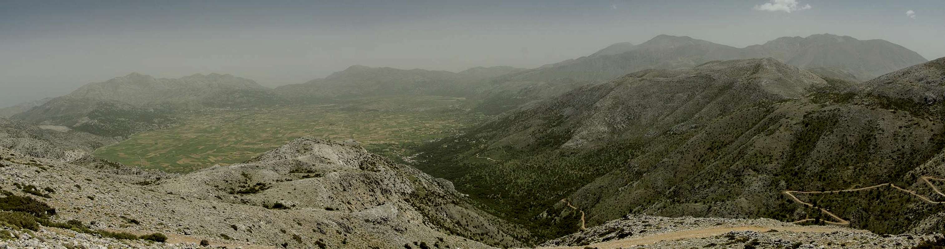
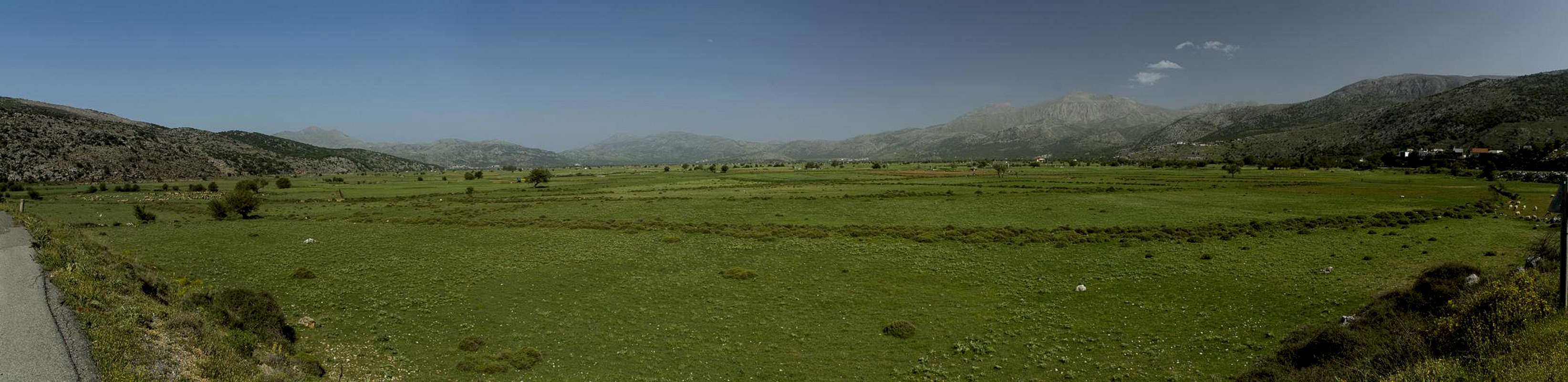
The Lasithi Plateau in the east of Crete is a nearly circular plain, surrounded by mountains. While the highest mountains are located in the south and reach more than 2000m (Dikti, Afentis Christos, Lazaros) the remainder of the surrounding mountains reach heights of around 1500m. To the east of the plateau there is a triplet of karst-like limestone mountains, Sarakinas (1588m), Afentis (1578m) and Moutsounas Toumba (1538m). The easiest and most popular summit of these is Afentis, located to the north of the other two.
There is an easy explanation for this popularity: a road, which reaches to the very top of the mountain. In former times it used to be a pilgrimage trail to the chapel on the summit, used for processions during the important celebrations of the orthodox church. Later, in the 20th century, a radio station was built close to the chapel, supporting the nearby NATO airfield of Kastelli (invisible on maps ;-)). Today the station is falling into disrepair while the chapel still holds out as it did for many years.
 |  |  |
Now, a mountain, accessible by road does not appear to be a worthy destination but there is a second, much more rewarding ascent route, which follows the long and broad east ridge of the mountain. Getting to the ridge requires some sfeats of orientation, as the whole mountain with its sorrounding areas is a typical karst formation. There are featureless limestone plateaus, sudden twoers, which block the way, an occasional perfectly circular pasture and lots of rocks. Moreover, vegetation like rock roses and low olive trees often bars the way and you will be forced onto tracks which lead into dead ends. But with a bit of luck and stamina you'll get to the ridge, from where your destination is right in front of your eyes.
 |  |  |
Thanks to the solitary location (solitary minus the two brethren summits mentioned above) Afentis is considered one of the best lookout peaks in the east of Crete. Naturally the Lasithi Plateau with its surrounding mountains draws most attention but the low plains to the west and the coasts to the east and south are plainly visible. In clear weather you will catch a glimpse of Crete's two other mountain ranges, Levka Ori and Psiloritis.
Getting There
  |
There are two international airports on Crete, both in the north of the island. One is at Chania in the west, the other is at Heraklion in the centre.
There are myriads of ferries in Greece, which connect the many islands of the country. Consequently there are many ferry harbours and Crete is no exception. However, most of the smaller harbours only cater for transportation to the other islands while the major lines to the mainland are reserved to two harbours, Souda near Chania and Heraklion. Both serve connections to Peiraias and Thessaloniki.
Afentis can be reached from two villages in the east of the Lasithi plain, Kato Mechodi or Plati, which are connected by a road of 5km length. The two routes from the villages connect into a long loop trail.
- To reach the trailheads you need to follow highway no 90 east from Heraklion.
- For the Lasithi Plateau leave the highway near Chersonisos and follow the signs for the Plateau.
- On the plateau turn west until a 90° bend (first trailhead) or on to the villages Kato Mechodi or Plati.
Routes
There are two easy routes up to Afentis, both of which start at the Lasithi Plateau. Both, however, require orientation skills, mainly because of man-made obstacles which attempt to push you off your tracks.Lasithi to East Ridge
 |  |  |
The first route follows the old Venetian Trade Road, which connects the Lasithi Plateau with Katsamonitsa in the west. It follows a valley, then heads up to a saddle, which is the nominal boundary of Lasithi. In the saddle there is a road crossing, where you leave the trade road for a modern road, which leads southward. Where the road bends back westward another dirt road leads southward. Follow this road until you get to an eastward bend. Here stay on a southward track which will lead you across limestone slabs into a circular plain underneath. In the west of the plain a barely visible path heads up to the Afentis east ridge. Follow the winding ridge to the top.
Plati to Afentis
 Terrassed fields, most of them abandoned on the valley route
There is a road from Psychro to Afentis, which is the easiest access to the mountain. However, a more beautiful though strenuous trail follows the valley between the road and the broad Afentis east ridge. From Plati follow the road which heads south-eastward out of the village. It soon ends in abandoned terrassed fields, which head up almost all the way to the saddle beneath the Afentis south face. Either hike across the fields or follow the old overgrown maintenance / mule trail to the right side of them. Eventually you will reach the Psychro Road, which you follow up to the summit.
Red Tape
 Looking down the descent Valley to Lasithi
Afentis is located to the west of Plathiani Lagkada, a small natural park. The usual restrictions should apply even though the radio antennas on the summit speak a slightly different language.
Accommodation
 |
You can quite easily find hotel rooms and apartments everywhere on the coasts. All European travel companies offer accommodation so a visit to your nearest travel office will find you some. In the mountain villages there always are inns and if everything fails you can pitch a tent.
There are abundant campgrounds along the coast and on many of the beaches you can pitch your tent. The touristic beaches in the north and the beaches in the vicinity of tourist towns are mostly off-limits but there is many a cove which you can use. In the mountains you will often find cattle (goat and sheep) fences which you should respect. There is many a green meadow in one of the plains but you should be aware that you’ll be woken up by goats. Again, in the vicinity of villages, rather ask the locals if you can use their land.
Weather Conditions
Maps & Books
There are quite a number of maps and books out there, which deal with the island of Crete and naturally I don’t know them all. This is the list of maps and books which I used and I appreciate it very much if you can add to itMaps
Unfortunately there are no decent topographic maps of Crete. The best maps I could find are scaled 1:100000 and contain the main hiking routes on the island. In one case the map showed wrong paths and roads (exchanged them) but in general they were quite useful. In any case they were better than the Anvasi Maps, also scaled 1:100000, which claim to be topographic maps but miss routes and even mountains
- Kreta / Crete / ΚΡΗΤΗ Western Part
Touring Map
1:100000
Harms Verlag
ISBN: 3-927468-16-9
- Kreta / Crete / ΚΡΗΤΗ Eastern Part
Touring Map
1:100000
Harms Verlag
ISBN: 3-927468-17-7
Books
Since there are no good topographical maps of Crete you should take care to get a good guidebook. The ones I used have good tour suggestions though the descriptions often are somewhat shortish and can be misleading. The books are available in German and English.
- Kreta Ost / Crete East
Gert Hirner / Jakob Murböck (translation: Gill Round)
Rother Verlag
ISBN:
978-3-7633-4004-0 (German)
978-3-7633-4822-0 (English)