
-
 3925 Hits
-
 70.83% Score
-
 1 Votes
|
|
Route |
|---|---|
|
|
40.49000°N / 111.696°W |
|
|
Canyoneering |
|
|
Spring, Summer, Fall |
|
|
Half a day |
|
|
5.6 (YDS) |
|
|
Overhanging and Wet |
|
|
1 |
|
|
Overview of "Ahab in Acid"
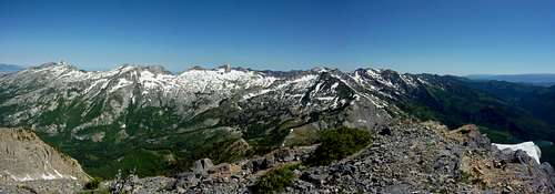
Let's start with this panorama: a fine reason to hike up to Box Elder! That's a lot of Wasatch Peaks visible.
Okay. I think I am all done. This page is meant to deter as much as inspire.
This is one of my accidental discoveries which came about from trying to shave miles off a descent hike. This route is only possible for a descent. Anyone who has ever made the loop up, down, or around simple Box Elder Peak has probably thought with annoyance that the trail does not need to go around Peak 10626 to the South to complete a full loop. Why not just take an Easterly descent through what looks from above like gentle canyon? (I have seen a trip report claiming a fairly easy descent of Eastern slopes, and a gully, which I expect was down the center of White Canyon where a snow coulour seems to linger (see photo below). So I am not the first or the last to try some imagination on this peak.) Especially if the trail is hidden with snow, this seems like an appealing design to the enterprising fellow. If getting lost, you might as well get lost on a direct short path, right? That was my thinking. Using a map with a 1:50,000 scale, I imagined I was descending White Canyon, but actually realized eventually that I was in Wide Hollow- a strangely named place, I can tell you, having hiked, climbed, and waded through 2+ narrow and sheer miles of the thing. Perhaps "Box Hellder Canyon" would give people a better idea what to expect. One can descend entirely from the summit of Box Elder to Granite Flat Campground in approximately 2 miles, coming out looking like a maniac or a half-dead goblin, or attempt to connect with the actual Box Elder Trail #044 around 9,000 feet elevation as it traverses North/South for a stretch East of Box Elder Peak's summit before swinging East/West (North of Wide Hollow) and descending to the shared TH area for Deer Creek and Box Elder Trails, which comprise a loop around the mountain.
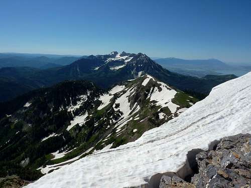
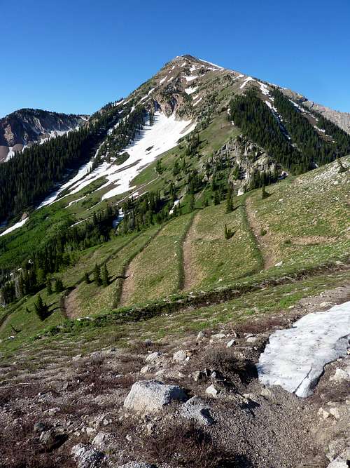 Box Elder Peak from the Box Elder Trail to the North (looking S). If you want to get creative on the descent, I suggest the snow near left of the summit cone- I have read of people claiming easy East slope descents by just forgetting there is a trail at all, and that is probably the line. I even thought this going up... | 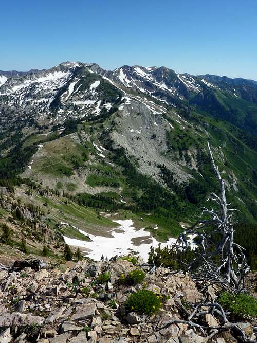 A view back down the off trail section (not maintained anyway) up the Northeast ridge to Box Elder Summit, after leaving the Box Elder Trail. All easy pleasant stuff down there. |
If you do not miss the trail crossing, which, after snow melts out, should be impossible to do (I say should because I did miss the trail crossing, which even under snow should be difficult to do- I blame a dead deer which distracted me, and which, knowing deer behavior, was likely walking the trail), then you will only be off trail for 1/2 mile or so, descending 2,000 pretty casual feet from Box Elder Peak and saving yourself around 3 miles of footsteps. If you do miss the trail, this is hardly a short cut, though you will save miles, while suffering all the horrors possible to a man within 5 miles of civilization in this modern world. I felt like a man being swallowed by a pissed-off whale with indigestion, and since I thought I was in White Canyon, Captain Ahab and Moby Dick came to mind. The name fits because this is a wet, cold ordeal that can leave you burning with fever and infected cuts for weeks. And it will be an ordeal, because an ordeal is something you endure while an adventure is something you enjoy, even a little, at all times. But it is a fond memory now, and it made me stronger and I learned some lessons which I will never forget (even after I destroyed most of the pictures- what is the evil twin and polar opposite of nostalgia?).
Now, there are only a few reasons why anyone would want to attempt this route or even read further and if none of these fit you, then do not even eyeball this route from a helicopter:
A) You have a wish to die where no one will find your body for months
B) You are a masochist and enjoy pain, or need life to be hard because you hate yourself and think you are a bad person who deserves to suffer and are hoping penance will make Jesus, Allah, Vishnu, Robo-Buddha or whoever you pray to go easier on you in the next life (and because you don't know how to knit a Dark Ages hair shirt)
C) You are studying the original 1830s Mountain Men and wonder just what they really went through every day
D) You enjoy doing hard things for the sake of their being hard, and think this builds character, or makes you appreciate life, food, wine, women (or men), and song more deeply
E) You are training for a trip to the Pickets, Missions, or some other trail-less wilderness known for breaking the greatest mountaineers in the world and are worried you will wind up crying like a dumped school girl and throwing your pack off a peak in frustration if you don't get some bushwhack experience closer to home first
That last one is probably the most likely realistic inspiration, and its not bad thinking. If you can get through Wide Hollow in one piece, you'll know you can take a lot and you'll know how you respond to adversity and danger and having hours and miles between you and any escape or relief.
Getting There
Take your favorite trail to the summit of Box Elder Peak. May I suggest Deer Creek Trail to the Northeast Ridge, so you can make a loop of sorts all without the need of a car shuttle? See the Box Elder Peak main page for more information. No need to repeat it here.Route Description
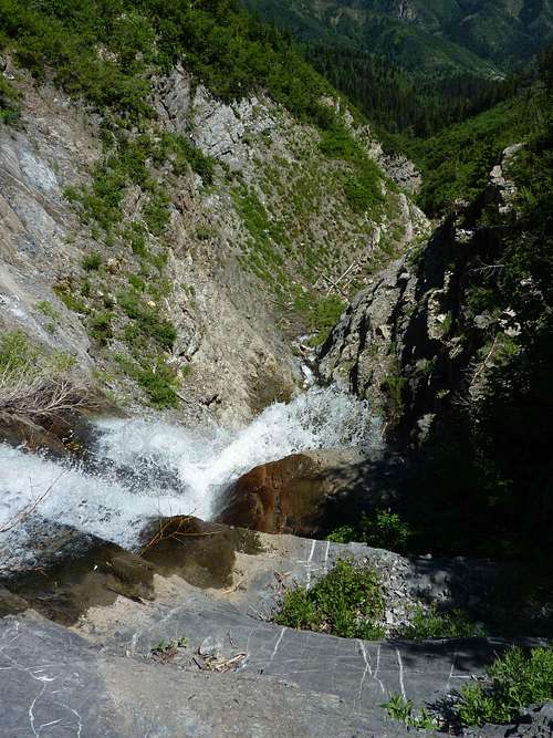
From the summit of Box Elder descend the climber's "trail" as far as you like, or until snow hides any further sign of previous human travel. Break East at any point, aiming slightly South. You are following the creek that cut out Wide Hollow. Things are easy for a while, likely on snow in early season. Keep in mind that the trail crossing is somewhere around 9,000 or 8,900 feet elevation and may be under snow. If the terrain has gotten tough, or you have come to the first waterfall, you missed it. Now you can either retrace steps and look more carefully, or go down to the right (South) of the first short waterfall. The cliffs will be wet from splash and spray but are solid for hands and feet and only about 10 feet high. But from this point on, there is no return.Wide Hollow closes in. There are soon thick and bushy slopes on both sides. You will work around 5 waterfalls. The first we just covered. Another required a bushwhack of 300 feet to the right (South) through short trees. I never touched ground as the trees were so thick. You will come to a gully that descends through them, though steep and precarious. Be careful of loose rock. The brush is always sharp around every obstacle. A longer and more dedicated bushwhack through similar trees (which I think are mountain willows) to the North at any time up steep awful looking slopes could potentially reach the ridge and then descend through similar horror to the real trail, but I never thought of this seriously at the time as the idea was so terrible. The biggest of the falls is the third, if memory serves, which stands around 50 feet or so and is the crux of the climbing. The cliffs all around are overhanging, and covered with brush. There are no good spots to climb. I navigated left, to the North side of the creek to where a dead, upside-down, decaying pine tree had lodged against the cliffs from what was likely an avalanche. I was able to downclimb the tree, using branches for my feet and handholds, though near bottom, these gave way and I slid down the trunk to wet rocks below. This tree was a lucky find for me as I had no rope and was alone. There truly is no turning back from this point. The last of the falls has no work-around. It is really just a minor rapid where water tumbles over steps of jagged rocks, but with nowhere to go on either side, you will have to just "downclimb" it, clinging to rocks, or letting go, and hoping your waterslide does not break any bones. I opted for this last option because I was spent and could barely care by then.
 The actual trail wraps around this mountain partly obscuring Timpanogos and friends in the background. You can perhaps see why some of us decide there must be a more direct way down. | 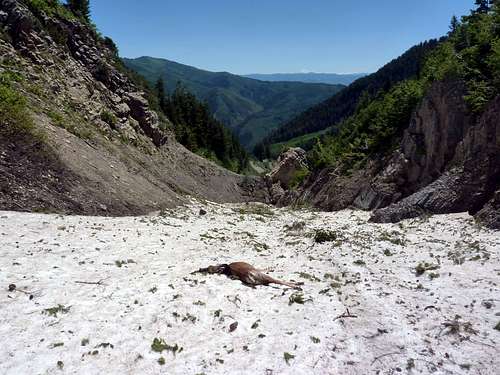 The trail ought to cross obviously around here, or somewhere just below, but I was already wondering if I missed it at this point, and was trying to decide if this deer had gotten stuck and if I was about to as well. | 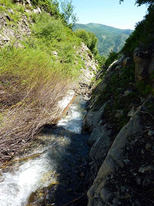 Maybe I should have turned back around here, but I'm a stubborn, stubborn man. |
 One of several spots where a rope may provide comfort. | 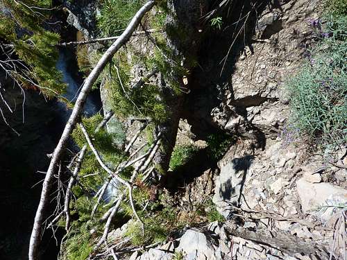 My fortuitous tree that I had to climb down. I took this picture to commemorate my last view in this life if I fell. Aren't you impressed that I STILL did not turn around at this point when I could have? | 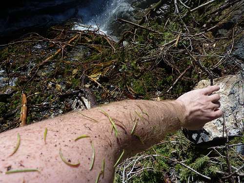 Debris from the tree after some branches broke and I slid down the last few feet. Sorry but in the trauma aftermath I deleted all the rest of the pictures of the route, never thinking I'd have a spot for this story. If you've ever been waste deep in a creek, or walked face first into a thorn bush or a spider's web you can imagine the view I had for the next 90 minutes. |
The final mile, or probably a little over, starting before the last falls/rapid is so overgrown that you will be wading the creek. This is actually not the worst result on a hot Utah summer day, as at least you will not die of heat stroke, but branches and spiderwebs, and stinging nettles, thorns, stones, and more block progress. The creek is narrow and never over waist high, but footing is slippery, progress painfully slow. There is never a shore or any hope of dry footing. Getting out on either the North or South is worse than staying in, though at times to get around barriers, you will need to step around and over.
The creek goes right past Granite Flat Campground. Pay attention so as not to miss it or you will really be miserable. But my 6th sense tingled suddenly as I just knew to step out of the creek, and 5 feet away were a couple of people fishing, looking like Sasquatch was upon them. My car was mercifully not far away at that point. If you need more details, don't take this route. Actually, don't take it unless you fit the 4 reasons I mentioned above. It will make you tougher and there is unlikely a more arduous mixed bushwhack in this world that a man can come out of alive in a single day, but its an awful time, and you could not pay me to do this route a second time. Actually, you could, but it would have to be a lot.
Essential Gear
I whole-heartedly recommend a friend or two and a rope. Having someone to sob to or howl in frustration with will really improve your outlook, and there was the one waterfall to navigate with overhanging cliffs and the dead, upside-down, decaying pine tree. If that pine is gone, or broken by now, you will need to create an anchor and rappel this one section. Bring shoes and clothing you do not care about and wear pants. There are stinging nettles and poison oak (I think) in the creek, and during the wade any open cuts or sores will become infected and itch for weeks, even with ointments. I have gone through this and it almost made me mad not scratching. Crampons are advised before August, and an alpine axe. A machete or bowie knife will probably be helpful in a few places (and no one ever needs to know. Its just between us.) Plenty of food for a whole day, emergency bivy gear for if you get stuck overnight (though you would be sleeping on awful ground if you could even find any ground to lie on), a Bible or other comfort toy, and if you are truly concerned about your merits and fortitude, a cyanide pill or two might be wise.I kid on that last one. But pack for an overnight trip and bring a filter or water treatment of some kind. I was packed for a half day- all on trail I thought- and was tragically unprepared for what I got into, resorting to scooping fingerfuls of the creek I was in just to wet my mouth enough to not go crazy in the heat and keep on my feet. I was in sorry shape when I exited. That is the point with this one, but don't be the idiot who dies on Box Elder Peak. No one who does the loop trails will ever understand how you could have managed it. And if you disappear, no search and rescue person will suspect Wide Hollow swallowed you up until its too late. Its a lonely and a hideous place to die, and I don't need you cursing my name and this Summitpost page with your last thoughts as you do.