When Antonio came to ask me information about the Aiguille Verte de Valsorey I gave him a wrong exclusively at my memory and without consulting my personal record (where, once, I kept the reports of all my trips with the relative ascents, trails or paths, the various companions and the dates) and then published he by opening the page on March 31, 2011, where in "First Ascent" was read :
N-NE Crest Integral Route: Osvaldo Cardellina and Luigi Gadin, (Jul 02th, 1981), in ascent and in descent.
But when the "Gigi" came to see me at home, he immediately noticed the error: we did not actually use the same route downhill, but we had first descended on the end of the South-South Crest and then enough through the steep Eastern Face. This is the goal to reach the base of the Glacier de By, for then reconnect to the approach to the coming from the little valley where flows the Torrent de la Clavette, adjacent to the West of the Comba Farinet, both above the very large By Basin. When I went to see my personal register, I had to admit the error, which was then corrected on September 17, 2017. Ahi's memory! Otherwise, it had been a long time since June 30, 1981, when, during the very very boring examinations at School, we organized the tour. Time is inconceivable, but it is true that the Latin saying that "Verba volant et carta cantat ...", that is, the words fly away while what has been written remains. At least that ...
N-NE Crest Integral Route: Osvaldo Cardellina and Luigi Gadin, (Jul 02th, 1981), in ascent.
S-SE Crest (last part) and directly on East Face: Osvaldo Cardellina and Luigi Gadin, (Jul 02th, 1981), in descent.
Quando Antonio é venuto a chiederni informazioni sull'Aiguille Verte de Valsorey gliene ho dato una errata, a memoria e senza consultare il mio registro personale (dove, una volta, tenevo le relazioni di tutte le mie gite con vie percorse, compagni e data), e poi da lui pubblicata aprendo la pagina il 31 Marzo 2011, dove in "First Ascent" si leggeva:
N-NE Crest Integral Route: Osvaldo Cardellina and Luigi Gadin, (Jul 02th, 1981), in ascent and in descent.
Ma quando il "Gigi" é venuto a trovarmi a casa si é accorto subito dell'errore segnalandomelo: in realtà non avevamo utilizzato in discesa il medesimo percorso, bensì eravamo discesi dapprima sulla parte terminale della Cresta Sud-sudest e poi per l'abbastanza ripida Faccia Orientale. Questo per raggiungere la base del Glacier de By per poi ricollegarci all'avvicinamento effettuato all'andata arrivando dal valloncello dove scorre il Torrent de la Clavette, adiacente ad Ovest di quello della Comba Farinet, entrambi al di sopra alla veramente vasta Conca di By. Allorché, andato a consultare il mio personale registro, ho dovuto ammettere l'errore, che poi é stato corretto il 17 Settembre 2017. Ahi la memoria! Daltronde era passato molto tempo da quel 30 Giugno 1981, quando, durante i noiosissimi esami a Scuola, avevamo organizzato la gita. Il tempo é inclemente, ma risulta vero il detto latino che: "Verba volant et carta cantat ...", cioé le parole volano via mentre ciò che é stato messo per iscritto rimane. Almeno quello ...
N-NE Crest Integral Route: Osvaldo Cardellina and Luigi Gadin, (Jul 02th, 1981), in ascent.
S-SE Crest (last part) and directly on East Face: Osvaldo Cardellina and Luigi Gadin, (Jul 02th, 1981), in descent.
The two true Routes made
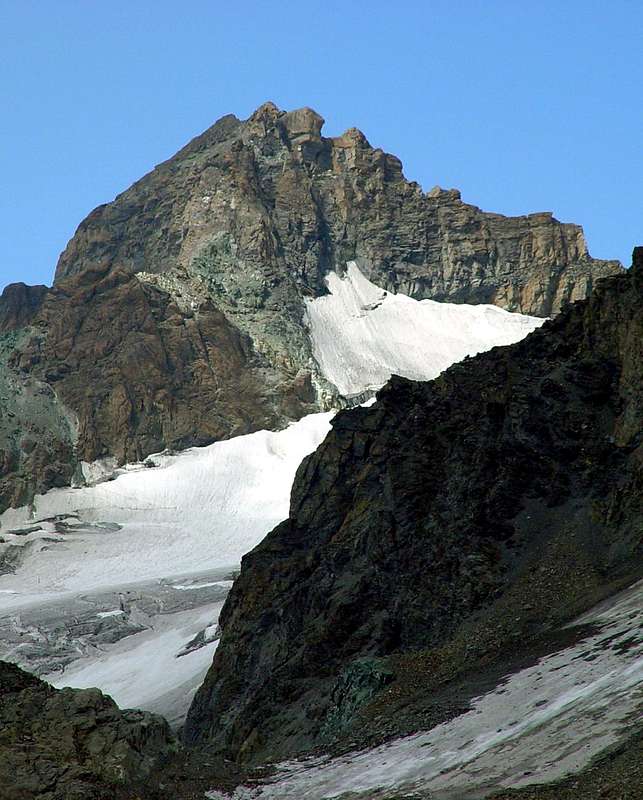
In foreground partial view of the Southern Slopes of Great Tête By's (3588 meters) towards Aiguille Verte of Valsorey(3489m) and from right to the left (West): of the Sphink Pass (3430m around), Les Luisettes (3443m) with the "Collar" of Mont Percé (3353m), the Grand Carré (3335m), the Rateau (3274m) and finally towards the five Molaires de Valsorey (3230m; occulted & preceding the Northern ramparts of Mont Velan 3734m; in background to extreme left);
Aiguille Verte of Valsorey with SW Face, S-SE Crest, E-SE Wall, NE border Ridge with the Quota 3431m from the Vert Pass (3395m; in the middle of the picture and between Aiguille Verte de Valsorey Grand Tête de By) or beginning of the Standard Route on the Northeast Crest of Aiguille Verte de Valsorey.
In middle and in bottom: the Glacier of By (left or West), among Aiguille Verte of Valsorey, Mont Sonadon (3578m), Great Tête of By (Little Head of By (3288m) and Garrone Point (3290m) and the Glacier of Amianthe or Amiante below Southern Face of Grand Tête de By. The descent follows briefly the left crest, or the South-South Crest, then down vertically on the left margin of the wall in full shade and the left margin (looking at) of the By-The-Glacier (East-Southeast Wall).
In primo piano vista parziale della Faccia Meridionale della Grand Tête de By (3588 meters) in direzione dell'Aiguille Verte di Valsorey(3489 m) e da destra a sinistra (Ovest): Passo della Sfinge (3430 metri circa), Les Luisettes (3443 m) con il "Collare" del Mont Percé (3353m), il Grand Carré (3335m), Le Rateau (3274 m) ed al termine in direzione dei 5 Molaires de Valsorey (3230 m; nascosti nonché precedenti le grandi bastionate Settentrionali del Mont Velan 3734 metri; in fondo all'estremità sinistra);
Aiguille Verte of Valsorey con il Versante Sudovest, la Cresta Sud-sudest, la Parete Est-sudest, la Cresta di frontiera Nordest con la Quota 3431m dal Col Vert (3395m; nel mezzo della foto e tra Aiguille Verte de Valsorey Grand Tête de By) ovvero all'inizio della Via Normale sulla Cresta Nordest dell'Aiguille Verte de Valsorey.
Nel mezzo ed in basso: il Glacier di By (a sinistra od Ovest), tra l'Aiguille Verte de Valsorey, il Mont Sonadon (3578 m), Grand Tête of By (3288m) e la Punta Garrone (3290 m) ed il Glacier d'Amianthe o di Amiante posto alla base della Faccia Sud della Grand Tête de By. La via di discesa segue per breve tratto la cresta di sinistra, o Cresta Sud-sudest, per poi scendere verticalmente sul margine di sinistra della parete in piena ombra ed al margine sinistro (guardando) del Ghiacciaio di By (Parete Est-sudest).
Parents refers to a larger category under which an object falls. For example, theAconcagua mountain page has the 'Aconcagua Group' and the 'Seven Summits' asparents and is a parent itself to many routes, photos, and Trip Reports.