"... Rakitnica River is 32 km long, while the surface of its orographically defined river system is 207 km2. Along 23,5 km of length, it flows through the canyon-gorge valley at the contact of folded block-thrusted massifs – Mt.Bjelašnica and Mt. Visocica. Upstream from the canyon part of the valley, the surface stream network is developed, with shallow riverbeds and relatively small inclinations of the valley sides. It occupies much wider surface and has greater stream network density compared to the canyon part, thanks to the domination of impermeable Jurassic-Cretaceous flysch.Canyon part of the valley has completely different lithological and morphological characteristics. Triassic limestones, dolomites, and dolomitic limestones, particularly fissured, prevented the development of surface stream network. Apart from the allogenic river Rakitnica, there are only two short permanent streams, several km long – Rijeka and Medjedja. Karst springs in the canyon contribute most significantly to the flow of the Rakitnica. On highly uplifted fluviokarst levelled surfaces on Mts.Bjelašnica and Visocica, into which the Rakitnica is incised, there are karst blind valleys.
The canyon-like part of the Rakitnica valley occupies the area of 54 km2, or 26,3% of its entire basin, if it is defined by surface orographic watershed.Three geomorphologic sub-sectors can be distinguished in this relatively small area. The upper sector of the studied part of the valley is a lithological and partially a morphological and structural unit, along 3 km of the river course. Hypsometrically, it is the highest part of the researched area, composed of Jurassic-Cretaceous clastites. This part of the valley is consequent, directly related to the geologic composition. Its morphostructural border towards the central part of the researched area is defined by the fault zone G.Lukomir – Brvanjske stijene. The central sector occupies the largest area, along 14 km of the Rakitnica course. This part of the valley is remarkably composite, polymorphic and exceptionally vertically dissected due to neotectonic movements. Downstream from the Dubocani – Grušca fault, there is the lower sector of the valley, the final 7km of the Rakitnica course until its mouth to the Neretva River. It has a distinctive sharp bend, and longest portions of extremely narrow vertical-sided parts (even with 1,5 m of width).
......
The longitudinal profile of the riverbed is discordant, with numerous steps which reach the inclinations of 80‰. Denivellation from the beginning point of the upper sector riverbed (1107 m a.s.l.) to the mouth to the Neretva River (324 m a.s.l.) is 800 m at the length of 23,5 km. Average riverbed inclination is about 40‰..."
Alen Lepirica: Basic morphological and morphostructural characteristics of the Rakitnica canyon (Dinaric karst, Bosnia and Herzegovina)
more
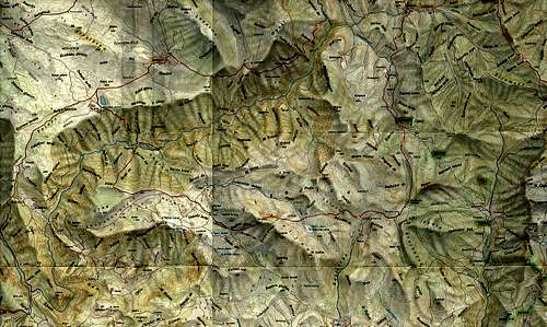
![Map of Rakitnica]() Map of Rakitnica canyon
Map of Rakitnica canyon
Rakitnica is small river full of wonders, thanks to long fight (not so long for river itself, it's young one) between water, which is trying to find it's way, and rocks which are trying to strangle it by falling down or tightening almost to touching each other. Canyon of Rakitnica has very dangerous enemy, people who have intention to ruin it by building roads for unmerciful forest exploitation and by building dams on upper flow of Neretva.
Rakitnica canyon is pretty wild and lonely place and some of the most beautiful parts are hard to be accessed. Anyway, it offers a lot of hiking and mountaineering, enjoying in floating down it's final section, or even extreme adventure of passing canyon all along by river in three days (but there are only few of those who did it).
It offers, but, one has to have in mind that hiking into canyon means no marked routes through woods, with often fainting paths. Sure, not recommended for those who are first time there to do it alone.
There are few bridges in canyon on paths connecting villages with other side.
The most visited is canyon side hiking path on Bjelasnica, from near Umoljani to Lukomir (2h). It is not demanding and is easy for orientation (clear trail or piles of stones marks). From Lukomir there are path for Cuhovici (1 hour), Blaca (2 hours) ... This villages are accessible by dirt roads (except during the winter).
Another easy, but enjoyable path is from hanging bridge on Neretva (by road Konjic - Glavaticevo), which leads to Kasici - bridge on Rakitnica – mouth of Rakitnica into Neretva.
If one wants to enjoy one day trip down Rakitnica, from Dubocani to bridge in Kasici, it's possible in organization of extreme sport club which obtain all necessary equipment and experienced guides.
Approach to the beginning of canyon is more than easy. Villages Umoljani, and Bobovica are accessible by car from Sarajevo. From near Umoljani in half an hour (and from Bobovica, on opposite side, even less), one comes to beautiful view down the canyon.
![Rakitnica]() View on the beginning of canyon
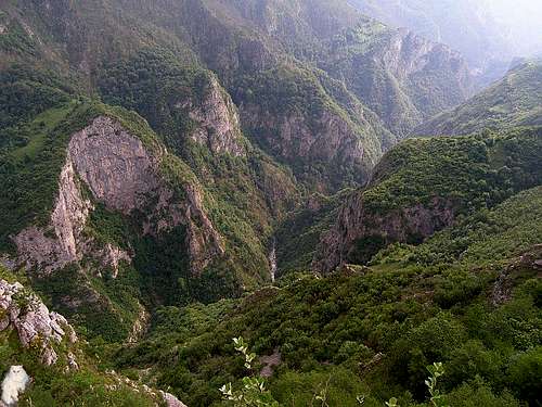
View on the beginning of canyon![Rakitnica canyon]() Part of central section of canyon
Part of central section of canyon![Rakitnica canyon]() View on last section of canyon
View on last section of canyon![Rakitnica]() Rakitnica on it's last kilometer
Rakitnica on it's last kilometerExternal Links


Comments
Post a Comment