
-
 20456 Hits
-
 82.48% Score
-
 15 Votes
|
|
Mountain/Rock |
|---|---|
|
|
49.73756°N / 125.49176°W |
|
|
Hiking, Mountaineering |
|
|
6503 ft / 1982 m |
|
|
Overview
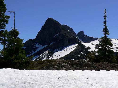 Alexandra Peak north aspect Alexandra Peak north aspect |
Alexandra Peak south aspect
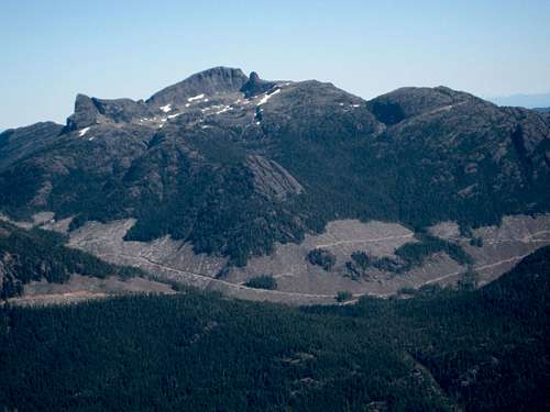
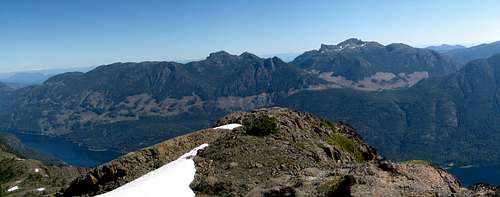
Situated approximately 40 km due west of the east coast town of Courtenay, Alexandra sits in the crook of land where the Oyster River deviates from its north/south course south of the massif and turns west up to its headwaters in lovely Pearl Lake. The western slopes of the mountain drop precipitously into Buttle Lake nearly 1,700 metres below.
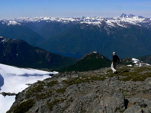
Alexander’s considerable height (ranked # 20 on Vancouver Island) provides the climber with 360° views across almost the whole of Strathcona Provincial Park and beyond, as well as views down the length of Buttle Lake and east to the Strait of Georgia and the mainland mountains of the Coast Range. From across the Oyster River Valley Albert Edward continues to smile upon Alexandra from a distance of ~ 8 km.
 Original 1934 survey bolt Original 1934 survey bolt |  Modern witness monument Modern witness monument |
Those who have the misfortune not to live on Vancouver Island might be surprised to learn that the mountain is not in any park and enjoys no protected status whatsoever. The mountain sits entirely on private land owned by the Timberwest Corporation. Logging reaches far up all accessible sides of the massif and stops only when the limit of practicality is reached or at the border of Strathcona just west and south of Pearl Lake. As a result of this unfortunate state of affairs, access to Alexandra is often at issue. Refer to the “Getting There” and “Approach” sections below.
Alexandra Peak west aspect
In spite of these imprecations, Alexandra is a fine objective with wonderful character and astonishing views. Providing the access roads are open and navigable, it is also an increasingly popular spring skiing destination.
Alexandra Peak east aspect
Getting There
Vancouver Island can be reached directly by air from Toronto, Vancouver, Seattle, Calgary, Edmonton and recently from San Francisco to either Victoria, Nanaimo, Comox or Campbell River and by ferry from Port Angeles to Victoria on The Coho and on BC Ferries from Vancouver to Victoria or Nanaimo. Public transport on the Island is notoriously poor and anyone arriving by air would be advised to rent a car.The approaches to Alexandra Peak require you to negotiate steep, narrow industrial roads that have or are being used to log the surrounding mountainsides. Whereas a normal 2WD sedan might reach the access point from the Oyster River to the southeast, the western approach requires a high clearance vehicle with 4WD and experience with difficult off-road driving.
Closed gates and/or limited hours of access are frequent occurrences. Before you go contact Timberwest in order to determine the best plan of attack and current conditions on the approach to Alexandra.
Approaches
Approach the mountain from the south on the Inland Island Highway 19.Oyster River Approach
For the Oyster River route, turn of the highway at Cranberry Road approximately 23 km north of the well-signed junction for Strathcona Parkway & Mt Washington Alpine Resort.
Drive west on Cranberry Road to the staffed gatehouse at the beginning of Timberwest’s Oyster River Main private road. Assuming you have arranged access, drive Oyster Main approximately 28 km west and then south to the south end of Norm Lake. The road then turns west once more and in about 2 km reaches a parking area primarily used by people visiting Pearl Lake but from which the southeast ridge of Alexandra may be reached. Starting elevation is about 850 metres.
Buttle Lake Approach
Proceed north beyond Cranberry Road. Reach Campbell River at the end of the freeway section of Highway 19 and take highway 28 west towards Gold River. After 47 km you will enter Strathcona Park at Elk Portal. Exactly 1 km further on highway 28 makes a right turn over the bridge at Buttle Narrows. Ignore the turn and carry straight on down the paved Buttle Lake Parkway (also known as Westmin Mine Road) for ~ 10 km and find “Buttle Bluffs Road” on the left at N49 45.899 W125 35.048 – about 400 metres south of the Lupin Falls day use area.
West side approach roads
Keeping right and/or uphill at any junctions, drive the steep and narrow road about 7 km southeast and up to the junction of two high hanging valleys with logging roads everywhere. One branch of the valley turns southeast down towards Pearl Lake and the other northeast, up towards the high pass between Alexandra Peak and Mt Adrian from where Alexandra Creek drains the mountains east and down to the Oyster.
 Washout in upper valley I Washout in upper valley I |  Washout in upper valley II Washout in upper valley II |  Right hand valley roads Right hand valley roads |  Left hand valley roads Left hand valley roads |
WARNING
“Buttle Bluffs Road” is not for the faint of heart. Particularly in the upper reaches it’s extremely steep, narrow due to rockfall and is beginning to slough off in places. Don’t try to drive it alone. A “spotter” is essential to guide you through some spots which were just wide enough to get my 4Runner through with the near side wheels on the last few inches of road overhanging the 1,000 metres drop to Buttle Lake below.
Summary of Summit Routes
SE Ridge
Attains the SE ridge via a flagged route from Pearl Lake parking. Follows the forested ridge up to the alpine where it joins the west ridge/bowl route on a shoulder just below the south satellite peak known as the “Thumb”.
West Ridge/Bowl
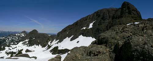
Reaches the west bowl under Alexander’s summit cliffs either directly off Prk 300 up the main gully draining the bowl (early season on snow) or via a steep bushwhack up to the west ridge and along the ridge until it peters out in the bowl.
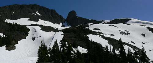
Alexandra Peak west bowl
Once on the shoulder south of the summit block both routes traverse the east side of the Thumb to a notch and up to the top from there.
Red Tape/Safety Considerations
Although there are no fees to pay or forms to fill in, a pre-trip conversation with Timberwest regarding access might be in order.As of July 2010, the current situation is as follows:
Oyster Main. Access open 6 am to 6 pm. No overnight camping, so you have to reckon on a fast moving daytrip. However, I have heard of parties making special arrangements to camp en route. So call TW and turn on the charm.
Buttle Lake. There is a gate but no gatekeeper. Day to day opening. I have heard of folk going this way and getting locked in. We were able to gain access, stay 2 nights and exit without problem. Two days later the gate was locked.
The summit of Alexandra looks right over to the towns along the east coast and subsequently we enjoyed full cellular service (Telus) once we attained the south shoulder.
On the summit of Alexandra Peak
This is private land and there’s nothing in the way of an intentions system. Make sure, therefore, that you have left a detailed trip plan with someone responsible. The RCMP and the appropriate SAR agency will respond in an emergency but it is up to you to have the mechanism in place that will initiate the call-out process if it becomes necessary.
Camping
If you approach via the Oyster the likelihood is that you will not be allowed to camp. Alexandra Peak Camp |
Light no fires and, since giardia is well documented on the Island and since you’ve brought a vehicle this far, include a barrel of water in your supplies.
Weather
Nearest point forecasts:East:
West:
Useful Links
For more information refer to Island Alpine – A Guide to The Mountains of Strathcona Park and Vancouver Island, Philip Stone, Wild Isle Publications, 2003, ISBN 0-9680766-5-3For general backroad information and directions get hold of a copy of Backroad Mapbook. Volume III: Vancouver Island
Don't go on any Island trip without checking out Lindsay Elms excellent Beyond Nootka website. There's a new section in there on Alexandra Peak with lots of fascinating historical photographs.
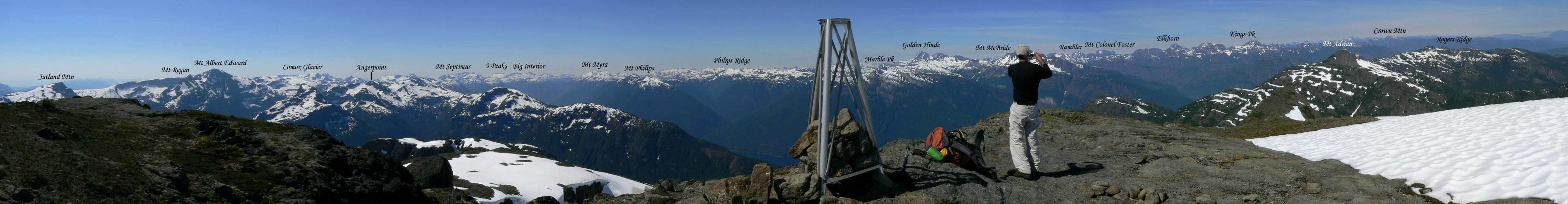
Summit Panorama
  |