The Alta Peak Loop
![Alta Peak]() Alta Peak from above Merthen Meadow (16-09-2008)
Alta Peak from above Merthen Meadow (16-09-2008)
During our 2008 US stay I intended to explore Sequoia and Kings Canyon NP for about three days to have a good first impression of this wellknown and widely recommended National Park. We went to Kings Canyon (which was more a “driving day” but impressive), we hiked through the Sequoia groves (
see my album), climbed Moro Rock and had some bear encounters in the woods.
Planning this stay I discovered Alta Peak summit as a promising and interesting day hike. As there was one day left we decided to try another Sierra summit. So on september 17th we left our motel at Exeter early, drove up to the NP and parked the car at Wolverton parking area to start our ascent on the Alta Peak Trail via Panther gap.
The weather forecast said something about a cloudy day with a good chance of thunderstorms in the mountains but I did not believe it - we had experienced three weeks of perfect summer weather and in the evening there was no hint of bad weather in the skies.
Alerted by our bear encounters two days before we emptied the car completely and began the ascent through the dense woods near Wolverton. There were many bear pawn imprints (and probably bear droppings, too) to be seen but no other bear came into sight.
![Alta Peak]() Indian Paintbrush(16-09-2008)
Indian Paintbrush(16-09-2008)
The trail alongside Wolverton Creek winds through sometimes dense wood and we were soon standing at Panther Gap, the col between Panther Peak and Alta Peak with a first good view to the mountains and peaks of the Great Western Divide. A rather strong wind was blowing up there and first clouds were rising into the skies above the summits of the High Sierra. They were growing quick and soon, while we were traversing the south slopes of the western Alta Peak ridge, huge parts of the sky was covered with grey and black clouds.
But our mood was still high. There were late wildflowers blossoming near some creeks coming down the south slopes and the views were just great. Near Merthen Meadows we had a little break eating a power bar and – experiencing some first drops of rain.
But soon enough the sun came out again and enlighed the final summit ascent.
I liked this final ascent very much. The trail zigzags up the slopes of Tharps Rock and soon traverses the southeast slopes high above Alta Meadow. The views to the Western Divide are just spectacular, the huge Foxtail Pines too.
![Alta Peak]() Great Western Divide (16-09-2008)
Great Western Divide (16-09-2008)
Near Tharps Rock summit we nearly stumbled over a mule deer lying low in a shallow hole beneath the trail. It was not very agitated about our presence and slowly walked away, giving us enough time for some good photo shots.
Meanwhile the skies over the High Sierra and the Western Divide turned into a greyish black and first rain showers and hailstorms were coming down there. Some thunders were rumbling far away, too. Fortunately Alta Peak was located in the lee of the Western Divide and thus we enjoyed more sun than the surrounding mountains.
Arriving at the summit there was a hailstorm northeast of Alta Peak with pitchblack clouds and a white curtain of hail pouring down. Meanwhile the sun was illuminating the flat summit plateau of Mount Whitney thus creating a spectacular scenery.
![Alta Peak]() Alta Peak summit and hailstorm (16-09-2008)
Alta Peak summit and hailstorm (16-09-2008)
Our lunch break below the summit rocks was interrupted by some tiny ice pellets coming out of the extended clouds of a nearby thunderstorm but soon the sun came back and the thunderstorm drifted away.
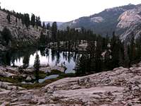
So I suggested to descend the north slopes of Alta Peak to Pear Lake and to gain the Lakes Trail as our descent route. This was a recommended variation in my guide book and it said that the descent to the lake is an easy one, though without a trail.
So we traversed the summit rock at its north side and went down below the east arête of Alta Peak to a gap east of the summit. A scree and talus chute was dropping down to some huge granite rock slabs leading further down to somewhat steeper parts of the Alta Peak north slope.
I kept left thinking about gaining a col in the north arête of Alta Peak, the western margin of Pear Lake. I was wrong. Our descent ended at the beginning of a steep rock chute which was not advisable at all without rappelling.
And then at last it started to rain. It always starts to rain when you need it least of all. To the right there was a system of ledges leading into the central granite rock face of the northern slopes and ending at the beginning of another steep scree chute leading down to more talus and granite slabs near the lake shore.
![Alta Peak]() Alta Peak north slope as seen from Pear Lake (16-09-2008)
Alta Peak north slope as seen from Pear Lake (16-09-2008)
So we started our somewhat slippery traverse which turned out to be a class 3 rock scramble which might be quite enjoyable with good weather but was not very pleasant in the pouring rain. With some heavy swearing we managed to reach the chute and stumbled and slided down the scree, followed by some talus hopping and scrambling.
The highly glacier polished granite slabs above the lake which had to be tackled next were nastily slippery and I traversed them like “on raw eggs” (a german saying), wondering how to circle the lake best: on its west or on its east side !??
Both sides showed a barrier of steep rocks which had to be overcome somehow to reach the northern end of the lake and to gain the Lakes Trail starting point. I decided to try the east side and soon stood in front of a 80 feet rockwall with a dihedral system of wide cracks offering a steep and exposed rock climb. I tried the crack on the right side first, it looked easier to manage but was getting more and more difficult and I abandoned the attempt.
![Alta Peak]() Great Western Divide (16-09-2008) Great Western Divide (16-09-2008) | ![Alta Peak]() Aster Lake / Lakes Trail (16-09-2008) Aster Lake / Lakes Trail (16-09-2008) | ![Alta Peak]() Fox Tail Pines (16-09-2008) Fox Tail Pines (16-09-2008) | ![Alta Peak]() Tharbs rock as seen from the summit - look for the mule deer (16-09-2008) Tharbs rock as seen from the summit - look for the mule deer (16-09-2008) |
There was the left side crack system left. After some very exposed steps I reached a sort of very tight rock chimney leading up to glacier polished slabs of granite. Thankfully the sun came back during my rock climbing and the granite dried up in no time. I managed to get through the chimney and checked the slabs above – this was the way to overcome the obstacle. I called my party and with much laughter they forced themselves through the tight cleavage.
We had then another well deserved break at the northern end of Pear Lake, studying our descent route and learning that we had chosen the somehow most difficult route to descend to the lake. The eastern side of the Alta Peak north slopes looked much easier than the western and central parts where our route was.
Then Lakes Trail was waiting for us, a scenic and great end of a long and great hike. Aster Lake, Emerald Lake and Heather Lake are like jewels embedded in the rough granite landscape. The weather was getting better and better and the sun escorted our afternoon descent back to Wolverton.
![Alta Peak]() Mule deer near summit (16-09-2008) Mule deer near summit (16-09-2008) | ![Alta Peak]() Alta Meadow (16-09-2008) Alta Meadow (16-09-2008) | ![Alta Peak]() Pear Lake from Alta Peak summit (16-09-2008) Pear Lake from Alta Peak summit (16-09-2008) |


Comments
Post a Comment