
-
 13856 Hits
-
 70.83% Score
-
 1 Votes
|
|
Route |
|---|---|
|
|
44.25480°N / 71.3213°W |
|
|
Hike/Scramble |
|
|
Most of a day |
|
|
Non-technical, significant scrambling |
|
|
Approach
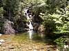
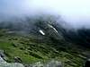
This route was originally designed as an emergency evacuation route off of Mount Washington and the Presidential Ridge. Now climbers wishing to avoid the hoards attempting to ascend Mounts Washington and Monroe from the east --via the Tuckerman's Ravine and Lion's Head routes-- can use the "Ammi" as a more peaceful alternative. The Ammonoosuc Ravine trailhead is located on the west side of the Mt. Washington massif in a parking lot on the Base Road --1.1 miles east of the Mount Clinton Road. On the 1978 USGS Mount Washington Quadrangle map, the trailhead is located at the Mansfield Station (for the Mt. Washington cog railway). The TH has since been moved to its current location on the Base Road a little less than a half mile west of the base station. From the TH, a well established and rather rocky path climbs gently for about 2 miles to the Gem Pool --a beautiful cascade draining into an emerald pool. This spot presents a good place for a break before the truly rigorous climbing begins (the trail climbs 2300 feet in the next mile).
 |  |  |  |  |
Route Description
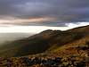
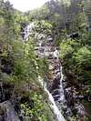
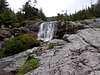
After passing the Gem Pool, the trail climbs steeply along side a pair of impressive 600 foot parallel waterfalls, crosses two brooks and enters an area of dense krummholz. Guidebooks describe the brook crossings as being on flat ledges. The guides fail to mention that these ledges are a nearly verticle scramble. Much of the remainder of the climb up to the ridge is a scramble up rock slabs that can be dangerously slippery when wet. Allthough this direct climb up the Ammonoosuc Ravine headwall is non-technical, it is a vigorous and occasionally tricky route that may be out of the comfort zones of many novice or casual climbers. The route, marked by cairns and occasional blue or yellow arrows painted onto the rock slabs, reaches the top of the headwall at treeline --directly behind the Appalachian Mountain Club's Lakes of the Clouds Hut. The hut is located on a tundra plateau at the base of Mt. Monroe's summit cone approximately 1 mile south of the final approach to Mt. Washington's summit. From the hut, it is a fairly simple climb, marked by cairns, with minimal scrambling to Mt. Monroe's main summit. The route continues over the summit and descends into a small saddle and climbes to the peak's secondary summit --sometiimes referred to as "Little Monroe".
 |  |  |  |  |
Essential Gear
Since the road to the trailhead is closed during the winter, this is only a three season route. Although it is a non-technical climb, the descent can be perilously slippery if the rock is wet, and a rope may be helpful. The weather above treeline on this mountain can be deadly during any season. The extreme weather conditions on Mt. Monroe rival those on its notorious northern neighbor and should never be taken lightly. At a minimum. climbers attempting to summit this peak --even during the summer-- should bring along warm clothing that retains its insulation value when wet, as well as good rain gear.
 |  |  |
Miscellaneous Info
If you have information about this route that doesn't pertain to any of the other sections, please add it here.