Comments
No comments posted yet.

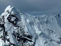 Mariposa summit ridge from the other side
Continuing, the summit of Ausangate is peaking over a nearby rocky subsidiary.
Then a lower hill of which I don't know the name, west northwest of Campa pass. There are trails left and right of this hill to the small village of Pacchanta.
Turning further, the steep southern slopes of the Callangate chain appear, with Pachanta as its southernmost peak. The main summit of Callangate isn't visible from here.
6 June 2011.
Mariposa summit ridge from the other side
Continuing, the summit of Ausangate is peaking over a nearby rocky subsidiary.
Then a lower hill of which I don't know the name, west northwest of Campa pass. There are trails left and right of this hill to the small village of Pacchanta.
Turning further, the steep southern slopes of the Callangate chain appear, with Pachanta as its southernmost peak. The main summit of Callangate isn't visible from here.
6 June 2011.


