
-
 20098 Hits
-
 80.49% Score
-
 12 Votes
|
|
Canyon |
|---|---|
|
|
33.53700°N / 111.3457°W |
|
|
Canyoneering |
|
|
Spring, Fall, Winter |
|
|
Overview
Apache Trail Canyon is an "unnamed" non-technical canyon in the northern Superstition Mountains east of Phoenix, Arizona. Located in the Tonto National Forest near Tortilla Flat and Canyon Lake, it has been called Apache Trail Canyon due to the proximity of the canyon to Highway 88...also known as The Apache Trail National Scenic Byway. This picturesque road extends from Apache Junction to Globe and passes by Canyon Lake, Apache Lake, and Theodore Roosevelt Lake. Tortilla Flat is an interesting stop on this Byway as it is a remnant of an Old West town, and only has a population of 6! This Byway also boasts the only access to Lost Dutchman State Park which is a popular starting point for many hikes and climbs into the Superstition Mountains including The Flatiron, and The Hand. Sculpted rock in the upper narrows.
The best times of the year to go are spring, fall, and winter. Summer can be extremely hot, and the July-August monsoon rains can bring deadly flash floods into the canyon. MAKE SURE THERE IS NO RAIN FALLING ANYWHERE IN THE WATERSHED BEFORE ENTERING THE CANYON!!!! For up-to-date weather click here.
The difficulty of the canyon using the American Canyoneering Academy rating system is 2A I which means that there is some scrambling and downclimbing involved, dry or very little water with some wading, and total trip time of just a few hours. The total trip takes 2-4 hours and is about 3-4 miles roundtrip.
Canyon Description
 In the upper narrows.
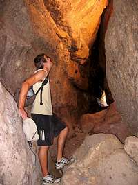 In a boulder cave.
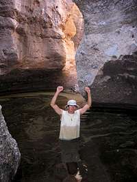
The head of Apache Trail Canyon has a short 100 foot section of Utah-like sandstone narrows with several pools. The main entry point is a short class 2/3 downclimb just below the narrows. There is an optional rappel into the head of the canyon from a boulder if you so desire, but it is unnecessary. Follow the meager footpath along the right side of the narrows until you find a cleft that allows you to downclimb into the canyon. The footpath continues on, but leads to a nastier chimney downclimb about 100 feet further on. I recommend the first. Once down the initial downclimb, turn left to head up into the narrows. There may be several chest deep pools that require wading to reach the head of the canyon.
 Tall walls near the exit.
Backtrack back down the canyon until you reach the spot where you downclimbed. Continuing down the canyon at this point requires either a short 15 foot rappel into a deep pool, a downclimb into that same pool, or a downclimb utilizing some webbing as a handline. We opted for the latter. Soon you will encounter large 40-50 foot boulders that have fallen in a jumbled fashion into the canyon. These make a fun and exciting challenge to routefinding, as well as creating caves to explore. Just be careful and watch out for potential 'keeper' holes formed by the boulders. There is plenty to keep you busy for hours if you like.
 Looking out from a boulder cave.
The canyon opens up eventually and is free of further boulders. At this point you are near the end. This final part of the canyon is a simple wash between 200 foot high walls. Once the canyon widens and the walls become slopes, head to the right and pick the easiest way up the slope. Once on the ridge, bear to your right and stay on the ridge as much as possible to avoid the wash to the north. Follow the ridge (and your eyesight!) back to your car.
Getting There
Drive on US 60 (aka Superstition Freeway) to exit 196. Head northeast on State Highway 88 past the Superstition Mountains. The Flatiron will dominate the view as you continue around the mountains. The road winds down to Canyon Lake and soon passes Tortilla Flat. Approximately 3 miles past Tortilla flat is a small parking pull-out on the left by a small cinder block structure. The canyon is directly across the road, down the slope, and follows the wash at the bottom to the right (southwest).Red Tape
The canyon is located in Tonto National Forest, and no fees or permits are required.Camping
Canyon Lake Marina has a campground with 22 RV sites with water and electric ($30/night), 6 dry RV sites ($25/night), and 19 tent sites ($20/night). Showers are available.Another option is the USDA Tonto National Forest Tortilla Campground near Tortilla Flat. The campground is open October through April. There are 77 sites, drinking water is available, and the fee per night is $12 per vehicle.
Essential Gear
Bring along a short section of climbing rope, harness, and rappel device. OR bring along two 20 foot pieces of webbing to sling boulders and use as a handline.When we went, there was a piece of webbing slung around a rock that we tied our handline to (we weren't worried about a fall into a deep pool). We just left our handline there and came back down from the car to retrieve it at the end of our hike.
Maps
The USGS 7.5 minute map Horse Mesa Dam (AZ) is the one to get.Links
Todd's Desert Hiking Guide has a great route description and more pictures.American Canyoneering Academy