
|
|
Route |
|---|---|
|
|
41.04760°N / 74.9726°W |
|
|
Hiking |
|
|
Spring, Summer, Fall, Winter |
|
|
Half a day |
|
|
Class I |
|
|
Approach
Go to the link for the Mochian Outdoor Center (MOC) follow those directions but park at the parking lot 1/4 mile from the MOC on Camp Road.Route Description
Go into the woods heading north on the Appalachian Trail (A.T.).Follow the A.T. in to the woods.
The trail gains about 400 ft in the first 0.4 miles, with very little elevation change while on the ridge.
At 1.4 miles the Rattlesnake Swamp Trail will come in from left. Stay on A.T.
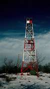
At 2.4 miles you will reach the fire tower and the summit.
Return the same way or when you reach the Rattlesnake Swamp Trail follow it down to the MOC and back to your car. ( See Rattlesnake Swamp Trail route for more info)
 |  |