
|
|
Route |
|---|---|
|
|
41.32070°N / 74.6615°W |
|
|
Hike |
|
|
Half a day |
|
|
Walk-up |
|
|
Getting There
AUTHOR'S NOTE: THIS ROUTE SHOULD NOT BE CONFUSED WITH THE APPALACHIAN TRAIL APPROACH FROM THE SOUTH THAT BEGINS ON ROUTE 23 NEAR THE ENTRANCE TO HIGH POINT STATE PARK.From NY: Take I-84 Exit 2 and proceed south on County Route 55 (AKA Mountain Road). This road crosses into New Jersey approximately 3.3 miles from the Interstate and becomes Route 519 but keeps the Mountain Road moniker. The Appalachian Trail crosses the road approximately 2/10 of a mile into New Jersey. Park on the shoulder of the road.
From NJ: The State Route 23/County Route 519 split is located approximately 1 mile southeast of the entrance to High Point State Park. From this point, follow Mountain Road (County Route 519) north for 2.3 miles to the Appalachian Trail crossing. Park on the shoulder of the road.
Trail Description
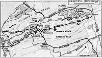 Area Map
A detailed map of the area can be obtained from the New York/New Jersey Trail Conference. The appropriate map for this hike is the North Kittatinny Trails map (number 18). A four-set Kittatinny Trails map is available for $12.95 and can be obtained here.
Added by RobA regarding Monument Trail:
The current blazes for the Monument Trail in red, but it used to be blue. When it was blue, it took a different route to the top than it does today. Not all of the blue blazes have been covered up. Make sure you follow the red blazes, the blue ones stop in the middle of the woods 100 yards after the A.T.