
|
|
Route |
|---|---|
|
|
41.21300°N / 74.4434°W |
|
|
Hiking |
|
|
Spring, Summer, Fall, Winter |
|
|
Less than two hours |
|
|
Class I |
|
|
Approach
Wawayanda is located in Wawayanda State Park, in between Vernon, NJ and New Milford, NY.Route 94 Trailhead: From Interstate 80.
Exit on Exit 19 (Hackettstown and Andover)
Go North on County Road 517
Stay on Route 517 untill it intersects State Road 94 just before the south base of Mountain Creek Ski Area
Follow Rt. 94 North in to Vernon, NJ
Continue all the way through Vernon and 2.4 miles after leaving Vernon and 0.6 miles after passing Maple Grange Road there is a parking lot on your right. Park there and head North on the Appalachian Trail.
 |
Route Description
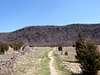
Start by passing through A.T. Parking lot.At 0.2 miles you will cross a gravel quarry road.
At 0.4 miles cross the first of many stone walls with views of Pochuck Mt. and Vernon Valley.
At 0.5 miles you will reach the base of the steep escarpment of Wawayanda Mt.
At. 0.7 miles you will reach Annie's Bluff with limited views
At. 1.0 miles the final climb of the mountain begins.
At 1.3 miles reach the blue blazed, 0.1 mile Pinwheel's Vista Trail.
At 1.4 miles reach the summit (sign register if it is still there). The Blue blazed Wawayanda Ridge Trail comes in from the east and leads to where the old Appalachian Trail reached the ridge and a viewpoint.
 |  |  |  |  |