
-
 3801 Hits
-
 72.08% Score
-
 2 Votes
|
|
Route |
|---|---|
|
|
35.72990°N / 82.2911°W |
|
|
Hike/Light Bushwhack |
|
|
Less than two hours |
|
|
Easy but requires routefinding |
|
|
Approach
See Getting there in the main page. For this route you can either park at the Stepps Gap visitor center or at the Mount Mitchell Parking area. Potato Knob is about 1.4 miles one way from Stepps Gap and about 3.6 miles from the Mount Mitchell Parking area.Route Description
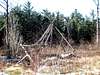
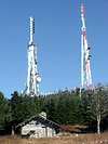
From Mount Mitchell State park take the Old Mitchell Trail 2 miles to Stepps Gap. At the gap, cross the road towards a gravel road marked "Mount Mitchell Radio Tower." Take the road snaking right and up the flank of Mount Gibbes. Take in the nice views to your right. Eventually you'll reach a fork in the road which is the col between Clingman's Peak and Mount Gibbes. Take the road to the right, where you will see a fence prohibiting access to Clingman's Peak. You're going to go around the northwest side of this peak.After turning right at the col, you'll soon see a few turnoffs marking a faint trail to the right. Take the first one (when I was here in October 2005 there was a pile of lumber visible from the road). Almost immediately you'll come across a fork. Take the left fork (and a left at the remaining two or three forks from here on out). The trail is quite easy to follow, and you will catch a glimpse of the Clingman Peak fence from time to time. After about 10 minutes you'll come across a clearing with a small dwelling. Cut directly across this clearing and continue on the trail. After 5 minutes or so you'll see another trail to your left. Take this left. If you come across another clearing with a teepee structure you've gone fifteen paces too far.
At this point the growth becomes quite thick, and you'll follow a boundary between the state park and the USFS which is marked often as a bear preserve. You can use the signs marking this as confirmation you're on the right route. The trail descends to the Clingman's Peak/Potato Knob col, and you'll have slight views to the north. Begin your ascent, and set your compass. Try to keep the bearing in mind, as you'll come across a thatch of dead firs and rocky ground that makes it hard to follow a trail. The trail may be easier to follow when there is no snow on the ground.
There isn't much in the way of views, but you'll know you're at the top when your path converges with other faint trails (or so I've heard...I couldn't find this in the snow). After completing this, come back the way you came or descend by the southeast ridge to Black Mountain Gap.
 |  |