
-
 12506 Hits
-
 84.82% Score
-
 19 Votes
|
|
Area/Range |
|---|---|
|
|
44.92030°N / 109.09°W |
|
|
Hiking, Scrambling |
|
|
Spring, Summer, Fall, Winter |
|
|
5090 ft / 1551 m |
|
|
Overview
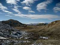 Lookings towards the Beartooths
Badger Basin is a large badlands area located in northwest Wyoming that is approximately 130 square miles in size; it is bordered on the east by Polecat Bench, on the south by Heart Mountain, and on the west by the Beartooth Range in the Northern Absarokas. Covered by sage brush, cactus, and yucca plants, this desolate yet starkly beautiful place is home to a wide range of wildlife, including antelope, deer, rattlesnakes, coyotes, and many others. Prominent geographic features in the basin include the Kimball and Chapman benches in the southwest and the Badland Hills in the center. The Clark's Fork of the Yellowstone River cuts into the basin from the west on its way up into Montana, and the area has two important drainages, Big Sand Coulee in the north and Little Sand Coulee in the south.
 Yucca Plant
 Rock Formation
It is easy to dismiss this area as ugly when compared to the majestic forested and alpine peaks that rise up to 10,000 and 12,000 feet less than ten miles to the west, but if you take the time to get out into the land away from the roads, there is a plethora of interesting and beautiful things to be see hidden among the hills and valleys that make up this place.
 In the Badland Hills
Getting There
There are two highways that run through Badger Basin; Highway 120 runs north from Cody, Wyoming around the west side of Heart Mountain and up to Bridger Montana, while Highway 294 connects the Cody-Powell Highway (14A) to Highway 120 around the northeast of Heart Mountain. Two important BLM roads provide access to other areas in the basin. The Big Sand Coulee Road runs through the very flat northern half of the basin where there are some oil fields and wells. The Little Sand Coulee Road cuts across the southern half and provides access to the Badland Hills and several small lakes.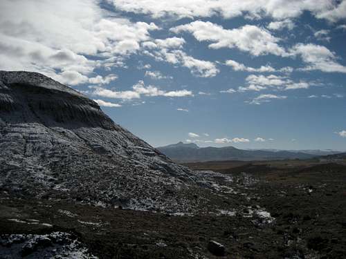 Heart Mountain in the distance
Mountain List
All of the peaks in Badger Basin are located in the Badlands Hills quadrangle, and are accessed by the Little Sand Coulee Road. There are four unnamed mountains here with over 300 feet of prominence; while not very impressive in height, these peaks are surprisingly fun Class 2 and 3 climbs that require some route finding on steep terrain.Thanks to ListsofJohn.com for the prominence numbers.
| Image | Peak Name | Elevation | Prominence | Map Link |
|---|---|---|---|---|
 |
Peak 5090 - Badland Hills Highpoint | 5,090 | 503 | Map |
 |
Peak 4990 - Badland Hills North | 4,990 | 380 | Map |
 |
Peak 4932 - Badland Hills East | 4,932 | 302 | Map |
 |
Peak 4923 - Badland Hills West | 4,923 | 309 | Map |
Red Tape
There are no fees to hike in Badger Basin. This area is mostly BLM land with a few very small parcels of Wyoming state land scattered throughout. Fences generally separate these areas and run along the highways; cattle graze this land from time to time, so the fences and cattle guards help keep the animals off of the road. Since it is pretty much all federal and state land, hiking is allowed throughout the entire area. Judging by some deep animal tracks and some pretty torn up places on the 4WD roads that branch off of the main dirt roads, this area gets pretty treacherous when it is wet, so exercise caution.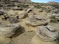 Rock Garden
 Small Stream
This is prime rattlesnake country with very little in the way of established trails, so every step taken while walking around the basin takes you close to another clump of sage brush that could hide a snake. For this reason, the winter months may be the best time to hike this area, as the snakes will stay in or very close to their dens during the cold season; if you do hike here in the summer, always keep listening and watching!
External Links
Information on the Badland Hills Quadrangle:Badland Hills
What to do in case of a Rattlesnake bite:
http://www.whmentors.org/saf/snakes.html
Camping
Standard BLM regulations for camping apply throughout the basin. There is very little water here, so plan accordingly. For more information, visit the BLM camping rules page at:http://www.blm.gov/pgdata/etc/medialib/blm/wy/information/docs.Par.1775.File.dat/wynf-0019.pdf
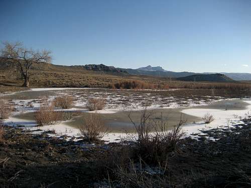 Heart Mountain seen over a small lake