
-
 3665 Hits
-
 80.49% Score
-
 12 Votes
|
|
Mountain/Rock |
|---|---|
|
|
44.80660°N / 109.1154°W |
|
|
Park |
|
|
Hiking, Scrambling |
|
|
Spring, Summer, Fall, Winter |
|
|
4923 ft / 1501 m |
|
|
Overview
 Rock pinnacle on Peak 4923
This is the lowest mountain in the Badland Hills area in Badger Basin. Like Peak 4932, it has some very neat badlands formations nestled within the valleys and ridges surrounding the peak. This particular mountain shows more evidence of the effects of water than the other three mountains in the range, and there are numerous creek beds to be jumped over and crossed on the way to the mountain. The deep, silty dirt found around many of the sandstone pillars that adorn the hillsides is a reminder that flash floods in this area are the norm during a downpour.
As with the other mountains in this area, the views of the Beartooth Range are great, and Heart Mountain is an impressive sight to the south. This is a short hike, but it takes place over rough, rocky ground with no trail, so rattlesnakes are a very real concern if you are exploring this area when it is warm.
Getting There
To reach Peak 4923 from Cody, Wyoming, head towards Powell on Highway 14A for about 13 miles and turn left on Highway 294. From Powell, go towards Cody for about 8.5 miles and turn right. Drive on 294 for 8.4 miles and turn left on Little Sand Coulee Road, which is the unmarked dirt road that crosses over a green cattle guard through the fence. This road is in pretty good shape with just a couple of rough spots where water drainage has damaged the road, but there is no need for 4WD. Drive for about 6.5 miles and park on the side of the road. Summit view west to Bald Peak
 Split rock formation
Head towards the left side of the mountain, keeping in mind that the highpoint visible for most of the hike is not the actual summit, which is hidden behind on another ridge. After about one half of a mile, there is a barbed wire fence to cross; this is a boundary between BLM and Wyoming State land. After crossing under the fence, continue to the left around the farthest ridge. Start climbing up the ridge on the west side of the small canyon, which will soon put you in a wide area of wonderful rock formations. From here, follow the ridge to the summit, which at times has a steep drop on either side.. The top is a small block of rock, which entails a Class 3 climb of about 10 feet.
The total distance for this hike is 1.5 miles one way with about 300 feet of elevation gain.
 Peak 4923 summit block
Red Tape
There are no fees to hike in Badger Basin. This area is mostly BLM land with a few very small parcels of Wyoming state land scattered throughout. Fences generally separate these areas and run along the highways; cattle graze this land from time to time, so the fences and cattle guards help keep the animals off of the road. Since it is pretty much all federal and state land, hiking is allowed throughout the entire area. Judging by some deep animal tracks and some pretty torn up places on the 4WD roads that branch off of the main dirt roads, this area gets pretty treacherous when it is wet, so exercise caution. It would probably be best to avoid this area during hunting season, so check with the Cody BLM office about dates.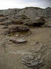 Rock field
 Small creek
This is prime rattlesnake country with very little in the way of established trails, so every step taken while walking around the basin takes you close to another clump of sage brush that could hide a snake. For this reason, the winter months may be the best time to hike this area, as the snakes will stay in or very close to their dens during the cold season; if you do hike here in the summer, always keep listening and watching!
Camping
Standard BLM regulations for camping apply throughout the basin. There is very little water here, so plan accordingly. For more information, visit the BLM camping rules page at:http://www.blm.gov/pgdata/etc/medialib/blm/wy/information/docs.Par.1775.File.dat/wynf-0019.pdf
External Links
Information on the Badland Hills Quadrangle:Badland Hills
What to do in case of a Rattlesnake bite:
http://www.whmentors.org/saf/snakes.html