
-
 10683 Hits
-
 90.13% Score
-
 31 Votes
|
|
Route |
|---|---|
|
|
46.07002°N / 7.67567°E |
|
|
Mountaineering, Scrambling, Skiing |
|
|
Spring, Summer, Fall |
|
|
Most of a day |
|
|
PD - |
|
|
I |
|
|
Overview
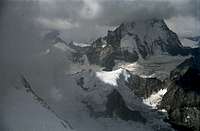
In the Valais Alps you can find many gems, far away from the “classic” 4000er – routes and summits. Unknown gems to most mountaineers. Summits which are much lower than the “grand summits” of the area. Blanc de Moming is such a gem. And the Arete du Blanc – route is the polish for that gem.Located in the center of the triangle Zinalrothorn - Weißhorn - Dent Blanche at the very upper end of Val d´Anniviers the surrounding of Blanc de Moming is wild. Ice cascades, sharp ridges, huge glaciers, deep valleys and immense rock faces build a remote and unique surrounding. It’s a must if you want to escape the hustle and bustle of Zematt surroundings and the well-known routes.
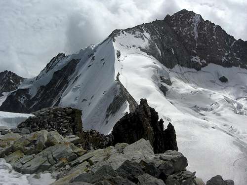 Arete du Blanc and Zinalrothorn Arete du Blanc and Zinalrothorn |  Arete du Blanc and Blanc de Moming (right) as seen from Schalihorn ascent Arete du Blanc and Blanc de Moming (right) as seen from Schalihorn ascent |
Arete du Blanc is part of the connecting ridge Blanc de Moming – Zinalrothorn. It is a mixed snow – ice and rock, or better, talus ridge, in some parts similar to famous Biancograt of Piz Bernina. The odd thing is: the starting point of the ridge is higher than the summit (see the route description)! But this does not spoil the fun.
Combine Arete du Blanc with the descent via the southwest ridge to a great traverse of Blanc de Moming. Or tackle it during a spring ski tour ascent to Blanc de Moming with the famous and great downhill route via Glacier de Moming.
Getting There
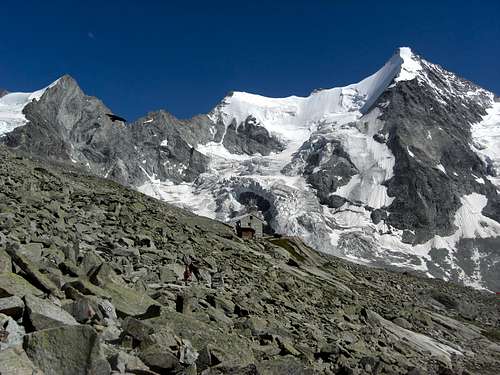 Cabane du Mountet
Starting point for that route is Cabane du Mountet.
You reach this swiss alpine club hut from the last parking area south of Zinal by following the closed forest road up to Le Vicchiesso, an old alm hut. At the footbridge across the Navisence creek there are two possibilities:
West route: This is the old route to the hut, however, due to glacier retreat and rockfall not the best one. Follow the supply road to the Cabane du Petit Mountet. A trail starts behind the hut following the moraine crest first and then traversing the steep east slopes of Grand Cornier in ups and downs.
The trail descends then to Glacier du Zinal and crosses the mostly talus and scree covered glacier below Glacier des Bouquetins to the east side of the Zinal glacier. Another trail starts there ascending to the hut.
East route: Cross the Navisence on the foot bridge and follow the signposts to “Grand Mountet” at the trail junction after the bridge. A good trail starts ascending the moraine and then in some zigzags the northwest slopes of Besso. At about 2400 m starts the long traverse of the Besso slopes in southern directions, traversing some gullys and steep ravines. After a steep ascent to a sort of notch in the southwest ridge of Besso you reach the talus cirque of former Glacier du Besso. The red and white signs guide you through this chaos to the west ridge of Le Mammouth and finally to Cabane du Mountet.
 Blanc de Moming Blanc de Moming | 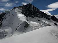 Arete du Blanc and Zinalrothorn Arete du Blanc and Zinalrothorn |  Blanc de Moming as seen from Bishorn Blanc de Moming as seen from Bishorn |
Route Description
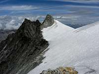
 On the Arete du Blanc
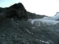
Follow the trail that starts at the hut and goes in southern direction to the moraine bordering the huge cirque of the Glacier du Mountet. Follow the trail on the moraine crest in northeastern direction. At a level part you recognise left hand a broad col in the ridge between Le Mammouth and Blanc de Moming, it is called La Forcle.
Don´t climb La Forcle, follow some cairns to your right and aim to the west border of upper Mountet glacier below the southwest ridge of Blanc de Moming.
Ascend on the glacier (rope, ice axe and crampons) in northeastern direction to a snow col ahead of you. This snow col marks the beginning of both Arete du Blanc and the northern arête of Zinalrothorn to L´Epaule.
You have to overcome a bergschrund, which in 2012 had several subsequent crevasses, to reach the col at a height of about 3750 m.
Only with good snow cover you can reach Arete du Blanc a bit earlier, too, by ascending one of the steep snow chutes west of the above mentioned snow col.
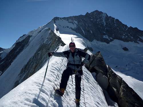
Turn left at the col and follow nearly level or slightly descending the fine snow ridge crest of Arete du Blanc. A steeper descent has to be made on a talus and rock part of the ridge (about UIAA grade I). After that you reach another snow part of the Arete du Blanc. Follow this snow ridge best on its crest line in some ups and downs. Depending on the snow conditions follows a mixed snow and rock terrain until you reach a col which marks the lowest point of Arete du Blanc (about 3580 m).
 La Forcle and snow col above Glacier du Mountet La Forcle and snow col above Glacier du Mountet | 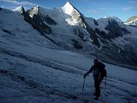 Ascent on Glacier du Mountet Ascent on Glacier du Mountet | 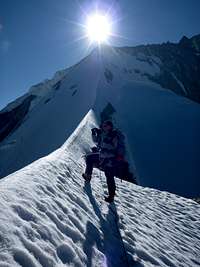 On the ridge crest On the ridge crest |
Ascend the secondary summit of Blanc de Moming by following the scree ridge or the snow and ice part north of the ridge. There is a huge cairn south of this secondary summit marking the end or beginning of the southwest ridge route.
 Routes Overview Routes Overview |  Routes Overview Routes Overview |
Traverse the ice and snow cap of the fsecondary summit into a col south of Blanc de Moming summit. Pay attention: there are some hidden crevasses! Climb the snow/ice and the talus and scree slope to Blanc de Moming summit.
Allow 3 to 4 hours for the whole ascent.
 On the ridge crest On the ridge crest |  Arete du Blanc Arete du Blanc |  Dent Blanche and Grand Cornier Dent Blanche and Grand Cornier |
Gear & Route Condition
 Geared up on the Arete
Arete du Blanc is a mixed glacier and (easy) rock route which can bring much fun even though Blanc de Moming is one of the lower Valais ice peaks. The route is rated PD-. I consent!
Crampons, ice axe and rope are obligatory. With normal conditions Arete du Blanc is not a very difficult route for those who know how to behave on glaciers. With ice and bad weather, however, Arete du Blanc can be a serious undertaking. Ask the landlord of Cabane du Mountet about the actual conditions. He will give you good advive (only in French!) and gladly will show you a photo map with the proper route.
The Arete du Blanc is a ski tour, too. Ascent via Glacier du Zinal, Glacier du Mountet and the Arete du Blanc, downhill via Glacier du Moming on its left side (steep and full of crevasses but rated as one of the best ski tour descents of the Alps!).
Current Weather:
Maps & Guide Books
 Obergabelhorn as seen from the Arete Obergabelhorn as seen from the Arete |  Dent Blanche as seen from the Arete Dent Blanche as seen from the Arete |  Besso as seen from the summit Besso as seen from the summit |
The main guidebooks, available in German, are
 Tiny Blanc de Moming below mighty Dent Blanche, as seen from Bishorn Tiny Blanc de Moming below mighty Dent Blanche, as seen from Bishorn |  A bunch of celibates near La Forcle A bunch of celibates near La Forcle |