Whiteface and Passaconaway
It was already March, and I wanted to get out and play in the mountains after spending the previous 6 weeks doing things around the house. In truth, I got my first taste of mountain hiking during the winter in January 2007 and after three large New England storms, the snow pack seemed to be melting away fast. I knew if I was going to do any more mountains before the solstace, this would be my last chance. The spring solstace was little more than a week away.
Due in part to my minimal winter experience, I am still growing comfortable in full winter conditions. As a result, I prefer to have a hiking partner to somewhat minimize risk. I was striking out all around. Then through one of my hiking forums, I was approached by Mats, who was attempting to break the time record for the winter completion of all 48 peaks in the White Mountains measuring 4000 feet. As it so happened, Mats was going to be hiking Whiteface Peak and Mount Passaconaway on the same day (March 12, 2007) I wanted to go hiking. Furthermore, if I was successful on Passaconaway, it would be my 40th summit towards completing all 48 recognized peaks.
As Mats was also planning on attempting both Isolation and perhaps the Tripyramids after our hike, we agreed to meet at 8am at the Ferncroft parking lot.
I left my house on time and of course, about 10 miles down the road I realized that I had left my Gore-tex pants at home. As various forecasts suggested as many as 4 feet of snow along the summit ridges in NH, I decided that these pants were imperative to the hike. Fortunately, this was the the only faux-paux of the trip. I got a hold of Mats and was at the trailhead by 8:30am. By 9:00am Mats and I were on the trail. Mats had equipped himself with the Kahtoola FLIGHTsystem for his attempt and was easily able to switch between the studded boots and snowshoes. (This is not a product review so on with the trip report).
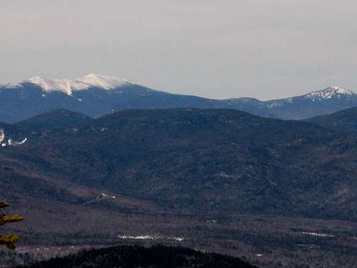
![Tripyramids from Passaconaway]() Tripyramids from Passaconaway
Tripyramids from Passaconaway We chose to go up the Blueberry Ledge Trail as both of us had previously been up the ledges and did not want to come down the icy ledges. Another bonus of the Blueberry Ledge Trail is that it has many viewpoints for the surrounding area. About a 1.5 miles from the parking area, is an open area where the Blueberry Ledge Cutoff Trail intersects the Blueberry Ledge Trail. We were there in under an hour and the sun was warming up the frosty air. At this point, I had already shed the Gore-tex pants I returnd hom to grab. The pants did not leave my pack for the rest of the day (the snow was dry powder). Oh well, can't win them all.
Mats and I continued hiking. I did my best to lead though the trail was well broken, so I was not saving Mats as much effort as I had hoped. We got to the next overlook, which looks back on the Ferncroft parking area. After a quick snack break we were on our way over a ridge, on our way to the ledges. Up at 3300 feet, the snow was much deeper. Mats and I had the pleasure of following some moose tracks along the trail. I for one was glad I was not post holing 2+ feet like the moose was.
The ledges were icy, but snow-covered and as the sun was still shining, we were treated with lovely views of Chocorua and the Presidential Range. We stopped to snap for pictures at the overlook on the south summit of Whiteface. The wind was whipping around, so we were happy to have the scrub trees to give us some protection. Mats had done ridge walks of the Presidentials and Carters the prvious two days so he was happy to be out of the gusts.
The true summit was nothing more than a slight bump along the ridge. We were there in under 3 hours from leaving the trailhead. Mats stopped and did 10 pushups at the highpoint and we kept going. Now we were on the Rollins Trail, which was not broken out extensively. In fact much of the trail was poorly marked. Some snowshoe marks were the only guide. Prior to loosing too much elevation off of Whiteface, we were greeted with another nice view north towards Mount Washington and the Presidential Range.
Much of the rest of the ridge walk is wooded and affords only local views into the basin. A couple of shoots into the Basin were easily avoided. About a quarter mile from the junction with the Dicey Mill Trail, the Rollins Trail transformed itself from a barely travelled route to well packed highway.
![Franconia Ridge and Mount Garfield from the Lookout]() Garfield and Franconia Range
Garfield and Franconia Range Apparently a large group set itself up in an off-trail campsite nearby. At the Dicey Mill Trail, we climbed the steep 7/10ths of a mile to the summit. The snow-conditions were just right for some group to glissade down the trail from the summit.
The summit is wooded and affords no view, however there is a nice viewpoint looking west less than a tenth of a mile from the summit. After a quick summit shot, (#40 marked off) great views of snowcapped Franconia Ridge and also the Sandwich Wilderness with the Tripyramids and the ski slopes of Mt. Tecumsah (Waterville Valley) in the distance were enjoyed.
The easy slopes down the Dicey Mill Trail led us past the old Mill site and back to Ferncroft, completing the 11.9 mile loop in just over 6 hours.
Update on the Record
Mats decided to give his feet a rest after our hike. Unfortunately as the week progressed Mother Nature did not cooperate. The skies opened and the rain came. With the rain the snow became too soft and the quest bogged down.
Although a new time record was not set, it was a pleasurable time in the mountains. Hopefully Mother Nature will cooperate for another attempt next winter.


Comments
Post a Comment